Showing 8061 items
matching blocked
-
 Melbourne Tram Museum
Photograph - Black & White Photograph/s and Printer Photograph Plate Block, c1970
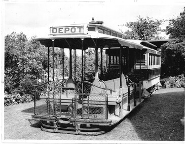
Set of two photographs of the cable tram set collected and conserved by Alf Twentyman at his Northcote property, in Bastings St. .1 - Black and white photograph of the cable car set pushed out in the open with the garden alongside. Grip car 436 and trailer 586 - see http://www.tramway.org.au/collections_cable.html accessed 23/6/17 for details. .2 - Printer Photograph Plate Block - wood back with a zinc metal plate used for printing in a magazine or book showing the garden setting at Bastings St with the cable set in the view.On rear of photograph "No. 8 see front" in pencil.trams, tramways, cable trams, grip tram, northcote, gardens -
 Melbourne Tram Museum
Newspaper, John Masanauskas, "Our rotting treasurers", "More brakes put on W-class return", 29/11/2001 12:00:00 AM
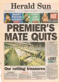
Newspaper clipping - two sheets - from the Herald Sun newspaper, Thursday 29/11/2001 about the tramcar and parts stored at Newport Workshops East block - includes photos. Page 1 - titled "Our rotting treasurers" has a photo of the W's lined up in the former workshop. Article written by John Masanauskas - Transport Reporter Page 4 - titled "More brakes put on W-class return" with a photo of dismantled motors and a tramcars in the background. Includes comments by Rupert Hamer, John So and John Cain.trams, tramways, newport workshops, stored trams, w class -
 Melbourne Tram Museum
Photograph - Block Mounted Photograph, c1936-37
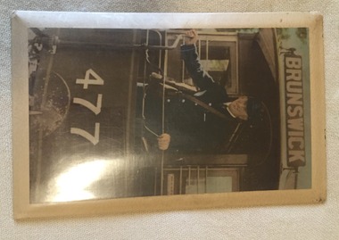
Block mounted photograph on a metal backing sheet which has a packing between a stippled card sheet and the photograph to give a curved effect with an outer plastic cover and a mounting cord on rear. Photograph of John McMahon as MMTB conductor badge Number 772 on the rear platform of cable car trailer No. 477, with one hand on a hand brake. Shows the MMTB style conductors bag and ticket folder or holder. Has the destination sign set for "Brunswick" Photograph may be hand coloured by a studio photographer.trams, tramways, cable trams, mmtb, conductors, brunswick, tram 477 -
 Melbourne Tram Museum
Photograph - Block Mounted Photograph, Ron Scholten, c1970
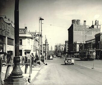
Chipboard base for a block mounted black and white photograph of Elizabeth St Melbourne at Franklin St. Has a stapled nylon cord on rear to provide a hanging method. Has tram W5 728 north bound to Brunswick on a route 18. In the background is the Argus building, printers of The Argus and The Australasian. Note the safety zone. Photo and story along with a photograph by Warren Doubleday of the same location September 2014 used in the October 2014 issue of Bellcord - see image i3. First two pages extracted only.On rear in ink at the top - "Donated to Hawthorn Tram Museum Feb. 19th 2012 Ron Scholten"trams, tramways, elizabeth st, brunswick, route 18, the argus, franklin st, tram 728 -
 Melbourne Tram Museum
Decorative object - Memento, Siemens, glass block containing an image of the Siemens Supra Plus, 2007
Memento or Memento - dark blue cardboard box with folder cap fitted dark blue cotton padding containing a glass block containing an image of the Siemens Supra Plus, about the 100% low floor tram that was tested in Melbourne , Lisbon C008, running between March and June 2007. Has the Siemens, Australasian Railway Association (ARA) and Yarra Trams logos embedded as well. Presented to passengers on the occasion of an ARA dinner held at Luna Park, possibly June 2007. See Reg item 245 for an associated pamphlet.trams, tramways, siemens, tramcars, combino -
 Melbourne Tram Museum
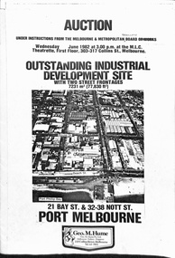
Pamphlet, Geo M Hume, "Auction - Outstanding Industrial development site - Port Melbourne", May. 1982
Draft of a pamphlet - folded A3 sheet for the sale in June 1982 of the former Port Melbourne Bus Depot, near the corner of Bay St and Beach St. Consists of two sheets of 150gsm ? paper bound together with an adhesive tape. A loose sheet showing the layout of the various titles included as well. Note the correction to the owners name from the MMBW to the MMTB. Includes an aerial photo of the site, photos of the buildings, addresses of the block, a site plan, title particular, terms of sale and the Vendors Agent, Geo M Hume.trams, tramways, mmtb, buses, sale of land, port melbourne depot -
 Melbourne Tram Museum
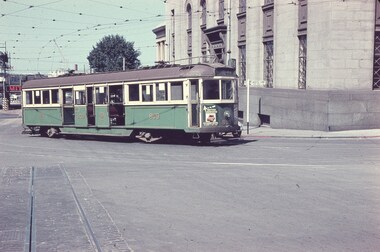
Slide, Keith Caldwell, 12/03/1960 12:00:00 AM
Agfa Colour slide, cardboard mount, by Keith Caldwell dated 12 March 1960, of W5 809 turning from Market St into Flinders Lane. Tram has two sets of monograms and numbers on the sides, is fitted with trolley wheels and showing route 55. Has an advertisement for British Bedford's vehicles on the front. The strip for the advert racks on the sides of the trams has been installed. In front of the tram is a remnant of cable tram track in wood blocks. In the background is the Flinders St Viaduct and the Port of Melbourne Authority Building.in ink on top of the slide "W5 (Cable tracks), Market" and hand stamped "12 Mar '60"trams, tramways, market st, flinders lane, w5 class, cable trams, tram 809 -
 Melbourne Tram Museum
Magazine, Dick Kerr, "Ferodoisation", mid 1960's
Manuscript - two typed quarto sheets - titled "Ferodoisation" written by "Dick Kerr", looking at the use of Ferodo brake shoes in Melbourne. Looks at costs, service, noise, braking, disadvantages of noise, smell, dust and braking effort. See also Reg Item 3054 - "Electric Traction - May 1969", that has an article by "Richard Kerr" - most likely the same author and the collector - Bob Prentice. With the manuscript are two photographs of the brake blocks and drawing of a wheel marked Fig 1 and Fig 2 - these are not referenced in the article.trams, tramways, mmtb, brakes, ferodo brakes shoes, braking, tramcars -
 Melbourne Tram Museum
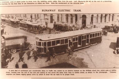
Photograph - Black and White photograph, late 1920's
Sepia toned photograph titled "Runaway Electric Tram" of a W class tram that has over run or runaway from the William St terminus and is blocking cable trams in Collins St. Could be tram 230, 236, 290, 296. Has the original newspaper caption under neath - date not know - late 1920's. Shows tramway staff (captioned as Engineers) attaching a cable to pull the tram back over the intersection. Possibly one a set of cards made for the 70th anniversary of South Melbourne Depot.trams, tramways, w class, accidents, collins st, william st, cable trams -
 Melbourne Tram Museum
Ephemera - Christmas Card, Peter Duckett, 1997
Christmas Card prepared by Peter and Patti Duckett and sent to Keith Kings Printed photo on exterior with red printed ribbons, photo corners on inside with another photo and gold block print and the Duckett's address. Photographs by Peter Duckett or from his collection. Item used for 1997 Christmas Cover photo features an Electric Supply Company tram hauling a well loaded trailer in Sturt St Ballarat, c1906. Inside photo is of the Ballarat Tramway Museum horse tram No. 1 on the access track."To Keith" in ink.trams, tramways, ballarat, horse trams, trailers, btm, tram 1 -
 Melbourne Tram Museum
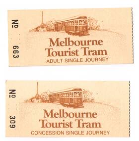
Ephemera - Ticket/s, The Met, "Melbourne Tourist Tram", 1980's?
Set of two tickets on fawn colour card, with printing and image in dark brown ink. Number in black ink. Both tickets for the Melbourne Tourist Tram Service. (Operational history??) Image is of a W1 class tram. .1 - Adult Single Journey - No. 663 .2 - Concession Single Journey - No. 309 Both have been torn from a block. Has notes regarding use on the back of ticket. Additional copies added 207-2018 from Vic Solomons. .1 - No. 641 .2 - No. 275trams, tramways, tickets, tours, melbourne, tourist trams, w2 class -
 Eltham District Historical Society Inc
Photograph, K.D. Ingram's Shell Garage, Research, Vic, c.1930
The inscription on the back of the photo incorrectly states the garage is at Anglesea. It is in fact at Research, Victoria. Kenneth Douglas Ingram moved from Research to his hoiliday home at 9 Minfrie Avenue, Anglesea between 1943-1949. He established a new garage at Anglesea which was a concrete block design building, not a tin shed as this at Research. This garage was located between the family home and the public hall at Research on the original line of Main Road. The public hall site is now the site of the Eltham Little Theatre. The family home, a red brick building still stands today (2023) at 1591 Main Road, ResearchOn reverse "Garage, Anglesea"k.d. ingram shell garage, kenneth douglas ingram, main road, pam thoonen (nee ingram) collection, research (vic.), research garage -
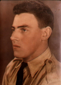 Waverley RSL Sub Branch
Photograph, L.A.C. Leonard John Hudson 156990 7ACS R.A.A.F
Leonard John Hudson was born in Prahran and moved to Castlemaine in his early years At the beginning of the war was refused entry to the services due to his "reserved occupation" as a motor mechanic working on farm machinery At night he worked as a machinist for Thompson's Foundry machining breech blocks for 25 pound field guns. (image) Eventually he was granted enlistment into the R.A.A.F. into 7 Airfield Construction Squadron as a Leading Aircraftsman 156990 and was sent to Milne Bay with the unit to build the air strip.As one of few diesel mechanics he was often required to assist the US troops with their maintenance problems at various sites in or near New Guinea. Rare surviving images of 7 ACS newsletter Hand coloured photograph of L. J. Hudson in RAAF tropical uniform 1944 Copies of the "Spruiker" Magazine illustrations from August 1945 published at Milne Bay by 7ACS (7th Airfield Construction Squadron) Photograph of 25lb. Field Gun at Thompsons Foundry Pages from Photo Album showing L. J. Hudson in uniform at Castlemaine (one with his wife R. J. Hudson ) and at Milne Bay7 acs, 7 a.c.s., milne bay, thompsons foundry, field gun, l. hudson, len hudson, castlemaine, 25 pound field gun, hudson, spruiker, 7th airfield construction squadron -
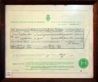 City of Moorabbin Historical Society (Operating the Box Cottage Museum)
Document - Copy of Marriage Certificate William Box 1854, 14 May 1997
This copy of the Marriage Certificate of William and Elizabeth Avis-Box was obtained by CMHS member Dennis Maynard in May 1997. William Box and Elizabeth Avis Box came to Australia with his parents George and Mary Cripps-Box and siblings in 1856 William Box with his wife Elizabeth Avis Box and 13 children lived and farmed on the block of land in Jasper Road, East Brighton ( now McKinnon / Ormond) that was part of the Henry Dendy Special Survey 1841. Caroline Box, the eldest daughter of George and Mary Cripps-Box, remained in England working as a cook until she joined the family in Australia in 1863. William Box with his wife Elizabeth Avis Box and 13 children lived and farmed on the block of land in Jasper Road, East Brighton ( now McKinnon / Ormond) that was part of the Henry Dendy Special Survey 1841 Box Cottage Museum is the reconstructed pioneer cottage that William and Elizabeth lived in 1865 until they built a new house on the land. The Certified Copy of the Marriage Entry of William Box and Elizabeth Avis at the Parish Church, Tonbridge, Kent, England on November 13th 1854 in a wood frame with glass* CERTIFIED COPY OF AN ENTRY OF MARRIAGE / crest / GIVEN AT THE GENERAL REGISTER OFFICE / Application number C009059/0 / 1854 Marriage solemnised at The Parish Church of Tonbridge in the County of Kent / 206 / November 13th / 1854 / William Box 20 Bachelor Gardener / Elizabeth Avis 19 Spinster/ ………… Signed by William Box , Elizabeth Avis with Thomas Avis and Caroline Box as the Witnesses. Issued at Tonbridge 14th May 1997 MXA 171379 box william, box elizabeth avis, moorabbin, ormond, parish of tonbridge, farmers, dairy, market gardeners, pioneers, early settlers, kent, england, certificates, box caroline, avis thomas, -
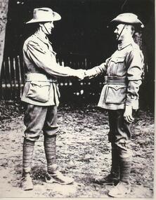 Lake Bolac & District Historical Society
Black and white photograph, Pte Donald Murray meeting Pte Ray Hargreaves in London during WW1
Private Donald Hector Murray greeting Private Edward Raymond Hargreaves in London during WW1. Donald enlisted 17/04/1916 in the 37th Infantry Battalion and embarked for Europe 03/06/1916. He died of Tubercular Pleurisy on 21/12/1916 at the Military Hospital, Fargo England, whilst on active service. He is buried in the Durrington Cemetery there. Edward enlisted in the 5th Infantry Battalion on 08/07/1915 and embarked for France 11/10/1915. Upon his return he was granted a Soldier Settler's block west of Lake Bolac in 1921. He married Flora Graham in 1925. murray, 37th infantry battalion, hargreaves, graham, 5th infantry battalion, london, ww1, fargo military hospital, durrington cemetery, lake bolac -
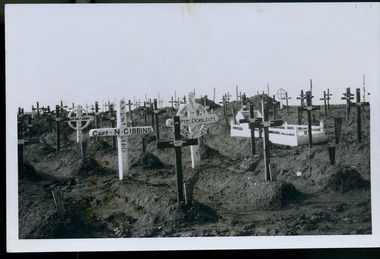 Magnet Galleries Melbourne Inc
Soldier's cemetery, les chandler_a00171.tif
Rows of graves from the Battle of Fromelles, then called Flerbaix. Among the graves is that of Captain Norman Gibbins, 55th Battalion, born in Ararat Victoria. A Gallipoli veteran, at Fromelles, Gibbins fought a desperate rear guard bombing action while under heavy German attack. It allowed many Australians including the wounded to get back to the safety of their own lines. When his path was blocked by dead and wounded Gibbins stood up and was fatally shot. His body was recovered and moved seven kilometres behind the lines where his grave was one of 111 Australians initially buried at Sailly-sur-la-lys. ww1, world war 1, cemetery, fromelles, flerbaix, norman gibbins, aif, a.i.f -
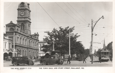 Ballarat Tramway Museum
Postcard, Rose Stereograph Co, "The Town Hall and Sturt Street Ballarat Vic", 1930s
Rose Series - P1713, titled "The Town Hall and Sturt St, Ballarat Vic" with an ESCo tram with a "Vote No" on the front dash panel, two taxis mid-block, and the Town Hall in the background. Drivers standing along both taxis. On the rear in pencil in a note to Ken Magor of Newcastle, Wal Jack has written: "Ballarat old type No. 6. Note route colors square coloured sheet right hand side above driver's head & lower destination sign. Also note side adverts boards on car roof. See item 3581 for a copy negative and 5177 for a digital image of this postcard. Yields information about Ballarat 's trams in the 1930's and three street scene at the City Centre with the Town Hall in the background. Shows nature of the area with street lights and parked motor vehicles and a sign on the tram regarding prohibition and a vote on the banning of the sale of alcohol.Postcard black and white, divided back, with a handwritten note on rear.See image 2 for details of the handwritten note by Wal Jack on the rear. tramways, trams, esco, sturt st, lydiard st, taxis, town hall, tram 6 -
 Ballarat Tramway Museum
Administrative record - SEC Ballarat Depot monthly report, State Electricity Commission of Victoria (SECV), 1971
Record of the monthly reports from April 1965 to July 1971, signed by the Depot Foreman S Lakey, D Irwin or acting F. Minns. Lists the number of brake blocks replaced and summarises the principal work done on the tramcars and special jobs eg replacing the destination rolls. image i2 - April 1965 to December 1966 image i3 - Jan. 1967 to December 1968 - including an entry dated 10-9-1968 with a list of depot staff, addresses and phone numbers, 17 in all. image i4 - Jan. 1969 to December 1970 image i5 - Jan 1971 to July 1971Yields information about the Ballarat Workshop activities, tramcars maintained and events on a monthly basis.Memo reporting book, with sheets headed "Departmental State Electricity Commission of Victoria" - ruled, carbon copy with heavy card covers with green tape binding. Form SF-466-12-0254. A sheet of carbon paper remains in the book as if for the next entry.ballarat, tramcars, workshop records, workshops, maintenance -
 Kew Historical Society Inc
Plan, Borough of Kew Detail Plan No.1577, 1904
The Melbourne and Metropolitan Board of Works (MMBW) plans were produced from the 1890s to the 1950s. They were crucial to the design and development of Melbourne's sewerage and drainage system. The plans, at a scale of 40 feet to 1 inch (1:480), provide a detailed historical record of Melbourne streetscapes and environmental features. Each plan covers one or two street blocks (roughly six streets), showing details of buildings, including garden layouts and ownership boundaries, and features such as laneways, drains, bridges, parks, municipal boundaries and other prominent landmarks as they existed at the time each plan was produced. (Source: State Library of Victoria)This plan forms part of a large group of MMBW plans and maps that was donated to the Society by the Mr Poulter, City Engineer of the City of Kew in 1989. Within this collection, thirty-five hand-coloured plans, backed with linen, are of statewide significance as they include annotations that provide details of construction materials used in buildings in the first decade of the 20th century as well as additional information about land ownership and usage. The copies in the Public Record Office Victoria and the State Library of Victoria are monochrome versions which do not denote building materials so that the maps in this collection are invaluable and unique tools for researchers and heritage consultants. A number of the plans are not held in the collection of the State Library of Victoria so they have the additional attribute of rarity.Original survey plan, issued by the MMBW to a contractor with responsibility for constructing sewers in the area identified on the plan within the Borough of Kew. The plan was at some stage hand-coloured, possibly by the contractor, but more likely by officers working in the Engineering Department of the Borough and later Town, then City of Kew. The hand-coloured sections of buildings on the plan were used to denote masonry or brick constructions (pink), weatherboard constructions (yellow), and public buildings (grey). MMBW Plan No.1577 includes some of the most significant houses in Kew: Herbert Henty’s ‘Roxeth’ (now part of Trinity Grammar), ‘Butleigh Wooton’, ‘Bokara’ and ‘Harrow’. It also includes the streets that have since changed their names. That part of College Parade linked to Glenferrie Road is now named College Place, College Parade now extends further north, and Charles Street did not yet reach Barkers Road. Roxeth is one of a number of Henty houses in Kew. Herbert Henty made his home here and was elected a member of Kew Municipal Council in 1864 and mayor in 1868-69. Walter Henry Serle, of Harrow served in the First World War. He was awarded the Military Medal ‘’For conspicuous bravery and devotion to duty. On 29th September near BELLICOURT he showed the greatest bravery and determination when his platoon was attacked by enemy bombing parties. It was due largely to his personal efforts that all the attacks were repulsed. Until wounded, his utter disregard of personal safety and boldness in dealing with the attacks were the means of saving the situation and were an inspiring example to his men.’melbourne and metropolitan board of works, detail plans, maps - borough of kew, mmbw 1577, cartography -
 Kew Historical Society Inc
Plan, Melbourne & Metropolitan Board of Works : Borough of Kew : Detail Plan No.1578, 1904
The Melbourne and Metropolitan Board of Works (MMBW) plans were produced from the 1890s to the 1950s. They were crucial to the design and development of Melbourne's sewerage and drainage system. The plans, at a scale of 40 feet to 1 inch (1:480), provide a detailed historical record of Melbourne streetscapes and environmental features. Each plan covers one or two street blocks (roughly six streets), showing details of buildings, including garden layouts and ownership boundaries, and features such as laneways, drains, bridges, parks, municipal boundaries and other prominent landmarks as they existed at the time each plan was produced. (Source: State Library of Victoria). This plan forms part of a large group of MMBW plans and maps that was donated to the Society by the Mr Poulter, City Engineer of the City of Kew in 1989. Within this collection, thirty-five hand-coloured plans, backed with linen, are of statewide significance as they include annotations that provide details of construction materials used in buildings in the first decade of the 20th century as well as additional information about land ownership and usage. The copies in the Public Record Office Victoria and the State Library of Victoria are monochrome versions which do not denote building materials so that the maps in this collection are invaluable and unique tools for researchers and heritage consultants. A number of the plans are not held in the collection of the State Library of Victoria so they have the additional attribute of rarity.Original survey plan, issued by the MMBW to a contractor with responsibility for constructing sewers in the area identified on the plan within the Borough of Kew. The plan was at some stage hand-coloured, possibly by the contractor, but more likely by officers working in the Engineering Department of the Borough and later Town, then City of Kew. The hand-coloured sections of buildings on the plan were used to denote masonry or brick constructions (pink), weatherboard constructions (yellow), and public buildings (grey). MMBW Plan No.1578 is significant in that it defines the extent of two private schools: Xavier College and Kew High School (now part of Trinity Grammar) by 1904. In relation to the latter, the plan clarifies which buildings the High School operated from behind the mansion ‘Molina’. Established in 1902, Trinity Grammar was to later lease and subsequently buy Molina (now ‘Merritt House’) and ‘Elsinore’ (now ‘Roberts House’). Xavier College had been established in 1872. This 1904 plan delineates the West Wing and the Great Hall (built in 1890).melbourne and metropolitan board of works, detail plans, maps - borough of kew, mmbw 1578, cartography -
 Kew Historical Society Inc
Plan, Melbourne & Metropolitan Board of Works. Borough of Kew Detail Plan No.1579, 1904
The Melbourne and Metropolitan Board of Works (MMBW) plans were produced from the 1890s to the 1950s. They were crucial to the design and development of Melbourne's sewerage and drainage system. The plans, at a scale of 40 feet to 1 inch (1:480), provide a detailed historical record of Melbourne streetscapes and environmental features. Each plan covers one or two street blocks (roughly six streets), showing details of buildings, including garden layouts and ownership boundaries, and features such as laneways, drains, bridges, parks, municipal boundaries and other prominent landmarks as they existed at the time each plan was produced. (Source: State Library of Victoria). This plan forms part of a large group of MMBW plans and maps that was donated to the Society by the Mr Poulter, City Engineer of the City of Kew in 1989. Within this collection, thirty-five hand-coloured plans, backed with linen, are of statewide significance as they include annotations that provide details of construction materials used in buildings in the first decade of the 20th century as well as additional information about land ownership and usage. The copies in the Public Record Office Victoria and the State Library of Victoria are monochrome versions which do not denote building materials so that the maps in this collection are invaluable and unique tools for researchers and heritage consultants. A number of the plans are not held in the collection of the State Library of Victoria so they have the additional attribute of rarity.Original survey plan, issued by the MMBW to a contractor with responsibility for constructing sewers in the area identified on the plan within the Borough of Kew. The plan was at some stage hand-coloured, possibly by the contractor, but more likely by officers working in the Engineering Department of the Borough and later Town, then City of Kew. The hand-coloured sections of buildings on the plan were used to denote masonry or brick constructions (pink), weatherboard constructions (yellow), and public buildings (grey). While MMBW Plan No.1579 does not include many buildings, those that it does show are significant to Kew’s history. These include the ‘Kew [Railway] Station’ in Denmark Street and the ‘Recreation Hall’ and rear courts off Wellington Street. The plan shows the outline of the Recreation Hall, constructed in 1880, at the rear of which is listed a bowling green, two tennis courts, a ‘skittle alley’ and a pavilion. When the Hall was first built, the Kew Cricket Club occupied an adjacent ground, however in 1885 this was acquired by the State Government as the future location of the Kew Railway Station. The Plan also shows a single oval at Xavier College. This oval was completed in 1883. One of the current ovals conforms to this oval’s original shape and position in the school grounds.melbourne and metropolitan board of works, detail plans, maps - borough of kew, mmbw 1579, cartography -
 Kew Historical Society Inc
Plan, Melbourne and Metropolitan Board of Works, Borough of Kew : Detail Plan No.1580, 1904
The Melbourne and Metropolitan Board of Works (MMBW) plans were produced from the 1890s to the 1950s. They were crucial to the design and development of Melbourne's sewerage and drainage system. The plans, at a scale of 40 feet to 1 inch (1:480), provide a detailed historical record of Melbourne streetscapes and environmental features. Each plan covers one or two street blocks (roughly six streets), showing details of buildings, including garden layouts and ownership boundaries, and features such as laneways, drains, bridges, parks, municipal boundaries and other prominent landmarks as they existed at the time each plan was produced. (Source: State Library of Victoria)This plan forms part of a large group of MMBW plans and maps that was donated to the Society by the Mr Poulter, City Engineer of the City of Kew in 1989. Within this collection, thirty-five hand-coloured plans, backed with linen, are of statewide significance as they include annotations that provide details of construction materials used in buildings in the first decade of the 20th century as well as additional information about land ownership and usage. The copies in the Public Record Office Victoria and the State Library of Victoria are monochrome versions which do not denote building materials so that the maps in this collection are invaluable and unique tools for researchers and heritage consultants. A number of the plans are not held in the collection of the State Library of Victoria so they have the additional attribute of rarity.Original survey plan, issued by the MMBW to a contractor with responsibility for constructing sewers in the area identified on the plan within the Borough of Kew. The plan was at some stage hand-coloured, possibly by the contractor, but more likely by officers working in the Engineering Department of the Borough and later Town, then City of Kew. The hand-coloured sections of buildings on the plan were used to denote masonry or brick constructions (pink), weatherboard constructions (yellow), and public buildings (grey). The area represented in this detail plan has undergone significant change during the 20th century. The widening of High Street in the 1930s and 1950s involved the shops on the south side of High Street being demolished and later rebuilt to fit the widened street. Another significant loss was the mansion ‘Drayton’ fronting Wellington Street, owned at this stage by Susannah Fenton. Her family name would later to be given to Fenton Way, which was to be built over the grounds of the house following its demolition. The plan of the garden is particularly interesting, containing a batten dome fronting Wellington Street, an ornamental pond, a fountain and a brick and glass conservatory. The notes by the plumbing contractor on this plan are particularly detailed. Pink borders delineate the ownership of the varying parcels of land. Some of the better known owners listed include the real estate agent Cr. Henry de Castres Kellett (bt) and John Padbury, the funeral director. This particular plan provides a clear view of the configuration of the Kew Junction in 1903 and the commercial buildings that surrounded it.melbourne and metropolitan board of works, detail plans, maps - borough of kew, mmbw 1580, cartography -
 Kew Historical Society Inc
Plan, Melbourne & Metropolitan Board of Works : Borough of Kew : Detail Plan No.1581, 1904
The Melbourne and Metropolitan Board of Works (MMBW) plans were produced from the 1890s to the 1950s. They were crucial to the design and development of Melbourne's sewerage and drainage system. The plans, at a scale of 40 feet to 1 inch (1:480), provide a detailed historical record of Melbourne streetscapes and environmental features. Each plan covers one or two street blocks (roughly six streets), showing details of buildings, including garden layouts and ownership boundaries, and features such as laneways, drains, bridges, parks, municipal boundaries and other prominent landmarks as they existed at the time each plan was produced. (Source: State Library of Victoria)This plan forms part of a large group of MMBW plans and maps that was donated to the Society by the Mr Poulter, City Engineer of the City of Kew in 1989. Within this collection, thirty-five hand-coloured plans, backed with linen, are of statewide significance as they include annotations that provide details of construction materials used in buildings in the first decade of the 20th century as well as additional information about land ownership and usage. The copies in the Public Record Office Victoria and the State Library of Victoria are monochrome versions which do not denote building materials so that the maps in this collection are invaluable and unique tools for researchers and heritage consultants. A number of the plans are not held in the collection of the State Library of Victoria so they have the additional attribute of rarity.Original survey plan, issued by the MMBW to a contractor with responsibility for constructing sewers in the area identified on the plan within the Borough of Kew. The plan was at some stage hand-coloured, possibly by the contractor, but more likely by officers working in the Engineering Department of the Borough and later Town, then City of Kew. The hand-coloured sections of buildings on the plan were used to denote masonry or brick constructions (pink), weatherboard constructions (yellow), and public buildings (grey). The streets and built structures in this plan were surveyed in 1903 and released to contractors in 1904. In addition to the designation of building types by colour, the plan includes detailed descriptions of land use and ownership. While many buildings remain from this period, a number of the buildings represented have been demolished including the original Kew Town Hall, and the Congregational and Roman Catholic churches in Walpole Street. While the mansion ‘Illapa’ in Princess Street is still extant – now part of ‘Rylands’ – the neighbouring mansion ‘Elsmere’ was demolished some decades ago. Rivalling Illapa and Elsmere in size were two mansions in Walpole Street, one named on the plan as ‘Gnarlbine’. Over time, Kew Junction and the south side of High Street have been reconfigured and widened, so that the commercial buildings on the corner of Princess and High Street no longer exist. A surprising feature of this part of central Kew to the northwest of Kew Junction is the amount of vacant land. In a number of cases, this land is noted by the contractor as used for vegetable gardens.melbourne and metropolitan board of works, detail plans, maps - borough of kew, mmbw 1581, cartography -
 Kew Historical Society Inc
Plan, Melbourne & Metropolitan Board of Works : Borough of Kew : Detail Plan No.1582, 1904
The Melbourne and Metropolitan Board of Works (MMBW) plans were produced from the 1890s to the 1950s. They were crucial to the design and development of Melbourne's sewerage and drainage system. The plans, at a scale of 40 feet to 1 inch (1:480), provide a detailed historical record of Melbourne streetscapes and environmental features. Each plan covers one or two street blocks (roughly six streets), showing details of buildings, including garden layouts and ownership boundaries, and features such as laneways, drains, bridges, parks, municipal boundaries and other prominent landmarks as they existed at the time each plan was produced. (Source: State Library of Victoria)This plan forms part of a large group of MMBW plans and maps that was donated to the Society by the Mr Poulter, City Engineer of the City of Kew in 1989. Within this collection, thirty-five hand-coloured plans, backed with linen, are of statewide significance as they include annotations that provide details of construction materials used in buildings in the first decade of the 20th century as well as additional information about land ownership and usage. The copies in the Public Record Office Victoria and the State Library of Victoria are monochrome versions which do not denote building materials so that the maps in this collection are invaluable and unique tools for researchers and heritage consultants. A number of the plans are not held in the collection of the State Library of Victoria so they have the additional attribute of rarity.Original survey plan, issued by the MMBW to a contractor with responsibility for constructing sewers in the area identified on the plan within the Borough of Kew. The plan was at some stage hand-coloured, possibly by the contractor, but more likely by officers working in the Engineering Department of the Borough and later Town, then City of Kew. The hand-coloured sections of buildings on the plan were used to denote masonry or brick constructions (pink), weatherboard constructions (yellow), and public buildings (grey). Public buildings, coloured grey on the Plan 1582 include the police station and post office, churches and schools. The earliest church school, Common School No.356 was located at the rear of the Congregational Church in Peel Street. It was constructed in 1859. The first buildings of Kew Primary School No.1075 on the other side of Peel Street were constructed in 1871. The school in 1903 only occupied a small fraction of its current site. In 1903, where the rear playground is now located, were two weatherboard and one brick villa. Trinity Grammar School was founded in 1902 and opened in the Parish Hall at the rear of Holy Trinity Anglican Church. It was not to move to its current site until 1906. The outline of the building housing the Kew Fire Brigade in the centre of the north side of Walton Street is shown but not named on the plan. Further down Pakington Street stood the two-storey Italianate mansion ‘Overton’. The home of Stanford Chapman, it was to be featured in the Imperial Institute series of bromide photographs of Victoria, Vol. 1: Homes and scenery. It was later to become a boarding house before it was later demolished.melbourne and metropolitan board of works, detail plans, maps - borough of kew, mmbw 1582, cartography -
 Kew Historical Society Inc
Plan, Melbourne & Metropolitan Board of Works : Borough of Kew : Detail Plan No.1585, 1904
The Melbourne and Metropolitan Board of Works (MMBW) plans were produced from the 1890s to the 1950s. They were crucial to the design and development of Melbourne's sewerage and drainage system. The plans, at a scale of 40 feet to 1 inch (1:480), provide a detailed historical record of Melbourne streetscapes and environmental features. Each plan covers one or two street blocks (roughly six streets), showing details of buildings, including garden layouts and ownership boundaries, and features such as laneways, drains, bridges, parks, municipal boundaries and other prominent landmarks as they existed at the time each plan was produced. (Source: State Library of Victoria)This plan forms part of a large group of MMBW plans and maps that was donated to the Society by the Mr Poulter, City Engineer of the City of Kew in 1989. Within this collection, thirty-five hand-coloured plans, backed with linen, are of statewide significance as they include annotations that provide details of construction materials used in buildings in the first decade of the 20th century as well as additional information about land ownership and usage. The copies in the Public Record Office Victoria and the State Library of Victoria are monochrome versions which do not denote building materials so that the maps in this collection are invaluable and unique tools for researchers and heritage consultants. A number of the plans are not held in the collection of the State Library of Victoria so they have the additional attribute of rarity.Original survey plan, issued by the MMBW to a contractor with responsibility for constructing sewers in the area identified on the plan within the Borough of Kew. The plan was at some stage hand-coloured, possibly by the contractor, but more likely by officers working in the Engineering Department of the Borough and later Town, then City of Kew. The hand-coloured sections of buildings on the plan were used to denote masonry or brick constructions (pink), weatherboard constructions (yellow), and public buildings (grey). This plan, which covers parts of High Street, Pakington Street and Derby Street is dominated by two historic Kew mansions: ‘Konetta’ and ‘Ramornie’. Ramornie was constructed in 1890 for James Maitland Campbell, three times Mayor of Kew. Sold in 1940, it became a boarding house known as ‘The Towers’. Now a private residence again, it has only one of its three balconies remaining. The location of the missing two balconies can be seen on the plan. In 1903, the grounds of Ramornie included a large tennis court fronting Pakington Street. The rear of the property is shown as extending to Cobden Street. One of Kew’s oldest hotels, the Prospect Hill Hotel on the corner of High and Cobden Street was established in 1858. The outline of the hotel shown on the plan represents the second building on the site. During the 19th century it was often used for electoral meetings. The Prospect Hill Hotel was to be redeveloped again in 1928, by the local architect Robert McIntyre. Since the 1980s, the hotel has been a live music venue, the home of the Melbourne Jazz Club, a restaurant and a liquor outlet.melbourne and metropolitan board of works, detail plans, maps - borough of kew, mmbw 1585, cartography -
 Kew Historical Society Inc
Plan, Melbourne & Metropolitan Board of Works : Borough of Kew : Detail Plan No.1588, 1904
The Melbourne and Metropolitan Board of Works (MMBW) plans were produced from the 1890s to the 1950s. They were crucial to the design and development of Melbourne's sewerage and drainage system. The plans, at a scale of 40 feet to 1 inch (1:480), provide a detailed historical record of Melbourne streetscapes and environmental features. Each plan covers one or two street blocks (roughly six streets), showing details of buildings, including garden layouts and ownership boundaries, and features such as laneways, drains, bridges, parks, municipal boundaries and other prominent landmarks as they existed at the time each plan was produced. (Source: State Library of Victoria)This plan forms part of a large group of MMBW plans and maps that was donated to the Society by the Mr Poulter, City Engineer of the City of Kew in 1989. Within this collection, thirty-five hand-coloured plans, backed with linen, are of statewide significance as they include annotations that provide details of construction materials used in buildings in the first decade of the 20th century as well as additional information about land ownership and usage. The copies in the Public Record Office Victoria and the State Library of Victoria are monochrome versions which do not denote building materials so that the maps in this collection are invaluable and unique tools for researchers and heritage consultants. A number of the plans are not held in the collection of the State Library of Victoria so they have the additional attribute of rarity.Original survey plan, issued by the MMBW to a contractor with responsibility for constructing sewers in the area identified on the plan within the Borough of Kew. The plan was at some stage hand-coloured, possibly by the contractor, but more likely by officers working in the Engineering Department of the Borough and later Town, then City of Kew. The hand-coloured sections of buildings on the plan were used to denote masonry or brick constructions (pink), weatherboard constructions (yellow), and public buildings (grey). This plan shows the original configuration of the Kew Post Office, Court House and Police Station, which had opened in 1888. This configuration was to essentially remain until the purchase of the Court House and Police Station by the City of Boroondara in 2007 and its subsequent renovation. Interestingly, the MMBW surveyors incorrectly labelled parts of the complex. In the triangle in front of the Post Office, before the erection of the Kew Cenotaph in 1925, was located a lawn and the Queen Victoria Jubilee Fountain. While many of the shops on the south side of High street had been constructed by 1903 a number of sites were still used as vegetable gardens. Further along High Street, on the corner of Charles Street, the Salvation Army Barracks can be seen on the plan. These Barracks predate the later Citadel and ‘Young People’s Hall’ that were opened in 1919. At 22 Charles Street can be seen the house of James Venn Morgan. Hailed as the ‘father of Kew’, Morgan arrived in Melbourne in 1840. He was first engaged as a bookmaker, but a fortunate venture on the goldfields enabled him to purchase land in Kew. He conducted a market garden and dairy in Kew for many years.melbourne and metropolitan board of works, detail plans, maps - borough of kew, mmbw 1588, cartography -
 Kew Historical Society Inc
Plan, Melbourne & Metropolitan Board of Works : Borough of Kew : Detail Plan No.1590, 1905
The Melbourne and Metropolitan Board of Works (MMBW) plans were produced from the 1890s to the 1950s. They were crucial to the design and development of Melbourne's sewerage and drainage system. The plans, at a scale of 40 feet to 1 inch (1:480), provide a detailed historical record of Melbourne streetscapes and environmental features. Each plan covers one or two street blocks (roughly six streets), showing details of buildings, including garden layouts and ownership boundaries, and features such as laneways, drains, bridges, parks, municipal boundaries and other prominent landmarks as they existed at the time each plan was produced. (Source: State Library of Victoria)This plan forms part of a large group of MMBW plans and maps that was donated to the Society by the Mr Poulter, City Engineer of the City of Kew in 1989. Within this collection, thirty-five hand-coloured plans, backed with linen, are of statewide significance as they include annotations that provide details of construction materials used in buildings in the first decade of the 20th century as well as additional information about land ownership and usage. The copies in the Public Record Office Victoria and the State Library of Victoria are monochrome versions which do not denote building materials so that the maps in this collection are invaluable and unique tools for researchers and heritage consultants. A number of the plans are not held in the collection of the State Library of Victoria so they have the additional attribute of rarity.Original survey plan, issued by the MMBW to a contractor with responsibility for constructing sewers in the area identified on the plan within the Borough of Kew. The plan was at some stage hand-coloured, possibly by the contractor, but more likely by officers working in the Engineering Department of the Borough and later Town, then City of Kew. The hand-coloured sections of buildings on the plan were used to denote masonry or brick constructions (pink), weatherboard constructions (yellow), and public buildings (grey). Surveyed by the Board of Works in 1903 and published in 1904, Plan No.1590 shows development north of Cotham Road. While this plan includes built structures in Mary Street, Cotham Road, High Street, Park Hill Road, Kent Street, Ridgeway Avenue, and Ermington Lane (now Ermington Place), only part of this section was notated and coloured in this contractor’s copy. Numerous houses, large and small are named on the plan: ‘Cholula’, ‘Belper’, ‘The Uplands’, ‘Spring Grove’ facing Cotham Road; ‘Marion’ facing Kent Street; and ‘Kia Ora’ facing Ridgeway Avenue.melbourne and metropolitan board of works, detail plans, mmbw 1590, survey plans - borough of kew, cartography -
 Kew Historical Society Inc
Plan, Melbourne & Metropolitan Board of Works : Borough of Kew : Detail Plan No.1591, 1905
The Melbourne and Metropolitan Board of Works (MMBW) plans were produced from the 1890s to the 1950s. They were crucial to the design and development of Melbourne's sewerage and drainage system. The plans, at a scale of 40 feet to 1 inch (1:480), provide a detailed historical record of Melbourne streetscapes and environmental features. Each plan covers one or two street blocks (roughly six streets), showing details of buildings, including garden layouts and ownership boundaries, and features such as laneways, drains, bridges, parks, municipal boundaries and other prominent landmarks as they existed at the time each plan was produced. (Source: State Library of Victoria)This plan forms part of a large group of MMBW plans and maps that was donated to the Society by the Mr Poulter, City Engineer of the City of Kew in 1989. Within this collection, thirty-five hand-coloured plans, backed with linen, are of statewide significance as they include annotations that provide details of construction materials used in buildings in the first decade of the 20th century as well as additional information about land ownership and usage. The copies in the Public Record Office Victoria and the State Library of Victoria are monochrome versions which do not denote building materials so that the maps in this collection are invaluable and unique tools for researchers and heritage consultants. A number of the plans are not held in the collection of the State Library of Victoria so they have the additional attribute of rarity.Original survey plan, issued by the MMBW to a contractor with responsibility for constructing sewers in the area identified on the plan within the Borough of Kew. The plan was at some stage hand-coloured, possibly by the contractor, but more likely by officers working in the Engineering Department of the Borough and later Town, then City of Kew. The hand-coloured sections of buildings on the plan were used to denote masonry or brick constructions (pink), weatherboard constructions (yellow), and public buildings (grey). That area of Kew bordered by Cotham Road, Park Hill Road, Ermington Lane (now Ermington Place), and Belmont Avenue contained some of the significant homes owned by Kew pioneers. Chief among these was ‘Park Hill’ on an enormous lot facing Park Hill Road. The Jubilee History of 1910 noted, six years after this plan was drawn, that: ‘Park Hill Road, forming the southern boundary of the cemetery, takes its name from Park Hill, the residence of Mr. Thomas Judd, who has resided there since December, 1852.’ Other named houses on the plan include ‘Ferndale’ facing Cotham Road; ‘Ermington’ adjacent to Judd’s Park Hill, facing Park Hill Road; and ‘Gilden’ and ‘Mont Belmont’ facing Belmont Avenue. Mont Belmont was designed by the architectural firm of Reed, Henderson and Smart for William George Lilley in 1887 and was completed in 1888. Lilley was Mayor of Kew in 1887-88, a Justice of the Peace and a member of the first Board of Guardians of Kew’s St. Hilary’s Church of England.melbourne and metropolitan board of works, detail plans, survey plans - borough of kew, mmbw 1591, cartography -
 Kew Historical Society Inc
Plan, Melbourne & Metropolitan Board of Works : Borough of Kew : Detail Plan No.1592, 1905
The Melbourne and Metropolitan Board of Works (MMBW) plans were produced from the 1890s to the 1950s. They were crucial to the design and development of Melbourne's sewerage and drainage system. The plans, at a scale of 40 feet to 1 inch (1:480), provide a detailed historical record of Melbourne streetscapes and environmental features. Each plan covers one or two street blocks (roughly six streets), showing details of buildings, including garden layouts and ownership boundaries, and features such as laneways, drains, bridges, parks, municipal boundaries and other prominent landmarks as they existed at the time each plan was produced. (Source: State Library of Victoria). This plan forms part of a large group of MMBW plans and maps that was donated to the Society by the Mr Poulter, City Engineer of the City of Kew in 1989. Within this collection, thirty-five hand-coloured plans, backed with linen, are of statewide significance as they include annotations that provide details of construction materials used in buildings in the first decade of the 20th century as well as additional information about land ownership and usage. The copies in the Public Record Office Victoria and the State Library of Victoria are monochrome versions which do not denote building materials so that the maps in this collection are invaluable and unique tools for researchers and heritage consultants. A number of the plans are not held in the collection of the State Library of Victoria so they have the additional attribute of rarity.Original survey plan, issued by the MMBW to a contractor with responsibility for constructing sewers in the area identified on the plan within the Borough of Kew. The plan was at some stage hand-coloured, possibly by the contractor, but more likely by officers working in the Engineering Department of the Borough and later Town, then City of Kew. The hand-coloured sections of buildings on the plan were used to denote masonry or brick constructions (pink), weatherboard constructions (yellow), and public buildings (grey). In MMBW Plan No.1592, the pink line indicates that area of the plan for which the contracting engineer was responsible. Included in the Plan are a number of primarily brick villas in a section of Belmont Avenue off Cotham Road. The house ‘Uvadale’ north of Belmont Avenue, and facing Cotham Road is also included in the contract. Excluded from the contract but shown on the Plan are ‘Glendonald’, ‘Mont Belmont’ and ‘Gilden’.melbourne and metropolitan board of works, detail plans, survey plans - borough of kew, mmbw 1592, cartography -
 Kew Historical Society Inc
Plan, Melbourne & Metropolitan Board of Works / Borough of Kew, Detail Plan No.1593, 1905
The Melbourne and Metropolitan Board of Works (MMBW) plans were produced from the 1890s to the 1950s. They were crucial to the design and development of Melbourne's sewerage and drainage system. The plans, at a scale of 40 feet to 1 inch (1:480), provide a detailed historical record of Melbourne streetscapes and environmental features. Each plan covers one or two street blocks (roughly six streets), showing details of buildings, including garden layouts and ownership boundaries, and features such as laneways, drains, bridges, parks, municipal boundaries and other prominent landmarks as they existed at the time each plan was produced. (Source: State Library of Victoria)This plan forms part of a large group of MMBW plans and maps that was donated to the Society by the Mr Poulter, City Engineer of the City of Kew in 1989. Within this collection, thirty-five hand-coloured plans, backed with linen, are of statewide significance as they include annotations that provide details of construction materials used in buildings in the first decade of the 20th century as well as additional information about land ownership and usage. The copies in the Public Record Office Victoria and the State Library of Victoria are monochrome versions which do not denote building materials so that the maps in this collection are invaluable and unique tools for researchers and heritage consultants. A number of the plans are not held in the collection of the State Library of Victoria so they have the additional attribute of rarity.Original survey plan, issued by the MMBW to a contractor with responsibility for constructing sewers in the area identified on the plan within the Borough of Kew. The plan was at some stage hand-coloured, possibly by the contractor, but more likely by officers working in the Engineering Department of the Borough and later Town, then City of Kew. The hand-coloured sections of buildings on the plan were used to denote masonry or brick constructions (pink), weatherboard constructions (yellow), and public buildings (grey). The laborious task of hand-tinting these Board of Works plans was not without hazards as is evidenced by Plan No. 1593. On the Plan, the original colourist spilt black and green ink, partially obscuring some parts. The most obvious casualty is ‘Clifton’ located on the corner of Cotham Road and Park Street [now Adeney Avenue]. Included in this Plan, and outlined in pink is that part of the section that the contracting engineer was tasked with completing. This included sewering on both sides of this part of Cotham Road, but excluded properties such as ‘Glendonald’ and ‘Monnington’. This area was to undergo a series of subdivisions including the ‘Clifton Estate’, which created housing lots on Adeney Avenue and Florence Avenue in 1916. The most notable occupant of Clifton was William Adeney [died 1893], a pioneer of Camperdown, after which Park Street was later renamed.melbourne and metropolitan board of works, detail plans, survey plans - borough of kew, mmbw 1593, cartography