Showing 9778 items
matching east street
-
 Orbost & District Historical Society
calendar, Old Views of Gippsland 2010, 2009
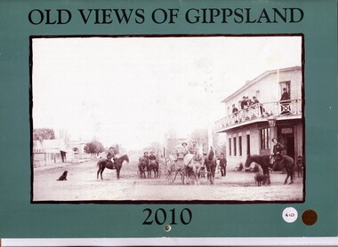
This calendar is one of a series published annually by East Gippsland Historical Society. It cost $10.This item is a useful reference tool.A 2010 stapled calendar, titled "Old Views of Gippsland". On the turquoise coloured front is a black/white photograph of the main street of Rosedale before the time of motor vehicles. It contains early photographs of East Gippsland, one for each month. There is a hole for hanging. The title is at the top and the year at the bottom in black print. -
 Orbost & District Historical Society
calendar, Old Views of Gippsland 2011, 2010
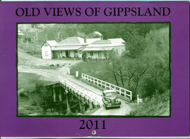
This is one of a series of calendars published annually by East Gippsland Historical Society.This item is a useful reference tool.A 2011 stapled calendar, titled "Old Views of Gippsland". On the purple coloured front is a black/white photograph of The Blue Duck Hotel at Angler's Rest on the road to Glenn Wills C/1940. It contains early photographs of East Gippsland, one for each month. There is a hole for hanging. The title is at the top and the year at the bottom in black print. calendar-old-views-of-gippsland photographs-historic-gippsland -
 Orbost & District Historical Society
calendar, Old Views of Gippsland 2012, 2011
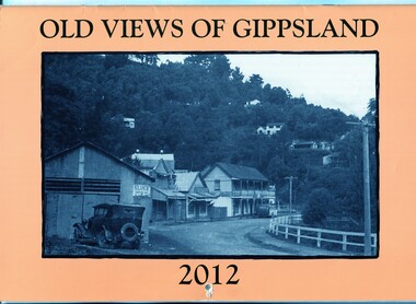
This item is one of a series of calendars published annually by East Gippsland Historical Society.This item is a useful reference tool.A 2012 stapled calendar, titled "Old Views of Gippsland". On the light tan coloured front is a black/white photograph of Main Road Walhalla looking south towards the Star Hotel C / 1951. It contains early photographs of East Gippsland, one for each month. There is a hole for hanging.The title is at the top and the year at the bottom in black print. -
 Orbost & District Historical Society
calendar, Old Views of Gippsland 2013, 2012
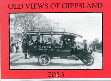
This item is one of a series published annually by East Gippsland Historical Society.This item is a useful reference tool.A 2013 stapled calendar, titled "Old Views of Gippsland". On the red coloured front is a black/white photograph of Bruthen - Omeo Royal Mail and Bus service run by Charles Mitchell of Bruthen, It contains early photographs of East Gippsland, one for each month. There is a hole for hanging. The title is at the top and the year at the bottom in black print. -
 Orbost & District Historical Society
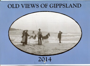
calendar, Old Views of Gippsland 2014, 2013
This is one of a series of calendars published annually by East Gippsland Historical Society.This item is a useful reference tool.A 2014 stapled calendar, titled "Old Views of Gippsland". On the blue coloured front is a black/white photograph of carriage horses being crossed through a lake entrance presumed to be Lake Tyers around the turn of the century C 1900 . It contains early photographs of East Gippsland, one for each month. There is a hole for hanging. The title is at the top and the year at the bottom in black print. -
 Orbost & District Historical Society
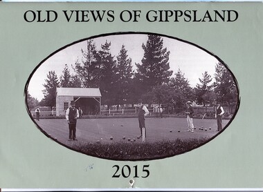
calendar, Old Views of Gippsland 2015, 2014
This is one of a series of calendars compiled and published by east Gippsland Historical Society.This is a useful reference tool.A 2015 stapled calendar, titled "Old Views of Gippsland". On the pale green coloured front is a black/white photograph of a Bowling Club Opening Day 7 December 1901 in front of trees in botanical gardens in the background. The photograph is credited as from the Ron Yeats Collection. The calendar contains early photographs of East Gippsland, one for each month. There is a hole for hanging. The title is at the top and the year at the bottom in black print. calendar-old-views-gippsland-2015 photographs-historic-gippsland -
 Orbost & District Historical Society
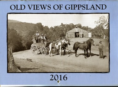
calendar, Old Views of Gippsland 2016, 2015
This item is one of a series of calendars compiled and published by East Gippsland Historical Society.This item is a useful reference toolA 2016 stapled calendar, titled "Old Views of Gippsland". On the light blue coloured front is a black/white photograph of Tongio Gap, Omeo, showing Mitchell's coach which ran from Bairnsdale to Omeo. The calendar contains early photographs of East Gippsland, one for each month. There is a hole for hanging. The title is at the top and the year at the bottom in black print. calendar-old-views-gippsland photographs-histporic-gippsland -
 Orbost & District Historical Society
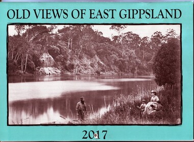
calendar, E-Gee Printers, Old Views of East Gippsland 2017, 2016
This is one of a series of calendars compiled annually by East Gippsland Historical Society.This is a useful pictorial reference tool.A 2017 stapled calendar, titled "Old Views of East Gippsland". On the turquoise coloured front is a black/white photograph of Eagle Point, Mitchell River C 1875 with a family group, possibly Alfred Howitt and children, on the bank of the Mitchell River opposite Eagle Point Bluff.. It contains early photographs of East Gippsland,. There is a hole for hanging. The title is at the top and the year at the bottom in black print. calendar-old-views-of-east-gippsland photographs-historic-east-gippsland -
 Orbost & District Historical Society
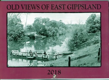
calendar, E-Gee Printers, Old Views of East Gippsland 2018, 2017
This is one a series of calendars compiled annually by East Gippsland Historical Society.This is a useful pictorial reference tool.A 2018stapled calendar, titled "Old Views of East Gippsland". On the purple coloured front is a black/white photograph of a punt on the Tambo River. It has a manual winding winch, three men on a small wharf, one man is fishing. It contains early photographs of East Gippsland, one for each month. There is a hole for hanging. The title is at the top and the year at the bottom in black print. calendar-old-views-of-east-gippsland photographs-historic-east-gippsland -
 Orbost & District Historical Society
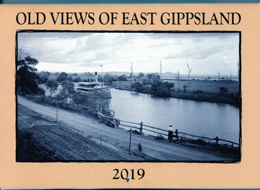
calendar, E-Gee Printers, Old Views of East Gippsland 2019, 2018
This calendar is pert of a series of calendars compiled by East Gippsland Historical Society.This item is a useful pictorial reference tool.A 2019stapled calendar, titled "Old Views of East Gippsland". On the pale orange coloured front is a black/white photograph of S.S, Gippsland on the Mitchell River, Eagle Point C 1920. IThe calendar contains early photographs of East Gippsland, one for each month. There is a hole for hanging. The title is at the top and the year at the bottom in black print. calendar-old-views-of-east-gippsland photographs-historic-east-gippsland -
 Orbost & District Historical Society
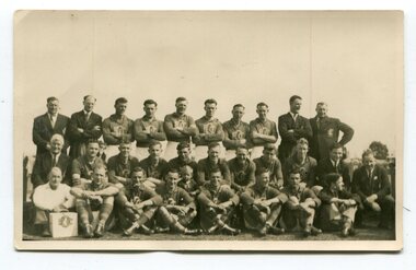
black and white photograph, 1954
The Orbost Football Club began in 1894. This photograph shows the 1954 team. The Orbost football club players were known as the Busters and wore green and gold guernseys. An Orbost football team has participated in the East Gippsland League since the early 20th century. The East Gippsland Football League in its present incarnation began in 1974 with the merger of the Gippsland Football League and the Bairnsdale District Football League .In 2003 in response to a dwindling population, the Snowy Rovers and Orbost Football Clubs were driven to merge into the Orbost Snowy Rovers Football clubs, through their many changes, have always been an important social fabric of the community. Sport is often regarded as an important part of life in rural Australia, contributing to community identity, sense of place, social interaction and good health.A black / white photograph of three rows of men wearing sports uniforms (players) and seven men in suits (officials). The fornt row is seated on the ground, the middle row on seats and the back row is standing with arms folded. a man in front row left has a case / box with the club emblem facing the camera. on back - a typed list of names and history of formation of League.sport-football orbost-football-club recreation clubs-orbost -
 Orbost & District Historical Society
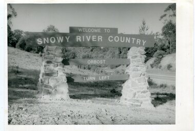
black and white photographs, second half 20th century
These photographs are pictorial records of the signs at the Orbost town entry points.Three black / white photographs. 3277.1 is a sign on stone pillars at the top of a hill - "WELCOME TO SNOWY RIVER COUNTRY ORBOST TURN LEFT". 3277.2 shows a road leading into a town. There is a sign on the left - "ORBOST" and a service station on the right. 3277.3 shows a row of newly planted trees between a road and a school.3277.1 on back - "WELCOME TO SNOWY RIVER COUNTRY - ORBOST sign - Princes Highway - Newmerella" 3277.2 on back - "East Gippsland Shire Sign on eastern approach to ORBOST., in Salisbury Street, near Orbost Secondary College" 3277.3 on back - "Tree planting in Salisbury St, Orbost in front of Orbost High School looking west towards Orbost township"photographs-orbost orbost-township-entry salisbury-street-trees town-entry road-signs-orbost -
 Orbost & District Historical Society
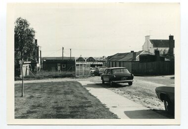
black and white photographs, C 1970s
3288.1 has been taken in Lawson Lane, Orbost, looking west from the rear of the Shire Offices. 3288.2 has been taken in Lawson Lane, Orbost, looking east from the rear of the Shire Offices.These photographs are pictorial records of the Orbost township C 1970s.Two black / white photographs showing cars parked on an unsealed road with buildings in the background.lawson-lane-orbost streets-orbost-1970s -
 Orbost & District Historical Society
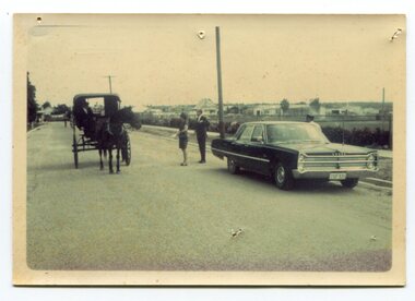
Photograph - Opening of Orbost Museum
This is a photograph of Mr & Mrs Peter Nixon about to board Kaye Lynn's covered jinker which is pulled by a horse to travel to open the Orbost Historical Society's Museum in Nicholson Street, Orbost. The original location of the Museum 1967 was in the building which is now (2022) used by the Cricket Club & Senior Citizens. The Library was also located there. Since 1994 and following the Orbost Shire's amalgamation into East Gippsland, the Library and Museum were located into the Shire's Business Centre in Ruskin Street, Orbost.photograph of an event in Orbost A b/w photograph of large car on the right hand side, two people in the centre, and a horse and sulky on the left. They are in a street.On back: Mr and Mrs Nixon are about to board Kaye Lynn's covered jinker to travel to open Orbost Historical Museum in Nicholson Street, Orbost. peter nixon mp, orbost museum, kaye lynn -
 Orbost & District Historical Society
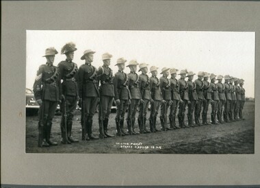
Photograph - two black and white photographs, 13th Light Horse Brigade 2 Troop C Squad
These 2 photos are of Orbost men who were part of the 13th Light Horse volunteer regiment. This military training activity continued on after W W I. These photos were taken at the training camp at Seymour, Victoria. The Orbost troop would journey to other areas for training, sometimes to Bombala, and also practice on the Orbost Rifle Range. Although not identified in these photos, George William Wraight was a leader of the Light Horse Troop in Orbost and it is his daughter Dorothy Hepburn who has donated these photos. George W Wraight was the railway-station master at Orbost from 1935. The Troop often met at the Wraight house in Tarra Street, Orbost for training. George had been in W W I in the Middle East with the Light Horse. While at the railway station at Orbost, George had an accident and suffered 2 broken legs which meant that he could no longer work there. During W W II, he worked as a recruiting officer at Sale and Warrnambool. The Troop was disbanded in the c. late 1930s.Shows evidence of military training activities, Orbost district Two sepia photographs onto grey card. Both photos show a line-up of 20 soldiers standing at attention. Size is H-22cm W-34cmIn Line Picket 2 Troop C Squad 13 LH - written on to both photos13th light horse brigade, c squad 2 troop, military training, george w wraight -
 Orbost & District Historical Society
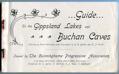
Book, The Cunninghame Progressive Association, Guide to Buchan Caves & the Gippsland Lakes, c.1900-1910
This booklet was issued as a tourist advertising/promotion for the Gippsland Lakes and Buchan Caves. It was most likely printed in the early 20th Century. This promotion also includes associated areas such as Lake Tyers, Cunninghame (Lakes Entrance), Nowa Nowa, Sale, and Bairnsdale. An early tourist promotion for East Gippsland, focussing on Melbourne tourists travelling to Sale or Bairnsdale by train, and then by steamer or coach. An example of an early tourism promotion.A booklet of 103 pages, printed in b/w. The cover is a dk. red paper with gold print, quite fragile. The book contains b/w photographs, advertisements, time tables for trains and steamers travelling through the Gippsland Lakes from Sale to Cunninghame (eg. SS JCD), also a map of the steamer route. ...Guide... To the Gippsland Lakes and Buchan Caves (Written by Frank Whitcombe, and Illustrated by H D Bulmer and N J Caire). Issued by The Cunninghame Progressive Association. J R Coate (President), Alfred Nation (Hon. Secretary), Committee - W S Barke, P Harbeck, E J Wyld, T Roadknightbuchan caves, gippsland lakes, ss j c d, tourism -
 Orbost & District Historical Society
Book - front cover, The Corringle Creek to Sydenham Inlet Coastal Reserve A RESOURCES STUDY, 1977
This 1977 Resources Study was a joint project of the Shire of Orbost & the Dept. of Crown Lands & Survey with the purpose of collating information on natural resources, pattern of public use, and constraints on future use so that management can be formulated.This report gives and understanding of the resources and management directions of coastal land in East Gippsland in 1977. A buff coloured cover with black printing and blue tape binding. 71 pages + maps/charts. THE CORRINGLE CREEK TO SYDENHAM INLET COASTAL RESERVE. A resources study with comment on the implications for management by IAN R. BROWN Research officer and PETER B. LAVERY Land Management Oficer. Coastal management Committee Victoria 1977. Published under the authority of the Coastal Management Committee by the Department of Crown Lands and Survey, Victoria 1977. Printed by James Yeates Printing, Bairnsdale 3875.corringle creek, sydenham inlet, natural resources survey -
 Ringwood and District Historical Society
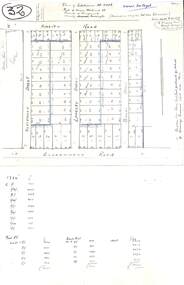
Plan, Plan of Subdivision No.11498 with handwritten costing notations - East Ringwood Central Estate c.1948
Two handwritten pages showing layout of Subdivision no 11498 with surveyor notations including property sizes and road construction cost calculations. Drainage easement 6 feet wide shaded blue.Plan of Subdivision No. 11498, Part of Crown Allotment 27, Parish of Ringwood, County of Mornington, (Certificate of Title Vol 5120 Fol 1023945). Owner Mr Vogel. Subdivision includes Knaith Road, Northwood Street, Langley Street, Bondi Street, and Government Road (later Alexandra Road), Ringwood East. G. Parsons & Sons, Licensed Surveyors, 389 Flinders Lane (Melbourne). -
 Ringwood and District Historical Society
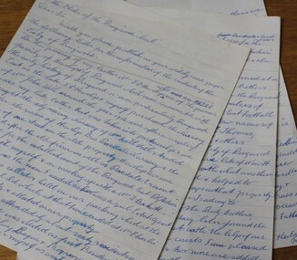
Letter, Letter written by H.C.Howship to Ringwood Mail Ringwood 1963
To the Editor of the Ringwood Mail Dear Sir, would you please publish in your widely read paper the following letter for the information of the residents of the City of Ringwood- Re the passing of my brother Mr. J.P. Howship, who was an ANZAC one of the pioneer family of Howship of Ringwood which name is connected with the early history of Ringwood or more particularly Ringwood East as the late J.P. Howship and myself purchased the Nursery of Mr. John Hill around the year 1912 and after a couple of years my late brother Bert was taken into partnership and we bought the adjoining nursery of Mr. Will Hill and traded under name Howship Bros. Rosedale Nursery and the name of one street in the old property Howship Avenue is named after the old firm as well as Rosedale Crescent. The move for the establishment of the Ringwood East station started with myself and in a meeting up with a Mr .T. Birkitt who I felt was the man I needed as he was a sub Estate Agent .A meeting was called and held in our packing shed at the end of Federal Road which at that time ended at Mr. Charlie Burdens property and abbuted (sic) on our property. This meeting was attended by about sixty residents and the late Mr. C. Wedge was elected as the first President of the Ringwood East Railway League and Progress Assoc. with Mr. T. Birkitt as Secretary and myself as assist. Secretary. This League raised the sum of about 1,600 from residents and land owners for the erection of the Ringwood East Railway Station & after the station was erected and paid for the League part was canceled and the Progress Assoc. carried on. The present Ringwood East Cricket Club was formed at meeting and the Prog .......and my three brothers Bert, Mervyn and played cricket in the Ringwood district for many years and most of us were members of the Ringwood at first and then the Ringwood East Football clubs and followed the teams for years a few names of the old players came to mind in E. Thomas , C. Weil, T. Homewood, the Pratt family and others. I might mention for the benefit of the City of Ringwood residents my eldest brother Laurie late of New Street and now living at Blairgowrie was with what was then known as Coopers Mills and designed and helped to build some of the first buildings in that property now known as Ringwood Timber & Trading Co .Also that myself and others namely the Reidy Brothers, Mr. Taylor, & L .Cleary & voluntary labour formed the tennis courts at East Ringwood with the help of our young Ladies of the time, those courts I'm pleased to say are well established and two more are added and provide good activities for the young people of the district. Also with the aid of C .Thomas, Norm Blood and others we formed the Methodist courts. From the Ringwood East Progress Association came the move to have a Health Centre for Ringwood. This was established by a good deal of enthusiastic work by some mothers after spending nearly fifty years in Ringwood watching it grow from town surrounded by orchards to a City and I must congratulate the Civic Fathers and their staff in the growth of Ringwood and the fine roads, Parks, Elderly Citizens Club and have all done a good job but why oh why have you neglected mines Road Ringwood east. Why has this road not been made the drainage there is something to be seen to be believed in such a city .The only solution is making and curbing this road & I would ask those responsible why the curbing was put down Dublin Road where there are no residents this curbing could well have solved the problem in Mines Road if used there. I recently spent a weekend with my Daughter, Mrs. Munro at the corner of Maroondah highway and Mines Road and was disgusted at the condition of Mines Road and drainage and had to air my views and suggest a trip to Mines Road by the Civic Fathers led by the Health Inspector I am yours sincerely H.C. Howship Sheila Street, Rye. (copied here verbatim)3 pages of hand written letter detailing the early history of the East Ringwood Railway and Progress Association, football, cricket and tennis clubs.. Written as a draft in 1963. -
 Ringwood and District Historical Society
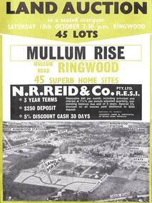
Flyer, Land Auction Advertisement, Mullum Rise, Ringwood - 1970
Double sided leaflet with aerial view of part of Ringwood showing subdivision site, terms of sale, layout of streets and allotments, and summary of local features and services.Land auction, Saturday, 10th October (1970). 45 home sites. Subdivision includes Mullum Mullum Road, Hugh Street, Rollington Drive, Cassandra Court, and Jeffrey Drive. Surveyors - R.G. Lee Pty. Ltd., 6 Davis Street, Richmond. Agents - N.R. Reid & Co., 173 Coleman Parade, Glen Waverley, (Telephone) 560 0355 A.H. 560 0361 and Safeway Centre, Boronia Road, Boronia, (Telephone) 762 1022 A.G. 795 2887, also at East Malvern and Mount Waverley. -
 Ringwood and District Historical Society
Flyer, Stillwell & Stephens Pty. Ltd, Brochure - Multiple Properties for Public Auction at Box Hill, Ringwood, Wonga Park and Clarinda - 28th November, 1934
... Road, South-east corner of Linsley Street - Timber building... Hill - Whitehorse Road, South-east corner of Linsley Street ...Seven-page brochure advertising Mortgagees' Realising Sale by Public Auction on Wednesday, 28th November, 1934 for properties at Box Hill, Ringwood, Wonga Park, and Clarinda (via Oakleigh), including photographs, property descriptions, and terms of sale.Auction Commencing at 2.15 p.m. in the Orient Line Auction Rooms, 352 Collins Street, Melbourne. Solicitors: Messrs. Madden, Butler, Elder & Graham, 406 Collins Street, Melbourne. (Agents) H.P. Knight & Co. Property Salesmen and Subidivisional Experts, 315 Collins Street, Melbourne, 'Phones: Central 10615, 10616. Attractive Residential, Orchard, and Market Garden Properties, and Public Hall and School Rooms. 1. Wonga Park via Ringwood - "Holme Bush" off Warrandyte Road, Part of Lots 14 and 15, Ringwood Orchard Estate, approximatgely three miles (north) of Ringwood Railway Station - 64 Acres. 2. 17 Bishop Street, Box Hill - timber residence. 3. Greenwood Avenue, Ringwood - On East Side, 150 feet 3 inches South of Bedford Road - timber attic residence. 4. Ringwood - Wantirna Road, South-east corner of Canterbury Road - Orchard Property of approx. 11-1/2 Acres. 5. Box Hill - Whitehorse Road, South-east corner of Linsley Street - Timber building utilised as a Public Hall and Private School. 6. Clarinda vic Oakleigh, Talbot Crescent, off Centre Road - Home on 10 acres of land. -
 Ringwood and District Historical Society
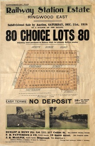
Flyer, Subdivisional Auction Sale Brochure, Railway Station Estate, Ringwood East, Vic. - 1918
Advertisement for subdivisional auction sale of 80 residential allotments on Saturday, 21st December, 1918, including terms of sale, subdivision layout, and nearby location photographs.Subdivision includes Mount Dandenong Road (incorrectly shown as White Horse Road), Dublin Road, Freeman Street, Bona Street, and Patterson Street. Local Agent - J.B. McAlpin, Telephone Ringwood 7. -
 Ringwood and District Historical Society
Flyer, Land Sale Advertisement - State School Estate, Ringwood, Victoria - 1923
The date of the flyer as circa 1920 can be estimated from the references to the (decision on) "electrification of the Croydon Railway Line" which eventually occurred in 1923, letting of tenders for the state school building which opened in 1924, and the "proposed new railway station" (East Ringwood) which opened in 1925, Advertisement for State School Estate, Ringwood - 26 residential allotments for sale near East Ringwood State School development site and 7 minutes walk from proposed new railway station (East Ringwood). Includes location map and terms of sale.Locality plan includes King Street and Government Roads (Later Everard Road, Holland Road, Purser Avenue, and Charles Street). (Agents) J.B. McAlpin, Estate Agent and Subdivisional Manager, Ringwood (Opposite Station), and F.V. Parker, Estate Agent, Main Street, Ringwood. -
 Ringwood and District Historical Society
Flyer, Land Sale Advertisement - East Ringwood Township Estates, East Ringwood, Victoria - circa 1920
The date of the flyer as circa 1920 can be estimated from the references to the (decision on) "electrification of the Croydon Railway Line" which eventually occurred in 1923, letting of tenders for the state school building which opened in 1924, and the "proposed new railway station" (East Ringwood) which opened in 1925, Advertisement for three retail and residential allotment land sales in East Ringwood Township including maps showing layout of subdivisions. Township Estate, State School Estate, and East Ringwood Station Estate.Subdivision plans include Mount Dandenong Road, Grey Street, Eastfield Road, King Street, Everard Road, Holland Road, Purser Avenue, and Charles Street. (Agents) Spencer Jackson, Subdivider & Homebuilder, 341 Collins Street, Melbourne, Phones: M2327 (3 lines), also at Dromana, Phone 65. -
 Ringwood and District Historical Society
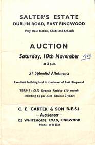
Flyer, Land Sale Auction Brochure, Salter's Estate, East Ringwood, Vic. - 1956
Folded single page advertising auction of allotments on Saturday, 10th November (1956), including layout of subdivision and terms of sale.Subdivision includes Railway Avenue, Nicholson Street, Althol Grove (later Morcom Avenue), Illoura Avenue, Tweed Street, Merry Street, and Dublin Road. (Agent) C.E. Carter & Son R.E.S.I., Auctioneer, 126 Whitehorse Road, Ringwood, Phone WU6024. -
 Ringwood and District Historical Society
Flyer, Land Sale Advertisement - Sunbeam Estate, East Ringwood, Victoria - circa 1930
Folded double-sided page advertising private sale of 48 residential allotments, with location map, terms of sale, and details of local features and services. Locality plan includes Holland Road, Everard Road, Sunbeam Avenue, Mount Dandenong Road, and Lilydale Road (later Old Lilydale Road). (Agents) Phillips & Nicholson, 59 Swanston Street, Melbourne, (Phone) Central 10907, in conjunction with C.E. Carter, Bank Chambers, Main Street, Ringwood, Telephone Ringwood 24. -
 Ringwood and District Historical Society
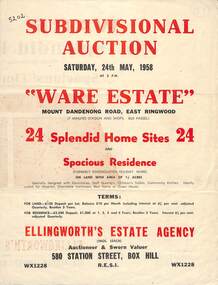
Flyer, Subdivisional Auction Sale Brochure, Ware Estate, East Ringwood, Vic. - 1958
Folded double-sided advertisement for auction of 24 home sites and existing residence on Saturday, 24th May, 1958, including locality map, subdivision layout, terms of sale, and summary of local facilities and services.Subdivision includes Mount Dandenong Road, Ware Crescent, Davey Drive, and Grey Road (later Grey Street). Timber residence included in the subdivision was formerly Ware Kindergarten Holiday Home. (Agent) Ellingworth's Estate Agency, 580 Station Street, Box Hill - (Phone) WX1228. -
 Ringwood and District Historical Society
Memorabilia - History Timeline, Byways Homestead, Coolooli Estate, Ringwood East, 1878-2008
Development of Coolooli Estate with property titles and leaflets for the sale of "Byways" homestead, 4 Byways Drive, Ringwood East. Also the house at 9 Walhalla Drive, Ringwood East. Correspondence between David Best and Richard Carter re the estate. Coolooli subdivision includes lots fronting Isabel Avenue, Byways Drive, Coolooli Court, Walhalla Drive and Cleland Street. Property Titleholders include: George Blood William Chelman Thurgood Frederick Deine Laurie Arthur Wigley Charles Patterson Mary Aphra Patterson John Douse Langley August DiGilio Kenneth Ross Landy Mervyn MacPherson Brewer Richard Blennenhassett Best Jessie May Cleland John Brian Little Robert William Campbell Lynette Marie Campbell Lorraine Ruby Campbell David Charles Nicholls Barbara Janette Nicholls Ian Finlay Packer Nellie Packer -
 Orbost & District Historical Society
calendar, Old Views of Gippsland, 2000
... McLeod Street, Bairnsdale, East Gippsland, Victoria... street of Lindenow. It contains early photographs of East ...The East Gippsland Historical Society has produced an annual calendar 'Old Views of Gippsland' since 2003. This item is a useful reference for the history of Gippsland.A 2001 stapled calendar, titled "Old Views of Gippsland".On the front is a black/white photograph of the main street of Lindenow. It contains early photographs of East Gippsland, one for each month. December has a photograph of Nicholson street in Orbost and October has a photograph of the construction of the East Gippsland railway at the Newmerella cutting. calendar photographs-gippsland -
 Orbost & District Historical Society
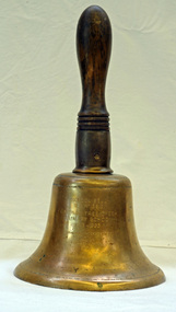
Functional object - Bell, hand-held, Early 20th century, c.1900s
The settlement of Cabbage Tree Creek is located on the Princes Highway, 27 km east of Orbost in East Gippsland. The creek, which flows through undulating forest, takes its name from the patches of Cabbage Fan palms growing along its course. A school commenced classes in 1913, but enrolment was small and at times the school operated part time with several other small schools in the area. The school building served as a hall for the district. About 1946 two sawmills commenced operations at Cabbage Tree Creek, and the Forests Commission ranger was stationed in the area. The increased population allowed the school to have more teachers and make improvements. In 1953, a new prefabricated building was erected on a new site. However, by the 1970s employment in the timber industry was unstable and the population decreased. By 1974 the school again had only one teacher and eventually closed in 1993 to amalgamate with the Orbost primary School in Ruskin Street, Orbost. (Ref. VictorianPlaces)The school bell is a signal that tells a school's students when it is time to go to class in the morning and when it is time to change classes during the day as well as when students are dismissed from school. In most schools today it will be a tone, siren, electronic bell sound, a series of chimes, or music played over an intercom but often still called "the school bell". This item reflects the history of Cabbage Tree Creek as well as the technological changes in the school system.Brass bell with incised double lines on bottom edge and top near handle, featuring descriptive notation on front face. Bell has long wooden handle shaped and incised with four lines at base before brass housing with singular screw holding handle in place. Object is showing signs of wear, with blackened handle and patches of green oxidisation.SCHOOL BELL / SS No 3812 / CABBAGE TREE CREEK / PRIMARY SCHOOL / 1913-1993 / FORMALLY INCORPORATED / INTO / ORBOST / PRIMARY SCHOOL / 1994cabbage tree, east gippsland, cabbage tree creek, cabbage tree creek primary school, orbost primary school, school bells