Showing 6712 items
matching gully
-
 Marysville & District Historical Society
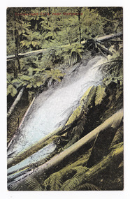
Postcard (item) - Colour tinted postcard, Nicholas John Caire, Cumberland Falls near Marysville, 1858-1918
One of a series of postcards of photographs taken by socialite photographer Nicholas John Caire. N.J. Caire had a great love for the area and in the late 1800's took many photographs of Marysville and its surrounds.One of a series of postcards of photographs taken by socialite photographer Nicholas John Caire. N.J. Caire had a great love for the area in and surrounding Marysville and in the late 1800's took many photographs of Marysville and its surrounds. N.J. Caire was born in 1837 in Guernsey. He arrived in Adelaide about 1860 along with his parents who encouraged his early interest in photography. He opened a studio in Adelaide in 1867 after traveling extensively throughout the Gippsland taking photographs. After marrying in 1870 he moved to Talbot in Victoria until 1876 when he opened a studio in the Royal Arcade in Melbourne. After 1885 N.J. Caire gave up his city work and made his home in South Yarra and devoted the rest of his life to outdoor photography, specializing in the bush, the gullies and the mountains of south-eastern Victoria. POST CARD Printed in Australia This space may be used for Correspondence/ within the Commonwealth without/ extra postage THIS SPACE FOR NAME AND/ ADDRESS Stamp/ Heremarysville, victoria, nicholas john caire, postcard, souvenir, cumberland falls -
 Marysville & District Historical Society
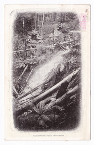
Postcard (item) - Black and white postcard, Nicholas John Caire, Cumberland falls, Marysville, 1858-1918
One of a series of postcards of photographs taken by socialite photographer Nicholas John Caire. N.J. Caire had a great love for the area and in the late 1800's took many photographs of Marysville and its surrounds.One of a series of postcards of photographs taken by socialite photographer Nicholas John Caire. N.J. Caire had a great love for the area in and surrounding Marysville and in the late 1800's took many photographs of Marysville and its surrounds. N.J. Caire was born in 1837 in Guernsey. He arrived in Adelaide about 1860 along with his parents who encouraged his early interest in photography. He opened a studio in Adelaide in 1867 after traveling extensively throughout the Gippsland taking photographs. After marrying in 1870 he moved to Talbot in Victoria until 1876 when he opened a studio in the Royal Arcade in Melbourne. After 1885 N.J. Caire gave up his city work and made his home in South Yarra and devoted the rest of his life to outdoor photography, specializing in the bush, the gullies and the mountains of south-eastern Victoria. Victorian one penny postage stamp Post Card The Address to be written on this side This space may be used for Correspondence/ within the Commonwealth at 1d rate./ Foreign, charged ordinary letter rate. AFFIX STAMP/ HERE Dear Mum/ Will you bring me/ over some/ milk. I cannot/ get any here./ Love to all/ from all/ Hilda Mrs Gregory/ Bay View Hotel/ Frankstonmarysville, victoria, nicholas john caire, postcard, souvenir, cumberland falls -
 Marysville & District Historical Society
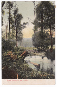
Postcard (item) - Colour postcard, Nicholas John Caire, Brook Scene at Marysville, 1906
One of a series of postcards of photographs taken by socialite photographer Nicholas John Caire. N.J. Caire had a great love for the area and in the late 1800's took many photographs of Marysville and its surrounds.One of a series of postcards of photographs taken by socialite photographer Nicholas John Caire. N.J. Caire had a great love for the area in and surrounding Marysville and in the late 1800's took many photographs of Marysville and its surrounds. N.J. Caire was born in 1837 in Guernsey. He arrived in Adelaide about 1860 along with his parents who encouraged his early interest in photography. He opened a studio in Adelaide in 1867 after traveling extensively throughout the Gippsland taking photographs. After marrying in 1870 he moved to Talbot in Victoria until 1876 when he opened a studio in the Royal Arcade in Melbourne. After 1885 N.J. Caire gave up his city work and made his home in South Yarra and devoted the rest of his life to outdoor photography, specializing in the bush, the gullies and the mountains of south-eastern Victoria. POST CARD This Space may be used for Correspondence. (FOR ADDRESS ONLY) Postmark/ Geelong/ 22/ Rest is illegible Glad to know you/ are keeping better/ & trust you will go/ on so doing accept/ love & best wishes/ for a happy Xmas/ we will be all/ thinking of you/ Yours M.P. Philip Mip Rittocto/ "Hospital"/ Lt Ryrie St/ Geelongmarysville, victoria, nicholas john caire, brook scene, souvenir, postcard -
 Marysville & District Historical Society
Document (item) - Gold Mine Prospectus, H.D. McKie, Prospectus of the New Golden Bower & Star Gold M.Co, 1896
A copy of the Prospectus of the New Golden Bower & Star Gold M.Co. near Marysville in Victoria.A copy of the Prospectus of the New Golden Bower & Star Gold M.Co. near Marysville in Victoria. The Golden Bower gold mine was a quartz reef mine. William Edward Chester discovered the Golden Secret gold vein which became part of the Golden Bower Mine at Chesterville near Donovans Creek on the Cumberland goldfield which he mined with George Locke until the late 1930s. new golden bower & star gold m.co., donovan's creek, nuggety gully creek, yarra track, marysville, victoria, share prospectus, upper yarra track, wood's point, victoria mount morgan gold mining co., british mount morgan mine, mr white, reefton turnoff, santa claus reef, bear's creek, mr r ely, bear's creek reef, big river, mr feely, new star reef, golden bower reef, a1 mining co, mr r m lee, locke's no.1 extended gold mining company, mr q dick -
 Marysville & District Historical Society
Photograph (Item) - Black and white photograph, Fernshaw, c1900
An early black and white photograph taken at Fernshaw.An early black and white photograph taken at Fernshaw. Fernshaw was a rural township 63 km north-east of Melbourne and 10 km north-east of Healesville. Situated on the Watts River, near where a log had fallen making a convenient crossing, Fernshaw was settled in the 1860s. It provided good country for orchards and berry growing. The location was at the foot of Blacks Spur, with Mounts Juliet and Mondah rising on either side, providing spectacular scenery. There were nearby fern gullies giving rise to the name – ‘shaw’ is old English for thicket or wood. By 1875 Fernshaw had a post office (1865), two hotels, a school (1871) and stores. It was famed for its beauty, attracting tourists. In 1886 the Melbourne and Metropolitan Board of Works began work on the Watts River water catchment scheme – later to become Maroondah – and the Board obtained approval for the catchment country to be reserved and kept free of settlement. This required the removal of the Fernshaw township, which was completed by about 1890. The area was described in the 1903 Australian handbook:ARMSTRONG COLLECTION 42 STATION STREET/ SANDRINGHAM 3191/ TEL. (03) 9521 5442/ IAN M.L. ARMSTRONG OAMfernshaw, healesville, watts river, orchard, berry orchard, blacks spur, black spur, mount juliet, mount mondah, maroondah dam, victoria -
Marysville & District Historical Society
Document (Item) - Book extract, John (Jack) Cato, Nicholas John Caire of Melbourne-The Story of the Camera in Australia, 1955
An account of the life of Nicholas John Caire extracted from the book The Story of the Camera in Australia.An account of the life of Nicholas John Caire extracted from the book The Story of the Camera in Australia. Nicholas John Caire was born in 1837 in Guernsey. He arrived in Adelaide about 1860 along with his parents who encouraged his early interest in photography. He opened a studio in Adelaide in 1867 after traveling extensively throughout the Gippsland taking photographs. After marrying in 1870 he moved to Talbot in Victoria until 1876 when he opened a studio in the Royal Arcade in Melbourne. After 1885 Nicholas John Caire gave up his city work and made his home in South Yarra and devoted the rest of his life to outdoor photography, specializing in the bush, the gullies, and the mountains of south-eastern Victoria. nicholas john caire, john (jack) cato, the story of the camera in australia -
 Marysville & District Historical Society
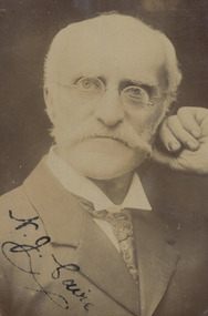
Photograph (Item) - Black and white photograph, 1900s
A digital copy of a black and white portrait of Nicholas John Caire.A digital copy of a black and white portrait of Nicholas John Caire. Nicholas John Caire was born in 1837 in Guernsey. He arrived in Adelaide about 1860 along with his parents who encouraged his early interest in photography. He opened a studio in Adelaide in 1867 after traveling extensively throughout the Gippsland taking photographs. After marrying in 1870 he moved to Talbot in Victoria until 1876 when he opened a studio in the Royal Arcade in Melbourne. After 1885 Nicholas John Caire gave up his city work and made his home in South Yarra and devoted the rest of his life to outdoor photography, specializing in the bush, the gullies, and the mountains of south-eastern Victoria. nicholas john caire -
 Marysville & District Historical Society
Photograph (Item) - Black and white photograph, 1900s
A digital copy of a black and white portrait of Nicholas John Caire.A digital copy of a black and white portrait of Nicholas John Caire. Nicholas John Caire was born in 1837 in Guernsey. He arrived in Adelaide about 1860 along with his parents who encouraged his early interest in photography. He opened a studio in Adelaide in 1867 after traveling extensively throughout the Gippsland taking photographs. After marrying in 1870 he moved to Talbot in Victoria until 1876 when he opened a studio in the Royal Arcade in Melbourne. After 1885 Nicholas John Caire gave up his city work and made his home in South Yarra and devoted the rest of his life to outdoor photography, specializing in the bush, the gullies, and the mountains of south-eastern Victoria. N.J. Cairenicholas john caire -
 Marysville & District Historical Society
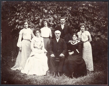
Photograph (Item) - Black and white photograph, 1900s
A digital copy of a black and white photograph of Nicholas John Caire, his wife Louisa, and their five adult children.A digital copy of a black and white photograph of Nicholas John Caire, his wife Louisa, and their five adult children. Nicholas John Caire was born in 1837 in Guernsey. He arrived in Adelaide about 1860 along with his parents who encouraged his early interest in photography. He opened a studio in Adelaide in 1867 after traveling extensively throughout the Gippsland taking photographs. After marrying Louisa Master in 1870 he moved to Talbot in Victoria until 1876 when he opened a studio in the Royal Arcade in Melbourne. After 1885 Nicholas John Caire gave up his city work and made his home in South Yarra and devoted the rest of his life to outdoor photography, specializing in the bush, the gullies, and the mountains of south-eastern Victoria. nicholas john caire, louisa master, louisa caire -
 Marysville & District Historical Society
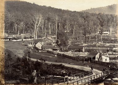
Photograph (Item) - Black and white photograph, Nicholas John Caire, 1883
An early black and white photograph of the township of Marysville in Victoria.An early black and white photograph of the township of Marysville in Victoria. This photograph of Marysville was taken by Nicholas John Caire in 1883. Nicholas John Caire was born in 1837 in Guernsey. He arrived in Adelaide about 1860 along with his parents who encouraged his early interest in photography. He opened a studio in Adelaide in 1867 after traveling extensively throughout the Gippsland taking photographs. After marrying in 1870 he moved to Talbot in Victoria until 1876 when he opened a studio in the Royal Arcade in Melbourne. After 1885 Nicholas John Caire gave up his city work and made his home in South Yarra and devoted the rest of his life to outdoor photography, specializing in the bush, the gullies, and the mountains of south-eastern Victoria. nicholas john caire, marysville, victoria -
 Marysville & District Historical Society
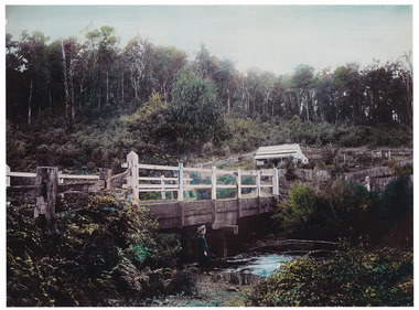
Photograph (Item) - Colour tinted photograph, 1878-1904
A copy of an early colour tinted photograph of a wooden bridge in Marysville in Victoria.A copy of an early colour tinted photograph of a wooden bridge in Marysville in Victoria. This photograph was taken by Nicholas John Caire between 1878 and 1904. Nicholas John Caire was born in 1837 in Guernsey. He arrived in Adelaide about 1860 along with his parents who encouraged his early interest in photography. He opened a studio in Adelaide in 1867 after traveling extensively throughout the Gippsland taking photographs. After marrying in 1870 he moved to Talbot in Victoria until 1876 when he opened a studio in the Royal Arcade in Melbourne. After 1885 Nicholas John Caire gave up his city work and made his home in South Yarra and devoted the rest of his life to outdoor photography, specializing in the bush, the gullies, and the mountains of south-eastern Victoria. nicholas john caire, marysville, victoria -
 Marysville & District Historical Society
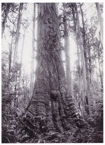
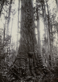
Photograph (item) - Black and white photograph, Nicholas John Caire, 1878-1904
An early black and white photograph of a Cumberland Valley giant tree.An early black and white photograph of a Cumberland Valley giant tree. This photograph was taken by Nicholas John Caire between 1878 and 1904. Nicholas John Caire was born in 1837 in Guernsey. He arrived in Adelaide about 1860 along with his parents who encouraged his early interest in photography. He opened a studio in Adelaide in 1867 after traveling extensively throughout the Gippsland taking photographs. After marrying in 1870 he moved to Talbot in Victoria until 1876 when he opened a studio in the Royal Arcade in Melbourne. After 1885 Nicholas John Caire gave up his city work and made his home in South Yarra and devoted the rest of his life to outdoor photography, specializing in the bush, the gullies, and the mountains of south-eastern Victoria. big tree, mountain ash, cambarville, victoria, photograph, cumberland valley, nicholas john caire -
 Marysville & District Historical Society
Photograph (Item) - Black and white photograph, Nicholas John Caire, 1878-1904
Shows two men measuring around the base of a Cumberland Valley giant tree. An early black and white photograph of a Cumberland Valley giant tree. This photograph was taken by Nicholas John Caire between 1878 and 1904. Nicholas John Caire was born in 1837 in Guernsey. He arrived in Adelaide about 1860 along with his parents who encouraged his early interest in photography. He opened a studio in Adelaide in 1867 after traveling extensively throughout the Gippsland taking photographs. After marrying in 1870 he moved to Talbot in Victoria until 1876 when he opened a studio in the Royal Arcade in Melbourne. After 1885 Nicholas John Caire gave up his city work and made his home in South Yarra and devoted the rest of his life to outdoor photography, specializing in the bush, the gullies, and the mountains of south-eastern Victoria. big tree, mountain ash, cambarville, victoria, photograph, cumberland valley, nicholas john caire -
 Marysville & District Historical Society
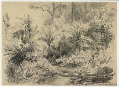
Artwork, other (Item) - Pencil Sketch, Louis Buvelot, Fernshaw 17.2.83, 1883
A copy of an early pencil sketch of Fernshaw in Victoria.A copy of an early pencil sketch of Fernshaw in Victoria by Louis Buvelot. Louis Buvelot ( 1814–1888), born Abram-Louis Buvelot, was a Swiss landscape painter who lived 17 years in Brazil and following 5 years back in Switzerland stayed 23 years in Australia, where he influenced the Heidelberg School of painters. Arriving in Melbourne in February 1865, after leaving the cold of Switzerland, which was impacting on his health, for the warmth of Australia, Buvelot was in business as a photographer in Bourke Street for a year but soon resumed his painting. He lived in Melbourne for a number of years before moving to Fitzroy. The National Gallery of Victoria purchased two of his paintings and he continued painting until his death in 1888. He was buried at the Boroondara Cemetery, where a large monument was erected in his memory. Fernshaw was a rural township 63 km northeast of Melbourne and 10 km northeast of Healesville. Situated on the Watts River, near where a log had fallen making a convenient crossing, Fernshaw was settled in the 1860s. It provided good country for orchards and berry growing. The location was at the foot of Blacks Spur, with Mounts Juliet and Mondah rising on either side, providing spectacular scenery. There were nearby fern gullies giving rise to the name – ‘shaw’ is old English for thicket or wood. By 1875 Fernshaw had a post office (1865), two hotels, a school (1871), and stores. It was famed for its beauty, attracting tourists. In 1886 the Melbourne and Metropolitan Board of Works began work on the Watts River water catchment scheme – later to become Maroondah – and the Board obtained approval for the catchment country to be reserved and kept free of settlement. This required the removal of the Fernshaw township, which was completed by about 1890.Fernshaw 17.2.83louis buvelot, fernshaw, victoria, national gallery of victoria, switzerland, boroondara cemetery, kew cemetery, artist -
 Marysville & District Historical Society
Painting (Item) - Oil painting, Isaac Whitehead, A spring morning near Fernshaw 1880, 1880
A copy of an early oil painting of Fernshaw in Victoria.A copy of an early oil painting of Fernshaw in Victoria by Isaac Whitehead. Isaac Whitehead (1819–1881) was an Irish-Australian artist who worked in watercolour and pastel. He was also a picture framer and art promoter. It is believed that Isaaz Whitehead emigrated to Australia with his family in either 1853 or 1858. Isaac Whitehead died at his home 50 Punt Road, Prahran, Melbourne, on 21 April 1881. Isaac Whitehead had established himself as the foremost picture framer in Melbourne by 1860, known for his highly ornate frames with floral decorations. Among the clients of his framing business were Louis Buvelot, Nicholas Chevalier, and Eugene von Guérard. In his own paintings, he painted a number of scenes of the forests of Gippsland, Victoria. His work focused on the rich landscapes with trees and ferns, with a high degree of botanical detail. His work won him two medals and his work was posthumously exhibited at 1884 Victorian Jubilee Exhibition, the 1886 London Colonial and Indian Exhibition, and the 1888 Melbourne Centennial Intercolonial Exhibition. Fernshaw was a rural township 63 km northeast of Melbourne and 10 km northeast of Healesville. Situated on the Watts River, near where a log had fallen making a convenient crossing, Fernshaw was settled in the 1860s. It provided good country for orchards and berry growing. The location was at the foot of Blacks Spur, with Mounts Juliet and Mondah rising on either side, providing spectacular scenery. There were nearby fern gullies giving rise to the name – ‘shaw’ is old English for thicket or wood. By 1875 Fernshaw had a post office (1865), two hotels, a school (1871), and stores. It was famed for its beauty, attracting tourists. In 1886 the Melbourne and Metropolitan Board of Works began work on the Watts River water catchment scheme – later to become Maroondah – and the Board obtained approval for the catchment country to be reserved and kept free of settlement. This required the removal of the Fernshaw township, which was completed by about 1890.isaac whitehead, fernshaw, victoria, louis buvelot, nicholas chevalier, eugene von guerard, gippsland, victorian jubilee exhibition, london colonial and indian exhibition, melbourne centennial intercolonial exhibition, watts river, healesville, blacks spur, mount juliet, mount mondah -
 Marysville & District Historical Society
Photograph (Item) - Black and white photograph, Fred Kruger, Scene on the Watts River near Fernshaw, Unknown
A copy of a black and white photograph on the Watts River near Fernshaw in Victoria.A copy of a black and white photograph on the Watts River near Fernshaw in Victoria taken by Fred Kruger. Fred Kruger (born Johan Friedrich Carl Kruger, 18 April 1831 – 15 February 1888) was a German-born photographer noted for his early photography of landscape and indigenous peoples in Victoria, Australia. Fernshaw was a rural township 63 km northeast of Melbourne and 10 km northeast of Healesville. Situated on the Watts River, near where a log had fallen making a convenient crossing, Fernshaw was settled in the 1860s. It provided good country for orchards and berry growing. The location was at the foot of Blacks Spur, with Mounts Juliet and Mondah rising on either side, providing spectacular scenery. There were nearby fern gullies giving rise to the name – ‘shaw’ is old English for thicket or wood. By 1875 Fernshaw had a post office (1865), two hotels, a school (1871), and stores. It was famed for its beauty, attracting tourists. In 1886 the Melbourne and Metropolitan Board of Works began work on the Watts River water catchment scheme – later to become Maroondah – and the Board obtained approval for the catchment country to be reserved and kept free of settlement. This required the removal of the Fernshaw township, which was completed by about 1890.fernshaw, watts river, victoria, fred kruger, photograph -
 Eltham District Historical Society Inc
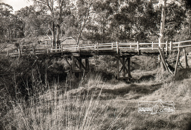
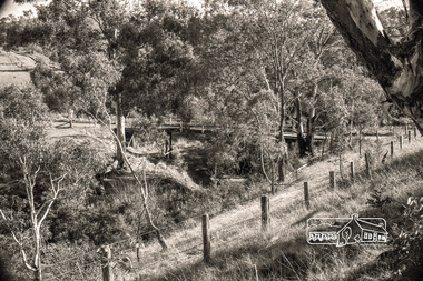
Negative - Photograph, Russell Yeoman, Lintons Bridge over Arthurs Creek, c.1970
Now demolished.Roll of 35mm black and white negative film, 4 of 7 strips Associated printIlford HP4bridge, bridges, arthurs creek, doctors gully road, lintons bridge, nutfield -
 Eltham District Historical Society Inc
Photograph, Russell Yeoman, Lintons Bridge over Arthurs Creek, c.1970, 1970c
Now demolished.Roll of 35mm black and white negative film, 4 of 7 stripsIlford HP4bridge, bridges, arthurs creek, doctors gully road, lintons bridge, nutfield -
 Federation University Historical Collection
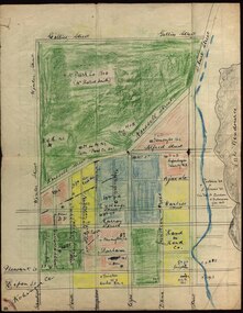
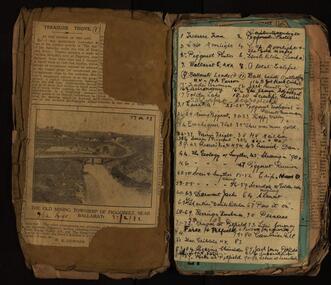
Booklet - Exercise Book, Sebastopol Mines and Socialism
Sebastopol is a suburb of Ballarat..1) Black notebook with red spine .2) hand drawn map showing location of Sebastopol minesHandwritten pageswilliam robertson, new lady don company, kohinor company, leviathon company, newington, copenhagen company, hand in hand company, tannery ground, ballarat freehold company, rough and ready company, park company, inkerman alluvial lead, band & albion consols, gravel pits lead, robert gay, sebastopol mines, ballarat east, alluvial, dalton's flat, canadian gully, red streak, montezuma company, great republic company, golden point, gravel pits, j. hardy, scott's boot shop, lady don company, cgt -
Federation University Historical Collection
Book, Glenfine South and South Berry Journal
This Book is associated with former Ballarat School of Mines Student Richard Squire (1875-1876). Gift of the Squire FamilyGreen water marked linen covered journal with maroon spine with red feint lined blue pages. Label on front cover is cream with black printing JOURNAL with handwritten DATA RISIS GLENFINE SOUTH -SOUTH BERRY G.S & S.B Hand written in black and red ink. Plan in back with scale 20 chains to one inch - Has an index. Handwritten on title page in black ink Address of sawmiller T. J. Brown, Mount Rowan D. W. Hambly 317 Ligar St, Ballarat J. Freeman, C/O Mrs H Simons, Lynch St, Footscray Sleemans Prescription for the bladder in 19009 Mixture No 55983 Tabloids No 55982glenfine south, south berry, sleemans, mining, gold mining, glenfine consols, reef, weights of quartz, blacksmiths tools, australian and eagle, davies south east reef drive, brawns, eaglehawk junction, simons letter, machinery, puddlng plant, poppet heads, winding plant, creswick, mosquito creek, frenchmans gully, spring hill, a. h. welsh, squire, petticoat gully -
 Federation University Historical Collection
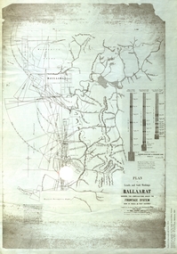
Plan, Plan of Leads and Gold Workings at Baallarat Shewing the Complications Under the Frontage System, 1863, 1863
Facsimile of a plan held by the Public Record Office Victoria. Facsimile of a plan of Ballarat showing leads, gold workings an dthe frontage system.ballarat, mining, inkermann lead, golden point lead, robert davidson, terrible lead, white horse lead, frenchman's lead, little magpie lead, milkmaid's lead, woolshed lead, nuggety lead, blackman's lead, canadian lead, sailor's gully lad, nightingale lead, malakoff lead, black hill gully, pennyweight flat, black hill, winter's pre-emptive right, nelson company, great extended, great republic lead, cgt -
 Federation University Historical Collection
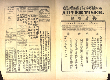
Newspaper, The English and Chinese Advertiser, 28 November 1857, 28/11/1857
Four page Ballarat newspaper written in English and Chinesechinese, ballarat, robert bell, ballarat hospital, c. morris, undertaker, samuel sloan, euang cgung and co., william henry foster, j. howell, t. dean, george gray, c.h. herrring, thomas slater, r. davidson, j.s. robertson, j.r. grundys, j.t. jackson, john t. shew, william t. jackson, w.f. heinecke & co, thomas lang, m. jordain, dentist, j.j. baird, chinese protector, bakery hill, american sgtove depot, a.a. surplice, tobacco, carpenters, john t. shaw, dead horse gully, boots and shoes -
Federation University Historical Collection
Newspaper, ANZAC Centenary newspaper features, 2015, 25/04/2015
The Centenary of the ANZAC landing of Gallipoli was marked in 2015. .1) Herald Sun Gallipoli 100-year Anniversary - The Legend Begins. Includes information on Gallipoli, Gallipoli landing, Lemnos, VC Winners, William Dunstan, Bigali, The Nek, Indigenous soldiers, Lone Pine, Gallipoli Retreat Images include: Gallipoli, William Birdwood, Harold Walker, Winston Churchill, Ian Hamilton, John Fisher, William Throsby Bridges Otto Linden von Sanders, Herbert Asquith, Sinclair MacLagan, Mehit Sefik, Mastafa Kermal, nurses on Lemnos, Alexander Burton, Bigali, Turkey, Keith Murdoch, Charles Bean, Joe Stratford, Frank Loud, Thomas Ford, Leslie Boyce, Raymond Brownell, Alfred Lovett, Leonard Lovett, Frederick Amos Lovett, Herbert Stahle Lovett, Cyril Brudenell White, Minyip .2) ANZAC Day 2015 Supplement from The Age. The supplement includes information on Australia's compulsory cadet training, Wireless telegraphists, horses .3) The Age ANZAC centernary Galipoli Tribute, 2015. Eight page broad sheet with amazing stories from the front line. Includes a listing of all those who lost their lives on the Gallipoli Peninsula, timeline of the Gallipoli landing, information on Douglas Barrett-Lennard, William Throsby Bridges, Alan Dudley Henderson, James Charles Martin, Arthur Harold Jopp, John Simpson Kirkpatrick, Cecil Anthony McAnulty, Laurence W. Street, Alfred Shout, Joseph Stratford, Alexander Stewart Burton, Alfred Hearpsgallipoli, anzac centenary, gallipoli landing, walker's ridge, pope's hill, quinn's post, lone pine, pine ridge, shrapnel gully, the sphinx, maclaurin's hill, monash valley, plugge's plateau, dardenells, keith murdoch, charles bean, cadets, compulsory cadet training -
 Federation University Historical Collection
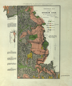
Plan, Durham Lead, 1870
Geological Map of portions of Durham Lead. durham lead, reginald a.f. murray, plan, garibaldi, garibaldi company, geology, chryseis company, hardies hill, city of manchester company, williamson's creek, south grenville company, enfield company, pioneer company, duke of northumberland company, monmowth gully, extinct volcano crater, mount mercer basalt -
Federation University Historical Collection
Book, Historic Sites Survey: North Central Study Area, 1979, 1979
The North Central Study Area included the Shires of Avoca, Bet Bet, east Loddon, Goulburn, Untly, Kara Kara, Korong, Maldon, Marong, Metcalfe, McIvor, Newstead, Strathfieldsaye, Stawell, Talbot, Clunes, Tullaroop and Waranga. 153 page book with white plastic binding. It is an historic sites survey for the North Central Study Area commissioned by the Land Conservation Council, the Ministry for COnservation and the Australian Heritage Commission. castlemaine, mount alexander goldfield, maldon, percydale, warrenmang, moliagul, tarnagulla, stuart mill, the whipstick, whroo, rushworth, graytown ironbark forest, st arnoaud, new bendigo, landsborough, inglewood, kurting, wedderburn, wehla, kooroora, langham flat, mcintyre, rheola, diamond hill, fosterville, coliban water works, green gully, newstead, muckleford forest, costerfield, graytown, bailieston, waranga irrigaiton system, eucalyptus distillery, mia mia bridge, korokubeal township researce, concegella slate quarry, chewton, fryerstown, kingower, timor, talbot, majorca, carisbroook, clunes, st arnaud, taradale, icomos, dunolly, limestone, castlemaine slate quarry, harcourt granite, taradale railway viaduct, loddon united waterworks trust, gouldburn weir, carisbrook lock-up, history of tree planting in streets, history of public reserves, r.u. nicholls nurseryman, thomas lang, francis moss, ballarat botanical gardens, ballarat school of mines botanical gardens, lake wendouree, victoria park, ballarat, muont holled smith, ballaarat old cemetery planting, eastern oval, ballarat east botanical gardens, ballarat east town hall gardens, eureka stockade reserve, ballarat observatory plantings, yarrowee creek plantings, yarrowee bluestone channels, ballarat woollen mill, band and albion mullock heap, black hill plantings, yarrowee creek channels, canadian creek channel, specimen vale channel, poverty point reserve, union jack reserve buninyong, imperial mine, buninyong, victoria street plantings, bridge mall, sturt street gardens, ballarat avenue of honour plantings, white flat oval plantings, camp street, elms, burnt creek -
Federation University Historical Collection
Reports, Unidentified Mammal Report, 1970-1990, 1970-1990
The folder or correspondence is the result of a Freedom of Information request made to the Department of of Conservation, Forests and Lands in 2011. The folder was collected for research being conducted by David Waldron.Folder of reports relating to "Big Cats", Thylacines, and other large predators sightings australian mythical animals collection, david waldron, thylacine, sassafras, peter monhorst, jodie hoey, kelvin smith, traralgon south, gormondale, bridgewater, g. mcclure, whorouly, albury, jim walker, andrea westcott, john dawson, nicole walsh, grampians, eddy scott, talbot, lancefield, kalorama, inglewood, gavin cerini, dereel, rosemary fernandez, brian walters, alexandra, unidentified mammel, romsey, bill butterworth, flowerdale, bob hoare, trafalgar, lyn demopolis, broadford, green gully, ian weir, noel pascoe, bruce carter, mount stirling, andrea cooper, stawell, yvonne shepherd, red hills, halls gap, jill reid, puma, w.r.c. hill, caelli -
Federation University Historical Collection
Book, Maldon Historic Reserve Management Plan, 1989, 1989
This book was prepared by the Royal Botanic Gardens, Mebourne Soft covered report of 83 pages, including 10 folded leaves of plates , and 11 maps (some coloured). maldon, geology, flora, vermin, parkin's reef, derby hill, beehive reef, long gully, union hill, mount tarrengower, eaglehawk gully, porcupine flat, neggetty range, peg leg gully, sandy creek, smiths creek, landscape -
 Federation University Historical Collection
Book - Scrapbooks, William RObertson, Newsclips written by William Robertson, c1930-c1948, c1930-c1948
Small brown covered scrapbook with newsclipping written by William Robertson, and his handwritten corrections to the articles. Newsclips include poetry and articles on: Piggoreet, Captain Moonlight, Devil's Kitchen, Ballarat East Australian Natives' Association, A Total Eclipse, Ballarat Leads, Joe Mack Cricket, Trade Unionism, Jack Hewitt of Piggoreet, Astronomy, Golden Lake, Scientific Shearers, Eureka, Piggoreet Geological, Piggoreet Mining, Happy Valley, Exchequer Flat, Fairy's Fright, H.V. Mailboy, Shearers, Creswick, Geology of Smythesdale, Shearing in the 1890s, Piggoreet reunion, Scarsdale and Smythesdale, Scarsdale to Golden Lake, Derwent Jacks, Shanties Devil's Kitchen, Berringa Bushmen, Perseus, Kruger at Pitfield, Fires and Pitfield, Football Memories, Cambrian Hill, Theo Gribble, Jack Jones Pitfield, Risks at Pitfield, Superstition, Scarsdale, death notice for William Robertson's mother.On cover: "Wm Robertson 10 Young Street Ballarat East"andrew christie, mrs nimon, william christie, alec christie, grand trunk, cape clear, donald mclean's, alchemist co, john lynch, golden belt lead, paddy webb, annie rooney, kruger hanging, pitfield, boer war, napoleons, cambran hill, hiscocks, john winter, john jenkins, bonshaw, john bird, nintingbool, moppianum station, w.h. bird, david clarke, william hamilton, john clarke, benjamin j. scott, julius kleberger, m.a. weatherston, j.h. vaughan, a. reid, alfred william crow, p. young, george clarkson, a.w. crowe, william henderson, claud pender, a. garside, mount erip, alec crothers, communism, basalt, italian gully, john roberts, john browne, john crossthwaite, patrick mcgrath, newtown, john boyd, john bruce, william irwin, george hatfield, d. croswaite, grand trunk mine, golden horn, jubilee lode, woady yallock, springdallah, fairy glen lead, linton lead, south berry, banshee, wil-o-the wisps, forest creek, chewton, mount alexander, jim crow ranges, trawalla, j.g. roberts, carngham, german lead, scarsdale railway, great western, beaumont mine, north grenville, shearing, piggoreet reunion, scarsdale and smythesdale, scarsdale to golden lake, derwent jacks, shanties, devil's kitchen, berringa bushmen, perseus, kruger at pitfield, fires and pitfield, football memories, cambrian hill, theo gribble, jack jones pitfield, risks at pitfield, superstition, scarsdale, golden point lead outlet, frenchman's lead, trooper o'brogue, peroni, morelli, lucky woman's gully, william robertson, piggoreet, captain moonlight, devil's kitchen, ballarat east australian natives' association, total eclipse, ballarat leads, joe mack cricket, trade unionism, jack hewitt of piggoreet, astronomy, golden lake, scientific shearers, eureka, piggoreet geological, piggoreet mining, happy valley, exchequer flat, fairy's fright, h.v. mailboy, shearers, creswick, geology of smythesdale -
 Federation University Historical Collection
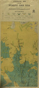
Map, Geological Map of The Stieglitz Gold Field, 1940
At the bottom of the 2nd page, there is text that reads "Geologically and topographically surveyed in 1909 by W.H. Ferguson, Assistant Field Geologist. Published 1940."Rectangular geological map edged in masking tape showing Steiglitz, Victoria. Scale 48 chains to 4 inches.steiglitz, geology, geological map, north albion, moreep, mining, mine, caribald reef, durdidwarrah, gilbraltar hill, mount pleasant gully, township of steiglitz, w.h. ferguson, garibaldi reef, yankee gully, kinglock mine engine shaft, herbert werner frederick de nully, albion gully, virago reef, mulrooney's reef -
Federation University Historical Collection
Report, Cultural Landscapes Study of Creswick Goldfields Area for Australian Hertiage Commission
White bound report with clear covergoldfields of victoria, goldfields tourism, marketing, tourism, creswick, creswick goldfields, allendale, broomfield, rocklyn, bullengarook, mollongghip, dean, scrub hill, clarkes hill, creswick railway station, creswick school of forestry, sawpit gully, oak gully, creswick cemetery, kingston, creswick avenue of honour, kerrins bridge, berry deep leads mine system, australasian mine site, creswick alluvial workings, calembeen park, ascot, anderson's mill, smeaton, hepburn lagoon