Showing 11018 items matching " land"
-
 Ringwood and District Historical Society
Document - Subdivision Map, Part of Crown Portion 22 Parish of Ringwood, County of Mornington. Vol 1915 Fol 827 - LP2427
LANDATA Land Victoria 4-sheet plan dated January 2003 - copy of original 1889 subdivision, amended with 1947 amendments by Assistant Registrar of Titles.Sheet 1 includes Main Lilydale Road (later Old Lilydale Road), Wandin Road (later Mount Dandenong Road), and Joseph Street, Ringwood East. Additional Plan markings SP30844, SP32804, LP144251, PS332061, PS305232. Sheet 2 includes Main Lilydale Road (later Old Lilydale Road), Wandin Road (later Mount Dandenong Road), and Dynes Street, Ringwood East. Additional Plan markings LP43708, LP44231, LP124702. Sheet 3 includes Main Lilydale Road (later Old Lilydale Road), Dynes Street, Albert Street (later Wyrunga Street), and Carcoola Road, Ringwood East. Additional Plan markings LP114181, LP114180, LP18261, LP214030, LP67300, PS354509, PS335500. Sheet 4 includes Main Lilydale Road (later Old Lilydale Road), Albert Street (later Wyrunga Street), and Carcoola Road, Ringwood East. Additional Plan markings PS315494, PS319495. -
 Lakes Entrance Historical Society
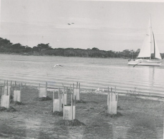
Photograph, Lakes Post Newspaper, Shaving Point Metung Victoria, 1/05/1992 12:00:00 AM
Black and white photograph of newly planted shrubs on shoreline, sailing boat on lake, timbered land opposite, taken from Shaving Point Metung Victoriawaterways, topography -
 Ringwood RSL Sub-Branch
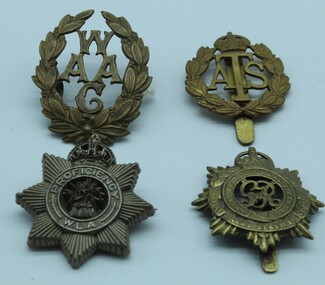
Badge - Badges British
00512. 1. Women's Army Auxiliary Corps .2. Auxiliary Territorial Service .3. Women's Land Army .4. Royal Army Serve Corps -
 Ringwood and District Historical Society
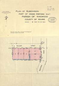
Map - Plan of Subdivision, Part of Crown Portions 6 & 7, Parish of Ringwood, County of Bourke - 1960
Copy of land title map on light cardboard backing showing layout and size of 5 residential allotments in Walmer Street and Wantirna Road, Ringwood, Victoria.Ref. 3725 Date 15-8-1960 Amended 7-9-1960. Little & Brosnan, Licensed Surveyors & Engineers, 422 Little Collins Street, Melbourne. Telephone MU 5111. -
 Ringwood and District Historical Society
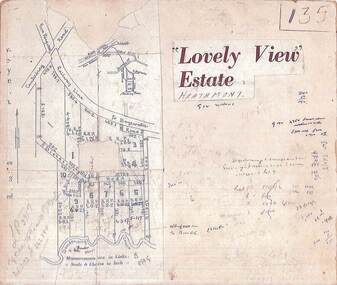
Map, Plan of Subdivision - Lovely View Estate, Heathmont, Victoria (Undated, circa 1930s)
Photocopied map from land sale brochure with handwritten real estate sales notations. Subdivision includes allotments on Dickason's Road and Allen's Road, Heathmont.LP3917 Part of Crown Allotments 14A-40A Parish of Ringwood. Vol 3232 Fol 626380. -
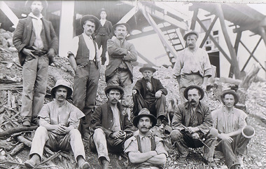 Bendigo Historical Society Inc.
Photograph - The Sedgwick Gold Mine, abt 1909
The Phil Wilkin Collection contains a series of 11 Items. The related items can be found by clicking on the reference link below. The following history of the Young family and their descendants who lived at the Springs is provided by Phil Wilkin. His Great Grandparents were Frances Young and August Wirth. Phil has also provided notes on the Wilkin Family and some history of the gold mining in Sedgwick. Frances Young's parents Joseph and Margaret Young owned the property called "The Old Place, Preston Vale or Wellington Flat" at Sedgwick near the Springs. Joseph Young owned and Managed the Standard Brewery which was located at Campbells Creek during the slate 1800’s early 1900’s. Joseph and Margaret are buried in the Harcourt cemetery. In 1880 August Wirth lived at Mosquito Creek (Lake Eppalock, Victoria) when he married Frances Young. In 1902 they moved to part of Joseph Young's property. They milked cows and sold cattle for a living. One of their children Charles Wirth (Phil Wilkin's Grandfather) bought the land in 1935 after his parents had died. Charles Wirth was a councillor and also was president of the Shire of Strathfieldsaye. The "Old Place" was part of the property owned by members of the family. The old house at the Springs was burnt out by bushfire in January 1944 and much of the stonework was later vandalized by campers. The original Coliban Water Works were designed in 1863 by the Irish engineer Joseph Brady. The system included 70 kilometres of open water channels, aqueducts, syphons and tunnels to carry water (by gravity) from the Coliban River at Malmsbury, north to Castlemaine and Bendigo. Sedgwick is a locality in Central Victoria, Australia. It is located in the City of Greater Bendigo. Facilities include a public hall that opened in 1958 and CFA Rural fire station. It was named Upper Emu Creek until 1901 when it was renamed as Sedgwick after British geologist Adam Sedgwick.Four photos of the miners and information on the Sedgwick Gold Mine. There are 182 photos in this series and can be found at 8683.1 to 8683.11. The series also includes photos of the surrounding farming land and the remains of an old house. There are also some notes on the pioneers of the district.history, bendigo, coliban water, joseph brady, irrigation, the springs, sedgwick, phil wilkin collection, sedgwick gold mine -
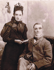 Bendigo Historical Society Inc.
Photograph - Joseph and Margaret Young from Preston Vale (near The Springs) Sedgwick, 1800s-1900s
The Phil Wilkin Collection contains a series of 11 Items. The related items can be found by clicking on the reference link below. The following history of the Young family and their descendants who lived at the Springs is provided by Phil Wilkin. His Great Grandparents were Frances Young and August Wirth. Phil has also provided notes on the Wilkin Family and some history of the gold mining in Sedgwick. Frances Young's parents Joseph and Margaret Young owned the property called "The Old Place, Preston Vale or Wellington Flat" at Sedgwick near the Springs. Joseph Young owned and Managed the Standard Brewery which was located at Campbells Creek during the late 1800’s early 1900’s. Joseph and Margaret are buried in the Harcourt cemetery. In 1880 August Wirth lived at Mosquito Creek (Lake Eppalock, Victoria) when he married Frances Young. In 1902 they moved to part of Joseph Young's property. They milked cows and sold cattle for a living. One of their children Charles Wirth (Phil Wilkin's Grandfather) bought the land in 1935 after his parents had died. Charles Wirth was a councillor and also was president of the Shire of Strathfieldsaye. The "Old Place" was part of the property owned by members of the family. The old house at the Springs was burnt out by bushfire in January 1944 and much of the stonework was later vandalized by campers. The original Coliban Water Works were designed in 1863 by the Irish engineer Joseph Brady. The system included 70 kilometres of open water channels, aqueducts, syphons and tunnels to carry water (by gravity) from the Coliban River at Malmsbury, north to Castlemaine and Bendigo. Sedgwick is a locality in Central Victoria, Australia. It is located in the City of Greater Bendigo. Facilities include a public hall that opened in 1958 and CFA Rural fire station. It was named Upper Emu Creek until 1901 when it was renamed as Sedgwick after British geologist Adam Sedgwick.12 photos and historical document of Joseph and Margaret Young. There are 182 photos in this series and can be found at 8683.1 to 8683.11. The series also includes photos of the surrounding farming land and the remains of an old house. There are also some notes on the pioneers of the district.history, bendigo, coliban water, joseph brady, irrigation, the springs, sedgwick, phil wilkin collection, standard brewery campbells creek, joeseph and margaret young -
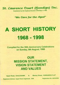 Bendigo Historical Society Inc.
Newsletter - St Laurence Court History, 1968-1998
An initial meeting between the Bendigo Catholic Diocese and the Brotherhood of St Laurence took place in September 1966. Land was acquired in Upper California Gully and the first flats were occupied by August 1968. In 1989 a thirty bed hostel was opened in Wesley Street, Kangaroo Flat and this was extended to 50 beds in 1993. Constant extensions on both sites have allowed for more flats, hostel beds and emergency units.St Laurence Court (Bendigo) Inc. - A Short History B4 Newsletter consisting of 7 pages: Cover: St. Established by the Anglican Diocese of Bendigo, compiled for the 30th Anniversary Celebrations on Sunday, 9th August, 1998. Page 1 First meeting, land purchase and stages of building. Page 2-3 Present Accommodation and Board Members. Page 4 Merchardising, Volunteers and Residents. Page 5 Administration Staff. Page 6 Mission Statement and Values. Page 7 Vision Statement. history, bendigo, merle lummis collection, st laurence court bendigo, aged care, benetas residential aged care -
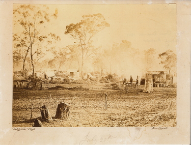 Bendigo Historical Society Inc.
Photograph - SANDHURST, c1867
Sepia photograph: Diggings at Myers Creek July 20, 1867 Victoria, Australia. Tents on left side, partly built hut on right side, three men one sitting two standing. Physical description: copy of original, unmounted. Inscriptions/Markings: from copy by Claver Carroll, Myers Creek Diggings 1867, Vic AustraliaBatchelder Photoplace, land, mining, dolly carroll, c/o 9 brooke st, eaglemont, vic. 3084 -
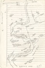 Bendigo Historical Society Inc.
Document - PETER ELLIS COLLECTION: SKETCH OF THE BARFOLD GORGE
Two photocopies of hand-drawn sketch of the Barfold Gorge. On the sketch is the location of a house, trees, fences, different types of rock, some accessible areas to get down to the river, geological features and water falls.place, land, barfold gorge, peter ellis collection, barfold area, mitchell's falls, queen's fall -
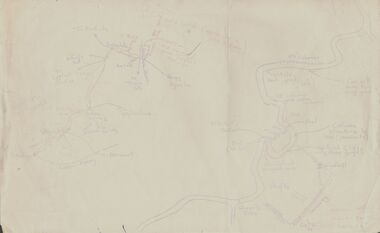 Bendigo Historical Society Inc.
Document - PETER ELLIS COLLECTION: SKETCH OF THE BARFOLD GORGE
Two hand sketched maps on same sheet of paper, one of the location of the Barfold Gorge in relation to surrounding towns, Mt Alexander and Turpin;s Falls. The second map is a part of the Campaspe River location of the Barfold Gorge. Shown is the location of columns, pools, type of rock, Mitchell's Falls, tunnel, cave, Queen's Falls, house, windmill, fences and places where access to the bottom of the gorge is possible. Car track and scale of 1 mile = 6 inches are also shown.place, land, barfold gorge, peter ellis collection, mitchell's falls, queen's falls, turpin's falls -
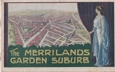 Melbourne Tram Museum
Book, T. M. Burke, "The Merrilands Garden Suburb", late 1919
Book - 12 pages with a fold out double page centre map, centre stapled, titled "The Merrilands Garden Suburb", a real estate marketing brochure for area to the west of the Reservoir rail line, known locally as Merrilands. Marketed on being a gardens suburb to the then Town Planning situation. Contains a suggested loop tram system. Has sales conditions, general information. Marketed by T. M. Burke of 340 Collin St Melbourne. Fold out surveyors map, by Saxil Tuxen, Licensed Surveyor date Oct. 1919. Shows suggested tram routes, reserves, and civic centre.trams, tramways, real estate, reservoir, proposals, new tramway, land -
 Kew Historical Society Inc
Journal - Visitor Book, Fairyland 1963-1965
"Fairyland", the home of Jim and Grace Tabulo, was a major local, state and international tourist attraction situated in Kew, Victoria during the mid twentieth century. Located at 57 Malmsbury Street, Kew, the weatherboard house and its garden were heavily decorated with statues, crockery and other collected items. A series of notebooks were used to record the messages of child and adult visitors to the property from the 1940s to the 1960s. After Mrs Tabulo's death, these visitor books are believed to have formed part of the Dorothy Rogers Collection. They entered the Kew Historical Society's collection following her death in 1973.This series of visitor books are the most important primary sources relating to the internationally renowned 'Fairyland' cottage in Malmsbury Street, Kew. Their social significance is that they record in the post war period the values and beliefs of children and adults who visited this historically significant tourist attraction.Visitor book containing handwritten comments and drawings primarily made by children during visits to the home of Grace Tabulo, in the period 6 January 1963 to 26 December 1965. Commonly known as "Fairyland", the house was located at 57 Malmsbury Street Kew. The book is wrapped in brown paper, which covers a black binding. Unpaginated, 93pp. On front cover: "MRS TABULO: 1879-1966/ "FAIRY HOUSE" / 1963 /- /1965" On title page: "FAIRY LAND Kew / JANUARY 6th 1963"grace tabulo, fairyland - 57 malmsbury street (kew), tourism - kew - 1945-1965, childhood - kew, collectors and collecting, gardens - kew (vic), scrapbooks - 20th century -
Kew Historical Society Inc
Journal - Visitor Book, [1962-1963]
"Fairyland", the home of Jim and Grace Tabulo, was a notable local, state and international tourist attraction situated in Kew, Victoria during the mid twentieth century. Located at 57 Malmsbury Street, Kew, the weatherboard house and its garden were heavily decorated with statues, crockery and other collected items. A series of notebooks were used to record the messages of child and adult visitors to the property from the 1940s to the 1960s. After Mrs Tabulo's death, these visitor books are believed to have formed part of the Dorothy Rogers Collection. They entered the Kew Historical Society's collection following Dorothy Roger's death in 1973.This series of visitor books are the most important primary sources relating to the internationally renowned 'Fairyland' cottage in Malmsbury Street, Kew. Their social significance is that they record in the post war period the values and beliefs of children and adults who visited this historically significant tourist attraction.Foolscap size visitor book containing handwritten comments and drawings primarily made by children during visits to the home of Grace Tabulo, 4 January 1962- 30 January 1963. Commonly known as "Fairyland", the house was located at 57 Malmsbury Street Kew. The book is wrapped in brown paper, which covers back cardboard covers with a red cloth strip binding. Approximately 139 pages, and covers. Note pages are paginated, commencing at page 36.Handwritten in pencil on paper cover: "1962/ 1963" Handwritten in ink on label adhered to front cover: "January 4 / 1962 / Fairy Land/ Kew"grace tabulo -- fairyland -- 57 malmsbury street -- kew (vic.), tourism - kew - 1945-1965, childhood - kew, collectors and collecting, gardens - kew (vic), scrapbooks - 20th century -
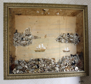 Flagstaff Hill Maritime Museum and Village
Artwork, other - Wall decoration, late 19th century
This unusual wall decoration was created by Anna Wilson (nee Henry), daughter of pioneer John Stephenson Henry, who arrived in Australia from Ireland with his children in 1851. Family documents confirm that Anna most probably made the diorama for her sister-in-law, who married a member of the Giles family. The diorama was later given to Vera Giles who was a family friend and possibly related to Anna’s sister-in-law by marriage. The diorama is now part of the Giles Collection. Anna married William Wilson in 1860, who had arrived in Australia from County Tarrane in about 1850, aged 19. In 1869 they moved to their new property called ‘Glenlyall’ in Cooramook, north of Grassmere, Victoria, where he lived for 49 years until his death in 1918. He left behind a family of four sons and a daughter. The Giles Family There are many 19th century items of furniture, linen and crockery donated to Flagstaff Hill Maritime Village by Vera and Aurelin Giles. The items are associated with the Giles Family and are known as the “Giles Collection”. These items mostly came from the simple home of Vera’s parents-in-law, Henry Giles and his wife Mary Jane (nee Freckleton), whose photos are in the parlour. They married in 1880. Henry Giles was born at Tower Hill in 1858. He was a labourer on the construction of the Breakwater before leaving in 1895 to build bridges in N.S.W. for about seven years. Mary Jane was born in 1860 at Cooramook. She attended Mailor’s Flat State School where she was also a student teacher before, as family legend has it, she became a governess at “Injemiara” where her grandfather, Francis Freckleton, once owned land. Henry and Mary’s family of six, some of whom were born at Mailor’s Flat and later children at Wangoom, lived with their parents at Wangoom and Purnim west, where Henry died in 1933 and Mary Jane in 1940. The family of the creator Anna Wilson nee Henry and her husband William Wilson are of significance to the early history of Victoria and the South West of Victoria in particular, being pioneer families who farmed the land, built the towns and cities and contributed to their communities. The Giles family collection has social significance at a local level, because it illustrates the level of material support the Warrnambool community gave to Flagstaff Hill when the Museum was established. Wall decoration, diorama with decorative gild frame and glass front. The 3-dimensional seascape includes sailing boats, land and sea, all made from materials such as shells, coral and seaweed. The work was made by Anna Wilson. It is part of the Giles Collection.Noneflagstaff hill, warrnambool, shipwrecked-coast, flagstaff-hill, flagstaff-hill-maritime-museum, maritime-museum, shipwreck-coast, flagstaff-hill-maritime-village, giles collection, henry giles, tower hill, cooramook, warrnambool breakwater, mailor’s flat, wangoom, 19th century household goods, 19th century decor, 19th century handcraft, handcraft, wall hanging, diorama of a seascape -
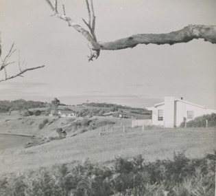 Lakes Entrance Historical Society
Photograph - " Corumbene" Carpenter Street Lakes Entrance, 1/11/1952 12:00:00 AM
White house in foreground Basil and Joan Mitchelson's, white house closer to Corumbene home of Jack and Aileen Daniel. Land adjacent to North Arm later subdivided for residential development Lakes . Corumbene later subdivided fronted by Carpenter Street today. House moved from Coates Rd to O'Neils Rd Lakes Entrance 1989 Black and white photograph of the property Corumbene at back of photograph behind tall tree c1952. White house in foreground Basil and Joan Mitchelson's, white house closer to Corumbene home of Jack and Aileen Daniel. Land adjacent to North Arm later subdivided for residential development Lakes Entrance Victoria. Also another black and white photographs showing property Corumbene later subdivided fronted by Carpenter Street today. Plus 2 coloured photos of a house being moved from Coates Rd to O'Neils Rd Lakes Entrance 1989land development, houses -
 Bendigo Historical Society Inc.
Document - H.A. & S.R. WILKINSON COLLECTION: CONTRACT OF SALE
Contract of sale of land dated 8th May, 1964 between Mr. Harold Nankivell (Executor John Nankivell deceased) vendor and Mr. A. K. Steel (purchaser). Vendor solicitor: Watson, James & Rogers, Bull Street, Bendigo. Solicitor for purchaser: Watson, James & Rogers, Bull Street, Bendigo. Property: Cathcart Street, Marong land being part of Crown allotment A6 Parish of Marong, land comprised in certificates of title volume 3186 olio 198 and volume 5025 folio 996, including floor coverings, blinds, curtains and electric light fittings and hall runner. Price 800 pounds.organization, business, h.a. & s.r wilkinson real estate -
 Bendigo Historical Society Inc.
Document - H. A. & S. R. WILKINSON COLLECTION: CONTRACT OF SALE
Contract of sale of land dated 17th March, 1952 between Mr. L. Batchelder (vendor) and Mr. E. Simmons (purchaser). Property: land being part of Crown allotment 14 and 15 section 4B, Parish of Sandhurst City of Bendigo, land described in deed of conveyance memorial No. 589 book No. 560 and situate no. 64 Short Street, Bendigo, together with 7 roomed weatherboard dwelling and all sundry outbuildings, all window blinds, curtains, electric light fittings and shades, blinds and all floor coverings except those on front bedroom and dining room. Price: 4,650 pounds.organization, business, h.a. & s.r wilkinson real estate -
 Bendigo Historical Society Inc.
Document - H. A. & S. R. WILKINSON COLLECTION: CONTRACT OF SALE
Contract of sale of land dated 19th June, 1956 between Mrs. L. A. E. Ham & Sandhurst and Northern District Trustees Executors and Agency Company (vendor) and Mr. R. G. & Mrs. T. Perl. Solicitor for vendor: Hyett, Willis & Hyett, Bendigo. Solicitor for purchaser: Hyett, Willis & Hyett, Bendigo. Property: piece of land being Crown allotment3 and part of Crown allotment 1 section 130C land described in certificate of title volume 3525 folio 865, together with all improvements thereon including all blinds. Price: 4,600 pounds. Attached 3 hand written notes.organization, business, h.a. & s.r wilkinson real estate -
 Bendigo Historical Society Inc.
Document - H. A. & S. R. WILKINSON COLLECTION: CONTRACT OF SALE
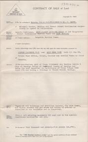
Contract of sale of land dated 23rd May, 1956 between Mrs. M. A. L. Tobin - Mrs N. McMahon as executors of estate G. C. La Franz - deceased (sellers) and Mr. A. C. & Mrs. M. E. Tait (purchaser). Property: land being part of Crown allotment 6 section 12B Parish of Sandhurst City of Bendigo, land described in certificate of title volume 2592 folio 274 and having a frontage to Violet Street, Bendigo, together with all buildings thereon, fly wire doors, window screens and gas stove and blinds. Price: 4,075 pounds. Office copyorganization, business, h.a. & s.r wilkinson real estate -
 Bendigo Historical Society Inc.
Document - H. A. & S. R. WILKINSON COLLECTION: CONTRACT OF SALE
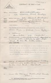
Contract of sale of land dated 19th December, 1955 between Mr J. S. Henderson as executor of estate of W. J. Henderson (vendor) and Mrs E. & Mr. F. J. Taylor (purchaser). Property: all that piece of land being part of Crown allotment 10 and 11 section 9A Parish of Sandhurst city of Bendigo being land described in certificate of title volume 5221 folio 175 and situate No. 641 High Street corner fir Street, Golden Square, together with 5 roomed weatherboard dwelling , all sundry outbuildings and all blinds. Price: 2,200 pounds.organization, business, h.a. & s.r wilkinson real estate -
 Bendigo Historical Society Inc.
Document - H. A. & S. R. WILKINSON COLLECTION: CONTRACT OF SALE
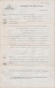
Contract of sale of land dated 7th January 1952 between Mr. H. & Mrs. E. M. Muir (vendor) and Mrs. R. F. Turvey (purchaser). Property: land being allotment 118B section D in the Township of Kangaroo Flat Parish of Sandhurst County of Bendigo, containing 1 rood 38 perches and 1/10 of a perch land described in Crown grant volume 7454 folio 004 and situate in Railway Terrace, Kangaroo Flat, together with 5 roomed weatherboard dwelling and all sundry outbuildings, also all blinds and electric light fittings and shades. Price 875 pounds.organization, business, h.a. & s.r wilkinson real estate -
 Bacchus Marsh & District Historical Society
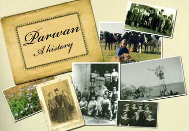
Book, Parwan: A History, 2010
Explores the history of the small farming community on the outskirts of Bacchus Marsh. It contains a plethora of fascinating details about the early years of this farming community from the 1830s until the early 2000s. There is a brief section at the beginning which looks at the history of the area prior to the colonial era. The book contains numerous sections about families and individual people who have lived in the Parwan area and includes many images of places and people. Citation: Parwan: A History by Dianne Van Leuvan. Published by Parwan History Group, Bacchus Marsh, Vic., 2010.Paperback printed book. 128 pages. with illustrations and photographs, some coloured. Includes facsimiles, maps, and index. Includes a separate folded sheet inside a pocket which has a reproduction of a map of the Parwan Parish in the County of Grant. On the reverse of this sheet are two reproductions. One is a land auction plan for February 1910 advertising the sale of portions of land from the Nerowie Estate. The other reproduction is a section of a map showing some of the blocks of land in the Nerowie Estate which has the heading, 'Nerowie Titles 1898'. A pocket inside the back cover contains a separate booklet which is an index, and two pages of 'Additional Information'.non-fictionExplores the history of the small farming community on the outskirts of Bacchus Marsh. It contains a plethora of fascinating details about the early years of this farming community from the 1830s until the early 2000s. There is a brief section at the beginning which looks at the history of the area prior to the colonial era. The book contains numerous sections about families and individual people who have lived in the Parwan area and includes many images of places and people. Citation: Parwan: A History by Dianne Van Leuvan. Published by Parwan History Group, Bacchus Marsh, Vic., 2010.parwan vic. history -
 Bendigo Historical Society Inc.
Document - H.A. & S.R. WILKINSON COLLECTION: CONTRACT OF SALE
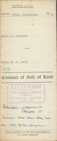
This business was owned by father and son, Henry Archibald Wilkinson and Samuel Ronald "Ron" Wilkinson. Henry (1882-1954) was born in Shepparton and died in Bendigo. He was married to Grace Hovendon in 1908. Samuel Ronald "Ron" (1914-1995), Henry's son, was married to Florence Jean McKerlie in 1937.Contract of sale of land dated 26th September, 1955 between Mrs. I. Forster (seller) and Mrs. E.V. Raff (buyer) for land being lot 2 on plan of subdivision No.3905 lodged at the office of titles being part of Crown allotment 8 section 8 portion B described in certificate of title volume 4045 folio 961 situate No. 142 Myrtle Street, Bendigo. Together with right of carriage way over land at rear of property with weatherboard dwelling and all sundry, also all floor coverings, blinds, curtains, electric light fittings and shades and 'Pope' washing machine. Price 3,200 pounds.organization, business, h.a. & s.r wilkinson real estate -
 Bendigo Historical Society Inc.
Document - H.A. & S.R. WILKINSON COLLECTION: CONTRACT OF SALE
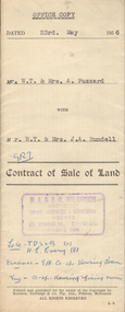
This business was owned by father and son, Henry Archibald Wilkinson and Samuel Ronald "Ron" Wilkinson. Henry (1882-1954) was born in Shepparton and died in Bendigo. He was married to Grace Hovendon in 1908. Samuel Ronald "Ron" (1914-1995), Henry's son, was married to Florence Jean McKerlie in 1937.Contract of sale of land dated 23rd May, 1956 between Mr. W.T. & Mrs. A. Fuzzard (sellers) and Mr. W.T. & Mrs. J.A. Rundell for land being part of allotment 5 section A, Sailors Gully, having a frontage of 66 feet to Sailors Gully Road, Eaglehawk by a depth of 82 feet 6 inches being land described in deed of conveyance book 463 memorial No.742 and situate No. 64 Sailors Gully Road, Eaglehawk, together with 5-roomed weatherboard dwelling. Also all linos, blinds, electric light fittings and shades and electric copper. Price 2,650 pounds.organization, business, h.a. & s.r wilkinson real estate -
 Bendigo Historical Society Inc.
Document - H.A. & S.R. WILKINSON COLLECTION: CONTRACT OF SALE
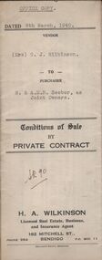
Conditions of sale by private contract dated 8th March, 1940 between Mrs. G.J. Wilkinson (seller) and R. and A.M.B. Seeber (buyers) for land situate Panton Street, Golden Square, being Crown allotment 1 section 6A land described in certificate of title volume 3571 folio 750198, together with 5-roomed weatherboard dwelling and all sundry. Price 350 pounds.organization, business, h.a. & s.r wilkinson real estate -
 Bendigo Historical Society Inc.
Document - H.A. & S.R. WILKINSON COLLECTION: CONTRACT OF SALE
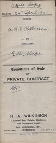
Conditions of sale by private contract dated 24th April, 1941 between A.B.P. Pattison (seller) and G.H. Sharpe (buyer) for land situate No. 19 Hayes Street, Bendigo, being land described in right to occupy residence area No. 7157, together with 6-roomed weatherboard and brick dwelling and all sundry. Price 190 pounds. Attached receipt signed by Mr. Pattison acknowledging payment.organization, business, h.a. & s.r wilkinson real estate -
 Bendigo Historical Society Inc.
Document - H.A. & S.R. WILKINSON COLLECTION: CONTRACT OF SALE
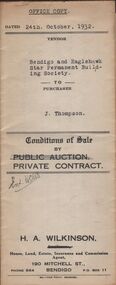
Conditions of sale by private contract dated 24th October, 1932 between Bendigo and Eaglehawk Star Permanent Building Society (seller) and J. Thompson (buyer) for land situate Lily Street, Bendigo being Crown allotment 1B section 14B described in Crown grant volume 258 folio 51486, together with all dwellings and erections on the said land. Price 315 pounds.organization, business, h.a. & s.r wilkinson real estate -
 Bendigo Historical Society Inc.
Document - H.A. & S.R. WILKINSON COLLECTION: CONDITION OF SALE
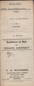
Conditions of sale by private contract dated 20th January, 1941 between Mrs J. E. Neivandt (seller) and G. Tussup (buyer) for land situated No. 52 Nolan Street, Bendigo, at present occupied by Mrs. Nolen, as tenant, and being land described in right to occupy residence area No. 022, together with 5-roomed weatherboard dwelling and all sundry. Price 310 poundsorganization, business, h.a. & s.r wilkinson real estate -
 Bendigo Historical Society Inc.
Document - H.A. & S.R. WILKINSON COLLECTION: CONTRACT OF SALE
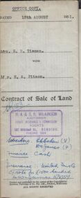
Contract of sale of land dated 15th August, 1951 between Mrs. E.R. Tieman (seller) and Mr. H.A. Pitson (buyer) for land being part of Crown allotment 6 section 71C described in certificate of title volume 4173 folio 834590 situate No. 47 Station Street, Bendigo, together with 4-roomed weatherboard dwelling and all sundry. Price 1,720 pounds.organization, business, h.a. & s.r wilkinson real estate