Showing 4870 items
matching 1930s-1940s
-
 Kew Historical Society Inc
Plan - Subdivision Plan, J R Mathers & McMillan, Myrtle Hill Estate, East Kew, circa 1949, c.1949
The Kew Historical Society's map collection includes a substantial number of real estate subdivision plans, mainly of Kew but also of surrounding suburbs in Melbourne. Most of the subdivision plans date from the 1920s and 1930s when the districts old homes and local farmland were being split up to accommodate residential growth in the postwar period. These early plans were assembled by a local firm, Jas R Mather & McMillan, which had an office in Cotham Road. Many of the plans, and sometimes photos, were annotated by the agents.Subdivision plans are historically important documents used as evidence for the growth of suburbs in Australia. They frequently provide information about when the land was sold as well as evidence relating to surveyors and real estate and financial agents. The numerous subdivision plans in the Kew Historical Society's collection represent working documents, ranging from the initial sketches made in planning a subdivision to printed plans on which auctioneers or agents listed the prices for which individual lots were sold. In a number of cases, the reverse of a subdivision plan in the collection includes a photograph of a house that was also for sale by the agent. These photographs provide significant heritage information relating house design and decoration, fencing and household gardens.The photograph may also be aesthetically significant depending on the importance of the photographic atelier.Myrtle Hill, at 14 Vista Avenue, Kew, is of local historical and architectural significance as a good example of a large and imposing single-storey Italianate house of the early 1870s surviving in Kew. Originally sited on a large allotment overlooking Normanby Road, the setting of the house has been dramatically altered through extensive subdivision and development. The subdivision plan of the ‘Myrtle Hill Estate’ indicates that in one such subdivision, 11 allotments were created fronting Bowyer Avenue, Myrtle Avenue, and Normanby Road. The outline and building profile of Myrtle Hill is shown on the west side of Bowyer Avenue.The full (typed) title of this subdivision plan is :"Plan of SUBDIVISION of part of CROWN PORTION 83. / at KEW / PARISH OF BOROONDARA. / COUNTY OF BOURKE". / "MYRTLE HILL ESTATE / EAST KEW" In addition to the Title and subtitle, the plan also lists the advantages of the subdivision. -
 Kew Historical Society Inc
Plan - Subdivision Plan, J R Mathers & McMillan, Normanby Estate, c.1913
The Kew Historical Society's map collection includes a substantial number of real estate subdivision plans, mainly of Kew but also of surrounding suburbs in Melbourne. Most of the subdivision plans date from the 1920s and 1930s when the districts old homes and local farmland were being split up to accommodate residential growth in the postwar period. These early plans were assembled by a local firm, Jas R Mather & McMillan, which had an office in Cotham Road. Many of the plans, and sometimes photos, were annotated by the agents.Subdivision plans are historically important documents used as evidence for the growth of suburbs in Australia. They frequently provide information about when the land was sold as well as evidence relating to surveyors and real estate and financial agents. The numerous subdivision plans in the Kew Historical Society's collection represent working documents, ranging from the initial sketches made in planning a subdivision to printed plans on which auctioneers or agents listed the prices for which individual lots were sold. In a number of cases, the reverse of a subdivision plan in the collection includes a photograph of a house that was also for sale by the agent. These photographs provide significant heritage information relating house design and decoration, fencing and household gardens.The photograph may also be aesthetically significant depending on the importance of the photographic atelier.The Normanby Estate, which was adjacent to Normanby Road, Kew East, included thirty-one lots for sale. Streets on the subdivision plan include Adeney Avenue, Park Hill Road, Normanby Road, Weir Street and Wharton Street. Cotham Road and its tramway are shown nearby. The plan is interesting as it shows Wharton Street, named after the architect and town planner George Wharton, who was the first chairman of the Municipality of Kew. The street was to later be renamed Cecil Street. Also shown are proposed ‘Municipal Gardens’ where Parkhill Drive is now located."D" in top left corner. Stamped auctioneers contact details: "Jas. R. Mathers & Son & McMillan / Auctioneer & Land Salesmen, / 271 Collins Street / Melbourne" and Jas. R. Mathers / Estate & Financial Agent / Cotham Road / Kew".weir street - kew, wharton street - kew, normanby road - kew, cotham road - kew, municipal gardens - kew, park hill parkhill road - kew, braemar - kew, subdivision plans - kew -
 Kew Historical Society Inc
Plan, J R Mathers & McMillan, Sackville, Thomas & Lytton Streets, Kew, Twentieth Century
The Kew Historical Society's map collection includes a substantial number of real estate subdivision plans, mainly of Kew but also of surrounding suburbs in Melbourne. Most of the subdivision plans date from the 1920s and 1930s when the districts old homes and local farmland were being split up to accommodate residential growth in the postwar period. These early plans were assembled by a local firm, Jas R Mather & McMillan, which had an office in Cotham Road. Many of the plans, and sometimes photos, were annotated by the agents.Subdivision plans are historically important documents used as evidence for the growth of suburbs in Australia. They frequently provide information about when the land was sold as well as evidence relating to surveyors and real estate and financial agents. The numerous subdivision plans in the Kew Historical Society's collection represent working documents, ranging from the initial sketches made in planning a subdivision to printed plans on which auctioneers or agents listed the prices for which individual lots were sold. In a number of cases, the reverse of a subdivision plan in the collection includes a photograph of a house that was also for sale by the agent. These photographs provide significant heritage information relating house design and decoration, fencing and household gardens.The photograph may also be aesthetically significant depending on the importance of the photographic atelier.Lithographed subdivision plan for an un-named estate with 28 allotments facing Lytton, Sackville and Thomas Streets in Kew. The land would have originally formed part of the Dumaresq Estate. subdivision plans - kew, lytton street, sackville street, thomas street - kew -
 Kew Historical Society Inc
Plan - Subdivision Plan, Jas R Mathers Son & McMillan, Eastlawn Estate : East Kew Auction Sale, 1914
The Kew Historical Society's map collection includes a substantial number of real estate subdivision plans, mainly of Kew but also of surrounding suburbs in Melbourne. Most of the subdivision plans date from the 1920s and 1930s when the districts old homes and local farmland were being split up to accommodate residential growth in the postwar period. These early plans were assembled by a local firm, Jas R Mather & McMillan, which had an office in Cotham Road. Many of the plans, and sometimes photos, were annotated by the agents.Subdivision plans are historically important documents used as evidence for the growth of suburbs in Australia. They frequently provide information about when the land was sold as well as evidence relating to surveyors and real estate and financial agents. The numerous subdivision plans in the Kew Historical Society's collection represent working documents, ranging from the initial sketches made in planning a subdivision to printed plans on which auctioneers or agents listed the prices for which individual lots were sold. In a number of cases, the reverse of a subdivision plan in the collection includes a photograph of a house that was also for sale by the agent. These photographs provide significant heritage information relating house design and decoration, fencing and household gardens.The photograph may also be aesthetically significant depending on the importance of the photographic atelier.The ‘Eastlawn Estate’ was surveyed and ready for auction in March 1914, three months before the outbreak of World War I. Sixty-six allotments, created on the ‘order of Mr & Miss Preston’ surrounded the mansion of Woodlands in Harp Road. Woodlands formed part of the Estate, being advertised as lot 1. The allotments faced High, Station and Wright Streets, Harp and Normanby Roads, and Woodlands Avenue. Pru Sanderson in the Kew Conservation Study (Vol.2, 1988) wrote that the Eastlawn Estate ‘covered the western half of the failed Harp of Erin Estate’. Contemporary advertisements promoted the Eastlawn Estate as: ‘There will be no more convenient district nor pleasant Suburb than East Kew for the busy business man. When the Electric Tram is laid, he will be able to journey quickly and pleasantly direct from Collins Street to his home in the Eastlawn Estate in about 20 minutes’. The actual plans of subdivision were included in advertisements in The Argus and in the local newspapers."C" top left. Various annotations.subdivision plans - kew, station street, normanby road, high street, woodlands avenue, harp road, woodlands - kew -
 Kew Historical Society Inc
Plan - Subdivision Plan, Winton Estate, East Kew : Sale of 10 Building Blocks, 1920
The Kew Historical Society's map collection includes a substantial number of real estate subdivision plans, mainly of Kew but also of surrounding suburbs in Melbourne. Most of the subdivision plans date from the 1920s and 1930s when the districts old homes and local farmland were being split up to accommodate residential growth in the postwar period. These early plans were assembled by a local firm, Jas R Mather & McMillan, which had an office in Cotham Road. Many of the plans, and sometimes photos, were annotated by the agents.Subdivision plans are historically important documents used as evidence for the growth of suburbs in Australia. They frequently provide information about when the land was sold as well as evidence relating to surveyors and real estate and financial agents. The numerous subdivision plans in the Kew Historical Society's collection represent working documents, ranging from the initial sketches made in planning a subdivision to printed plans on which auctioneers or agents listed the prices for which individual lots were sold. In a number of cases, the reverse of a subdivision plan in the collection includes a photograph of a house that was also for sale by the agent. These photographs provide significant heritage information relating house design and decoration, fencing and household gardens.The photograph may also be aesthetically significant depending on the importance of the photographic atelier.Subdivision plan for the so-called Winton Estate in East Kew. The Estate comprised 10 lots facing Simpson Street and Campbell Street. The estate was auctioned by Jas. R. Mathers, Son and McMillan. campbell street, simpson street, hunter street, normanby road - kew, subdivision plans - east kew, subdivision plans - kew -
![7 Roomed Brick [villa]; Modern Conveniences](/media/collectors/550653872162f11fb04854aa/items/59ec3da221ea690fdc4ba793/item-media/59ec3ee521ea690fdc4d0c37/item-fit-380x285.jpg) Kew Historical Society Inc
Kew Historical Society IncPhotograph - 7 Roomed Brick [villa]; Modern Conveniences, 1920s
The Kew Historical Society's map collection includes a substantial number of real estate subdivision plans, mainly of Kew but also of surrounding suburbs in Melbourne. Most of the subdivision plans date from the 1920s and 1930s when the districts old homes and local farmland were being split up to accommodate residential growth in the postwar period. These early plans were assembled by a local firm, Jas R Mather & McMillan, which had an office in Cotham Road. Many of the plans, and sometimes photos, were annotated by the agents.Subdivision plans are historically important documents used as evidence for the growth of suburbs in Australia. They frequently provide information about when the land was sold as well as evidence relating to surveyors and real estate and financial agents. The numerous subdivision plans in the Kew Historical Society's collection represent working documents, ranging from the initial sketches made in planning a subdivision to printed plans on which auctioneers or agents listed the prices for which individual lots were sold. In a number of cases, the reverse of a subdivision plan in the collection includes a photograph of a house that was also for sale by the agent. These photographs provide significant heritage information relating house design and decoration, fencing and household gardens.The photograph may also be aesthetically significant depending on the importance of the photographic atelier.A professionally produced photograph for a local real estate agent, probably Jas. R. Mathers, Son & McMillan. The photograph is of a Federation-era bungalow, in Kew. The photo is on the reverse of a subdivision plan for the Normanby Heights Estate, Kew.The mount on which the photograph is placed includes: "Kew. 1 minute to tram. Good Position. / 7 roomed brick. Modern conveniences. / Land 60 x 135. 1100 pounds"real estate photographs, houses - kew, federation architecture -
 Kew Historical Society Inc
Plan - Subdivision Plan, Argyle Road, Heather Grove, Victor Avenue, Kew, c.1937
The Kew Historical Society's map collection includes a substantial number of real estate subdivision plans, mainly of Kew but also of surrounding suburbs in Melbourne. Most of the subdivision plans date from the 1920s and 1930s when the districts old homes and local farmland were being split up to accommodate residential growth in the postwar period. These early plans were assembled by a local firm, Jas R Mather & McMillan, which had an office in Cotham Road. Many of the plans, and sometimes photos, were annotated by the agents.Subdivision plans are historically important documents used as evidence for the growth of suburbs in Australia. They frequently provide information about when the land was sold as well as evidence relating to surveyors and real estate and financial agents. The numerous subdivision plans in the Kew Historical Society's collection represent working documents, ranging from the initial sketches made in planning a subdivision to printed plans on which auctioneers or agents listed the prices for which individual lots were sold. In a number of cases, the reverse of a subdivision plan in the collection includes a photograph of a house that was also for sale by the agent. These photographs provide significant heritage information relating house design and decoration, fencing and household gardens.The photograph may also be aesthetically significant depending on the importance of the photographic atelier.Undated blue subdivision plan in Kew of 14 lots facing Argyle Road, Heather Grove and Victor Road. The Plan identifies Tuxen & Miller as the surveyors. [Formerly catalogued as MAP.0059]subdivision plans - kew, argyle road - kew, heather grove - kew, victor avenue - kew -
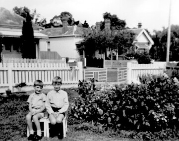 Surrey Hills Historical Society Collection
Photograph, Ray & David Theodoridis of Russell Street, 1960s
The boys have been identified as *Rea & David Theodoridis. they being 2 of 5 children of Peter and Ruth (nee Dawson) Theodoridis. Background shows Nos 11, 13 and 15 Russell Street in the 1960's. In the 1920s-1930s these were the homes of the Scott, Daniels & Hendy families. No 11 was the home of the Scott family (dem); no 13 may also have belonged to the Scott family. No 18 Russell Street, the family home of Eleanor (Lena) & Rea Dawson. * spelling authenticated by Theodata Williams Dec 2019A black and white photograph of two young boys sitting on small chairs in a front garden. There are two houses in the background on the other side of the road.russell street, surrey hills, scott family, daniels family, hendy family, (mr) david theodoridis, (mr) george david theodoridis, (mr) rae theodoridis -
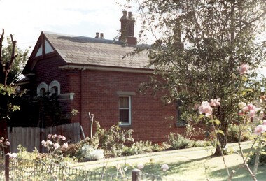 Surrey Hills Historical Society Collection
Photograph, Tavistock at 192 Union Road, 1978
The date is approximate. Tavistock was built c1890. The side windows on the front room are a later addition in a different style from the original windows. In 1897 it was the home of the Walker family; Joyce Walker later became matron of Mosgiel Hospital. In 1902 it became the first site of Milverton Girls School. From 1930s to 1960s it was home to Miss Marjorie Vahland, a locally well-known nursing sister. See History Walks No 5, p 11 and p32 Surrey Hills In Celebration of its Centennial 1883-1983Colour photo of the north side of Tavistock at 192 Union Road, Surrey Hills revealed when this side of the property was partially without a fence; taken while re-fencing. The house is Victorian in style, of red brick construction with a patterned slate tile roof and decorative chimneys.tavistock, milverton girls school, victorian style, houses, joyce walker, miss marjorie vahland, nurses -
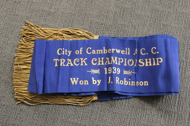 Camberwell Historical Society
Ceremonial object - Sash, City of Camberwell A.C.C. Track Championship cycling sash, 1939
Champion's sash from 1939 awarded to competitive cyclist Jack Stanley Robinson. Jack Stanley Robsinson lived in Canterbury for most of his youth and was a member of the City of Camberwell Amateur Cycling Club in the late 1930s. Jack appears in the press (NLA Trove) as a member of the Malvern cycling team in a March 1934 trial competition of “boys”, and then with increasing frequency in amateur competitions throughout 1935 to 1938. In October 1938 he appears in the Camberwell team. The last entry so far found is in December 1939, still with the Camberwell team. Blue sash with gold tassels 'City of Camberwell A.C.C. Track Championship 1939 Won by J. Robinson'cycling, sport -
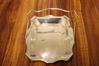 Camberwell Historical Society
Ceremonial object - Trophy tray, City of Camberwell Amateur Cycling Club silver plated tray trophy, 1939
Silver tray trophy awarded to competitive cyclist Jack Stanley Robinson in 1939. Jack Stanley Robsinson lived in Canterbury for most of his youth and was a member of the City of Camberwell Amateur Cycling Club in the late 1930s. Jack appears in the press (NLA Trove) as a member of the Malvern cycling team in a March 1934 trial competition of “boys”, and then with increasing frequency in amateur competitions throughout 1935 to 1938. In October 1938 he appears in the Camberwell team. The last entry so far found is in December 1939, still with the Camberwell team. Silver plated tray with handleInscription which reads 'CCACC 1939 Road Season'cycling, sport, trophy -
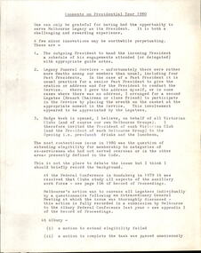 Melbourne Legacy
Document, Comments on Presidential Year 1980 - EK Robertson, 1981
The President in 1980 was Karl Robertson. A major issue for his year in office was the question of the extension of eligibility for membership to categories of ex-servicemen who had not served overseas or in the other areas presently defined in the Code. Document is dated 12/10/1981 as the presidential year ran from March to the following February and this was written sometime after he was replaced as president. Was in a binder of documents that is passed from an outgoing President to the incoming President. It is primarily from the 1930s to 1990s. Most documents are being catalogued separately.A record of the ideas of the President in the 1970s.White foolscap paper x 2 pages with black type of the President's comments in 1980.presidents, karl robertson -
 Melbourne Legacy
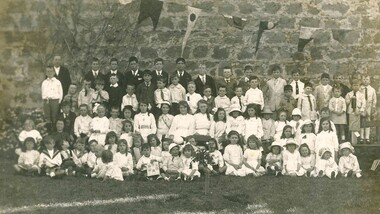
Photograph, From RSSILA Geelong - Christmas 1919, 1918
A group of children in Geelong who's fathers had served during the first World War. The RSSILA (precursor to the RSL) had held an event for them and took this photo which was then distributed to the families at Christmas 1919. Margaret Burn is possibly one in the front row and her family donated the photo. Margaret later attended girls classes with Geelong Legacy in the 1930s and Legacy helped her find employment when she left school. Her family donated two photos and a Laurel Badge to Legacy.A very early photo shows that Geelong RSSILA were looking after the children of soldiers.Sepia photo in a brown cardboard frame of many children taken at a RSSILA Geelong event in 1919.geelong legacy, margaret burn -
 Bendigo Historical Society Inc.
Document - BUSH COLLECTION: EPHEMERA
Ephemera from Original Box 313; This is not a catalogued description of the contents but a broad-brush overall description. a. Book with 'Ledger' on cover; has newspaper cuttings re stage and screen on 8 of 94 pages (remaining, mostly blank); b. Gordon & Gotch - Sample Calendar No. 3 1935.( 61 cm x 50 cm) x2; c. Gordon & Gotch - Sample Calendar No. 2 (61 cm x 50 cm) x 2; d. Victorian Act of Parliament No 3041 (amending the Law relating to Public Health, 1919, 176 pages; e. Victorian Act of Parliament -(amending the Sewerage District Acts No 3437, 1925, 5 pages ; f. Scrapbook with cuttings from papers relating to Australia's history, scenery, flora and fauna, Farming, Industry, Rodeo, Horse Racing, Rural, Surf Life Saving, Religion, Federation, Explorers, Gold, Birds, - some loose cuttings in back; g. Land Tax Act, Schedule L 1910 (blank sheet); h. Commission of Public Health - three day tour of Western District (Warrnambool, port Fairy, Colac) from Melbourne; i. Collection of cuttings, envelopes; j. Newspapers - Argus, Advertiser pages late 1930s; (not scanned) k. Collection of newspaper cuttings; l. Collection of Public Health Regulations, 7 parts; m. Act of Parliament, Victoria No. 2632 - Law relating to Amendment of the Constitution; n. Folder containing issues of The Bendigo Church News, 25 parts 1930s-1950s; o. Collection of book lists/catalogues; p. AA (Automobile Association) Members Handbook 1963; q. Collection of varied sheets and pamphlets; r. Articles of Association - Ocean Salt Company; s.. Sydney Symphony Orchestra program 1953; t. Queen Mary's Message to the people, Jan 1936; u. various notices for display of historical items (BHS Collection)ephemera, mementoes -
 The Beechworth Burke Museum
Photograph, c1960
The photograph depicts a view across the water at Lake Sambell. The image is thought to date from the 1960s so may show the lake during a period of drought, such as that experienced across South-Eastern Australia in 1967. The present day park and reserve occupies the site of the former Rocky Mountain Mining Company, an open-cut sluice mine that began operations in the mid-Nineteenth Century and operated until the early 1900s, through the peak of Victoria’s Gold Rush. It was converted into a park and leisure area in the 1920s. Lake Sambell was formally opened to the public on Friday 5th October 1928 and was opened by the Victorian Government’s Minister of Lands, Mr Bailey, as part of initiatives to boost the economies and development of country towns. The lake was named after Mr L.H. Sambell, a shire engineer and secretary of the Forward Beechworth Committee who was involved in promoting the transformation of the mining site and promoting plantation forestry and tourism as alternative industries. £300 to begin the process was provided by Mr J. McConvill, a former resident of Beechworth, who is remembered in a street name adjacent to the lake. Residents of Beechworth have worked to raise funds to improve the Lake Sambell reserve several times, such as efforts in the 1930s and 1940s to raise the banks several feet to deepen the water for swimming purposes. Fundraising campaigns include the ‘Ugly Man’ competition conducted on behalf of the Wallace Park-Lake Sambell Development Scheme. The latter competition was run by the Fire Brigade Bend’s team as part of a larger competition called the ‘Mile of Pennies’; it was won by Mr Len Knight of Beechworth’s Commercial Hotel. The ‘Mile of Pennies’ was conducted at a Carnival held on New Year’s Eve, 1947. It was proposed by the Beechworth and District Progress Association. As well as improving swimming facilities, funds were raised to install a caravan park facility near the lake. Funds were also donated by commercial entities, such as £250 received from Zwar Bros. Pty Ltd.The photograph is significant as it shows Lake Sambell at lower water levels, such as may have been experienced during period of drought.Sepia rectangular photograph printed on matte photographic paperObverse: nil Reverse: 3470beechworth, beechworth lake, lake sambell, lake, beechworth and district progress association, forward beechworth committee, ugly man, mile of pennies, wallace park lake sambell development scheme, wallace park-lake sambell development scheme, zwar bros, zwar, l.h. sambell, j. mcconvill, minister of lands, commercial hotel, len knight, rocky mountain mining company, rocky mountain mining co, gold rush, redevelopment, transformation, community fundraising, drought, 1967, 1960s -
 Eltham District Historical Society Inc
Photograph - Digital Photograph, Marguerite Marshall, Jelbart home, 93 Arthur Street, Eltham, 11 November 2006
Situated at the top of the hill in Arthur Street, the former Jelbart residence and barn were part of a major change that transformed Eltham's character in the late 1960s. Built from the mid 1940s through mid 1950s when Eltham was a rural community, the Jelbrat residence and barn are all that remain of a family property of some 250 acres (100 ha). With growing population pressures, in the late 1960s, owners Ron and Yvonne Jelbart decided to subdivide their property creating the Woodridge Estate in the early 1970s, a major factor towards the transformation of Eltham to the suburb it is today. The Jelbarts had moved to Eltham in the early 1940s when they purchased a poultry farm in New Street, now Lavendar Park Road. (The local Black Friday bushire of January 13, 1939 had started at C.A. (Clarrie) Hurst’s Eltham Poultry Farm and Hatchery in New Street.) Jelbart was primarily a businessman importing office machinery but desired farm beef and dairy cattle so the couple purchased the virgin bushland at what was then at the end of a dirt road, Arthur Street. With post war shortages of most building materials, they followed the example of the Eltham Artists' Colony (later called Montsalvat) and built thier home from mud-bricks and recyclked materials. The barn was first to be completed in 1945 which they made their home whilst building the main residence. It took eight years to complete the two buildings. Both the main residence and the barn are now separate homes, and along with the remaining property being sub-divided further in 1998 are now part of the Kinloch Gardens Estate at 93 Arthur Street. Covered under Heritage Overlay, Nillumbik Planning Scheme. Published: Nillumbik Now and Then / Marguerite Marshall 2008; photographs Alan King with Marguerite Marshall.; p139This collection of almost 130 photos about places and people within the Shire of Nillumbik, an urban and rural municipality in Melbourne's north, contributes to an understanding of the history of the Shire. Published in 2008 immediately prior to the Black Saturday bushfires of February 7, 2009, it documents sites that were impacted, and in some cases destroyed by the fires. It includes photographs taken especially for the publication, creating a unique time capsule representing the Shire in the early 21st century. It remains the most recent comprehenesive publication devoted to the Shire's history connecting local residents to the past. nillumbik now and then (marshall-king) collection, eltham, arthur street, jelbart barn, jelbart home, kinloch gardens -
 Eltham District Historical Society Inc
Photograph - Digital Photograph, Marguerite Marshall, Jelbart Barn, 93 Arthur Street, Eltham, 11 November 2006
Situated at the top of the hill in Arthur Street, the former Jelbart residence and barn were part of a major change that transformed Eltham's character in the late 1960s. Built from the mid 1940s through mid 1950s when Eltham was a rural community, the Jelbrat residence and barn are all that remain of a family property of some 250 acres (100 ha). With growing population pressures, in the late 1960s, owners Ron and Yvonne Jelbart decided to subdivide their property creating the Woodridge Estate in the early 1970s, a major factor towards the transformation of Eltham to the suburb it is today. The Jelbarts had moved to Eltham in the early 1940s when they purchased a poultry farm in New Street, now Lavendar Park Road. (The local Black Friday bushire of January 13, 1939 had started at C.A. (Clarrie) Hurst’s Eltham Poultry Farm and Hatchery in New Street.) Jelbart was primarily a businessman importing office machinery but desired farm beef and dairy cattle so the couple purchased the virgin bushland at what was then at the end of a dirt road, Arthur Street. With post war shortages of most building materials, they followed the example of the Eltham Artists' Colony (later called Montsalvat) and built thier home from mud-bricks and recyclked materials. The barn was first to be completed in 1945 which they made their home whilst building the main residence. It took eight years to complete the two buildings. Both the main residence and the barn are now separate homes, and along with the remaining property being sub-divided further in 1998 are now part of the Kinloch Gardens Estate at 93 Arthur Street. Covered under Heritage Overlay, Nillumbik Planning Scheme. Published: Nillumbik Now and Then / Marguerite Marshall 2008; photographs Alan King with Marguerite Marshall.; p139This collection of almost 130 photos about places and people within the Shire of Nillumbik, an urban and rural municipality in Melbourne's north, contributes to an understanding of the history of the Shire. Published in 2008 immediately prior to the Black Saturday bushfires of February 7, 2009, it documents sites that were impacted, and in some cases destroyed by the fires. It includes photographs taken especially for the publication, creating a unique time capsule representing the Shire in the early 21st century. It remains the most recent comprehenesive publication devoted to the Shire's history connecting local residents to the past. nillumbik now and then (marshall-king) collection, eltham, arthur street, jelbart barn, jelbart home, kinloch gardens -
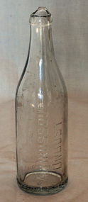 Orbost & District Historical Society
bottle, after 1929
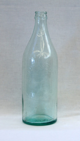
Dross Drossou established a cordial factory in Orbost in the 1930s. He sold his cordial manufacturing business to Phillips and Stone, a Bairnsdale company, in 1948. Glass bottles were refillable until the 1960s, creating a demand for their collection and onsale back to beverage manufacturers via ‘bottle merchants’. A deposit on the bottles was added to all sales as they left the factory. The returned bottles were washed and the old label removed. The inside was cleaned by pushing the bottle onto a revolving brush. The reusing of the bottles went on until the bottle was broken or the top became chipped.This bottle is an example of a product manufactured by a local industry which no longer exists.A clear glass bottle which has a broken top. The bottle is seamed.Base - AGM F516 Front (written sideways) - A DROSSOU ORBOST Bottom (written around whole bottle) This bottle is the property of A Drossou Orbost M bottle drossou container soft-drink -
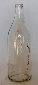 Orbost & District Historical Society
bottle, 1930's
Dross Drossou established a cordial factory in Orbost in the 1930s. He sold his cordial manufacturing business to Phillips and Stone, a Bairnsdale company, in 1948. Glass bottles were refillable until the 1960s, creating a demand for their collection and onsale back to beverage manufacturers via ‘bottle merchants’. A deposit on the bottles was added to all sales as they left the factory. The returned bottles were washed and the old label removed. The inside was cleaned by pushing the bottle onto a revolving brush. The reusing of the bottles went on until the bottle was broken or the top became chipped.This bottle is an example of a product manufactured by a local industry which no longer exists.A clear glass soft drink bottle with a crown seal top. The bottle is seamed.A DROSSOU ORBOST This bottle is the property of A DROSSOU ORBOST Base - AGM F 860 Mbottle container drossou -
 Orbost & District Historical Society
bottle, D. Drossou
Dross Drossou established a cordial factory in Orbost in the 1930s. He sold his cordial manufacturing business to Phillips and Stone, a Bairnsdale company, in 1948. Glass bottles were refillable until the 1960s, creating a demand for their collection and onsale back to beverage manufacturers via ‘bottle merchants’. A deposit on the bottles was added to all sales as they left the factory. The returned bottles were washed and the old label removed. The inside was cleaned by pushing the bottle onto a revolving brush. The reusing of the bottles went on until the bottle was broken or the top became chipped.This bottle is an example of a product manufacture by a local industry no longer existing.Drossou lemonade bottle. Large bottle tinted light blue.Front - D. Drossou, Orbost Bottom G938, 647drossou bottle glass lemonade-bottle -
 Warrnambool and District Historical Society Inc.
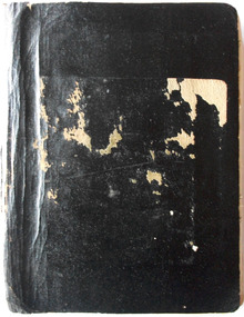
Book - Diary, Diaries of John Ward Vol 1 & Vol 2
They are the handwritten history of Methodism in Warrnambool (produced in the 1930s?) by John Ward, and early settler, North Warrnambool shopkeeper and an ex-councillor and mayor. The books contain over 100 original photographs of people connected to the Methodist Church, both clerical and lay, including women, and other Warrnambool photographs. There is also much written material on all the people connected to the church. The books were given to Warrnambool & District Historical Society Inc in March 2013 by the Uniting Church together with DVD with a digital copy of the photographs and a typed copy of the writings. [Elizabeth O'Callaghan, March 2013]Exercise books: History of Methodism in Warrnambool by John Ward Cat No: WARR These two black exercise books are most precious as they are of high historical significance. They provide an insight into the social and spiritual history of the methodists in Warrnambool Vol 1: 265pp Vol 2: 180pphistory of methodism in warrnambool, john ward -
 Warrnambool and District Historical Society Inc.
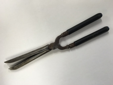
Household, Hair Courlers, Early 20th century
These hair tongs were used to curl or wave hair. They have the name’ Marcel’ on them. In 1872 Francois Marcel Grateau invented a hairstyle called the ‘Marcel Wave’ where women’s hair styles had mostly deep waves rather than curls. The tongs that were held manually and heated and used at home to produce deep waves or curls become a commonplace item in a woman’s home in the late 19th and early 20th centuries. By the 1930s electric hair tongs were introduced but the non-electric ones continued to be used until the 1950s. These hair tongs belonged to a woman from England and would have been used in the 1930s or 40s. They are a good example of the type of household article used by women 70 or 80 years ago and will be useful for display.This is a scissors-like article with wooden handles and metal blades for waving or curling hair. One blade is heavily curved and the other is a solid round shape. The ends of the blades are tapered. The blades were heated over a stove and used manually to enclose part of a woman’s hair to produce waves or curls. The handles were originally polished black and are somewhat rubbed and the blades and other metal parts are a little rusty. ‘Marcel’ ‘12’ hair curling tongs, warrnambool -
 Warrnambool and District Historical Society Inc.
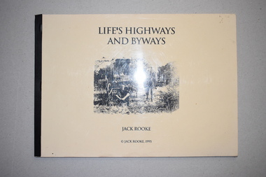
Book, Jack Rooke, Life’s Highways and Byways, 1995
This is a booklet written by Jack Rooke about his life. Born in 1910 Jack Rooke faced early the challenges of living in the bush in the Camperdown and Panmure areas. He describes the difficulties of the small farmer and the tough living conditions. He also records the struggle to survive during the Depression years in the 1930s and his heartache after his farm was burnt out in the Ash Wednesday fires. Rooke’s story mirrors that of many settlers in the Western District in the early to mid 20th century and so he has produced an important social history in a simple but compelling manner. This booklet is of considerable importance as it gives the details of the life of one person facing the challenges of living in the bush in the district around Warrnambool in the 20th century. It is a simple but great social history that should be read by the younger generation today.This is a soft cover book of 40 pages. It has been self-published and home-produced with a buff-coloured cover and a plastic overlay. The cover has a black and white illustration. The pages contain some sketches and black and white photographs. early 20th century settlement in the warrnambool district, history of warrnambool -
 J. Ward Museum Complex
Equipment - 'Electroshock Therapy' Machine, Konvulsator 2077, Post 1930's
Electroconvulsive therapy (ECT) was invented in Italy in the late 1930s. ECT is a medical treatment most commonly used in patients with severe major depression or bipolar disorder that has not responded to other treatments. Psychiatrists had already discovered that inducing seizures could relieve symptoms of mental illness. Before ECT, this was done with the use of chemicals, usually one called Metrazol. More can be read here: http://theconversation.com/electroconvulsive-therapy-a-history-of-controversy-but-also-of-help-70938 This machine was used both at Aradale Mental Hospital and J Ward. The object is significant because it is a well preserved instrument that illustrates the medical apparatus used at both Ararat Mental Hospital and J Ward for the treatment of mental illness.A metal instrument. The front contains three knobs, two switches, and power button. Two fully intact electrical cords - One leads to the paddles used on the patient: One used to attach to the electric source [power point]. Paddles are made of hard plastic and stainless steel metal. The back has a compartment where the paddles can be stored. The top has a carry handle.Manufacturer: Siemens Power supply: 220V 85AC, 50Hzmentalhealth, psychiatrichealth, depression, #bipolardisorder -
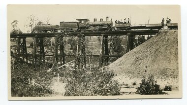 Orbost & District Historical Society
black and white photographs, 20th century
These photographs are probably of bridges on the East Gippsland railway line. 3162.2 is possibly Hospital Creek and 3162.3 possibly Burn Road Newmerella. The Orbost-Bairnsdale railway initially played a crucial role in developing agricultural industries in Gippsland as well as tourism. It opened in 1916 and operated until 1987, principally carrying timber and farming produce. In the early days of the railway's operation dedicated passenger trains ran but these ceased by the 1930s. The line was completely closed to freightage in 1987.The track infrastructure was dismantled in 1994 and has been redeveloped as the East Gippsland Rail Trail.These photographs are associated with the history of the Orbost-Bairnsdale railway line and therefore reflects the role that the rail line played in the social and economic history of Orbost. Three black / white photographs of railway bridges. 3162.1 has a steam train on the bridge. 3162.3 shows three men on the right working at clearing vegetation. 3162.3 has been taken from a height.orbost-bairnsdale-railway east-gippsland-railway bridges-railway -
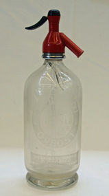 Orbost & District Historical Society
soda syphon bottle, first half 20th century
Dross Drossou established a cordial factory in Orbost in the 1930s. He sold his cordial manufacturing business to Phillips and Stone, a Bairnsdale company, in 1948. Glass bottles were refillable until the 1960s, creating a demand for their collection and onsale back to beverage manufacturers via ‘bottle merchants’. A deposit on the bottles was added to all sales as they left the factory. The returned bottles were washed and the old label removed. The inside was cleaned by pushing the bottle onto a revolving brush. The reusing of the bottles went on until the bottle was broken or the top became chipped. This bottle is an example of a product manufacture by a local industry no longer existing.A clear glass soda syphon bottle. It has a red syphon pump.D.DROSSOU, ORBOST Soda Watersyphon-bottle drosseau -
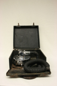 Geoffrey Kaye Museum of Anaesthetic History
Inhaler, Ether, Small
Dr Thomas Small designed this ether anaesthesia and analgesia machine while he was an Honorary Medical Officer at the Royal Women's Hospital in Sydney during the 1930s. The inhaler is compact and portable. Initially, Small experimented with other agents for the relief of labour pain but was not happy with any of them. He also tried various agents on himself, including nitrous oxide/oxygen, chloroform and ethyl chloride. Finally he settled on ether via a Clover inhaler as the best analgesic. This inhaler is only described in use in Australia and New Zealand, although it was used for almost 40 years. Black leather box with leather handle, lockable latches on either side and drop down front case panel containing a metal ether inhaler and length of black corrugated rubber hose with one end attached to the inhaler and the other end open for attaching a mask. The metal inhaler drum is circular and attached to the floor of the case with a small tap/lever to one side and a mixing valve on the top near the hose connection. The lever has incised gradings of quarter increments from 0 to 1. The box is designed for the ether inhaler to be portable.ether, small, thomas, analgesia, obstetrics, anaesthesia, anaesthetic, royal women's, sydney, queen victoria, melbourne -
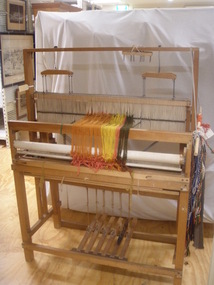 National Wool Museum
Loom
The loom was made by John Charles Mann in the late 1920s-early 1930s for Lilian Joyce Mann. Mr Mann enjoyed woodwork. He died in 1945. Ms Mann was very interested in crafts and owned a shop in Jacob Street which sold handmade soft toys and items woven from the loom, for example table mats. The shop was later bought out by Henry Jacobs and later became Myer. Ms Mann died on the 17th July 2007. Ms Mann was a founding and life member of the Geelong Handweavers and Spinners Guild.W7219 (Mann loom) Lilian Joyce Mann's loom in house Lilian Joyce Mann's loom in houseOxy & Electric Welding Motor & Gehandicrafts, geelong handweavers and spinners guild inc., weaving looms, weaving, mann, mr john charles mann, ms lilian joyce, geelong, victoria -
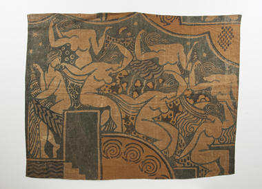 RMIT Design Archives
Textile pieces
Michael O’Connell (1898-1976) arrived in Melbourne in 1920 with no professional training apart from that of a soldier on the Western Front. During the 1920s however he discovered a talent for design and, returning from a visit home to England via France and Italy in 1929, focussed on textile design with his wife Ella. This fragment of a wall hanging shows clear indebtedness to the School of Paris, Matisse in particular, and other designs from the early 1930s indicate that O’Connell was familiar with the work of Raoul Dufy who had created some successful and popular fabric designs for Paul Poiret.Textile piece featuring women and geometric patterntextile design, rmit design archives, mid-century modern -
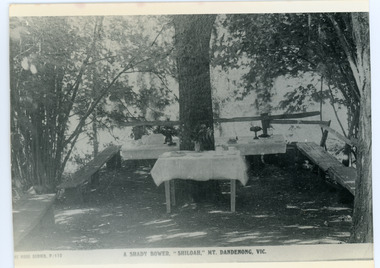 Mt Dandenong & District Historical Society Inc.
Photograph, Tea Tables at "Shiloah"
Originally the home of Isaac Jeeves, brother of Ellis Jeeves, ‘Shiloah’ was enlarged to take guests in the early 1900s. It was situated close to a beautiful fern gully and Isaac and his family capitalised on this by setting out walking tracks through the ferns. They charged 1/- to walk through and this included afternoon tea in a garden setting. ‘Shiloah’ was a popular tourist attraction but the making of the Olinda Creek Road destroyed the fern gullies and, by the 1930s, it was all finished. This photograph shows the tea tables at 'Shiloah' where Selina Jeeves and her daughter Elsie served afternoon tea to visitors.Black and white photograph taken from a Rose Series postcard showing tables set up in an exterior courtyard with bench seating.On front - Rose Series P. 170 A SHADY BOWER "SHILOAH" MT DANDENONG. VIC.shiloah, isaac jeeves the younger, guest house, afternoon tea, ferns, selina jeeves, elsie jeeves