Showing 32039 items
matching buildings
-
 Eltham District Historical Society Inc
Ledger, Eltham Road District. Assessment for the Year ending Oct. 14th, 1861, 1860c
The Eltham Roads Board was established in 1856. This is a unique significant record of early settlers in the Shire of Eltham. One of 6 early rate books. This is among the oldest items in the EDHS collection. An article in the Eltham and Whittlesea Shires Advertiser Friday 21 Nov 1941 Page 5 titled: District's Early History states: "The first rate book which is still in existence at the Shire Office is for the year ending October 14, 1858 and is probably the best record possible to indicate the development of the district. At the time properties were rated as follows: Cultivated land. 6d. per acre; pasture land, 1d. per acre: estimated annual value of buildings, etc., 6d in the (pound). The total amount of rate recorded for the year was (pounds)153/14/8. Properties were described as being situated at Lower Plenty, Yarra Yarra, Eltham, Lower Eltham, Kangaroo Ground, Yarra Flats, Diamond Creek and the Yarra."Ledger with printed columns: Number, Name of Occupier, Description, Where situated, Cultivated land, Pasture land, Estimated annual value of buildings, Rate, Remarks, Arrears collected, excused, unoccupied, uncollected and amount actually collected. Ledger filled out by hand with 185 entries (not alphabetically arranged) and summary section. A number of blank pages are included. Inside cover includes pasted printed note: RATE OF ASSESSMENT AS FOLLOWS: Cultivated land 6d per acre Pasture land 2d per acre Unalienated Pasture Land 8d per Acre Estimated Annual Value of Buildings, &c., 6d. in the Pound eltham roads board, rate book, rate payers, transaction, pioneers, settlers, 1861, assessment ledger, eltham road district, public records office victoria (prov), rate books, shire of eltham archives -
 Bendigo Historical Society Inc.
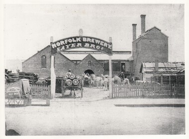
Photograph - WES HARRY COLLECTION: NORFOLK BREWERY, 1860's
... BUILDINGS ...Photograph of Sayer Bros. Norfolk Brewery. A two storied brick building, the section on the right hand side has two chimney stacks. There is a picket fence along the front and a large curved sign over the gateway, Stack of wood are to the left inside the gateway and there are two carts loaded with barrels. Batchelders cart is visible on the left hand side outside the fence.Batchelderbuildings, commercial, norfolk brewery, norfolk brewery, sayer bros., batchelder -
 Bendigo Historical Society Inc.
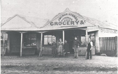
Photograph - HARRY BIGGS COLLECTION: ANCHOR STORES MOORHEAD BROS
... BUILDINGS ...Photograph of a double fronted wooden shop front with a verandah across the whole width. There is decorative fretwork on the gables of the buildings. Above the verandah on the right hand side is a painted sign Anchor Stores, Moorhead Bros. Grocery &c. In front of the verandah there are three women and two men. The name 'Moorhead Bros.' is also on a sign at the side of the verandah. This store is in Sailors Gullybuildings, commercial, anchor stores, anchor stores, moorhead bros, sailors gully -
 Federation University Historical Collection
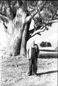
Photograph - black and white, Mr Downing by the Federation University Tree of Knowledge, 1970
Federation University Mount Helen Campus was open to students in 1970. In that year Mr Dowling as photographed beside a big Tasmanian bluegum which was used a the centre Mount Helen Campus concept plan, and later became known as the Tree of Knowledge. Mr Dowling watered the tree after it was planted by his mother, Elizabeth Downing, on Arbour Day 1896. Mrs Downing raised her large family on the site of the Mount Helen Campus, which included an orchard and milking cows. The Tree of Knowledge is actually two trees, the trunks have fused together over time, and there is further evidence of fusion. The Downing farmhouse was situated in the vicinity of the present Administration and Caro Conference Centre buildings and the tree was planted beside the "dunny". It was carefully watered by the nine Downing children from a brick-lined well situated under what is now the Albert Coates Building. As the tree grew to maturity, it was used to hang a meat safe after slaughtering a sheep for the family table. Some years ago, when the foundations were being dug for the E-Building, an old rusted percussion pistol was found. One of Mrs Downing's sons, at that time well into his nineties, remembered getting into trouble for playing with it without permission, and losing it. The land was purchased in 1966 as part of a 241-acre site for Ballarat's new tertiary institution. When the architects and planners inspected the site, they decided "The Big Tree" must remain as a central landmark in preparing the layout of the campus amenities. In 1982, the spread of the tree was 36 metres, girth 7 metres, and height 36 metres. By 2003 the spread was 39.5 metres (N-S) and 35.5 metres (E-W), girth 7.75 metres, and height 42.5 metres. A man in overalls and jacket stands beside the Federation University Tree of Knowledge. Stage one buildings on the Mount Helen Campus are evident in the background.elizabeth downing, downing, tree of knowledge, big tree, mount helen campus, mount helen -
 Rutherglen Historical Society
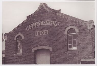
Image, Olive Codling
One of the buildings of the Mount Ophir winery. Photo was taken by Miss Olive Codling, who was a life member of the Wodonga Historical Society. Photograph is believed to have been taken on the occasion of a Tour by the North East Branch, 1st combined meeting.Black and white photograph of a brick building with an ornate roof line. Sign above door reads "Mount Ophir | 1903" This photograph is one of two printed on a single sheet of photographic paper.mt ophir, mount ophir, wine industry -
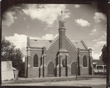 Bendigo Historical Society Inc.
Photograph - PRESBYTERIAN CHURCH, EAGLEHAWK
... BUILDINGS ...Black and white photograph. Brick building with one spire, door each side of front central section, window each side. Decorative brick work at top of walls, on gable. Weatherboard shed at L. House with verandah at R. Inscriptions: in image - 'Eaglehawk Presbyterian Church. Rev Neil Scott. On Back - 'Presbyterian Church'. History of object: James Lerk 2000 'Presbyterian Church, Eaglehawk first constructed in 1859 with alterations by Vahland & Getzechmann and later by Tolhurst in 1871' Photographed for Bendigo Advertiser 1.1.2001 Enlarged digital copy is included.buildings, church, presbyterian church, eaglehawk -
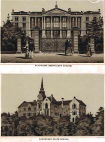 Bendigo Historical Society Inc.
Photograph - SANDHURST BENEVOLENT ASYLUM - SANDHURST STATE SCHOOL, 1888
... BUILDINGS ...Black and White Photos, From the book 'Sandhurst Illustrated' by Schutze, Picture features 'Sandhurst Benevolent Asylum' looking up from Barnard Street, Note the main front gatesand two side gates with large stone pillars to support them. man and lady leaving another couple about to enter the grounds, single lady also having just left the grounds. 'Sandhurst State School' (Camp Hill Primary School) from Rosalind Park, very tall spire on the main building with lookout, Foliage in front are the trees of Rosalind Park.buildings, sandhurst benevolent asylum, anne caudle centre, sandhurst state school -
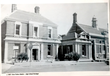 Kew Historical Society Inc
Postcard, Kew Police Station, c.1960
In c.1960, when the photograph was taken on which the postcard is based, both buildings were still owned by the Victorian Government and were a functioning police station and court house. In 1900, ownership of the post office had been transferred to the new Commonwealth Government. In the first decade of the twenty-first century, the police station and court house were offered for sale. They were subsequently purchased and renovated by the City of Boroondara. The Kew Historical Society raised over $5000,000 as a contribution to the restoration.Kew Police Station at left and Kew Court House at right. Monochrome (copied) postcard showing two buildings which are part of a larger complex (once including a post office) built by the Government of Victoria in 1888. The buildings are located at the junction of High Street and Cotham Roads in Kew. The frontages shown face High Street. "c.1960. Kew Police Station. High Street Frontage"kew court house -- high street -- kew (vic.), kew police station -- high street -- kew (vic.), public offices -- kew (vic), queen ann revival -- architectural style -
 Bendigo Historical Society Inc.
Document - H. A. & S. R. WILKINSON COLLECTION: AGREEMENT TO BUILD HOUSE
... buildings ...Agreement made the 3rd of January 1958 between Thomas James Roberts of 1 Ashley Street, Bendigo builder) and Peter William Tieman and Edith Ruby Tieman both of 60 Hodgkinson Street, Bendigo (owners) whereas the owners have land in Specimen Hill Road and have requested he builder to erect a dwelling house thereon. There 8 clauses on the agreement. There is also a sheet detailing the specifications for the build. Price: 2,300 pounds. Also, a paper signed by T. J. Roberts on the 3rd of January 1958 that on completion of contract for new building on block, lot 28, Specimen hill Road, Golden Square for P. W. & E. R. Tieman agreeing to pay H. A. & S. R. Wilkinson the sum of 82 pounds 10 shillings for commission due on such contract.h.a. & s.r. wilkinson, real estate, buildings -
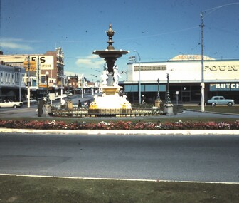 Bendigo Historical Society Inc.
Slide - BENDIGO BUILDINGS
Slide. Bendigo Buildings The Alexandra Fountain, Fountain Plaza Building and Mitchell Street, Bendigo.slide, bendigo, bendigo buildings etc.., bendigo buildings etc.. -
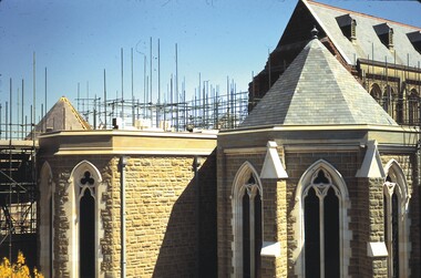 Bendigo Historical Society Inc.
Slide - BENDIGO BUILDINGS & CHURCHES, Nov 1966
Slide. Bendigo Buildings & Churches. Scaffolding can be seen behind the grey/white building.slide, bendigo, bendigo buildings & churches., bendigo buildings & churches. -
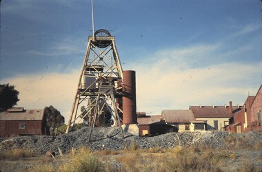 Bendigo Historical Society Inc.
Slide - BENDIGO BUILDINGS & SCENERY, May 1962
Slide. Bendigo Buildings & Scenery. North Deborah Gold Mine with the boiler and other buildings.slide, bendigo, bendigo buildings & scenery., bendigo buildings & scenery. -
 Clunes Museum
Photograph
"KEEBLES"CLUNES BUILDING ON THE CORNER OF BAILEY AND FRASER STREET.THE BUILDING WAS ORIGINALLY THE TELEGRAPH HOTEL.local history, photography, photographs, hotels, telegraph -
 Clunes Museum
Photograph
FINE WORK ON RSL BUILDING, FRASER STREET, CLUNES. THE BUILDING WAS FORMERLY THE E.S.& A. BANKlocal history, photography, photographs, rsl, club rooms -
 Lakes Entrance Historical Society
Photograph - Forestec, Lakes Post Newspaper, 1990
Colour photograph of the completed Forestec building with people in front of building Lakes Entrance Victoriaeducation -
 Glenelg Shire Council Cultural Collection
Painting, Travis Webber, Greenmount, c. 1955
CEMA Art Collection Previously located in History HouseThe painting depicts a large stone building with two smaller buildings in the foreground. Within the foreground is a small patch of dirt and grass with a side view of a small building to the right and a front and side view of a small stone building to the left. In the background is the large building which features two chimmneys. To the left of the building is a leafless tree and pale blue sky. The work has a gold and green frame with glass.Front: "GREENMOUNT" (brown, lower left) TRAVIS WEBBER (brown, lower right) 23 (white sticker attached to glass Back: (No inscriptions) -
 Stawell Historical Society Inc
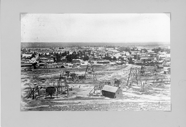
Photograph, Panorama of Stawell from Big Hill with Whims, Poppet Heads & Leaning Shed c 1878
Scene from Big Hill. Market Building in Skene Street at left of Stawell Court House. Businesses at corner of Sloane and Patrick Streets visible. Agnew Drapers store and buildings in upper Main Street visible Shows Mining activity in foreground 1878. Whim in foreground is No7 North Scotchmans and Whim next to that No8 North ScotchmansBlack & White Photograph from Big Hill. Market building left of Court house . Photo shows mining activity in the foreground, Stawell in the background c 1878. refer. Original c 1880 folder (room 2) from Don Rickard & Geoff Oates.stawell, panorama, streetscape, mining -
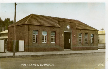 Charlton Golden Grains Museum Inc
Photograph - Postcard, Charlton Post Office c. 1950s, c.1950
Charlton's third Post Office. The first was built in 1878 in Camp St, the second was an ornate brick building built in 1879 on the present site in High St. The third Post Office was built in 1941 as an upgrade to the earlier building.Postcard showing the brick Post Office building on High Street. Three windows on each side of the central entrance. Clock above the entrance. Signage above entrance Charlton Post Office. Telegraph pole and open gate on LH side of picture. Text at the bottom of the postcard says POST OFFICE, CHARLTON. No. 4.POST OFFICE, CHARLTON No. 4.charlton post office, charlton, business -
 Port Melbourne Historical & Preservation Society
Photograph - Foundation stone and plaque, Victorian Seamen's Institute, Beach Street, Port Melbourne, 1888
During demolition of the 1937 Missions to Seamen building in October 1995, this stone was removed intact by developers Mirvac Victoria, and place in the care of the PMH&PS. It is now located as part of the seawall around the car park in front of Nott St. There is a photo of the item on the database, taken in the 1990s while the stone was stored at St Joseph's school in Stokes St.Two photographs taken September 2015 by member Bob Gooding .02 The foundation stone .03 the accompanying plaque - Cornerstone 1888, originally laid at the Victorian Seamen's Institute corner Nott and Beach Street (Fox Hay building today). Was relocated to interior wall near the chapel doors when the new Mission building at corner of Beach Street and Swallow Street was built in 1937.Engraved in gold lettering on a black background: This memorial stone was laid by His Excellenvy Sir Henry B Loch GGMGKCB, Governor of Victoria on Wednesday the 5th day of September AD 1888missions to seamen, sir henry b loch -
 City of Moorabbin Historical Society (Operating the Box Cottage Museum)
Photograph - Photograph, 1908 Excavation commences for the Melbourne Benevolent Society, Cheltenham, 1908 Excavation commences for the Melbourne Benevolent Society, Cheltenham, 1908
Excavating prior to the building of Melbourne Benevolent Society in Cheltenham. The Centre had begun life in 1850 in Melbourne, as the Victoria Benevolent Asylum to "relieve the aged, infirm, disabled and destitute poor of all creeds and nations and to minister to them the comfort of religion" It outgrew its North Melbourne premises so was located to a new site at Warrigal Road, Cheltenham. The foundation stone was laid in 1909, and the main buildings were completed in 1911. In 1970 the benevolent Asylum was re-named Kingston Centre. The photograph is black and white. It's a photo depicting the excavation prior to the building of Melbourne Benevolent Society in Cheltenham. The photograph shows eleven workers at the excavation site. There are two horses with carriages and a large excavating machine to the right of the photograph. benevolent asylum, benevolent society, cheltenham, train, machinery, men, society, horses, kingston centre -
 Vision Australia
Photograph - Image, Free Lending Library of the Blind building opening, 1919
In 1894 the Victorian Braille Writers Association was established in order to create a braille lending library. Such an endeavor also meant a need of space for storage. At first the library was accommodated in the home of Mrs May Harrison before moving to the home of Mrs Dickinson two years later. Eventually, with the help of donors, a space was rented in the Block Arcade to house the 1300+ volumes it held and the yearly increase produced by its braille transcribers. Fortunately in 1918 the Trustees of the Edward Wilson Estate provided 4000 pounds to pay for a new building in Commercial Road. Despite some misgivings from the RVIB at the time, this building was home to both braille volumes and talking books (albums and cassettes) for many years.1 b/w photograph of people on a stageFree Lending Library for the Blind. Senator G. Fairbairn, on behalf of the Edward Wilson Trust, presenting the key of the building to Miss Aston, a Braille reader, representing the Braille Writer’s Association. 26th April 1919. (Label on mount board)tilly aston, braille and talking book library -
 Federation University Historical Collection
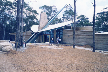
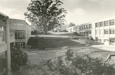
Photograph - Black and White, Mount Helen Campus, 1979
Five black and white images of the courtyard at the Mount Helen Campus of Federation University Australia. .1) View of the courtyard North of 'S' building, towards east .2) View westward, across the courtyard pool (since demolished). The walkway joins the library building (right) and 'S' building. .3) View towards the north-west. Coates Centre ('U' building, formerly Union Building) with Stage Two is on the right. The library is centre. To the left is 'S' building .4) View from the East end of Coates Centre ('U' building) towards 'E' building. -
 Rutherglen Historical Society
Image, Olive Codling
The rear of one of the buildings of the Mount Ophir winery. Photo was taken by Miss Olive Codling, who was a life member of the Wodonga Historical Society. Photograph is believed to have been taken on the occasion of a Tour by the North East Branch, 1st combined meeting.Black and white photograph of brick buildings with corrugated iron water tanks on the roof and an attached covered area presumably for deliveries. This photograph is one of two printed on a single sheet of photographic paper.mt ophir, mount ophir, wine industry -
 Mission to Seafarers Victoria
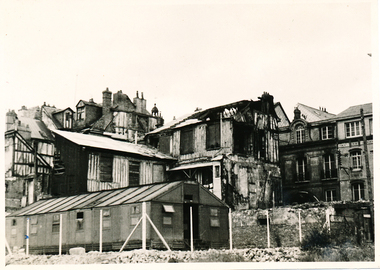
Photograph, Allan Charles Quinn, Old residential district - Rouen, 05 June 1949
This photograph is one of a series taken by Allan Quinn while travelling through France in mid-1946. There are several letters relating to this journey.This is a photograph from the Allan Charles Quinn collection which is a collection of letters and photograph depicting aspects of life at sea for a young man in the era immediately following World War II.A black and white photograph of buildings in Rouen, France, taken on the 5th of June, 1949. The building in the foreground is intact, but most of the buildings behind it have been damaged by bombing.On reverse: ROUEN 5-6-49 handwritten in blue ink. Below this is the mark "It" in pencil.allan-quinn, photograph, rouen, france -
Tatura Irrigation & Wartime Camps Museum
Scarf
Square scarf with wide green border depicting street scene with buildings and port area with 11 ports. KOBE on one of the buildings, Japanese writing on another building.KOBE Japanese writing -
 Hume City Civic Collection
Photograph
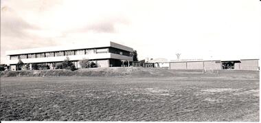
Sunbury Secondary College was established in 1959 and was built on the site of the former rabbit canning factory on the corner of Riddell and Racecourse Roads. Over the years the school has expanded in number and size to cope with the increased needs for secondary education in the area.A black and white photograph of a double storey building and a single storey physical education centre. The buildings are built on a raised embankment with an open grassed section in front of the building.sunbury secondary college, education, schools, george evans collection -
 Kew Historical Society Inc
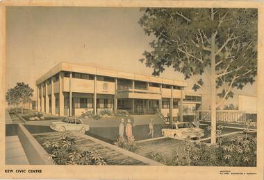
Drawing, AK Lines, Macfarlane & Marshall, Kew Civic Centre, c.1970
The Kew Civic Centre (A K Lines, MacFarlane & Marshall, 1972) was built next to the Kew Civic Hall (A C Leith & Bartlett, 1960) on the site of the former mansion Ordsall (later renamed South Esk). Whereas the entrance to the Civic Hall was positioned off Civic Drive, the main entrance to the Civic Centre faced Cotham Road, as shown in the undated perspective drawing of the proposed building. The Civic Hall was used for public functions and performances, while the Civic Centre was used for civic offices. It also contained the Council Chamber. The building opened in 1972, following the relocation of the councillors and council officers from the former Town Hall in Walpole Street (now a Woolworth's supermarket). Following the amalgamation of the former City of Kew into the City of Boroondara in 1994, the Civic Centre was sold to Trinity Grammar School. The exterior of the Centre has been modified by Trinity Grammar.A report for Heritage Victoria (date) describes how two architectural firms dominated the designs for new civic buildings in Victoria during the post war period. The report claims that: "An interesting sub-theme in the erection of post-war municipal offices in Victoria is that a considerable proportion were designed by the same three or four Melbourne-based architectural firms, who established themselves as the leading specialists in this type of work. The two most prolific firms in this regard were A K Lines, MacFarlane & Marshall, and A C Leith & Bartlett; both, in fact, had made names for themselves as designers of local government offices prior to the Second World War. Lines' office, for example had designed the Eltham Shire Offices in 1941, while Leith's firm had been responsible for the celebrated Heidelberg Town Hall in 1937). Both practices parleyed this early experience into a lucrative post-war career, designing numerous municipals offices well into the 1970s." (Survey of Post-War Built Heritage in Victoria, Built Heritage Pty Ltd, 2010.) The perspective drawing importantly captures the original design and function of the exterior of the building and its public entrance.Hand-coloured perspective sketch of the new Kew Civic Centre, completed in 1972 to designs by A K Lines, MacFarlane & Marshall; and located on the corner of Charles Street and Cotham Road, Kew. The sketch represents the front elevation of the building and its relation to the preexisting Kew Civic Hall at right. The three storey building features strong vertical concrete buttresses that extend across the three levels. KEW CIVIC CENTRE / A K LINES, MACFARLANE & MARSHALLkew civic centre, a.k. lines, macfarlane & marshall, architectural drawings, civic buildings -- kew (vic.), town hall -- kew (vic) -
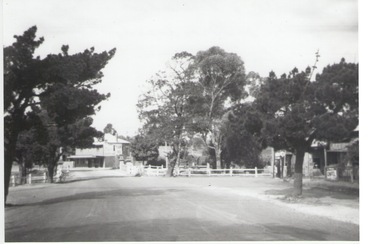 Sunbury Family History and Heritage Society Inc.
Photograph, Rosa McCall, Old Broadmeadows Township, 1949
The former Old Broadmeadows township in the photograph was taken in 1949. The hotel is the two storey building in the middle distance and the former general store is partly hidden by trees on the RHS. The image is looking to the north in Fawkner Street, across the Moonee Ponds Creek. The township is now part of Westmeadows.Old Broadmeadows Township was an important stopping-off point for travellers on their way to Sydney on the Old Sydney Road, (now Mickleham Road) up until 1869 when Sydney Road was finally opened. A print of a non-digital black and white photograph of a small country township with a shop on the RHS and a two storey building in the middle distance. Pine trees are growing on either side of the roadway.old broadmeadows township, townships, moonee ponds creek, westmeadows -
Whitehorse Historical Society Inc.
Article, Kilns Inspected, 1994
Printedd Article in Nunawading Gazette.Article in Nunawading Gazette, Historic Buildings Council believes the old Kilns and Chimneys on the Monier site in Mitcham Road are of State significance and should be retained, but the Company has appealed to Mr. MacLellan to allow them to demolish.Printedd Article in Nunawading Gazette.pottery kilns, monier limited, historic buildings council -
Federation University Historical Collection
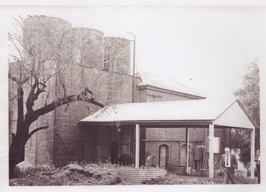
Booklet, Ballarat School of Mines Report to Council on Possible Future Building Developments, 1965, 1965
... Buildings ...A foolscap plan with a number of plans relating to possible future building developments at the Ballarat School of Mines. Includes proposed plan for the former M.B. John Site (neaar brew tower)ballarat school of mines, buildings, building developments, e.j. barker, library, engineering and applied science, gaol residences, trades, ballarat junior technical school, materials testing laboratory, martin report, hickman street