Showing 2265 items
matching map collections
-
 Bacchus Marsh & District Historical Society
Map, Atkins and Clarke Land Sale situate at Bacchus Marsh 1856 Copy 2
This plan of land allotments for sale indicates the property once owned by the Bacchus family in and around the township area of Bacchus Marsh. The Bacchus family sold their property in Bacchus Marsh to John Atkins and Robert Nalder Clarke in March 1851. Atkins and Clarke kept the property for a number of years until April 1856 when these allotments were put up for sale.This plan is almost identical to another copy held by the Bacchus Marsh and District Historical Society, VC Record 707, BMDHS collection). This plan, VC Record 452 Copy 2, contains a less detail than than VC Record 707 Copy 1. For example the selling agents and the surveyor who created the plan are not indicated on this copy of the plan. This copy of the plan does indicate the name Crook Street on the map. As the Crook family were the buyers of the Manor House property and surrounding land from Atkins and Clarke in 1856 it suggests that this copy is a later one of the earlier version. It is unlikely that the Crook family would have had the adjacent street named after them prior to purchasing the house and property. This is a very early land sales plan for the township of Bacchus Marsh and it therefore provides some clues as to how the early urban development of the township took place. Upon seeing the map in 1911 Bacchus Marsh Express newspaper editor Christopher Crisp wrote "The sale appears to have created the present township, which had a nucleus in earlier times further east", Express, 30 September, 1911, page 3. A single page paper map showing a portions of land available for sale in Bacchus Marsh in 1856. The subdivided land shown was owned by John Atkins and Robert Nalder Clarke, but previously owned by the Bacchus Family and was in and around their Manor House (Mansion) property in Bacchus Marsh.There are 5 portions of land further divided into numerous small portions. The land for sale is bounded by the present day streets of Main Street, Young Street, McFarland Street, Morton Streets, Crook Street, and part of the eastern section extends to the Lerderderg River. Scale: 4 chains to 1 inch. The map is pasted into a bound volume containing 76 maps or plans in total. High resolution digital image stored on BMDHS computer network. Plan of the first portion of land. The property of Messers Atkins and Clarke situate at Bacchus Marsh.land sales, land sales bacchus marsh, manor house bacchus marsh, crook family bacchus marsh -
 Bendigo Historical Society Inc.
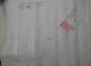
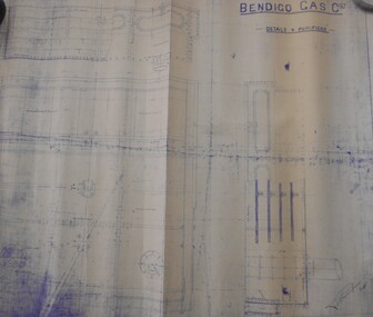
Map - BENDIGO WEEROONA GASWORKS MAP/PLAN COLLECTION: CROWN ALLOTMENTS 13/14, 1942
... BENDIGO WEEROONA GASWORKS MAP/PLAN COLLECTION: CROWN...MAP Bendigo gasworks gas company plans Map: crown ...Map: crown allotments 13 and 14, Sec. E. City of Bendigo, Parish of Sandhurst. Shows site of Bendigo Gasworks. Prepared by Garnel Gordon Birch Surveyor, 12.6.1942map, bendigo, gasworks, gas company, plans -
 Bendigo Historical Society Inc.
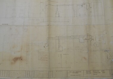
Map - BENDIGO WEEROONA GASWORKS MAP/PLAN COLLECTION: COMPRESSOR PLAN LAYOUT, 15.2.1971
... BENDIGO WEEROONA GASWORKS MAP/PLAN COLLECTION: COMPRESSOR... Corporation Development Department. Map BENDIGO WEEROONA GASWORKS MAP ...Plan showing compressor plan layout at Bendigo Weeroona Gasworks. Prepared by Gas and Fuel Corporation Development Department.plan, bendigo, bendigo weeroona gas works, gasworks, public utility, gas and fuel corporation -
 Bendigo Historical Society Inc.
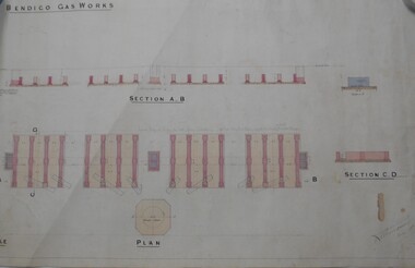
Map - BENDIGO WEEROONA GASWORKS MAP/PLAN COLLECTION: SECTION OF BENDIGO GASWORK, 1889
... BENDIGO WEEROONA GASWORKS MAP/PLAN COLLECTION: SECTION OF... December 18th. , 1889. Map BENDIGO WEEROONA GASWORKS MAP/PLAN ...Plan: showing section of Bendigo Gasworks, Hand coloured plan. Dated December 18th. , 1889...? Thompson, Dec. 18th., 1889bendigo, gasworks, plan. -
 Bendigo Historical Society Inc.
Map - BENDIGO WEEROONA GASWORKS MAP/PLAN COLLECTION: FOUNDATION DETAILS, 1942
... BENDIGO WEEROONA GASWORKS MAP/PLAN COLLECTION: FOUNDATION... GASWORKS MAP/PLAN COLLECTION: FOUNDATION DETAILS ...Plan: Bendigo Weeroona Gasworks. Plan shows foundation detail 140,000 c. ft. gasholder, Bendigo, 1942. Prepared by N.J. Hurll & Co. ( Vic ) Pty. Ltd., King St., Melbourne.plan, bendigo, bendigo weeroona gas works, gas works -
 Bendigo Historical Society Inc.
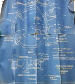
Map - BENDIGO WEEROONA GASWORKS MAP/PLAN COLLECTION: DETAILS FOUR PURIFIERS, 1889
... BENDIGO WEEROONA GASWORKS MAP/PLAN COLLECTION: DETAILS FOUR... Plan/map: Bendigo Weeroona Gaswork, plan showing details four ...Plan/map: Bendigo Weeroona Gaswork, plan showing details four purifiers. Plan signed by? Thompson engineer, dated 1889. Written on bottom RH: this is one of the drawings referred to in my contract dated ... (undated).plan, bendigo, bendigo weeroona gas works, gasworks, thompson -
 Bendigo Historical Society Inc.
Map - BENDIGO WEEROONA GASWORKS MAP/PLAN COLLECTION: LAY OUT OF NORTHERN SECTION, 1982
... BENDIGO WEEROONA GASWORKS MAP/PLAN COLLECTION: LAY OUT OF... to read, very faded. Map BENDIGO WEEROONA GASWORKS MAP/PLAN ...Plan of Bendigo Weeroona Works, works lay out northern section. Written on bottom of plan: this tracing from old drawing …. (?) difficult to read, very faded.plan, bendigo, bendigo weeroona gasworks, gas works -
 Hymettus Cottage & Garden Ballarat
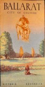
Work on paper - Tourist Brochure, Ballarat, City of Culture
Single sheet folding inwards with photographic illustrations and accompanying text and district map. Measurements vary as listed folded and unfolded.ballarat, culture -
 Falls Creek Historical Society
Document - Bob Hymans' Correspondence Collection
Bob (Herman) Hymans (a former member of the Royal Netherlands Navy) was born in Bloemendaal, Holland on 30th September 1922. During World War II he fought against the Japanese in the Dutch East Indies (now Indonesia) and was imprisoned in Changi and on the Burma Railway. After gaining qualifications as a Ski Instructor, Bob arrived in Falls Creek in July 1950. Working as an Instructor and Supervisor at Bogong Lodge, Bob decided his future was in accommodation. He was successful in negotiating an indenture for land from the State Electricity Commission (SEC). It took Bob two years to build his Grand Coeur Chalet but, tragically, it was burned down in August 1961. Bob also built the first Chairlift in Australia. This was a single chairlift and the structure was built from wooden electricity poles. He was constantly full of new ideas and proposals for the village. Bob Hymans died on 7th July 2007. This collection of between 200 - 300 items includes documents from Bob Hymans' correspondence whilst he was pioneering developments at Falls Creek, Victoria. It consists of Aerogrammes, telegrams, maps and communication with American and French companies related to issues ranging from licences, ski tows, international visits and developments at Falls Creek.This Collection is significant because it contains correspondence records of a Falls Creek pioneer who played an active role in the development of Falls Creek Village, including the first ski lift as well as Grand Coeur and Four Seasons lodges.A collection of letters and other documents from the personal records of Bob Hymansbob hymans, falls creek pioneers -
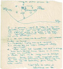 Falls Creek Historical Society
Album - Bob Hymans' Photos - Note
Bob (Herman) Hymans (a former member of the Royal Netherlands Navy) was born in Bloemendaal, Holland on 30th September 1922. During World War II he fought against the Japanese in the Dutch East Indies (now Indonesia) and was imprisoned in Changi and on the Burma Railway. After gaining qualifications as a Ski Instructor, Bob arrived in Falls Creek in July 1950. Working as an Instructor and Supervisor at Bogong Lodge, Bob decided his future was in accommodation. He was successful in negotiating an indenture for land from the State Electricity Commission (SEC). It took Bob two years to build his Grand Coeur Chalet but, tragically, it was burned down in August 1961. Bob also built the first Chairlift in Australia. This was a single chairlift and the structure was built from wooden electricity poles. He was constantly full of new ideas and proposals for the village. Bob Hymans died on 7th July 2007. This photo collection belonged to Bob Hymans and primarily documents the building of his chalet, Grand Coeur.This album is significant because it documents the building of an important chalet at Falls Creek and the work of one of its pioneers.A sketch map and notes written in blue inkbob hymans, grand coeur chalet, falls creek pioneers -
 Falls Creek Historical Society
Document - Information Bulletin April 1961
Bob Hymans Collection Bob (Herman) Hymans (a former member of the Royal Netherlands Navy) was born in Bloemendaal, Holland on 30th September 1922. During World War II he fought against the Japanese in the Dutch East Indies (now Indonesia) and was imprisoned in Changi and on the Burma Railway. After gaining qualifications as a Ski Instructor, Bob arrived in Falls Creek in July 1950. Working as an Instructor and Supervisor at Bogong Lodge, Bob decided his future was in accommodation. He was successful in negotiating an indenture for land from the State Electricity Commission (SEC). It took Bob two years to build his Grand Coeur Chalet but, tragically, it was burned down in August 1961. Bob also built the first Chairlift in Australia. This was a single chairlift and the structure was built from wooden electricity poles. He was constantly full of new ideas and proposals for the village. Bob Hymans died on 7th July 2007. This Collection of documents and letters tells the story of Bob's endeavours to develop Falls Creek into the ski village it is today.This letter is significant because it documents developments made or endorsed by the Falls Creek Tourist Area Management Committee.An information bulletin published by the Management Committee. Information included is the release of a new subdivision map, establishment of a Ski Rescue Service and notification that Bob Hymans' would not be in operation for the coming season,falls creek tourist area management committee, preparations for winter season 1961 -
 Bendigo Historical Society Inc.
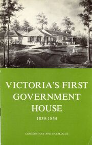
Book - STRAUCH COLLECTION: VICTORIAS FIRST GOVERNMENT HOUSE
... black and white photographs and a map. Book STRAUCH COLLECTION ...A prefabricated, two-bedroom, wooden cottage brought from England by Victoria's first governor, Charles La Trobe. It was erected on his estate "Jolimont" near the current MCG.Booklet, Victoria's First Government House 1839 - 1854 Commentary and Catalogue Fourth edition 1974 National Trust of Australia. Contains black and white photographs and a map.australia, history, government, australia - history - government -
 Warrnambool and District Historical Society Inc.
Map - Tourist Map Collection: Warrnambool & District Tourist Maps, Philprint, Warrnambool
... Tourist Map Collection: Warrnambool & District Tourist Maps...This is a diverse collection of Tourist Maps...This is a diverse collection of Tourist Maps ...This is a diverse collection of Tourist Maps for the Warrnambool & District area. [.1] From information on this guide it dates from the mid 1970's. It appears to not have been commercially printed and includes details of attractions no longer operating in Warrnambool such as Warrnambool Aquarium and the Oasis Reptile Park and Zoo. [.2] Commercially printed Warrnambool tourist map (c mid 1980's) surrounded by advertisements for local businesses. [.3] Commercial printed December 1991 tourist map of Warrnambool and District includes a competition entry form [.4] Commercially printed tourist map aimed at children [.5] Walking map of Warrnambool and District [.6] Commercially printed Warrnambool tourist map (c mid 1980's) surrounded by advertisements for local businesses. This collection of maps from the mid 1970's to early 1990's gives an insight into what was available to assist tourists find their way around Warrnambool and District. They include advertisements for business operating during this period and include lists of available accommodation, eateries, and tourist attractions.[.1] Tourist Attractions In and Around Warrnambool two foolscap pages with two sides of type written information of local and district attractions. There is a Warrnambool City map with points of interest marked and a hand drawn district map; [.2]Commercially printed grid map of Warrnambool City surrounded by advertisements from local businesses. Reverse side has a district map and a map of the Warrnambool CBD surrounded by advertising. [.3] Brochure including small grid maps of Warrnambool and district listing accommodation providers and places of interest. Stylised blue & bright green design of Norfolk pines and sea. [.4] Children's treasure hunt map to Warrnambool There are two examples, one with blue edging (Jan 1986) and one with red edging (Aug 1993) Both have a circular logo with a stylised whale and lighthouse [.5] Walking maps of Warrnambool blue printed photo of four tourists walking coastline on the front cover. [.6] Commercially printed grid map of Warrnambool with a bright yellow inset of Warrnambool CBD main shopping centre. The map is surrounded by advertising for local businesses.warrnambool, tourist maps, warrnambool businesses, warrnambool accommodation -
 National Vietnam Veterans Museum (NVVM)
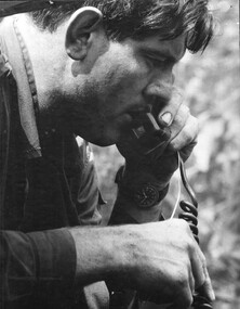
Photograph, Gibbons, Denis, Radio Instructions
Denis Gibbons (1937 – 2011) Trained with the Australian Army, before travelling to Vietnam in January 1966, Denis stayed with the 1st Australian Task Force in Nui Dat working as a photographer. For almost five years Gibbons toured with nine Australian infantry battalions, posting compelling war images from within many combat zones before being flown out in late November 1970 after sustaining injuries. The images held within the National Vietnam Veterans Museum make up the Gibbons Collection. A black and white photograph of a platoon commander with 9th Battalion, Royal Australian Regiment, radioing map reference corrections to the forward artillery observer attached to his company Headquarters, NVA/VietCcong, during a search and destroy mission.photograph, 9th battalion, royal australian regiment, nva/vc, gibbons collection catalogue, photographer, vietnam war, denis gibbons, platoon commander, search and destroy mission -
 Bendigo Military Museum
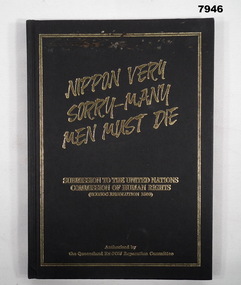
Book - POW SUBMISSION, Queensland Ex-POW Reparation Committee, "NIPPON VERY SORRY - MANY MEN MUST DIE", 1990
Refer Cat. No. 7944. Item in the collection of "Arthur E. Tranter" V50166 - VX52843 2/29th Bn. P.O.W. From front cover "NIPPON VERY/ SORRY - MANY/ MEN MUST DIE" "SUBMISSION TO THE UNITED NATIONS/ COMISSION OF HUMAN RIGHTS/ (ECOSOC RESOLUTION 1503)". "AUTHORISED BY / THE QUEENSLAND EX- POW REPARATION COMMITTEE".hard cover book. Cover - cardboard with black colour buckram adhered cover with gold colour print front and spine. 123 pages - cut, plain, off white colour paper. Illustrated black and white phtographs, documents and maps. End papers - front and back - illustrated with a diagram of the "BURMA- SIAM RLY".publications, book, military history, ww2, tranter, pow's -
 Bendigo Military Museum
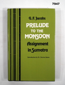
Book - AUTOBIOGRAPHY, G. F. Jacobs, "PRELUDE TO THE MONSOON ASSIGNMENT IN SUMATRA", 1982
Refer Cat No. 7944. Item in the collection of "Arthur E. Tranter" V50166 - VX52843, 2/29th Bn P.O.W.Hard cover with dust cover. Hard cover - cardboard, with black colour buckram on spine, green colour paper adhered cover. Gold colour print on spine. Dust cover - paper, with glass finish. Black and white colour print on front, spine and back. Front and back flap information. 249 pages, cut, plain, off white colour paper. Illustrated - black and white photographs and map.books, miliitary history, ww2, sumatra, autobiography -
 Bendigo Historical Society Inc.
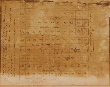
Document - HARRIS COLLECTION: HAMS SQUATTING MAP OF VICTORIA, PORT PHILLIP DISTRICT, NSW
... HARRIS COLLECTION: HAMS SQUATTING MAP OF VICTORIA, PORT.... Written 1959, 53. Document HARRIS COLLECTION: HAMS SQUATTING MAP ...Thomas Ham was a cartographer, engraver, lithographer and publisher in Victoria and Queensland. He compiled and printed several editions of his squatting map, beginning with A map of Australia Felix in 1847 and changing its title to Ham's squatting map of Victoria in 1851. The 1851 edition was accompanied by a key listing the names of all the squatters within squatting districts and counties. Later editions show the existing counties, but some areas of Gippsland and the Australian Alps are still described as 'unsurveyed country'. (State Library Victoria https://www.slv.vic.gov.au/squatting-map-victoria)Folding map enclosed in burgundy cover. Map backed by cloth and bound. Rare, early map of Victoria and neighbouring Port Phillip District of New South Wales. Written on bottom RH corner of map: Ham's Squatting Map of Victoria ( Port Phillip District, New South Wales ) carefully corrected to this date from the Colonial Government Surveys, Crown Lands, Commissioners & Explorers Maps, Private Surveys & c. Respectfully inscribed (with permission ) to His Excellency Sir Chas A. Fitz-Roy Knt, Governor of New South Wales &c &c by his Obedient Servant, The Compiler, 1851. Compiled, engraved and published by Thomas Ham, Melbourne. Proposed and original boundary ( in legend) have been coloured in in blue and pink ink ( later addition ?) Number on map show 'reference to proprietor's Printed on back of map ' J.G. AD 1852, with two cross hatched decorations and two hearts entwined. On other back panel in pencil enclosed in a drawn frame ' G.S.H., 1889, Axedale' (George Harris, Axedale, belongs in Harris Collection) Stamped in purple ink 'Royal Historical Society of Victoria, Bendigo Branch. Written 1959, 53.map, victoria, squatting map -
 Bendigo Military Museum
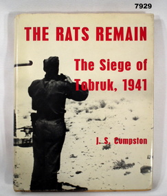
Book - TOBRUK WW2, J.S. CUMPSTON, "THE RATS REMAIN: TOBRUK SIEGE 1941", 1966
Item in the collection re: "William Anthony (Bill) THEODORE DSM". Refer Cat. No. 7926P for his service record.HARD COVER BOOK WITH DUST COVER. Hard cover - cardboard with adhered yellow colour buckram over. Red colour print on front and spine with black and white photograph illustration from front to back of a battle scene. Dust cover - Paper, off white with print and illustration same as above. 256 pages - cut plain, white glossy paper. This is a pictorial book. Illustrated black and white photographs and maps. End papers - front and back - colour wrap of "TOBRUK DEFENCE (12 Jan 1941)". books, tobruk, ww2, william anthony theodore -
 Warrnambool and District Historical Society Inc.
Booklet - Booklet Collection: City of Warrnambool Tourist Guides, Collett, Bain and Gaspar, Warrnambool
This is a collection of sixteen tourist guides dating from the mid 1970's to 2013. These contain listings of businesses, accommodation, eateries and events in Warrnambool and district. They also include maps of Warrnambool and surrounds, advertising and photographs of various attractions. While mainly covering Warrnambool a small number of the guides cover the South West Region. These directories have mainly been published by the Warrnambool City Council and are a selection of the types of information provided to visitors at the Tourist information centre during this time period.These tourist guides give snapshots of the City of Warrnambool for the years covered and will be useful for research.[.1] An 8 page paper booklet with black printing and a black & white photo of the pond at the Botanical Gardens on the front cover. [.2] two photocopied A4 black and white pages from the book "On the Trail" K Winser 1956 (Main Roads of Australia) [.3] A trifold colour brochure with a stylised map of the coast on the yellow and blue front cover. The inside has stylised colour drawings on Warrnambool attractions. The rear cover has coloured photographs of bush, Liebig Street and Fletcher Jones gardens [.4] A trifold black and white brochure with a black line drawing of a whale on the front cover. [.5] A trifold white card with mauve printing. The front cover has a line drawing of the former Timor Street post office and a map of businesses and landmarks in Timor Street. The reverse side contains a brief history of Warrnambool. [.6] A 98 page stapled booklet with a foreword by Vanda Savill. There are 4 pages of coloured photographs. The remainder are black and white photographs. The front cover is purple with white writing in the lower third. There is an outline of the coast and five colour photographs of district attractions. The inside middle page has a map of the Western wonderland region. The content covers towns in this area. Content relating to Warrnambool is in the last six pages. [.7] Twelve loose photocopied black and white pages. The front cover has the Warrnambool Premier Town 1988-1991 logo and a photo of a Southern Right Whale and calf. The bottom right hand corner has a Standard Warrnambool logo. [.8] 44 page booklet printed with blue ink. The staples have been removed. The glossy front cover has blue printing with a coloured photo of Flagstaff Hill Maritime Village pond. The centre pages has a fold out map of the City of Warrnambool. The rear cover has photos of The Twelve Apostles and Hopkins Falls. [.9] 4 loose photocopied pages with Warrnambool Library and Corangamite Regional Library Service Warrnambool City Library black ink stamps. The front page line drawing illustrations of Warrnambool attractions [.10] A single sheet of glossy white paper folded in half to make four pages. The front page has a Warrnambool premier town logo 1979-1982 and blue printing and a visitor survey. [.11] A conference pack of light card folded to make a pocket containing three brochures, a shipwreck coast tourist directory and a Australian Heritage Parks Association conference program dated 24 to 27 May 1992. The front cover of the pack has green writing over a stylised upward arrow. There is a City of Warrnambool logo in the top right hand corner and two film strips diagonally across the cover containing photographs of Warrnambool. The rear cover has a coloured Warrnambool Premier Town logo. [.12] A 63 page stapled booklet with coloured photographs of Warrnambool. The front cover has black writing on white background. There is a coloured photograph of Flagstaff Hill in the middle of the cover and a Warrnambool City and Visit Victoria logos on the lower edge. The middle pages has a coloured of the city of Warrnambool with an inset map of Allansford. [.13] A single large sheet of white paper folded in ten to make a brochure. The front cover has black printing. The rear cover has a purple ink stamp for the City of Warrnambool Tourist Information Centre. When folded out the reverse side has a green, grey and white map of the South West Region of Victoria. [.14] A 48 page colour booklet on glossy paper. The front cover has white writing on a blue background and includes photographs of the Twelve Apostles, the Promenade walk, Flagstaff Hill and a southern right whale's tail. The rear cover has photographs of The Twelve apostles, a passenger train from Melbourne passing the Lake Pertobe playground, and a rural scene. There is white writing and a white Warrnambool City logo on a blue background. The centre pages have a stylised green and blue map of the city of Warrnambool. [.15] A 48 page colour booklet on glossy paper. The front cover has white writing over colour photographs of two people at a lookout, Flagstaff Hill, three southern right whales and a child at the Lake Pertobe playground. The lower edge has blue upper case writing on a white background. The rear cover has a colour photograph of the Twelve Apostles. The lower white border on the rear covers has a a blue and green City of Warrnambool logo and blue writing. The centre pages have a stylised green and blue map of the city of Warrnambool. [.16] A 64 page colour booklet on glossy paper. The front cover has black writing on a black background and there is a photograph of a southern right whale's tail. The lower edge has the Warrnambool City and Visit Victoria Logos. The centre pages have maps of Warrnambool and surrounds. [.1] This week in Warrnambool Vol 2 No. 5 Thurs 1st Feb. For the time of your life [.2] Warrnambool Way [.3] Warrnambool The Holiday Host on the South West Coast with compliments City of Warrnambool and Warrnambool Chamber of Commerce [.4] MMI Insurance presents Whales Giants of the Deep Whale Watcher's Logbook Warrnambool [.5] Warrnambool History began in Timor Street [.6] Western Wonderland Tourist Association [.7] A Premier Arrow Tour of Warrnambool Victoria's Premier Town Australia's Southern Right Whale Nursery [.8] Warrnambool The Heart of Victoria's Great Southwest Visitor's Handbook [.9] What to see in Warrnambool Victoria's Premier City 1979-1982 [.10] Win a Free Holiday & $200 Cash in Victoria's Premier Town [.11] Advancing Warrnambool together! [.12] Great Ocean Road Warrnambool Official Visitor Guide [.13] Tourist guide to the South West Region Victoria All it needs is you [.14] Warrnambool visitor guide 2005 the great ocean road experience attractions accommodation entertainment dining [.15] Warrnambool Visitor Guide 2006 the great ocean road experience Attractions Accommodation Entertainment Dining [.16] Official Visitors' Guide Warrnambool Victoria Australia Discover the Great Ocean Road warrnambool, warrnambool tourist guides -
 Federation University Historical Collection
Map, Ballaarat Gold Field, 1861, 1861
... of the 1861 map reproduced from a copy in their collection. ballarat ...A party of surveyors camped by Yuille's Swamp (later Lake Wendouree) and surveyed the countryside for a map to be produced by the Geological Survey of Victoria. In November 2004 the Central Highlands Regional Library presented a special edition of 200 copies of the 1861 map reproduced from a copy in their collection. Original 1861 map of Ballarat showing streets and leads. Blue dots indicate gold leads, and red lines indicate auriferous quartz reef and outcrops of quartz veins."Compiled & Drawn from the Survey of Mining Surveyors Davidson, Fitzpatrick and Cowan & the Plans in the Surveyor General's Office by J. Brahe, 21st October 1861. R. Brough Smyth, Secretary for Mines. The Honourable J.B. Humffray, M.L.A. Commr of Mines.”ballarat, map, ballarat east, lake wendouree, survey, mines, robert davidson, ballarat gold field 1861, yuille's swamp, wendouree swamp, little bendigo diggings, gold leads, old post office hill, specimen hill, bakery hill, black hill, dead horse creek, brown hill, pennyweight hill, clayton hill, soldiers hill, golden point, gum tree flat, white flat, poverty hill, chinese village, robert brough smyth, ballarat map 1861, ballaarat vineyard, dead horse gully, deadhorse creek, invermay, black hill flat, gaelic church, police reserve, magpie range, dalton's flat, caadian lead, rifle butts, powder magazine, bathing house, government camp, gold office, chinese, llanberrris, victoria theatre, charlie napier hotel, united states hotel, grape's hoel, clayton's hill, cattleyard hill, free trade hotel, esmond lead, bakery hill, black hill lead, juvenile reformatory, ballarat orphanage, lady barkly lead, triffet's slaughter yard, little bendigo, melbourne road, t. cowan, thomas cowan -
 Bendigo Historical Society Inc.
Book - STRAUCH COLLECTION: WHROO CEMETERY VICTORIA
... containing list of interments in Whroo Cemetery with maps ...Although the first recorded burial at Whroo (7 km south of Rushworth) was in 1858, it is believed earlier unrecorded burial took place. The official cemetery was established in 1860 and contains approx. 400 burials although many are unmarked. There is also a Chinese section as in 1863 17% of the population was Chinese in 1863.Red Spring binder containing list of interments in Whroo Cemetery with maps & illustrations.James & Nicola Thomsonplace, cemetery, whroo, victoria-whroo-rusthworth-history-cemetery -
 Bendigo Military Museum
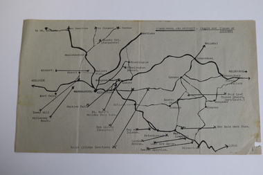
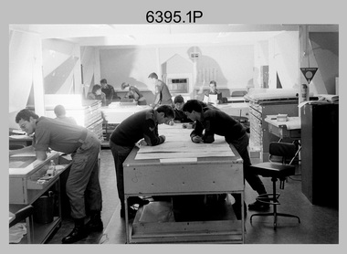
Photograph - Army Survey Regiment – Map Production, Fortuna, Bendigo, 1986
These 17 photographs of the Army Survey Regiment’s map production and facilities were taken at Fortuna Villa, Bendigo, April 1986. Photos .1P to .3P were taken in Cartographic Squadron’s Correcting Section in the Attic. located on the top floor of Fortuna Photos .4P to .5P were taken in Cartographic Squadron’s Proving Section, located in the Ballroom also on the top floor facing the lake. The technicians were probably involved in a rapid response map production, as they all were wearing field uniforms. As ‘Regiment Overcrowding’ is annotated on the plastic sleeve holding the negatives, it seems the photos were taken when the unit was at its capacity to demonstrate the lack of suitable work areas. The Army Survey Regiment’s Duty Room, RAP and Carpark appearing in Photo .10P was probably taken from the top steps near the SGT’s accommodation block. Two of the photos in this set are also published in item 6096.5P.This is a set of 17 photograph of Map Production and car park was taken at the Army Survey Regiment, Fortuna, Bendigo, in April 1986. The black & white photographs are on 35mm negative film and are part of the Army Survey Regiment’s Collection. The photographs were scanned at 96 dpi. .1) - Photo, black & white, 1986. Correcting Section, Attic: L to R: CPL Andy Lucas, SPR Chris Gordon, unidentified, SPR Jan (Crighton) Minchin, CPL Robin Marshall, CPL Frank Downie, SPR Gayle Humphrey, unidentified (x2), Jason Wells at rear. .2) - Photo, black & white, 1986. Correcting Section, Attic: L to R: CPL Andy Lucas, SPR Chris Gordon, unidentified, SPR Jan (Crighton) Minchin, CPL Robin Marshall, CPL Frank Downie, SPR Gayle Humphrey, unidentified, Jason Wells, unidentified. .3) - Photo, black & white, 1986. Correcting Section, Attic: L to R: CPL Andy Lucas, CPL Robin Marshall, SPR Chris Gordon, unidentified, CPL Frank Downie, SPR Gayle Humphrey, unidentified, SPR Jan (Crighton) Minchin at rear., Jason Wells on phone. .4) & .5) - Photo, black & white, 1986. Proving Section, Ballroom: On left front to back: SGT Alan Staley, SGT Roger Rees, SGT Greg Anderson. On right front to back: SGT Denis McCarthy, SGT Tim Allanson, SSGT Adrian ‘Charlie’ Creedy. .6) - Photo, black & white, 1986. Records & Proofing buildings. .7) - Photo, black & white, 1986. Technical Services temporary buildings. .8) - Photo, black & white, 1986. Q-store and transport buildings. .9) - Photo, black & white, 1986. Technical Services temporary buildings in front of transport compound. .10) - Photo, black & white, 1986. Army Survey Regiment Duty Room, RAP and Carpark at Fortuna. .11) - Photo, black & white, 1986. Records & Proofing buildings. .12) - Photo, black & white, 1986. Other Ranks (OR’s) car park and barracks with kitchen in background. .13) - Photo, black & white, 1986. Other Ranks kitchen, parade ground and SGT’s/Officers barracks in background. .14) - Photo, black & white, 1986. Fortuna Villa taken from the steps near the SGT’s accommodation block. .15) - Photo, black & white, 1986. Fortuna Villa taken from the steps near the OR’s s accommodation block. .16) - Photo, black & white, 1986. Fortuna Villa taken from the roadway near the OR’s accommodation block. .17) - Photo, black & white, 1986. 20’ x 30’ Army tents set up on the basketball court..1P to .17P – ‘Regiment Overcrowding’ and the date are annotated on the plastic sleeve.royal australian survey corps, rasvy, army survey regiment, army svy regt, fortuna, asr -
 Whitehorse Historical Society Inc.
Map - Civic Map, Subdivision of Village of Springfield, 1861
... Collection of Maps, LaTrobe Library"... subdivision map of the Nunawading area, part of the Vale Collection ...Map of the subdivision of the Springfield Estate, Nunawading, 1861. The Springfield Estate was located in the Northwest corner of Whitehorse Road and Springvale Road.Map of the subdivision of the Springfield Estate, Nunawading, 1861. Springfield Estate was located in the Northwest corner of Whitehorse Road and Springvale Road.non-fictionMap of the subdivision of the Springfield Estate, Nunawading, 1861. The Springfield Estate was located in the Northwest corner of Whitehorse Road and Springvale Road.springfield estate, whitehorse road nunawading, springvale road nunawading -
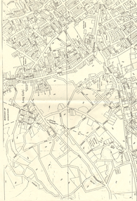
 Bendigo Historical Society Inc.
Map - LONG GULLY HISTORY GROUP COLLECTION: MAP OF LONG GULLY/CALIFORNIA GULLY AREA
... LONG GULLY HISTORY GROUP COLLECTION: MAP OF LONG GULLY... are also shown. Map LONG GULLY HISTORY GROUP COLLECTION: MAP ...BHS CollectionTwo copies of a map, printed on yellow paper, of the Long Gully/California Gully Area. It shows Eaglehawk Road from Craig Street then Mr Korong Road,to the Murray Valley Highway to just past Avenue Street. Sandhurst Road and Holmes Road are to the right. To the left is California Gully Road. Water Supply Purposes Reserve, Mental Hygiene Authority, Comet Hill State School Reserve, Agricultural Showgrounds and Recreation Reserve, Rubbish Reserve and two un-named State Schools are shown. Some contours are also shown.bendigo, history, long gully history group, the long gully history group - map of long gully/california gully area -
 Bendigo Historical Society Inc.
Map - LONG GULLY HISTORY GROUP COLLECTION: MAP OF LONG GULLY AREA
... LONG GULLY HISTORY GROUP COLLECTION: MAP OF LONG GULLY AREA.... Map LONG GULLY HISTORY GROUP COLLECTION: MAP OF LONG GULLY ...BHS CollectionTwo copies of a map, printed on yellow paper, of the Long Gully Area. It shows Eaglehawk Road from Barnard Street to a little past William Street.bendigo, history, long gully history group, the long gully history group - map of long gully area, victorian water supply reserve, borough of eaglehawk -
 Greensborough Historical Society
Document - Planning Document, Diamond Village Apartment Complex, 2019
A collection of documents discussing opposition to the Diamond Valley Apartment Complex, a high-rise apartment development planned for Nepean Street Greensborough.13 pages of Text with coloured photographs and mapdiamond village apartment complex, building permits, nepean street greensborough -
 Bendigo Historical Society Inc.
Book - STRAUCH COLLECTION: RESEARCHING YOUR GERMAN ANCESTORS
... ancestors with illustrations and a map. Book STRAUCH COLLECTION ...BHS CollectionManilla folder containing information on researching your German ancestors with illustrations and a map.genealogy, family, german, genealogy-german -
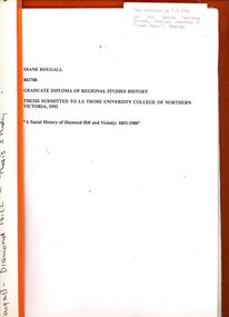 Bendigo Historical Society Inc.
Book - STRAUCH COLLECTION: A SOCIAL HISTORY OF DIAMOND HILL AND VICINITY
BHS CollectionGraduate diploma of regional studies history thesis submitted to La trobe University College of Northern Victoria 1992 'A Social History of Diamond Hill and vicinity 1851-1900' contains maps, graphs & black and white photographs.Diane Dougallbendigo, history, diamond hill, bendigo-history-mining -
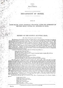 Bendigo Historical Society Inc.
Document - STRAUCH COLLECTION: DEPT OF MINES,REPORT ON HUNTLY ALLUVIAL LEAD
... maps. Document STRAUCH COLLECTION: DEPT OF MINES,REPORT ...BHS Collection1898 Victoria Department of Mines report on the Huntly Alluvial Lead with assorted maps.mining, extraction, alluvial -
 Bendigo Historical Society Inc.
Map - BENDIGO PARISH PLAN
BHS CollectionBendigo Parish Plan Section C Paper with edges bound with canvas tape.bendigo, land sales, parish map