Showing 245 items
matching bendigo gold fields.
-
 Bendigo Historical Society Inc.
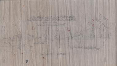
Map - STRUGNELL COLLECTION: BENDIGO GOLD FIELD GEOLOGICAL SURVEY, 1936
... STRUGNELL COLLECTION: BENDIGO GOLD FIELD GEOLOGICAL SURVEY... COLLECTION: BENDIGO GOLD FIELD GEOLOGICAL SURVEY ...BHS CollectionBendigo Goldfieds Geological Survey. Prepared in the Bendigo Office Bottom Section of original map.Dept of Mines Victoriabendigo, gold mining, geological map -
 Federation University Historical Collection
Map, Ballarat Goldfield, c1898
This map shows geological features, suggests the last basalt flow, and includes alotments and names of Mining Companies. Although this map has no date on it the Ballarat Industrial School is used for dating purposed. The Ballarat Industrial School ran from 1869-1879, but the term Ballarat Industrial School Reserve was still in use in 1898 and possibly beyond.Geological Map of Ballarat with 3 holes in the left hand side. The map indicates the position of Lake Wendouree, Township of Warrenheip, Ballarat East, Industrial School Reserve, Winters Swamp, Police Paddock, Wyndholm Premptive Right (Salton and Waldie), Black Hill, Vale Park Reserve, Pennyweight Hill, Little Bendigo, Black Swamp Lead, monte Christo Reef, Chinaman's Gully, Miners Rest, Pincotts Dam, Northumberland Gully. It also show the following goldmining companies: City of Ballarat, Kohinor, Hand and Band, Great North West, Northern Junction, Kneeshaw, Rossers Freehold, Silurial.ballarat, warrenheip, lake wendouree, ballarat east, winters swamp, winter swamp, wyndholm premptive right, cemetery, vale park reserve, little bendigo, kneeshaw co., industrial school reserve, kirks dam, pincotts dam, black hill, wombat hill, dead horse gully, miners rest, mt rowan, salton and waldie, rose hill co, great north west no 1, rose's freehold co, hand and band co, police reserve, police paddock, mount rowan, ballarat industrial school reserve, market reserve, winter's swamp, kneeshar co, monte cristo line of reef, chinaman's gully or black snake, milkmaid's gully, ballarat gold field, bakery hil lead, old gravel pits lead, golden point lead, eureka lead, miner's rest, yarrowee creek, leigh creek, black swamp lead, yorkshire reef, nil desperandum reef, cockatoo lead, hit or miss gully, herbert werner frederick de nully, pennyweight hill, esmond's lead, ash's lead, nightingale lead, john bull gully, gladstone reef, whitehorse reef, petticoat creek, pincott's dam, frenchman's gully, tim's crushing plant, jenkin's gully, california gully, drake's creek, sulton and waldie, ballarat undustrial school, ballarat & mariborough railway -
 Buda Historic Home & Garden Castlemaine
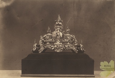
Photograph, c1858 - 1860
Gold and Redgum Inkstand made by Ernest Leviny, c1855-1858. Presented to Mr J.V.A. Bruce, contractor for the Melbourne and Murray Railway by the workmen, at Woodend on Monday 8th July 1861. This gold inkstand was Leviny's first major masterpiece commenced around 1855 and made from gold found on the Victorian fields. It featured four gold nuggets representing the Southern Cross from the goldfields of Ballarat, Bendigo Maryborough and Castlemaine. It was exhibited in Melbourne in 1858, and again in 1861 where it was awarded a 1st Class Certificate at the Victorian Exhibition in Melbourne. In 1862 it was exhibited at the London International Exhibition where it attracted a great deal of attention and was published in The Art Journal Illustrated Catalogue accompanying the exhibition. The whereabouts of the Inkstand is currently unknown.Matt, albumen print, mounted on lightweight card backing. Albumen photograph of a gold and redgum inkstand. Elaborate inkstand highly decorated with cast figures. Mounted on a redgum base.Stamp embossed on upper left corner. Crown in a circle with the words Bristol Paper. Handwritten in ink under image. "Gold inkstand presented at the opening of the Railway, designed by the late Ernest Leviny Esq. October 13th 1862. Made of almost pure gold and cost £700".inkstand, ornament, gold, goldsmithing, london exhibition 1862, melbourne and murray railway, photograph, woodend, 8 july 1861, mr j. v. a. bruce -
 Eltham District Historical Society Inc
Photograph - Digital Photograph, Marguerite Marshall, One Tree Hill Mine, Smiths Gully, 8 June 2006
Gold was discovered on One Tree Hill in 1854. The site has been worked intermittently until fairly recent times. Published: Nillumbik Now and Then / Marguerite Marshall 2008; photographs Alan King with Marguerite Marshall.; p53 Though still a working mine, One Tree Hill Mine at Smiths Gully, now stands in a tranquil reserve surrounded by bush and native animals - in contrast to its heyday. In the mid 19th century, when the mine was part of the Caledonia Goldfields, hundreds of men in search of their fortune worked the alluvial gold in the Yarra River, its tributaries and the reefs that made up the goldfields. Miner Stan Bone, assisted by Wilfred Haywood, is the last of the independent gold miners in the area and still uses the quartz crushing battery as miners did when gold was first discovered in the area in 1851.1 Stan, who is the last of six generations of miners in his family, was aged 17 when he began mining on his father Alex’ mine, The Golden Crown in Yarrambat. These days, after blasting the gold-bearing rock in Mystery Reef, one of the four reefs at One Tree Hill, Stan transports it around five kilometres by tip truck to the Black Cameron Mine for crushing. There he uses water from the waterlogged mine, (which still contains gold), as the Happy Valley Creek at One Tree Hill is usually dry.2 The One Tree Hill Mine has been worked for close to a century since it opened around the late 1850s.3 The Swedish Reef was its most productive reef and one of the largest in the area. Around 1859, extractions included 204 ounces (5.8kg) of gold, won from 57 pounds (26kg) of stone.4 Then during World War Two, Stan’s uncle, Bill Wallace, and Alex Bone, closed the mine. In 1973, Stan, with his Uncle Bill, reopened the Black Cameron Mine and worked there until 1988. Stan resumed mining One Tree Hill in 1998. As late as the 1920s gold was picked up by chance! When crossing a gully on his way to vote at the St Andrews Primary School, Bill Joyce picked up some quartz containing gold. This site was to become the Black Cameron Mine. The Caledonia Diggings, named after Scotland’s ancient name by local Scots, began around Market Square (now Smiths Gully) and included Queenstown (St Andrews), Kingstown (Panton Hill) and Diamond Creek. There were also poorer bearing fields in Kangaroo Ground and Swipers Gully (now Research). * None of these compared in riches to the Ballarat and Bendigo fields5, but the Caledonia Diggings continued intermittently for close to 100 years. Gold was discovered in Victoria following a bid to stem the disappearance of much needed workmen to the New South Wales diggings. Several businessmen offered a reward of £200, for the discovery of gold within 200 miles (322 km) of Melbourne. Late in June 1851, gold was first discovered at Andersons Creek, Warrandyte. Then in 1854, George Boston and two other men discovered gold at Smiths Gully. Gold transformed the quiet districts, with a constant flow of families and vehicles on the dirt tracks en route to the Caledonia Diggings. Three thousand people worked the gullies in Market Square, including about 1000 Chinese miners. The square established its own police, mining warden, gold battery, school, shops and cemetery and grog flowed. Market Square flourished until the middle 1860s. Bullocks transported quartz from the Caledonia Goldfields to the crushing machinery at the Queenstown/St Andrews Battery, near Smiths Gully Cemetery. It was destroyed by bushfire in 1962. By the late 1850s, most early alluvial fields were in decline, but minor rushes continued until around 1900 and some until the early 1940s. Some miners did well, although most earned little from their hard labour in the harsh and primitive conditions.6 But according to historian, Mick Woiwod, the gold fields helped to democratise society, as individuals from all walks of life were forced to share experiences, and the ability to succeed, depended less on inherited wealth or social rank.This collection of almost 130 photos about places and people within the Shire of Nillumbik, an urban and rural municipality in Melbourne's north, contributes to an understanding of the history of the Shire. Published in 2008 immediately prior to the Black Saturday bushfires of February 7, 2009, it documents sites that were impacted, and in some cases destroyed by the fires. It includes photographs taken especially for the publication, creating a unique time capsule representing the Shire in the early 21st century. It remains the most recent comprehenesive publication devoted to the Shire's history connecting local residents to the past. nillumbik now and then (marshall-king) collection, gold mining, one tree hill mine, smiths gully -
 Bendigo Historical Society Inc.
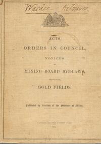
Book - AUSTIN COLLECTION: MINING BOARD BYE-LAWS
BHS CollectionBook, hard bound. Buff colour covers, dark brown print. Acts, Orders in Council, notices and Mining Board Bye-laws relating to the Gold Fields, published by direction of the Minister of Mines. 1874. Warden Kilmore written in pen and ink at top.bendigo, mining, mining board bye-laws -
 Bendigo Historical Society Inc.
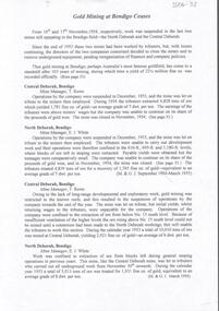
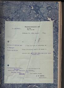
Document - MARKS COLLECTION: MINING LEASE BLOCKS 1873
Plan mining lease blocks 1873, timber hanger on top two brass rings, securing tape, round timber holder on bottom, scroll. On top Schedule of Mining Lease Blocks shown on the plan of the Sandhurst Gold Field, Published May 1873' Names of mining Companies listed with identifying number and area of mine site. E.g. '447 Johnson's Reef Gold Mines 7a, 2r, 8 p (acres, roods, perches). Number linked to the mine site shown on Sandhurst Gold Field map.bendigo, mining, mining lease blocks 1873 -
Bendigo Historical Society Inc.
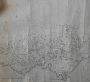
Map - STRUGNALL COLLECTION: BENDIGO GOLD FIELD GEOLOGICAL SURVEY, 1936
... STRUGNALL COLLECTION: BENDIGO GOLD FIELD GEOLOGICAL SURVEY... STRUGNALL COLLECTION: BENDIGO GOLD FIELD GEOLOGICAL SURVEY ...BHS CollectionBendigo Goldfieds Geological Survey. Prepared in the Bendigo Office Lower Section of original map. Note with map says other items donated - yet to be catalogued. TO BE FOUNDDept of Mines Victoriabendigo, gold mining, geological map -
Bendigo Historical Society Inc.
Map - STRUGNELL COLLECTION: BENDIGO GOLD FIELD GEOLOGICAL SURVEY, 1936
... STRUGNELL COLLECTION: BENDIGO GOLD FIELD GEOLOGICAL SURVEY... COLLECTION: BENDIGO GOLD FIELD GEOLOGICAL SURVEY ...BHS CollectionBendigo Goldfieds Geological Survey. Prepared in the Bendigo Office Top Section of original map.Dept of Mines Victoriabendigo, gold mining, geological map -
 Bendigo Historical Society Inc.
Document - CENTRAL DEBORAH GOLD MINE GOLD MINING AT BENDIGO CEASES
BHS CollectionTyped A4 document which describes the closing on November 16th and 17th 1954, of the last two mines still operating in the Bendigo field - the North Deborah and the Central Deborah.bendigo, mining, central deborah gold mine, central deborah gold mine -
 Bendigo Historical Society Inc.
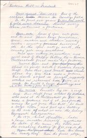
Administrative record - South New Chum Syncline Gold Mines N.L. Minute Book, 1932 - 1940
South New Chum Syncline South New Chum Syncline Gold Mines, N.L., has been floated with a capital of £27,500 in 55,000 shares of 10/ each. Forty thousand have been issued at 1/,10,000 fully paid shares go to vendors, and 5000 will be held in reserve. - Messrs. Savage and Nicholas report that the issue was heavily over-subscribed. The property is situated in the central portion of the Bendigo field, adjoining such former producers as the Victoria Quartz. Lansell’s Big 180, North Old Chum and New Chum. (Bendigo Advertiser, 29th September 1932).Green hard cover book, maroon binding on spine, 284 pages of which 94 are used. 'Minute Book' on front cover. Written in pencil across top of name ' South New Chum Syncline'. Inside front cover affixed to page, document 'Registrar-General re Notice of Office and of Manager, filed 23.10.32 in connection with South New Chum Syncline Gold Mines N.L. Minutes in book date from 5th October 1932 to 23rd August 1935. First minutes of meeting describes the Company as having 55,000 shares of ten shillings each. Final two pages have documents affixed that relate to the closure and sell-off of the free-hold property and mine equipment in 'Happy Valley Road, Bendigo for the sum of not less than Two Hundred and fifty pounds and that out of the proceeds thereof the following amounts be paid', An amount of 120 pounds, thirteen shillings and two pence are listed. Minute Book is part of the Margaret Roberts Collection. bendigo, gold mining, south new chum syncline gold mine, j.j. stanistreet, legal manager, margaret roberts collection, -
 Bendigo Historical Society Inc.
Document - REPORT FROM THE SELECT COMMITTEE UPON THE CLAIMS OF HENRY FRENCHAM, 1890
... to locate gold in the Bendigo field. Members of the Committee were... in relation to who was the first person to locate gold in the Bendigo ...( x ref 5673 , 8235 , Box 83 , 9077 ) Reports from the Gold Enquiry Select Committee from September 4th 1890 - 23rd October, including a list of witnesses, Minutes of Evidence 11th September 1890, 18th September 1890 and 25th September 1890; also, Appendices A - T, and also a location map drawn from memory by W. (William) Sandbach 18th Sep 1890 and Lithographed at the Department of Lands and Survey Melbourne by S. B. Bonney 28th October 1890. This enquiry covers the opinions of Robert Atkinson, Henry Frencham and Robert Francis Walker in relation to who was the first person to locate gold in the Bendigo field. Members of the Committee were Mr Bailes, in the chair, Mr Burrowes, Mr Cameron, Mr A, Young, Mr Gordon, and Mr Foster. Other name at the enquiry were, David Dunlop, John Paton, William Steward, Christian Asquith, James Graham, Ben. Bannister, Mr Fenton, T. J. Rossiter, P. P. Farrell, Thomas Robinson. Other persons who had made claims were; Patrick Peter Farrell, Frederich Fenton, Mrs. Margaret Kennedy, William Henry Johnson, Edward Pepperell, Henry Byass, William Sandbach, William Steward, Mrs John Barnett, widow of Christian Asquith's son, Robert Francis Walker, David Dunlop, John Paton.gold enquiry, henry frencham, gold discovery, david dunlop, john paton, william steward, christian asquith, james graham, ben. bannister, mr fenton, t. j. rossiter, p. p. farrell, patrick peter farrell, frederich fenton, mrs. margaret kennedy, william henry johnson, edward pepperell, henry byass, william sandbach, mrs john barnett, thomas robinson -
 Bendigo Military Museum
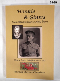
Book - BOOK WW1, Brenda Stevens - Chambers, Honkie & Ginny, 2013
... Front and the gold fields of Bendigo. A personal tale from... Front and the gold fields of Bendigo. A personal tale from ...Honkie & Ginny is a journey that travels from the cottagers of Port Melbourne to Gallipoli, the battle fields of the Western Front and the gold fields of Bendigo. A personal tale from a grand niece.Title: Honkie & Ginny From Black Sheep to Holy Dove, Henry Foster Midgley 1894 - 1917 At Peace in Flanders. Biography. Soft cardboard cover, black print on front, spine & back. 2 sepia portraits, smaller one of a woman superimposed over the left corner of a soldier in uniform, yellow coloured background. Below portraits is a small colour photo of At Peace in Flanders with poppies below these words Back cover has colour photos of a wreath. 220 pages, cut plain paper. Illustrated in black & white are photos, line drawings, posters & paintings.books-biography, military history -
 Bendigo Historical Society Inc.
Photograph - SOUTH NEW MOON MINE - EAGLEHAWK, 1935
2 Photographs on a folded board. One black and white, one sepia. Both photographs of South New Moon Mine, Eaglehawk, taken from 2 different views. Written on board around the photos. Gold yield 257.498 ozs. Dividends $ 1.106.560.00. Leading mine on field 1901-05. Leading mine in state 1903. Operated 1871 to 1920's. Revived 1933 to 1941. The sepia photo on right side of cardboard says, 'Above photo taken 1935.' Written on back of one photo, A.Richardson, 29 Harrison Street, Bendigo.'eaglehawk, mine - south new moon., olive pell collection. south new moon mine -
 Bendigo Historical Society Inc.
Map - MAP: VICTORIA MINING DISTRICTS, MINING DIVISIONS AND THE GOLD FIELDS, 1866
Map: printed map stuck on backing paper (waxed?) to support material. Shows mining districts, divisions and goldfields of Victoria. Printed in blue ink on bottom ' this map compiled in 1866. Printed in 1869.' Printed on bottom ' engraved by William Slight under the direction of R. Brough Smyth FGS Lon., the Hon John Macgregor MLA Minister of Mines, published 24th. October 1866. Revised and corrected by Arthur Everitt, January 25th. 1869. On back of map ' this map was compiled by the Mines Department of Victoria 24th. October 1866, corrected by Arthur Everett 15th. January 1869. Presented to the Bendigo Historical Society by E. Hayward 1st. December 1950.victoria, bendigo, goldfields, gold reefs, mining divisions, map -
 Bendigo Historical Society Inc.
Document - LUCY HILL COLLECTION: BENDIGO MINING FIELD, 1860-1951 approx
Articles by Lucy Hill: Articles about the reefs and whims around Bendigodocument, gold, mining in bendigo, lucy hill collection - from the manuscript of the late lucy hill and published in the bendigo advertiser - compiled by john hattam -
 Federation University Historical Collection
Map, Ballaarat Gold Field, 1861, 1861
A party of surveyors camped by Yuille's Swamp (later Lake Wendouree) and surveyed the countryside for a map to be produced by the Geological Survey of Victoria. In November 2004 the Central Highlands Regional Library presented a special edition of 200 copies of the 1861 map reproduced from a copy in their collection. Original 1861 map of Ballarat showing streets and leads. Blue dots indicate gold leads, and red lines indicate auriferous quartz reef and outcrops of quartz veins."Compiled & Drawn from the Survey of Mining Surveyors Davidson, Fitzpatrick and Cowan & the Plans in the Surveyor General's Office by J. Brahe, 21st October 1861. R. Brough Smyth, Secretary for Mines. The Honourable J.B. Humffray, M.L.A. Commr of Mines.”ballarat, map, ballarat east, lake wendouree, survey, mines, robert davidson, ballarat gold field 1861, yuille's swamp, wendouree swamp, little bendigo diggings, gold leads, old post office hill, specimen hill, bakery hill, black hill, dead horse creek, brown hill, pennyweight hill, clayton hill, soldiers hill, golden point, gum tree flat, white flat, poverty hill, chinese village, robert brough smyth, ballarat map 1861, ballaarat vineyard, dead horse gully, deadhorse creek, invermay, black hill flat, gaelic church, police reserve, magpie range, dalton's flat, caadian lead, rifle butts, powder magazine, bathing house, government camp, gold office, chinese, llanberrris, victoria theatre, charlie napier hotel, united states hotel, grape's hoel, clayton's hill, cattleyard hill, free trade hotel, esmond lead, bakery hill, black hill lead, juvenile reformatory, ballarat orphanage, lady barkly lead, triffet's slaughter yard, little bendigo, melbourne road, t. cowan, thomas cowan -
Clunes Museum
Book, CAMBRIDGE PRESS et al, GREATER THAN GOLD, 1985
A HISTORY OF AGRICULTURE IN THE BENDIGO DISTRICT FROM 1835 TO 1985COVER HAS GREEN BACK GROUND WITH GHOSTED POPPET HEAD IMAGE BEHIND A FULL COLOUR IMAGE OF A MECHANICAL HARVESTER IN A FIELD OF GRAINnon-fictionA HISTORY OF AGRICULTURE IN THE BENDIGO DISTRICT FROM 1835 TO 1985history of agriculture, historical field days committee -
 Bendigo Historical Society Inc.
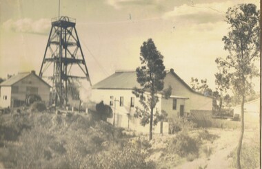
Document - MCCOLL, RANKIN AND STANISTREET COLLECTION: THE SEDGWICK GOLD MINE, 1930's
Manilla Folder containing documents relating to the Sedgwick Gold Mine, formerly the Great Eastern. Including plan of area applied for lease No. 10414 by E. Peel. Comprehensive hand written description of mine from R. M. Williams. And record taken from the Bendigo office by J. Caldwell, Field GeologistMcColl Rankin & Stanistreetgold mining, miners' safety cage, sedgwick, gold mine, sedgwick, great eastern, geology -
 Bendigo Historical Society Inc.
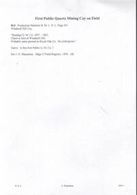
Document - WINDMILL HILL - FIRST PUBLIC QUARTZ MINING COY ON FIELD
First Public Quartz Mining Coy on Field. Ref: Production Statistics B. M. L. N. L. Page 201 Windmill Hill Coy. 'Bendigo Q. M. Co,1857 - 1863. Claim at foot of Windmill Hill. Probably same ground as Royal Oak Co. No yield given.' Query. - Is this first Public Q. M. Co.? See J. N. Macartney. Bdgo G'Field Registry 1870. Initialled AR. Document from Albert Richardson Collection of mining history.document, gold, windmill hill, windmill hill, first public quartz mining coy on field, production statistics b m l n l page 201, windmill hill coy, bendigo q m c 1857 - 1863, royal oak co, j n macartney bdgo g'field registry 1870 -
 Bendigo Historical Society Inc.
Document - RESEARCH PAPERS: THE INIMITABLE CHARLES THATCHER, 2002
Charles Robert Thatcher (1831-1878) trained in England as a flautist before travelling to the Bendigo goldfields in 1853. He was unsuited and unsuccessful as a miner so decided to rely on his music to make his fortune. He was considered a 'comic vocalist' who wrote many songs about the observations he made on the goldfields. These songs were often satirical and were published in newspapers as poems. He travelled extensively around the Victorian goldfields and also toured New Zealand. In 1861 he married widowed singer Anna Vitellie who performed with him, singing sentimental ballads. In 1870 the family returned to England where Charles became an importer of curios, following in his father's footsteps. He travelled to China, Japan and India sourcing stock for his business and on one such trip he contracted cholera and died in Shanghai. His wife returned to Australia and taught singing in Moonee Ponds.A talk written by Jim Evans for the Bendigo Historical Society in September 2002 regarding the gold field entertainer Charles Robert Thatcher and his many chaotic adventures and performances across Bendigo and Australia. -
 Bendigo Historical Society Inc.
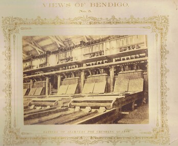
Photograph - VIEWS OF BENDIGO: BATTERY OF STAMPERS, c. 1870's
... Fields of Bendigo. The most extensive Plants, being those... by means of Stampers, adopted on the Gold Fields of Bendigo ...BHS CollectionSepia toned photograph. Photograph No. 5 - Battery of Stampers for crushing quartz. Printed on front of mount - 'The reduction of Quartz by means of Stampers, adopted on the Gold Fields of Bendigo. The most extensive Plants, being those at Koch's Pioneer Claim, Long Gully; The Great Extended Hustler's; also the Garden Gully United; and the Crushing Plant, New Chum Gully. Nicholas CaireN.J. Cairetopic, mining, battery -
 Federation University Historical Collection
Map, Ballaarat Gold Field, 1861, 21/10/1861
A party of surveyors camped by Yuille's Swamp (later Lake Wendouree) and surveyed the countryside for a map to be produced by the Geological Survey of Victoria. In November 2004 the Central Highlands Regional Library presented a special edition of 200 copies of the 1861 map reproduced from a copy in their collection. Original geological map of Ballarat showing property, waterways, mines, churches, schools, water races, and garden reserves. It was compiled and drawn from the surveys of Mining Surveyors Davidson, Fitzpatrick and Cowan.Compiled & Drawn from the Survey of Mining Surveyors Davidson, Fitzpatrick and Cowan & the Plans in the Surveyor General's Office by J. Brahe, 21st October 1861. R. Brough Smyth, Secretary for Mines. The Honourable J.B. Humffray, M.L.A. Commr of Mines.ballarat, map, davidson, robert brough-smyth, fitzpatrick, cowan, yuille's swamp, public garden reserve, manure depot, black hill, ballarat east, old post office hill, pennyweight hill, claytons hill, golden point, mining, railway, cricket ground, swamp creek, cemetery, sludge reserve, bakery hill, gaelic church, juvenile reformatory, orphanage, specimen hill, eureka lead, cattle yard hill, dalton's flat, chinese village, poverty hill, railway reserve, little bendigo diggings, pound reserve, allied armies, flour mill, agricultural reserve, marsh, survey reserve, survey corps, white flat, yarrowee, yarrowee creek, brache, j. brache, survey, ballaarat gold field 1861 -
 Bendigo Historical Society Inc.
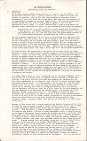
Map - RED WHITE & BLUE EXTENDED - PLAN OF RED WHITE AND BLUE EXTENDED MINE TRANSVERSE SECTION
Transverse section of the Red White & Blue Extended Mine on the Sheepshead Line of Reef showing shafts, depths and geological features. Drawn on tracing film in pencil. Signed by J J Caldwell, District Field Geologist, Mines Department, Bendigo and dated 5/12/1940. Notes prepared by Albert Richardson.document, gold, red white & blue extended, red white & blue extended, plan of red white & blue extended mine transverse section, j j caldwell, mines dept bendigo -
 Bendigo Historical Society Inc.
Document - VICTORIA HILL - THE BENDIGO DIGGINGS, PRELIMINARY DRAFT FOR BROCHURE
BHS CollectionNine typed pages of notes on a preliminary draft for a brochure on the Bendigo Diggings. First part is the objective which is to preserve the mining history and to have exhibits in the places they were used, e.g. quartz mining machinery exhibited in a quartz mining area, not on an alluvial field. Part B is historical notes on the area. Part C is the Site - Victoria Hill area. Part D is Stage One which consists of carpark area, technological museum, restaurant, mineral haulage line, picnic ground, earthworks and planting over the area. Part E is Stage Two which will consist of the open-air exhibits, in the area surrounded by the mineral haulage line, and the Central Nell Gwynne mine on the west side of the site. Part F is Stage Three which will consist of the winery, the steam tram track, the lake, the wildlife sanctuary and various buildings associated with gold mining. Part G is Costing with the prices to be filled in. Parts H and I are the Appeal and the Committee. Details to be filled in. Notes prepared by Albert Richardson.mining, marketing, victoria hill, victoria hill, the bendigo diggings - preliminary draft for brochure, aust national travel association, tullamarine jetport, emu bottom homestead, kyneton historical museum, chinese joss house, eaglehawk museum, whipstick scrub, cairn curran reservoir, castelmaine historical museum and market hall, national trust, ballarat hiatorical park, echuca's hopwood gardens, swan hill folk museum, gibson's mount alexander no 2 squatting run, captain brown, chief commissioner wright, hustler's reef, thomas hustler, mining board, drainage of reefs act 1862, first world war, bendigo amalgamated goldfields, second world war, sandhurst, w c vahland, battery trams, horse trams, steam trams, electric trams, central nell gwynne mine, theodore ballerstadt, george lansell, new chum hill, ballerstadt's open cut, 180 mine, new chum syncline battery, william rae, victoria quartz, wittscheibe's 'jeweller's shop', luffsman and sterry, gold mines hotel, adventure, bendigo and district tourist association, bendigo city council, bendigo branch of the royal historical society of victoria, professor brian lewis, school of architecture and building at the university of melbourne, taylor horsfield, lord robert cecil, south australian gold commissioner -
 Bendigo Historical Society Inc.
Document - VICTORIA HILL - SPECIAL FEATURES
Four hand written pages and typed copy, titled The Victoria Hill - Special Features. Notes mention the Victoria Hill, the deepest workings on the field,the first mine on the field to 2,000 and 3,000 feet in depth, Ballerstedt's Open-Cut, Rae;s Open-Cut, Wittscheibe's Jeweller's Shop, the Adventure, the richest cross-section of the whole of the Bendigo Goldfield, the first mine to pay dividends from ore mined below 1,000 feet to 1,500 feet from the surface, the tallest poppet legs on the field, Lazarus Mine, Barnet Lazarus, Mt Alvernia Hospital, Central Red White & Blue. Notes prepared by Albert Richardson.document, gold, victoria hill, victoria hill, victoria hill - special features, john neill macartney, the argus, the australasian, bendigo goldfields registry, victoria reef quartz mine, the deepest workings on the field, the first mine on the field to reach 2, 000 and 3, 000 feet in depth, lansell's 'big 180' mine, hot water, george lansell, theodore ballerstedt, fortuna, ballerstedt's open-cut, rae's open-cut, wittscheibe's jeweller's shop, adventure, advance, cinderella, the private pioneer coy, new chum & victoria mine, a h q survey regiment, tallest poppet legs, lazarus mine, barnet lazarus, mt alvernia hospital, central redwhite and blue, hudson's, burrowes & sterry, b c v 8 television station, swan hill's channel 11 -
 Bendigo Historical Society Inc.
Book - MINING REPORTS - THE CONFIDENCE GROUP OF MINES BULLETIN NO 41
Light brown covered booklet 'Bulletins of the Geological Survey of Victoria issued by W Dickson, Secretary for Mines, Under the Authority of the Hon. S Barnes M L A Minister of Mines. No 41 The Confidence Group of Mines, Bendigo with Plans and Sections by H S Whitelaw, Field Geologist, dated 1918. Mines mentioned are: Confidence Extended Mine, Confidence Tribute Company and the Central Windmill Hill Mine. Mentioned in the report are crushings and gold yield, details of levels, names of leases along the reef. Extracts from Mine Manager's Half-yearly Reports, 1878-1915 of tons crushed and gold yield. Plans and sections of the Confidence Extended Mine on the Garden Gully Line of Reefs are: Plate I General Plan of All Levels, Plans of Levels Plate No II, Plans of Levels Plate No III, Transverse Section Plate No IV, Longitudinal Section Plate No V, and Central Windmill Hill Mine Transverse Section Plate No VI. Plates signed by H S Whitelaw 17 & 18/6/16 and 20/7/16. Booklet if part of the Albert Richardson Collection. book, bendigo, mining reports, mining reports, the confidence group of mines bulletin no 41, confidence extended mine, confidence tribute company, central windmill hill mine, department of mines, bulletins of the geological survey of victoria, w dickson, the hon s barnes, h s whitelaw, h j green, mr robert eddy, mr w h cundy, j foster, c j thompson -
 Bendigo Historical Society Inc.
Document - MINING REPORTS - REPORT OF, ON AURIFEROUS DRIFTS AND QUARTZ REEFS
Printed document: Geological Department: Report of, on auriferous Drifts and Quartz Reefs, dated 8th May,1866. Paper describes the gravels and rocks of a Geological Survey. Survey is compared with the lower drifts of Bendigo, Epsom, Ballaarat, Castlemaine and other gold-fields. Four colour sketch-sections included. Document is part of the Albert Richardson Collection. gold, mining reports, mining reports, report of, on auriferous drifts and quartz reefs, mr bindon, alfred r c selwyn, john ferres -
 Bendigo Historical Society Inc.
Document - MINING REPORTS - GEOLOGICAL REPORT OF MAIN SECTION OF GOLDFIELD
Handwritten notes by Albert Richardson, with typed copy, on a Geological report of main section in a length of 5 miles. Report mentions sandstones and slates, with occasional calcareous bands, which show a cyclic arrangement. Also mentioned are different zones of sediments, anticlines, structure of the field and references: Page 1028 Formation of Bendigo Quartz Reefs by F R Stilwell to 1032 and pages 160 to 163 'Ore deposits as Related to Structural Features - A H Newhouse. document, gold, mining reports, mining reports, geological report of main section of goldfield, the bendigo goldfields page 1015, formation of bendigo quartz reefs by f r stilwell page 1028 to 1032, ore deposits as related to structural features pages 160 to 163 a h newhouse -
 Bendigo Historical Society Inc.
Document - ALBERT RICHARDSON COLLECTION: VICTORIA HILL IRONBARK
Three page document hand written by Albert Richardson, on the history of Victoria Hill, Ironbark. 'one of the richest areas on Bendigo field. In the first six years, £1,200,000 worth of gold was obtained. Almost every claim returned a fortune.' Page three title: Other features on Victoria Hill. 'Adjacent to Central Nell Gwynne area as the mining museum. Adjacent to the New Chum Hill on direct south side of the Calder Highway. This hill reached by a short and excellent access road gives a magnificent view of Bendigo and Golden Square, and a very good view of another tourist attraction, Lansells 'Fortuna' now Survey Regiment's headquarters. This hill is the centre of another rich area. The Lazarus mine 3,360 feet deep with 24 saddle reefs in 2,200 feet. The New Chum United, Lansell's 222with its 120 ft high poppet legs. BCV 8, John Brown Knitwear factory, Esposito's Gold Mines Hotel, Central Nell Gwynne and Manchester tram loops are mentioned.Albert Richardsonbendigo, mining, victoria hill -
 Bendigo Historical Society Inc.
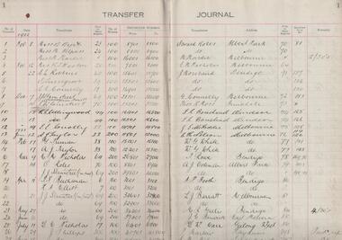
Administrative record - South New Chum Syncline Gold Mines Share Transfer Journal, 1934 to 1939
South New Chum Syncline (The Sun News-Pictorial (Melbourne, Vic. : 1922 - 1954; 1956) Thu 29 Sep 1932 ) Page 21: 'South New Chum Syncline Gold Mines,N.L., has been floated with a capital of £27,500 in 55,000 shares of 10/ each. Forty thousand have been issued at 1/, 10,000 fully paid shares go to vendors ,and 5000 will be held in reserve. -Messrs. Savage and Nicholas report that the issue was heavily over-subscribed. The property is situated in the central portion of the Bendigo field, adjoining such former producers as the Victoria Quartz. Lansell’s Big 180, North Old Chum and New Chum'.Black cover, red spine, fifty page journal. Written on front cover in black text on white background 'Transfer Journal' Purple stamp above 'Transfer Journal' 'South New Chum Syncline Gold Mines' . Entries detail the transferror, page in share register, number of shares, distinctive numbers, transferee, address, folio in share register, cancelled script number and remarks. Entries date from November 3rd. 1932 to June 27th 1939. Journal is part of the Margaret Roberts Collection. bendigo, gold mining, shareholders, share transfers, south new chum syncline gold mines, new chum line of reef