Showing 229 items matching " east boundary"
-
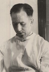
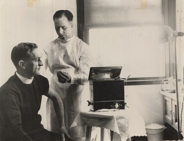 St Patrick's Old Collegians Association (SPOCA)
Photograph - Teachers, Jesuits
-
 St Patrick's Old Collegians Association (SPOCA)
Photograph - SPOCA, Patricians FC
-
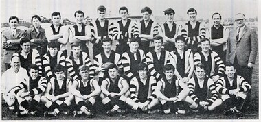
 St Patrick's Old Collegians Association (SPOCA)
Photograph - SPOCA, Patricians FC
-
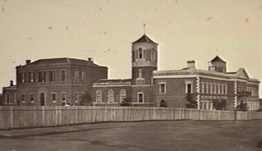 St Patrick's Old Collegians Association (SPOCA)
Photograph - Buildings, SPJC, Exterior, 1850s Image
-
 City of Kingston
Photograph - Black and white, c.1930
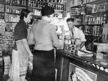
... located on the corner of Centre and East Boundary Roads, East ...This photograph shows Judd's Grocery Shop located at 224 Charman Road, Cheltenham in the 1930's. Alan Hutchins is the shop attendant, serving two patrons; Merle Judd (left) and Marion Elliott (right). Judd's Grocery Shop was opened by Clarence Judd in the 1920's and was a successor to the family's business formerly located on the corner of Centre and East Boundary Roads, East Bentleigh. Cheltenham had become an established village during the 1920's and Charman Road represented a second, more commercial development in the area. Black and white photograph of a grocery shop interior displaying a variety of items for sale. A male stands behind a counter, looking at the camera. Two females stand in front of the counter facing the male. One female is wearing a hat. Handwritten in blue ink: 181 Handwritten in red ink: 72%shopping, strip shopping, cheltenham, charman rd, grocery -
 City of Kingston
Photograph - Black and white, c. 1920
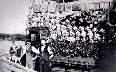
... -roomed house in East Boundary Road, in the area then called East ...Market gardening was an integral part of the development of the area now known as Kingston. In this image there are two men standing beside a truck loaded with vegetables. Painted on the truck are the words South Rd, A & H Marriott, indicating these men are from the Marriott family. The truck appears to be a Republic Commercial Car by Republic Motor Truck Co, Michigan, c. 1916.The Marriott family arrived in Port Phillip in 1857. It wasn't until 1876 that the family purchased 30 acres with a four-roomed house in East Boundary Road, in the area then called East Brighton.Black and white image of two men standing in front of a truck fully loaded with vegetables intended for market. There are also two children standing in front of the truck.Handwritten in black ink on a round red sticker on the reverse: X18 Handwritten in red ink on reverse: 35% -
 Glen Eira Historical Society
Book - Ormond Amateur Football Club
This file contains two items: 1/A 50 page book on history of Ormond Junior Football Club, from its days as St. Annes Football Club to its amalgamation with Ormond Amateur Football. Book compiled by Claire Barton from AGM meetings 2009. 2/A copy of six football club addresses from the city of Moorabbin Community Directory 1987.ormond junior football club, stock jack, stevens harold r., st. annes church hall, halls, maylan street, east bentleigh, bentleigh mckinnon youth club, clubs and associations, smith brian, scott r. ken, steve stevens, keane adrian, oaten max, dight john, southam david, patterson don, stait ron, ceresa jack, forward cyril, moorehouse bob, forward may, heggert joan, morris jill, brabner martene, williams margaret, jackson judy, mcinery loris, mckinnon high school, walnut street, bailey reserve, boundary road, dowling russell, miller ian, keane david, starke neil “speedie.”, red cross, schweppes, sponsors, claremont junior football club, glenorchy football club, hudson peter, heggert keith, hilton ken, ormond blues, barassi ron, dargavel marita, beggs mr., smith mr., kaighal mr., gunn e. e., morcum glen, cochrane b., clark d., tate geoff, dargavel b., pappas sid, melbourne football club, brabner cameron, siderellis terry, morris wayne, burns robbie, kemp malcolm, siderellis tim, tinsley warwick, grant tom, middleton mick, dowling ian, clarke grant, young morgan, dawes bernie, dawes gerry, montgomery peter, peebles gordon, bentleigh bulldogs football club, mckinnon reserve, sheehy marnie, doble john, kerford phil, gleeson ian, rollasom brian, beynon wayne, societal events and activities, sheehy fay, wood ron, mckinnon butchers, brabner graham, begg john, moorabbin ufa, melbourne football club little league, interleague football matches, brandella cup, mccarthy justin, lough chris, montgomery stephen, carey tim, roe anthony, hardy chris, mccarthy justin, thomas matthew, perry richard, birch david, king denise, sparrow family, wilson ron, dupe stephen, karrageorgiov chris, hardy chris, borrett john, edgells darren, sparrow peter, ormond amateur football club, duncan john, beard j., warren e., pearson martin, waldron gary, marwood shane, collingwood vfl, jackson ricky, melbourne vfl, smith terry, richmond vfl, perkin phil, bentleigh juniors, beham m., neville david, taylor stephen, palmer tony, o’hara matt, ‘the cedric keane perpetual trophy’, st. anne’s football club, ormond east, valkstone, glenhuntly, st. patricks, primary schools, st. kilda junior leagues, lightening premiership, measures paul, msjfl u15 best and fairest, birch david, eishold lewis, eishold rohan, murrumbeena j. f. club, vic kick clinic, lough david, pennacchia luigi, best and fairest, buckley mark, rombotis john, d’astoli michael, msjfl team, king geoff, stumbles roger, williams cameron, byron noel, gillot heather, lehner elaine, oakleigh districts, stevens h. r., forward c. c., beggs j. w., scott k. k., kaighan t. a., dargavel m. mrs., forward n. c., keane m. j. mrs., woodhouse r. j. (dec), smith b. w., keane c. b., morgom g. m. (dec), dowling r. a., starke n., montgomery p., pearson p., kerford p., king d. mrs., lough d., perkin p., lehner e. mrs., russell r., interleague team, byron jason, guzzo anthony, kinsella trent, pym dominic, turner davis, b. f., artz ben, ralogaivav joe, jones alan, martin rick, editor, barton claire, australian rules football, sporting clubs, ormond, mckinnon, bentleigh, sports officials, committees of management, murrumbeena -
 Whitehorse Historical Society Inc.
Article - The Bulletin newsletter, The Bulletin Jun - Aug 2022, Our Burwood Village, June 2022
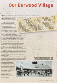
... Boundary Road Burwood East.../1858 Ballyshanassy Albers Ernest Boundary Road Burwood East ...An article about the first settlement surveyed in 1858 in the Burwood area known as Ballyshanassy. It later became Norwood and finally Burwood in 1879.An article about the first settlement surveyed in 1858 in the Burwood area known as Ballyshanassy. It later became Norwood and finally Burwood in 1879.An article about the first settlement surveyed in 1858 in the Burwood area known as Ballyshanassy. It later became Norwood and finally Burwood in 1879.ballyshanassy, albers ernest, boundary road burwood east, dempsey -
 Buninyong & District Historical Society
Photograph - Colour photograph, Colour photograph of the rear Yendon Primary School 1994 featuring the playground area and mural
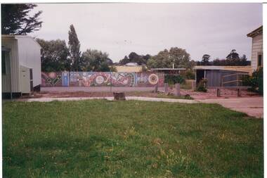
Yendon Primary School operated as a State School from 1877 and ceased operating in 1993. The School initially operated as the Buninyong East Common School from 1864.The children of railway workers from the Ballarat- Geelong railway would have formed much of the opening enrolment of the school.Colour photograph showing the rear of the former of Yendon Primary featuring the playground and mural on the boundary fence.Yendon Primary School 1994education, yendon, state schools -
MYLI My Community Library
Map - Nar Nar Goon County of Mornington Map, 1944, H.E Daw - Government Printer, June 1944
This was a map made in the period before Cardinia shire was created in 1994. With intricate labelling of lot allocations, this map is a invaluable research potential for understanding the settlement of the area and its development in the first half of the 1900s. A paper map with yellow shaded areas and black ink.On Left Side: Pakenham (lot numbers throughout the map) Top side: Gembrook, Tonimbuk Right Side: Bunyip, Koo-wee-rup East Bottom Side: By Authority: / H.E. Daw Government Printer / Melbourne Koo-wee-rup Bottom Right Corner: NOTE: The allotments colored brown are freehold. In respect of which the name. The Area, and the Date where given, are the particulars set out in the Crown grant as issued by the Lands Department. / After the issue of the Crown Grant, all subsequent dealings are effected at the office of titles, Queen Street, Melbourne, and particulars as to present registered ownership, boundaries, subdivisions, etc., may be obtained by search at that office. / This plan has been compiled from the Lands Department Record as at June 1944 / Nar-Nar-Goon / County of Mornington / Drawn and reproduced at the department of lands and survey, Melbourne Price 2/. June 1944 h.e. daw, map, nar-nar-goon, county of mornington, pakenham, koo-wee-rup -
 Warrnambool and District Historical Society Inc.
Document - Warrnambool City Council Preliminary Report Industrial Estate West Warrnambool, E Johnson, 9 March 1973
This preliminary report relates to 32½ acres of council owned land in West Warrnambool bounded on the North by McMeekin Road, on the East by Scott Street, on the South by Evans Street and on the West by the rear boundaries of properties facing Landmann and Granter Streets. In 2010, West Warrnambool was the largest of Warrnambool’s existing industrial areas, comprising approximately 109ha of industrial zoned land, the majority of which (101ha) is zoned IN1Z, with the remainder zoned INZ3. The area comprises a mixture of lot sizes supporting a diverse mix of industries. Larger parcels are occupied by the abattoirs, scrap metal industries, freight, the Council Depot and storage. Smaller lots are occupied by smaller manufacturers and wholesalers and service industries. [Ref: Warrnambool Industrial Land Use Review. Mesh Pty Ltd July 2010]This document is a preliminary report prepared by the Warrnambool City Council Engineer in March 1973 and provides an example of the planning process undertaken to develop one of Warrnambool's industrial areas. It contains details and costings of the proposed subdivision. Two foolscaps size pages of typewritten information. A detailed topographical map of the area with areas highlighted in blue, red, green, blue and purple pen.warrnambool city council, west warrnambool, industrial estate -
 Eltham District Historical Society Inc
Photograph - Digital Photograph, Alan King, Nillumbik Shire Offices, Greensborough, 30 March 2008
Nillumbik Shire Council transferred to the former Diamond Valley Shire Offices in Greensborough after municipal restructuing. The offices became the official Nillumbik Shire Council Offices on 16 October 1995. The former Shire of Diamond Valley Civic Centre or Shire Office building was officially opened on 26th February 1972. Archtiects were A.K. Lines, McFarlane & Marshall and it was built by L.U. Simon Pty Ltd, The Diamond Valley Shire had been created in 1964 from part of the City of Heidelberg. On December 15, 1994 the Shire of Nillumbik was established. Under the Council amalgamations imposed by the Kennett government, the Shire of Eltham, Shire of Diamond Valley and City of Heidelberg ceased to exist with the establishment of Nillumbik Shire Council and the City of Banyule.The new Nillumbik shire surrended the west riding from Eltham to Banyule but in place gained parts of the former Diamond Valley Shire which itself had been created in 1964 from parts of the City of Heidelberg. Three unelected and non-local Commissioners were put in place by the government bringing democracy into question by many members of the local community. The Commissioners determined to abandon the former Shire of Eltham offices located in Main Road, Eltham and in turn occupy the former Shire of Diamond Valley offices located at the boundary of the new shire with Banyule, in Civic Drive, Greensborough. In July 1996 the Commissioners sold the former Eltham Shire Offices and had them bulldozed leading to many years of communiity protest over the process and future development applications. The site has remained vacant ever since. Published: Nillumbik Now and Then / Marguerite Marshall 2008; photographs Alan King with Marguerite Marshall.; p43 It was the need for roads that led to this district’s first council. In 1853 a committee was formed to improve the rough roads, some in Kangaroo Ground being almost impassable in winter.1 The committee fundraised by voluntary levies and grants to improve in particular, the main road between Kangaroo Ground and the Plenty River. From this committee arose the Eltham District Road Board, in 1856, which was the precursor to the Eltham Shire Council. The Board’s first chairman was Kangaroo Ground farmer, John Barr. Secretary was the former committee’s secretary, Andrew Ross, Kangaroo Ground’s first school teacher, and founder of the district newspaper, The Evelyn Observer.2 Most of the board’s income came from a toll-house north of the Lower Plenty Bridge, which funded such projects as a road from Kangaroo Ground to the Caledonia Diggings. In 1871 the Shire of Eltham was proclaimed, with its boundaries the same as those of the Road Board, and Councillor A Donaldson of Kangaroo Ground was the first president. Eltham was at the southern tip of the shire, which extended north to Kinglake and east beyond Yarra Glen. In 1878, part of Kinglake was added to the shire, while the area east of Watts River, near Healesville was removed. In 1912, then again in 1958, the shire was further reduced. Yarra Glen, Steels Creek, Tarrawarra, parts of Healesville and Christmas Hills, were transferred to the Shire of Healesville. In 1972 a smaller area, at Kinglake, was transferred to the Shire of Yea, leaving 277 square kilometres in the Eltham Shire. Perhaps no other Victorian municipality has had so many meeting places. Although from 1858 to 1904, the council convened at the office in the home of Secretary Charles Wingrove, the board, and later the council, also met at other more central locations.3 The board moved from the Fountain of Friendship Hotel to the Eltham Courthouse, to the Kangaroo Ground schoolhouse. It then met at the Kangaroo Ground Hotel, which some considered put it in danger of interruptions by people ‘the worse for liquor’.4 In 1885 the council met at the hall on Mr J Donaldson’s land at Kangaroo Ground. After Wingrove’s retirement, the council rented space at the Kangaroo Ground General Store and Post Office. Then, in 1917, the council bought the former office of The Evelyn Observer, after its printing works transferred to Hurstbridge. In 1934, fire destroyed the shire office, which was temporarily relocated to the Kangaroo Ground home of Shire Secretary, Mr P J McMahon. In 1941, the shire office moved to a new building (which included a public hall) in Eltham, at the corner of Arthur Street and Main Road, where the Eltham Village Shopping Centre was eventually built. Growth required new offices, which opened in 1965, on the former Shillinglaw property in Main Road.5 In 1994, as part of municipal restructuring under the Jeff Kennett Liberal Government, most of the Eltham Shire formed part of the new Shire of Nillumbik. It joined with the north section of the Diamond Valley Shire and parts of the Healesville and Whittlesea municipalities. The Diamond Valley Shire had been created in 1964, from part of the City of Heidelberg. Turbulence followed Nillumbik Shire’s formation. Under the Commissioners the council transferred to the former Diamond Valley Shire offices in Greensborough, and the Eltham council offices were demolished. In March 1997 the first five-member Nillumbik Council was elected. But, in October 1998, the government suspended the council and appointed an administrator . Early in 1999, shire residents voted to increase councillors to nine: comprising five ward councillors and four shire-wide councillors. Elections were held in March 1999. Then, before the March 2002 elections, nine new wards were created.6 In 2008 these were reduced to seven. Today [2008] the council governs a varied population of more than 60,000 people living in townships and on bush properties in the green wedge.This collection of almost 130 photos about places and people within the Shire of Nillumbik, an urban and rural municipality in Melbourne's north, contributes to an understanding of the history of the Shire. Published in 2008 immediately prior to the Black Saturday bushfires of February 7, 2009, it documents sites that were impacted, and in some cases destroyed by the fires. It includes photographs taken especially for the publication, creating a unique time capsule representing the Shire in the early 21st century. It remains the most recent comprehenesive publication devoted to the Shire's history connecting local residents to the past. nillumbik now and then (marshall-king) collection, greensborough, nillumbik shire council offices, civic drive -
 Eltham District Historical Society Inc
Photograph - Digital Photograph, Alan King, Edendale Farm Homestead, 29 January 2008
Edendale Farm is Nillumbik Shire Council's environment centre situated in Gastons Road, Eltham between the railway and the Diamond Creek. The homestead on the property was built in 1896 and is of historical significance, being the subject of a Heritage Overlay under the Nillumbik Planning Scheme. The Edendale property was originally part of an extensive land purchase in 1852 from the Crown by pioneer Eltham farmer Henry Stooke. He initially purchased 51 acres and later expanded his holdings by purchasing another three adjacent Crown allotments extending northerly from Josiah Holloway's Little Eltham subdivision. Despite clearing the land, Stooke did not build on this property, choosing to live on his property "Rosehill" at Lower Plenty. In 1896 Thomas Cool, Club Manager of the Victoria Coffee Palace in Melbourne purchased 7 acres of the original Stooke land and built the house now known as Edendale. Cool did not farm the land, instead using it as a gentleman’s residence, retiring to Eltham at weekends. In 1918 he purchased an additional 7 acres but in 1919 he sold the property. Later owners included J.W. Cox, the Gaston family and D. Mummery. In the 1980s the Eltham Shire Council purchased the site for use as a Council depot, but this use did not proceed. Subsequently, it was used as the Council pound. The Edendale Farm Pet Education and Retention Centre was established in the summer of 1988/1989 and was set up to replace the existing dog kennels with a high standard pet retention centre. The design style of the building was established to compliment the features of the existing house. It was equipped with 10 retention pens, a veterinary room and a pet education area where school children and other interested parties learnt about pet care procedures. It was later developed into a community farm and was run by an advisory committee and in 2000 it became an Environment Centre. In early 2006 an advisory committee was established for the development of a master plan for future development at Edendale Farm. The committee included Russell Yeoman, a former long-time shire planner and founding member of the Eltham District Historical Society. At the time of filming the Master Plan and future for Edendale was about continuing to develop Edendale as a centre of environment learning and looking at expanding displays and school program, running a lot more of life-long learning and workshops around sustainable living. Covered under Heritage Overlay, Nillumbik Planning Scheme. Published: Nillumbik Now and Then / Marguerite Marshall 2008; photographs Alan King with Marguerite Marshall.; p101 A sharp turn from busy Wattletree Road by the railway line, brings a surprise. Only 1.4 km from Eltham’s centre, sheep feed, blissfully unaware of the hectic suburban activity so close by. At the entrance to the 5.6ha Edendale Farm is another surprise. A work of art that looks like huge tree trunks transformed into bowler and top-hatted men. The Fences Act 1968 by Tony Trembath with Mark Cain and John Doyle, 1996, is classified by the National Trust of Australia as having Regional Significance. The title refers to a government act on disputes between neighbors over the placement of fences and boundaries. This takes a ‘wry swipe’ at a community divided by trivial squabbles. It also celebrates making do with limited resources.1 Further along on the left, the office wall is decorated with a massive Eltham Copper Butterfly, designed by Robert Tickner and made by school children with used plastic bottles and other waste material. Nillumbik Council runs Edendale as an Environmental Education Centre, to help preserve and enhance the local environment. As early as 1988 the former Eltham Shire Council realised Edendale’s importance in meeting people’s needs, particularly of children, to enjoy farmland. The centre, with the Eltham North Reserve to the north - including remnant bushland and open parkland - makes up the major part of the public open space for this area. The council considers this area will become increasingly important to the local community for recreational use.2 Educational programs aim to encourage community involvement to ensure the long-term rehabilitation and protection of natural bushland areas. Edendale is used by people of all ages - from school children to adults - for environmental programs and workshops, as well as for recreation, to enjoy the domestic animals and to picnic. Edendale is also home to the Environmental Works staff who manage reserves and roadsides and support Nillumbik Friends environmental groups. The Friends propagate plants at the nursery, which grows indigenous plants and sells these to the public.3 The centre demonstrates the sustainable living the farm teaches, with features like solar hot water and drive lighting and for the fireplace, logs of recycled cardboard. Edendale has had a varied history as a dog pound and even as a retreat for Thomas Cool, Club Manager of the Victoria Coffee Palace in Melbourne. His single-storey weatherboard house built in 1896, which still stands, was grander than most homes in Eltham. Although such buildings were common in many other parts of Melbourne, Eltham’s poverty and remoteness did not encourage such construction. The Victorian rectangular-shaped house, with a corrugated iron roof and veranda, has elegant large rooms, leadlight windows, ceiling roses, two bay windows and ornately carved wooden fireplace surrounds. Cool bought seven acres (2.8ha) from pioneer Eltham farmer Henry Stooke’s 200 acre (81ha) farm, which he had bought from the Crown in 1852. In 1918 Cool bought an extra seven acres (2.8ha) but in 1919 sold the estate to farmer John Cox. In 1933 Cox sold Edendale to Mrs Elizabeth Gaston, after whom the road leading to the centre was named. The property was owned by several Gaston family members, who called it Edendale, then by a police constable, Douglas Mummery, until the Shire of Eltham bought it in 1970. Oddly Edendale was known as Mummery’s for almost 20 years, although Mummery owned it only for a short time.4 The shire used Edendale as a dog pound until amalgamation with other municipalities in 1996. The pound then moved to the Yan Yean Road, Plenty site, which had been used by the former Diamond Valley Shire Council. To the west and north the centre is bounded by Diamond Creek and on the east by the Melbourne-Hurstbridge railway line. Part of the Research creek forms the centre’s southern boundary.This collection of almost 130 photos about places and people within the Shire of Nillumbik, an urban and rural municipality in Melbourne's north, contributes to an understanding of the history of the Shire. Published in 2008 immediately prior to the Black Saturday bushfires of February 7, 2009, it documents sites that were impacted, and in some cases destroyed by the fires. It includes photographs taken especially for the publication, creating a unique time capsule representing the Shire in the early 21st century. It remains the most recent comprehenesive publication devoted to the Shire's history connecting local residents to the past. nillumbik now and then (marshall-king) collection, edendale farm -
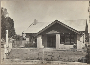 Bendigo Historical Society Inc.
Photograph - T C WATTS & S0N COLLECTION: RUSSELL AND OLINDA STREETS, BENDIGO, 1930
In 1931 electoral rolls, Eric Robert Kevil (1901- 23/5/1980) and his wife lived at 129 Russell St. He had married Edna May Cornish in 1921. By 1943 they had both moved to 77 Valley Pde., Camberwell.Black and white photograph mounted on rectangular brown board. House, pale weatherboard with rough cast above. Corrugated iron roof, one chimney, shingles in gable over verandah, diamond leadlights, bow window L.H., recessed front door rough east surround and pillars to verandah, concave top to verandah wall. Paling side and rear woven wire front and near boundary, lintel over front gate, letterbox. Written on back of photoboard ' Mr. Kevill's Russell and Olinda St., built to order £850 sold, 15.6.34' Date Stamp on back '11 April 1930'Frank A. Jeffree, Bendigorussell street, e.r. kevil, russell street bendigo, t.c. watts and son -
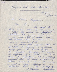 Ringwood and District Historical Society
Letter - clipping, Letter to Town Clerk Ringwood 1939 from Ringwood East Primary re Footpath culvert
A letter dated 30 June 1939 to the Town Clerk Ringwood from E Thompson Ringwood East School Committee advising the Council that the culvert on footpath in Whitehorse Road is in a very bad state of repair. Also requesting that the footpatch be formed or continued along from the Burnt Bridge to the municipal boundary. -
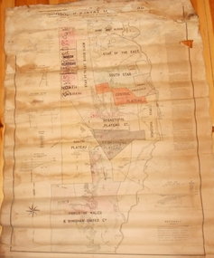 Bendigo Historical Society Inc.
Map - MARKS COLLECTION: MAP MINES BALLARAT AREA 1887
Large buff coloured map, wooden strip on bottom, top hanger missing, showing mine boundaries in Ballarat mining area. Mines include from top of map Bonshaw No. 1; Band and Albion Consolidated Company; Central Bonshaw; North Bonshaw; Star of the East block Claim; Star of the East; South Star; Owen's Freehold; Central Plateau; Sebastopol Plateau Company; Sebastopol Star; Sebastopol Plateau No. 1; South Plateau; Prince of Wales; Bonshaw United company; Gay's Freehold. Map prepared by Robert Alan, under the direction C.W. Langtree, Secretary for Mines, and Chief Mining Surveyor.map, ballarat, ballarat, mining, goldmining -
 Whitehorse Historical Society Inc.
Map - Parish Map, Parish of Nunawading, 1892
... . Shows parish boundaries and land holdings. The area boundaries ...A map copied from 'Directory maps - parishes and counties' dated 26 Nov 1892. Compiled and lithographed by G.S. Bonney. The map includes roads, railway, stations, names of property owners. It has a scale [ca. 1:31,680] 40 chains to an 1 inch.A map copied from 'Directory maps - parishes and counties' dated 26 Nov 1892. Compiled and lithographed by G.S. Bonney. The map includes roads, railway, stations, names of property owners. It has a scale [ca. 1:31,680] 40 chains to an 1 inch.non-fictionA map copied from 'Directory maps - parishes and counties' dated 26 Nov 1892. Compiled and lithographed by G.S. Bonney. The map includes roads, railway, stations, names of property owners. It has a scale [ca. 1:31,680] 40 chains to an 1 inch.maps, parish of nunawading -
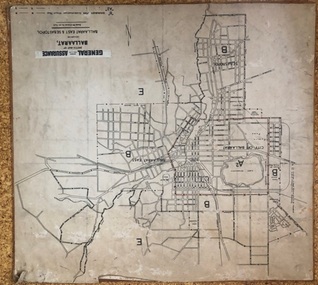 Ballarat Tramway Museum
Map, General Accident Fire and Life Assurance, "Sketch Map of Ballaarat including Ballaarat East and Sebastopol", c1940
Yields information about Ballarat c1940 and how the area was rate for insurance purposes.Map - paper mounted onto a heavy card backing titled "Sketch Map of Ballaarat including Ballaarat East and Sebastopol" with a printed label "General Accident Fire and Life Assurance" pasted to the top of the title. Drawn at 30chains to the inch. Map shows the boundaries between the carious insurance classifications in the district, which relates partly to the local government areas at the time. Shows the Yarrowee, Gong Gong Creeks, rail lines, stations, Black Hill and some other features. Includes the Explosives factory area. Does not show the tram lines.trams, tramways, ballarat, maps, insurance, sebastopol -
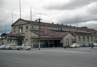 City of Ballarat Libraries
35mm Slide, Alfred Hall, corner Curtis and Grenville Streets, Ballarat circa 1950s
Demolition appears to be under way in this image of the Alfred Hall. It was built in 1867 for the visit of Queen Victoria's son Prince Alfred the Duke of Edinburgh, across the Yarrowee (which formed the municipal boundary) apparently because the municipalities of Ballarat and Ballarat East could not decide who should have the honour! The Alfred Hall held many of the city's events over 89 years, but was symbolically locked up the day the Civic Hall in Mair Street was officially opened, in August 1956. Mrs Bon Strange and her husband Bert were well known Ballarat residents. When Mrs Strange died some years ago, her extensive slide collection was sorted through and those relevant to Ballarat were gifted to the Ballarat Library. alfred hall, curtis street, holden cars, ballarat