Showing 651 items
matching implements
-
 Port Melbourne Historical & Preservation Society
Poster, History of a Street Precinct
A cultural grant was given to Margaret BRIDE to implement this study, which she did with the help of her husband Graham and several residents of the study area including PMH&PS members Emily LOCK, David THOMPSON, Jack BOLT and Kerrie MATHEE.History of a Street Precinct, documenting 80 years plus of the history of the area bounded by Williamstown Road and Evans, Bridge and Farrell Streets, since 1880. One of two products of a 2005 project (which subsequently won the 2007 Victorian Local History Award for research). A brochure containing a map of the area and photos and information on key properties. An interactive CD (2148.02) containing information and photographs on 91 buildings and their occupants over time was also produced. built environment -
Port Melbourne Historical & Preservation Society
Mixed media, History of a Street Precinct
A cultural grant was given to Margaret BRIDE to implement this study, which she did with the help of her husband Graham and several residents of the study area including PMH&PS members Emily LOCK, David THOMPSON, Jack BOLT and Kerrie MATHEE.History of a Street Precinct, documenting 80 years plus of the history of the area bounded by Williamstown Road and Evans, Bridge and Farrell Streets, since 1880. One of two products of a 2005 project (which subsequently won the 2007 Victorian Local History Awards for research). An interactive CD containing information and photographs. This was packaged with a brochure (2148.01) containing a map of the area and photos and information on key properties and individuals on 91 buildings and their occupants over time.built environment -
 Kew Historical Society Inc
Map, MMBW, MMBW Town of Kew, 1910-21
The Melbourne and Metropolitan Board of Works (MMBW) was established by an act of the Victorian Parliament in 1890 to prepare for and to implement a sewerage and water reticulation system across what was then inner Melbourne, its surrounding and middle distance suburbs, including Kew. The MMBW was disbanded in 1991.The map collection of the Kew Historical Society has at its core the historic maps assembled and originally stored in the City Engineer's Department of the City of Kew. These include maps in a number of scales. The vast majority of maps were produced by the MMBW in the first two decades of the twentieth century, and are solid working maps, backed by linen for durability. These maps are historically significant to Kew, the City of Boroondara and to the history of the development of state utilities in Victoria. A number of the Kew maps have additional details added by former municipal officers, including the levels reached by various floods. As these were working documents, information was added to them long after the period of their initial production and distribution.Early map of the Town of Kew, created after 1910, at a scale 440 ft to 1 inch. The 'assembled' map by the City of Kew Engineer's Department includes scaled down copies of The Melbourne and Metropolitan Board of Works maps, Nos. 39, 40, 64, 65, 66, 67, 68, and 117. The map covers the entirety of the Town of Kew, bordered on its north and west by the River Yarra, by Burke Road in the East and Barkers Road in the south. The map shows the extent of urban development by that time, prominent institutions and the outlines of built structures in the municipality. TOWN OF KEW / SCALE 400 FEET TO 1 INCHmelbourne & metropolitan board of works, mmbw maps, mmbw plans, town of kew, cartography -
 Kew Historical Society Inc
Map, MMBW, MMBW Plan No.39 Kew & Heidelberg, 1900-1910
The Melbourne and Metropolitan Board of Works (MMBW) was established by an act of the Victorian Parliament in 1890 to prepare for and to implement a sewerage and water reticulation system across what was then inner Melbourne, its surrounding and middle distance suburbs, including Kew. The MMBW was disbanded in 1991.The map collection of the Kew Historical Society has at its core the historic maps assembled and originally stored in the City Engineer's Department of the City of Kew. These include maps in a number of scales. The vast majority of maps were produced by the MMBW in the first two decades of the twentieth century, and are solid working maps, backed by linen for durability. These maps are historically significant to Kew, the City of Boroondara and to the history of the development of state utilities in Victoria. A number of the Kew maps have additional details added by former municipal officers, including the levels reached by various floods. As these were working documents, information was added to them long after the period of their initial production and distribution.Early map of part of the Borough of Kew, created in the first decade of the twentieth century, at a scale 160 ft to 1 inch. The map covers what was then the north western section of Kew, bordered on its north by Wills Street and the Kew Lunatic Asylum, in the west by the River Yarra [and the later added Yarra Boulevard] , by Princess Street in the East and Holroyd Street in the south. The map shows the extent of urban development by that time, prominent institutions and the outlines of built structures in the municipality. Contour lines were added in ink to the map at a later stage.MELBOURNE AND METROPOLITAN BOARD OF WORKS / PLAN NO. 39 / KEW & HEIDELBERGmelbourne & metropolitan board of works, mmbw maps, mmbw plans, borough of kew, cartography -
 Kew Historical Society Inc
Map, MMBW, MMBW Plan No.40 Collingwood & Kew, 1900-1910
The Melbourne and Metropolitan Board of Works (MMBW) was established by an act of the Victorian Parliament in 1890 to prepare for and to implement a sewerage and water reticulation system across what was then inner Melbourne, its surrounding and middle distance suburbs, including Kew. The MMBW was disbanded in 1991.The map collection of the Kew Historical Society has at its core the historic maps assembled and originally stored in the City Engineer's Department of the City of Kew. These include maps in a number of scales. The vast majority of maps were produced by the MMBW in the first two decades of the twentieth century, and are solid working maps, backed by linen for durability. These maps are historically significant to Kew, the City of Boroondara and to the history of the development of state utilities in Victoria. A number of the Kew maps have additional details added by former municipal officers, including the levels reached by various floods. As these were working documents, information was added to them long after the period of their initial production and distribution.Early map of part of the Borough of Kew, created in the first decade of the twentieth century, at a scale 160 ft to 1 inch. The map covers what was then the south western section of Kew, bordered on its north by Studley Park Road, in the west by Walmer Street and the River Yarra, by High Street South and Princess Street in the East and Barkers Road in the south. The map shows the extent of urban development by that time, prominent institutions and the outlines of built structures in the municipality. Contour lines and historic flood levels were added in ink to the map at a later stage.MELBOURNE AND METROPOLITAN BOARD OF WORKS / PLAN NO. 40 / COLLINGWOOD & KEWmelbourne & metropolitan board of works, mmbw maps, mmbw plans, borough of kew, cartography -
 Kew Historical Society Inc
Map, MMBW, MMBW Plan No.64 Kew & Heidelberg, 1900-1910
The Melbourne and Metropolitan Board of Works (MMBW) was established by an act of the Victorian Parliament in 1890 to prepare for and to implement a sewerage and water reticulation system across what was then inner Melbourne, its surrounding and middle distance suburbs, including Kew. The MMBW was disbanded in 1991.The map collection of the Kew Historical Society has at its core the historic maps assembled and originally stored in the City Engineer's Department of the City of Kew. These include maps in a number of scales. The vast majority of maps were produced by the MMBW in the first two decades of the twentieth century, and are solid working maps, backed by linen for durability. These maps are historically significant to Kew, the City of Boroondara and to the history of the development of state utilities in Victoria. A number of the Kew maps have additional details added by former municipal officers, including the levels reached by various floods. As these were working documents, information was added to them long after the period of their initial production and distribution.Early map of part of the Borough of Kew, created in the first decade of the twentieth century, at a scale 160 ft to 1 inch. The map covers what was then the northern most part of Kew, bordered on its north and west by the Yarra River, in the East by Connor's Creek and by the Asylum in the south. The map shows the extent of urban development by that time, prominent institutions and the outlines of built structures in the municipality. Contour lines and historic flood levels were added in ink to the map at a later stage.MELBOURNE AND METROPOLITAN BOARD OF WORKS / PLAN NO. 64 / KEW & HEIDELBERGmelbourne & metropolitan board of works, mmbw maps, mmbw plans, borough of kew, cartography -
 Kew Historical Society Inc
Map, MMBW, MMBW Plan No.65 Kew & Heidelberg, 1900-1910
The Melbourne and Metropolitan Board of Works (MMBW) was established by an act of the Victorian Parliament in 1890 to prepare for and to implement a sewerage and water reticulation system across what was then inner Melbourne, its surrounding and middle distance suburbs, including Kew. The MMBW was disbanded in 1991.The map collection of the Kew Historical Society has at its core the historic maps assembled and originally stored in the City Engineer's Department of the City of Kew. These include maps in a number of scales. The vast majority of maps were produced by the MMBW in the first two decades of the twentieth century, and are solid working maps, backed by linen for durability. These maps are historically significant to Kew, the City of Boroondara and to the history of the development of state utilities in Victoria. A number of the Kew maps have additional details added by former municipal officers, including the levels reached by various floods. As these were working documents, information was added to them long after the period of their initial production and distribution.Early map of part of the Borough of Kew, created in the first decade of the twentieth century, at a scale 160 ft to 1 inch. The map covers what was then the south central part of Kew, bordered on its north by Malmsbury Street, in the west by Florence Avenue, in the south by Barkers Road, and in the east by Princess Street. The map shows the extent of urban development by that time, prominent institutions and the outlines of built structures in the municipality. Contour lines were added in ink to the map at a later stage.MELBOURNE AND METROPOLITAN BOARD OF WORKS / PLAN NO. 65 / KEW & HEIDELBERGmelbourne & metropolitan board of works, mmbw maps, mmbw plans, borough of kew, cartography -
 Kew Historical Society Inc
Map, MMBW, MMBW Plan No.66 Kew, 1900-1910
The Melbourne and Metropolitan Board of Works (MMBW) was established by an act of the Victorian Parliament in 1890 to prepare for and to implement a sewerage and water reticulation system across what was then inner Melbourne, its surrounding and middle distance suburbs, including Kew. The MMBW was disbanded in 1991.The map collection of the Kew Historical Society has at its core the historic maps assembled and originally stored in the City Engineer's Department of the City of Kew. These include maps in a number of scales. The vast majority of maps were produced by the MMBW in the first two decades of the twentieth century, and are solid working maps, backed by linen for durability. These maps are historically significant to Kew, the City of Boroondara and to the history of the development of state utilities in Victoria. A number of the Kew maps have additional details added by former municipal officers, including the levels reached by various floods. As these were working documents, information was added to them long after the period of their initial production and distribution.Early map of part of the Borough of Kew, created in the first decade of the twentieth century, at a scale 160 ft to 1 inch. The map covers what was then the south eastern part of Kew, bordered on its north by Adeney Avenue, in the west by Sackville Street, in the south by Barkers Road, and in the east by Burke Road. The map shows the extent of urban development by that time, prominent institutions and the outlines of built structures in the municipality. Contour lines were added in ink to the map at a later stage.MELBOURNE AND METROPOLITAN BOARD OF WORKS / PLAN NO. 66 / KEW melbourne & metropolitan board of works, mmbw maps, mmbw plans, borough of kew, cartography -
 Kew Historical Society Inc
Map, MMBW, MMBW Plan No.67 Kew, 1900-1910
The Melbourne and Metropolitan Board of Works (MMBW) was established by an act of the Victorian Parliament in 1890 to prepare for and to implement a sewerage and water reticulation system across what was then inner Melbourne, its surrounding and middle distance suburbs, including Kew. The MMBW was disbanded in 1991.The map collection of the Kew Historical Society has at its core the historic maps assembled and originally stored in the City Engineer's Department of the City of Kew. These include maps in a number of scales. The vast majority of maps were produced by the MMBW in the first two decades of the twentieth century, and are solid working maps, backed by linen for durability. These maps are historically significant to Kew, the City of Boroondara and to the history of the development of state utilities in Victoria. A number of the Kew maps have additional details added by former municipal officers, including the levels reached by various floods. As these were working documents, information was added to them long after the period of their initial production and distribution.Early map of part of the Borough of Kew, created in the first decade of the twentieth century, at a scale 160 ft to 1 inch. The map covers what was then the north central part of Kew, bordered on its north by the Outer Circle Railway Spruzen and Beresford Avenues, in the west by Princess Street, in the south by High Street, and in the east by (about) Belford Road. The map shows the extent of urban development by that time, prominent institutions and the outlines of built structures in the municipality. Contour lines were added in ink to the map at a later stage.MELBOURNE AND METROPOLITAN BOARD OF WORKS / PLAN NO. 67 / KEW melbourne & metropolitan board of works, mmbw maps, mmbw plans, borough of kew, cartography -
 Kew Historical Society Inc
Map, MMBW, MMBW Plan No.68 Kew, 1900-1910
The Melbourne and Metropolitan Board of Works (MMBW) was established by an act of the Victorian Parliament in 1890 to prepare for and to implement a sewerage and water reticulation system across what was then inner Melbourne, its surrounding and middle distance suburbs, including Kew. The MMBW was disbanded in 1991.The map collection of the Kew Historical Society has at its core the historic maps assembled and originally stored in the City Engineer's Department of the City of Kew. These include maps in a number of scales. The vast majority of maps were produced by the MMBW in the first two decades of the twentieth century, and are solid working maps, backed by linen for durability. These maps are historically significant to Kew, the City of Boroondara and to the history of the development of state utilities in Victoria. A number of the Kew maps have additional details added by former municipal officers, including the levels reached by various floods. As these were working documents, information was added to them long after the period of their initial production and distribution.Early map of part of the Borough of Kew, created in the first decade of the twentieth century, at a scale 160 ft to 1 inch. The map covers what was then the north central part of Kew, bordered in the north by Oak Avenue, in the west by the Yarra River and Connor's Creek, in the south by Beresford and Carnegie Avenues, and in the east by Glass's Creek and Burke Road. The map shows the extent of urban development by that time, prominent institutions and the outlines of built structures in the municipality. Contour lines and the levels of historic floods were added in ink to the map at a later stage.MELBOURNE AND METROPOLITAN BOARD OF WORKS / PLAN NO. 68 / KEW melbourne & metropolitan board of works, mmbw maps, mmbw plans, borough of kew, cartography -
 Kew Historical Society Inc
Map, MMBW, MMBW Plan No.117 Heidelberg & Kew, 1900-1910
The Melbourne and Metropolitan Board of Works (MMBW) was established by an act of the Victorian Parliament in 1890 to prepare for and to implement a sewerage and water reticulation system across what was then inner Melbourne, its surrounding and middle distance suburbs, including Kew. The MMBW was disbanded in 1991.The map collection of the Kew Historical Society has at its core the historic maps assembled and originally stored in the City Engineer's Department of the City of Kew. These include maps in a number of scales. The vast majority of maps were produced by the MMBW in the first two decades of the twentieth century, and are solid working maps, backed by linen for durability. These maps are historically significant to Kew, the City of Boroondara and to the history of the development of state utilities in Victoria. A number of the Kew maps have additional details added by former municipal officers, including the levels reached by various floods. As these were working documents, information was added to them long after the period of their initial production and distribution.Early map of part of the Borough of Kew, created in the early twentieth century, at a scale 160 ft to 1 inch. The map covers what was then the north eastern part of Kew showing the natural landscape and limited development on the south side of the Yarra River. In the Kew section, south of the river, the land is occupied currently by the Greenacres and Kew Golf Clubs. The map shows the extent of urban development by that time and the outlines of the few built structures in the municipality. The height above sea level of all parts of the landscape are indicated numerically in feet. Contour lines and the levels of historic floods were added in ink to the map at a later stage. MELBOURNE AND METROPOLITAN BOARD OF WORKS / PLAN NO. 117 / HEIDELBERG & KEW melbourne & metropolitan board of works, mmbw maps, borough of kew, cartography, mmbw plan no. 117, kew (vic.) -- maps, heidelberg (vic.) -- maps -
 Kew Historical Society Inc
Map, MMBW, River Yarra Beautification Schemes, c.1913
The Melbourne and Metropolitan Board of Works (MMBW) was established by an act of the Victorian Parliament in 1890 to prepare for and to implement a sewerage and water reticulation system across what was then inner Melbourne, its surrounding and middle distance suburbs, including Kew. The MMBW was disbanded in 1991.The map collection of the Kew Historical Society has at its core the historic maps assembled and originally stored in the City Engineer's Department of the City of Kew. These include maps in a number of scales. The vast majority of maps were produced by the MMBW in the first two decades of the twentieth century, and are solid working maps, backed by linen for durability. These maps are historically significant to Kew, the City of Boroondara and to the history of the development of state utilities in Victoria. A number of the Kew maps have additional details added by former municipal officers, including the levels reached by various floods. As these were working documents, information was added to them long after the period of their initial production and distribution.Map of the City of Kew showing part of the River Yarra Beautification Schemes. The map shows development to date and the flood levels reached in 1923 and 1924. This map may have been adapted from an earlier map, as most development in central Kew and Studley Park had occurred by this date yet numerous streets are not represented. Public buildings and institutions are clearly represented and named on the map as are significant public transport infrastructure (eg the Outer Circle railway).MELBOURNE AND METROPOLITAN BOARD OF WORKS / RIVER YARRA BEAUTIFICATION SCHEMES / SCHEME / SCALE 10 CHAINS TO AN INCHmelbourne & metropolitan board of works, mmbw maps, mmbw plans, city of kew, flood levels -- kew (vic.), cartography -
![Australian Nursing Federation OH&S campaign badge, [1998-2009]](/media/collectors/5bb42dc221eaf31100db1d3b/items/5c5273c221ea6910d8613b10/item-media/5c5273d121ea6910d8615b65/item-fit-380x285.jpg) Australian Nursing & Midwifery Federation
Australian Nursing & Midwifery FederationAustralian Nursing Federation OH&S campaign badge, [1998-2009]
Button distributed to and worn by Australian Nursing Federation (ANF) members to promote safe movement of patients to reduce workplace injury. The Australian Nursing Federation Victorian Branch implemented the 'No Lifting' (now 'safe patient handling') policy in March 1998. The aim of the policy was to introduce in Victorian healthcare settings an approach to patient handling whereby the manual lifting of patients would be eliminated or minimised wherever possible. This Branch policy and strategies to implement it were a response to high incidence of back pain and workplace injury amongst nurses. The 'No Lifting' policy was accompanied by various conferences and expos to discuss harm minimisation strategies throughout 1998-2009, suggesting this badge is from this period.Circular red, black and white plastic badge. Silver metal, plastic-coated, with safety pin fastener adhered to back. Badge printed with 'I am a No Lifting Nurse', 'Caring for you' and the ANF [Australian Nursing Federation] logo.nurses, nursing, back injuries, occupational health and safety, patient handling, trade unions, professional bodies, workplace injury, accident prevention, badges, buttons, pins, changing healthcare practice, australian nursing federation -
 Ringwood and District Historical Society
Newspaper, Scrapbook Clipping, Library Collection, Ringwood, Victoria
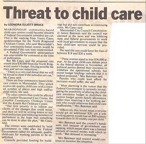
Newspaper Clipping from the "Mail", 30-07-1996. Threat to child care, by Leonora Elliot-BruceMaroondah community based child-care centres could become obsolete if Federal Government susidies are cut, said Tracey Casey, spokeswoman for the North Ringwood Childcare Centre, who said Maroondah's four community based centres would be devastated if the cuts were implemented.``````````````````````````````````````````````` -
 Bendigo Military Museum
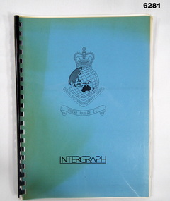
Administrative record - Intergraph Maintenance Programme for Project "Newhart", Intergraph, Suite 6, 1401 Burke Rd, Kew East 3102, 28 August 1992
Intergraph Maintenance by Replacement Proposal (MBR) is the Terms and conditions for the implementation of "Project Newhart" ad the ongoing maintenance of the Automap 2 System. The Document was prepared by Intergraph's Account Manager, Norman John McMurtrie and addressed to LtCol R McHenry, CO Army Survey Regiment.A4 Booklet, Plastic cover, Blue front cover and white rear, Plastic ring binder, RASvy Badge and Text "Intergraph". Pages inserted loose and not secured, includes diagrams and text.royal australian survey corps, rasvy, fortuna, army survey regiment, army svy regt, asr -
 Glenelg Shire Council Cultural Collection
Administrative record - Reports from Meetings - Centenary Celebrations Committee, 1934
A meeting convened by the Mayor Cr J L Wyatt with a view to considering necessary action for the celebration of the State of Victoria at Portland. It was resolved that all present should form as a committee with power to add, with the object of determining and implementing arrangements for the celebration of the Centenary at Portland on the appropriate date. Twenty page booklet, white paper, stapled; containing reports from meetings of centenary celebrations committee and State Centenary Celebrations Co. Pty Ltd. 1930 - 1934. Compiled September 1977.centenary, committee, minutes, administration, 1934, portland sesquicentennial committee, j l wyatt, cr pumpa, cr a hogan, s segal, w millard, beglen, h annett, p hodge, e davis, e n t henry, n learmonth, e andrews, sutton, day, millard, pettit -
 Kiewa Valley Historical Society
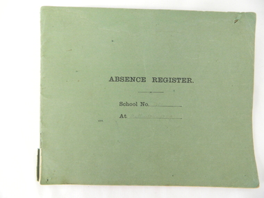
Register School Administration, Absence Register School No. 2539 Mullindolingong, circa 1910
Historical look (early 20th century) at the administrative requirements for the running of a small country school. The level of accountability was limited to a monthly report and a visit from the District Inspector. This was still in the era where paper reporting was utmost and faster electronic reporting had still to be implemented.The significance of this register is that it highlights the need in the early 1900s for travelling time, to and from, the duties required at a small country town to be detailed closely for a bureaucracy that was relatively isolated within the larger cities of Australia. Decentralisation of not only government but also of industry had not as yet entered the Australian environment. This register also shows that the written word was clearly hand scribed and thereby a more personal form of communication. This was still in the age where you " can tell a lot about a person from their handwriting" Lucy Goonan was Leonie Prime's relation and came from Glen Creek to teach at Mullindolingong School for a couple of years. None of the other names are 'known' names from the district.Green coloured cardboard backed book with two large staples holding each page at the left side of the spine Each page of has been folded in half from a 51cm overall length to produce each individual page of the register. This method of production of the book provides 25 double sided pages. Markings on cover " Absence Register, School No........ At ......." Markings on inside cover " ABSENCE REGISTER." Underneath this heading there are six explanatory and conditional usage. Each page is printed with the heading ABSENCE REGISTER and underneath "Roll No. 191(part of initial year reference), Record No. Name of Teacher Position Date of Absence Cause of Absence No. of times absent from beginning of year, total number of days absence and remarks requirements staff /reason/time taken during the period 1923 to 1950. Each page was printed with only three numbers of the calender year 191-.This was so that each year could be manually inserted.teachers absence register small school administration, mullindolingong school 1923 -1950 -
 Melbourne Tram Museum
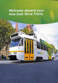
Poster, Yarra Trams, "Welcome aboard your new look Yarra Trams", 2010
Poster -"Welcome aboard your new look Yarra Trams" showing an artist impression of the proposed livery design scheduled to be implemented from 2010. Tram Z2 113 - not know if this tram was actually painted in this livery. The tram was withdrawn from service during 2015.Demonstrates and artists impression of a Yarra trams colour scheme or livery.A3 size sheet printed in full colour.tramways, tramcars, z2 class, tram 113, artist impression, livery, yarra trams -
Federation University Historical Collection
Document - Report, Report to the Council of the University of Ballarat on the Disability Action Plan Report Incorporating the Policy on Inclusion of People with Disabilities for endorsement by Council, 1999, 1999
bility Action Plans was set out in the Commonwealth Disability Discrimination Act (1992) The Chair of the University of Ballarat Disability Action Plan was Professor Philip Candy..1) 12 page report relating to the University of Ballarat Disability Action Plan Project. .2) Memorandum concerning the Disability Action Plan .3) 5 page University of Ballarat Policy on Inclusion of People with Disabilities (Draft) July 1999. .4) 25 page document concerning Implementation of the University of Ballarat Policy on Inclusion of People with Disabilities (Draft 7).disability action plan, commonwealth disability discrimination act, university of ballarat, susanne white, jenny shaw, the resolutions group p/l, university of ballarat policy on inclusion of people with disabilities, disability, impairment, handicap, equal opportunity, phil candy, philip candy -
 Bendigo Historical Society Inc.
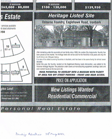
Newspaper - LONG GULLY HISTORY GROUP COLLECTION: OSBORNE FOUNDRY EAGLEHAWK ROAD IRONBARK
Copy of an advertisement from the Bendigo Advertiser 30 May 2001. Advertisement is for the Osborne Foundry, Eaglehawk Road, Ironbark. A photo shows the building with Golden City Implement painted on the front. The foundry had been in the same family for almost seven decades and is now listed for sale. Price on Application. Written underneath is: Bendigo Advertiser 30th May 2001.bendigo, history, long gully history group, the long gully history group - osborne foundry eaglehawk road ironbark, golden city implements, victorian heritage register, bendigo advertiser 30/5/2001 -
 Bendigo Historical Society Inc.
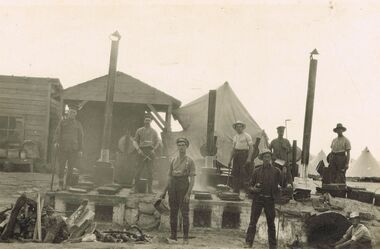
Postcard - ACC LOCK COLLECTION: B&W PHOTO OF A GROUP OF MEN AT A CAMP KITCHEN, POSTCARD, 1914-1918
Postcard, WW1, B&W photo of 8 men at a camp kitchen. Two pairs of ovens and hotplates with chimneys and one inground oven with chimney. Pile of firewood in left foreground. Wooden buildings behind and conical tents in the background. Seven soldiers standing near ovens holding some implements and one soldier sitting at lower right. Location not known.postcard, postcard, ww1, camp kitchen -
Bendigo Historical Society Inc.
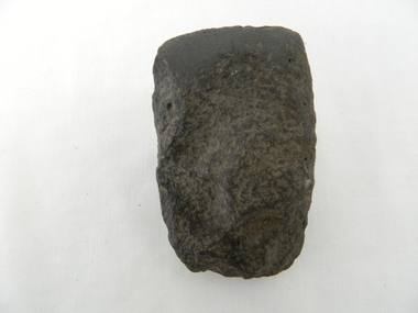
Tool - INDIGENOUS STONE TOOL COLLECTION: AXEDALE AREA STONE AXE HEAD
Dark grey, very hard stone, knapped at one end to sharp edge. Number '8' stuck on stone with tape. Interpretive sign with stone reads ' Stone age implements, exhibits 6 - 10, all found near Axedale, Victoria. Stone axe heads, compare these with a selection of axe heads from the banks of the Loddon, Exhibits 11 - 13' -
 Dandenong/Cranbourne RSL Sub Branch
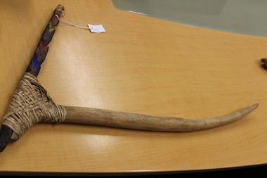
Weapon - Fighting Pick, ca. 1940's
Fighting pick. Appears to be from Papua New Guinea. (fighting pick of Tari.?) Implement in shape of pick with handle and head. Head attached to handle by way of cane binding. Appears to be soft wood handle and head of harder wood. The rear piece of the head behind the binding has carving notches and coloured blue,red,yellow and red inside the carvingpick, fighting pick, tari, papua new guinea -
 Queen's College
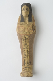
Shabti, New Kingdom, 19th-20th Dynasty, 1295-1069 BCE
This item is part of the Dodgson Collection, which was bequeathed to Queen's College in 1892 by the Rev. James Dodgson. The collection was created by Aquila Dodgson, brother of James. Aquila Dodgson was a friend of the English Egyptologist Flinders Petrie, and it was through this friendship the Aquila was able to acquire ancient Egyptian artefacts. A detailed study of the collection was made by Christine Elias "Discovering Egypt: Egyptian Antiquities at the University of Melbourne", M.A. thesis 2010.Upper half, feet and band running down front of figure is yellow outlined in red. Face, wig and hieroglyphs on front in black, crossed arms holding implements in red. On back across shoulders representation of a basket and outline of arms in red. Yellow on upper half and on feet on back of figure. Small paper label inscribed with 'A9' attached to back.james dodgson, aquila dodgson, flinders petrie, wood, shabti -
 Kiewa Valley Historical Society
Squeegee - Tea Tree, circa mid to late 1900's
This "home made" squeegee was manufactured in the mid to late 1900's by an ingenuous dairyman as a solution to the removal of cow "pats" from the concrete floors of his "milking" sheds. The tea tree made squeegee (being made from nature's anti bacterial material) was an excellent hygienic implement to use. This "home made" wooden squeegee is very significant to the Kiewa Valley and its surrounding regions because it highlights the natural ingenuity found in the pioneer farmer, grazier and other rural folk. It demonstrates the "mother of invention and adaptation" is very strong in rural areas where "off the shelf" products were a rare quantity. Part of the natural psyche of the rural Australian inhabitants is the ability to produce inventions that overcome physical restrictive conditions, "the man/woman of all trades" is an apt description of the pioneers of yesteryear and of those to come.The squeegee handle is a long branch made from a tea tree, inserted into the upper flat side of a slab of tea tree wood which is flat on one side and curved on the other, the natural curve of the tree trunk. This squeegee was used on dairies for removing cow manure.timber, dairy, farm, rural, implement -
 Kiewa Valley Historical Society
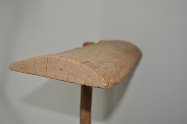
Axe Head, Before European settlement
This item was used well before European settlement and clearly demonstrates the development of the local Aboriginal tribes, Dhudhuroa and Yaitmathang in the use of a cutting /chopping implement, made from Mount William sourced material i.e. greenstone. This item was probably traded at the Bogong Mountain tribal yearly summer ceremoniesThe significance of this item places it at the fore front of human development in this region. The period when this tool was manufactured represents the time when the natural landscape had not been altered and the natural vegetation, fauna and flora, had not been subjected to imported species.This also proves that local tribes did live in this area and or the Bogong High Plains.Small ground edge stone axe head. Leading cutting edge very smooth and chiseled to a fine edge. Weight is, for its size fairly heavy. It is made from Greenstoneaboriginal tool stone ground-edge axe indigenous tool -
Bendigo Historical Society Inc.
Tool - INDIGENOUS STONE TOOL COLLECTION: AXE HEAD OR SCRAPER, AXEDALE AREA
Brown stone, has slight granite appearance. Short edge knapped to provide a sharp edge. Number 10 stuck on stone with tape. Interpretive sign with item reads' Stone Age Implements, exhibits 6 - 10, all found near Axedale, Victoria. Stone Axe heads ( compare these with a selection of Axe Heads from the banks of the Loddon, Exhibits 11 - 15) -
 Tennis Australia
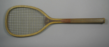
Racquet, Circa 1906
A wooden, transitional flat-top racquet with a laminated convex throat. Decal profile bust image across throat on obverse is of a male North American native. Inscription across right side of stem is largely lost, but originally read: THE BRIDGEPORT GUN IMPLEMENT CO./NEW YORK, U.S.A. Materials: Wood, Gut, String, Leather, Metal, Ink, Glue, Lacquertennis -
 Charlton Golden Grains Museum Inc
Photograph, Charlton Motors Service Station c. 1920, c.1920
Charlton Motors Service Station agents for cars, motorcycles and tyres. Established c. 1911 in the former Malcolm's Flour Mill building. The flour mill was established in 1876 and closed in 1911. The business was operated by Mr LazarusBlack & white photo, mounted, unframed. Charlton Motors Pty Ltd Service Station, corner of Armstrong and High streets. Five men in front of service Station, one man in front of Massey Harris building. Large telegraph pole on corner. Signage on buildings advertising Dunlop & Goodyear tryes, Buick and Indian motorcycles. Massey Harris Farming Implements, Wischers ?, Lazarus ?charlton motors, charlton, armstrong street -
 Bendigo Historical Society Inc.
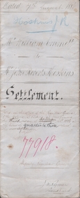
Legal record - EMMETT William, Watson, James & Rogers, Rogers Collection, 1886
In the early 1980s the firm of Watson, James & Rogers merged with the partnership of Every & Every and became the iconic “Rogers & Every” as known today. The firm is still located on Bull Street. https://rogersevery.com.au/about/* Indenture between William Emmett of Mologa, Farmer, and John Roberts Hoskins of Sandhurst, Timber merchant. Dated August 1886. * Assignment between William Emmett of Mologa, Farmer, and John Roberts Hoskins of Sandhurst, Timber merchant. Dated August 1886 * Account of Sales of horses, cattle, Farm implements etc. sold at auction on account of William Emmett by R O'Neil, Auctioneer.Signaturesr o'neill, j r hoskins, timber merchant