Showing 1620 items
matching junction
-
 Ballarat Tramway Museum
Slide - 35mm slide/s, Ben Parle, 8/04/1958 12:00:00 AM
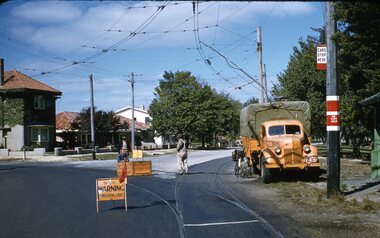
Kodachrome Transparency - 35mm slide - cardboard mount, with one side with red border and words "Kodachrome Transparency / Processed by Kodak" top and bottom. Photo taken by Ben Parle 8/4/1958. Has slide No. "5" stamped in black in top corner. Photo of the SEC Ballarat Ford welding truck, at the intersection of Macarthur St and Wendouree Parade, View Point Junction. Note tram stop signage. Three SEC workers in view, with road signage set up and truck connected to the overhead for welding work. Note bicycle leaning against truck. Welder - Weld For high resolution scan see btm2864.tif See Reg Item 7700 for another photo of the truck in the Power Station yard. "Drummond St. and View Point Junction Ballarat" / "8-4-58"tramways, trams, rails, welding, trucks -
 Kiewa Valley Historical Society
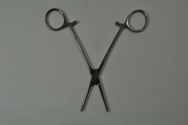
Straight Spencer Wells Artery Forceps
This medical / hospital instrument was used in the Tawonga District General Hospital which was built specifically in the 1950s for the increase in population due to the Kiewa Hydro Scheme.Historically Significant: Shows the development of scientific hospital equipment. Provenance: Used in the Tawonga District General Hospital which was remote and therefore required good equipment.Rachet Closure to Clamp Arteries Metal shaped like scissors - serrated across at end for gripping. Finger grips have 3 teeth attached both sides to hold arteries firmly and permanentlyT.D.G.H. on one side (at junction) LRI / STAINLESS on other side (at junction) medical equipment. hospital equipment. mt beauty. tawonga. medical. hospital. nurse. doctor. artery. scissors. spencer wells. forceps. artery. -
 Whitehorse Historical Society Inc.
Article - John Gardiner, 23/06/2021
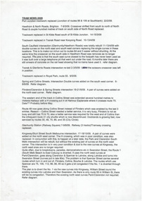
John Gardiner was born in Dublin 1798. He was a pastoralist and banker and arrived at Port Phillip in 1836 and with his cousin William Fletcher laid claim to 15,000 acres at the junction of the Yarra River and Kooyongkoot CreekJohn Gardiner was born in Dublin 1798. He was a pastoralist and banker and arrived at Port Phillip in 1836 and with his cousin William Fletcher laid claim to 15,000 acres at the junction of the Yarra and Kooyongkoot Creek.non-fictionJohn Gardiner was born in Dublin 1798. He was a pastoralist and banker and arrived at Port Phillip in 1836 and with his cousin William Fletcher laid claim to 15,000 acres at the junction of the Yarra River and Kooyongkoot Creekgardiner john, gardiners creek -
 Melbourne Tram Museum
Document - Report, Peter Carwardine, David Mehlman, "Tram News 2009", Dec. 2009
Report - two A4 sheets with hand drawn tram junctions titled "Tram News 2009" listing the various track work undertaken at junctions during 2009, establishment of route 3A, Franchise agreements and Yarra Trams as operators of the tram network. Junctions listing - South Caulfield, Collins and Spring St, Spring and Flinders St, Kingsway and Sturt St, Carlisle St and Esplanade (Luna Park) and Acland St. Compiled by Peter Carwardine and David Mehlman Dec. 2009.trams, tramways, trackwork, junction, hawthorn rd, south caulfield, glenhuntly rd, spring st, flinders st, collins st, luna park, kingsway, sturt st, carlisle st, esplanade, acland st -
 The Beechworth Burke Museum
Photograph, c1924
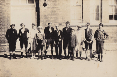
Taken in 1924, depicted are eleven young men dressed in school uniform attire standing in the playground of Beechworth State School. This group of young men were part of a farcical play titled "School Days" as part of Beechworth State School Concert series. Beechworth Primary School (formally known as Beechworth State School) was constructed in 1875 by architect Henry Bastow (1839 - 1920). Bastow was the chief architect and surveyor for the Victorian Government’s Department of Education. During his chiefship, over six-hundred schools were constructed across the state which was in response to the Victoria’s Education Act of 1872 legislating free, compulsory, and secular education. Performances such as this “School Days” play were common forms of entertainment within Beechworth up into the early twentieth century. This stems from the goldrush period in Beechworth (1852-1866) when travelling entertainers would tour the goldfields offering performances in singing, acting and circus tricks. These were usually held in a local pub or designated concert spaces, such as the Star Theatre in Beechworth. Entertainment offerings begun to slow down mid-twentieth century when the population begun to dwindle. Many locals took up this responsibility and put on their own plays and shows across the town. This photograph is historically significant as it provides insight into the types of entertainment activities held at the Beechworth School during the early twentieth century. It also demonstrates how students engaged with their school outside of their regular schoolwork. Black and white rectangular photograph printed on matte photographic paper mounted on board. Obverse: W.Howes / Beechworth Concert Party 1924 / State School / Beechworth Cyril Smith (Squidgy) / Keith Prowse / Bill Howes / J. Warde / J. Heatherly (Jumbo) / Gea Foster / B. Shallard (Shinky) / A. Foster / Ernie Smith / Jerry Burns / Ted Warden / School Master / Geo Foster in a Farscial Play “School Days” / Reverse: A03065 / 1997.2520 / 79.19.1 / school uniform, beechworth school, school days", concert series., henry bastow, beechworth primary school, victorian government’s department of education, education, victoria’s education act of 1872, beechworth state school -
 Orbost & District Historical Society
book, Vic Roads Centenary 1913 -2013, 2013
The publication, VicRoads Centenary: Keeping Victorians Connected for 100 Years, looks at the people and projects that define VicRoads’ history. Written by current and former VicRoads’ employees, the publication details the organisation’s portfolio of major projects, which includes the Great Ocean Road, Hume Highway and Eastern Freeway. Other sections report on Victoria’s world-first road safety initiatives, VicRoads’ use of technology and sustainability measures. (ref VicRoads) This item is one of several books donated by David Jellie at a presentation to Orbost Historical Society. He was a contributor to the book and was the engineer for the Snowy River Bridge (Princes Highway) at Orbost 1974-1976.This book is a useful reference tool on the history of road construction in Victoria including East Gippsland.A thick, bound paperback book, titled "VicRoads Centenary Keeping Victorians Connected for 100 Years". On the front cover is a black/white photograph of two men working on a road. One has a pick. The book contains the history of VicRoads, photographs, maps and advertisements. Some are b/w. Others are coloured.vicroads book roads snowy-river-bridge jellie-david -
 St Kilda Historical Society
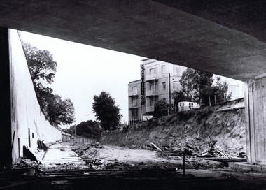
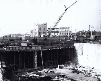
Photograph, St Kilda Juncton Construction Queens Rd underpass, c. 1967
hand written on back: Queen's Road underpass. Photo filed 11.12.1967 Shows a building with a large vertical neon sign 'Recruiting'black and white matt photograph good condition unmountedQueen's Road underpass. Photo filed 11.12.1967 L16514/5 H71. Copyright. This photograph may not be reproduced without permission in writing from the Editor of "The Age". 250 Spencer Street, Melbourne and 39/41 York st, Sydney. -
 St Kilda Historical Society
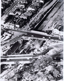
Photograph, Queens Way Underpass, Under construction 1968, c. 1968
aerial view. hand written on back: Queens Way underpass under construction. Photo filed 30.4.1968black and white photograph in plastic coverQueen's way Underpass Under Construction 1968 "Age". Photo filed 30.4.1968. V6429 H71 C170. Copyright. This photograph may not be reproduced without permission in writing from the Editor of "The Age". 250 Spencer Street, Melbourne and 39/41 York st, Sydney. -
 St Kilda Historical Society
Photograph, The Queen's Way underpass, c. 1967
shows constructionblack and white matt photograph good condition unmountedThe Queen's Way underpass. Photo filed 11.12.1967. L15119 H71. Copyright. This photograph may not be reproduced without permission in writing from the Editor of "The Age". 250 Spencer Street, Melbourne and 39/41 York st, Sydney. -
 St Kilda Historical Society
Photograph, Queens Way underpass under construction, c. 1967
hand written on back: Queens Way underpass under construction 1967/68?black and white photograph fair condition unmountedQueen's Way Underpass under construction. 1967/68. C14. H71. Copyright. This photograph may not be reproduced without permission in writing from the Editor of "The Age". 250 Spencer Street, Melbourne and 39/41 York st, Sydney. -
 St Kilda Historical Society
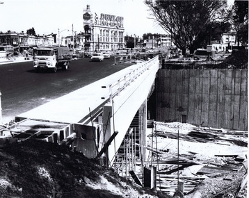
Photograph, Wellington St bypass, c. 1968
picture shows ramp from St Kilda Road to by-pass road filed 22.10.68black and white photographAge photo V18369 (titled 22.10.68). Trams using Wellington St by-pass for first time. Picture shows ramp from St Kilda Rd to by-pass road. Copyright. This photo may not be reproduced without permission in writing from the editorof "The Age". 250 Spencer Street, Melbourne and 39/41 York Street, Sydney. -
 Uniting Church Archives - Synod of Victoria
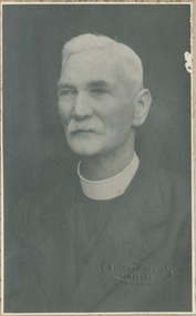
Photograph, Undated
Rev. Oliver Dowsing. Began his ministry in 1891, in Camperdown. Retired in 1930.B & W matte head and shoulders portrait of the Rev. Oliver Dowsing. Mounted in card display folder.methodist, minister, rev. oliver dowsing, camperdown. -
 Uniting Church Archives - Synod of Victoria
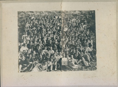
Photograph, 1927
A report in "The Spectator" May 4 1927 noted that 300 - 400 men and boys attended the Easter camp.B & W photograph mounted on buff card of a large group of men and boys gathered on sand dunes at Ocean Grove. Young Men's Methodist Camp 1927 Ocean Grovemethodist, camp, ocean grove -
 Uniting Church Archives - Synod of Victoria
Photograph, 1926
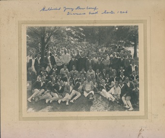
Rev A. Vincent of Ballarat is seated at the centre of the group.B & W photograph mounted on buff card of a large group of men and boys gathered outdoors at Diamond Creek. Methodist Young Men's Camp Diamond Creek Easter 1926 -
 Uniting Church Archives - Synod of Victoria
Photograph, 1925
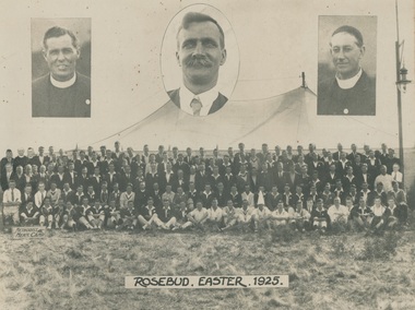
160 young men attended the second annual camp of the Methodist Young Men's Bible Class League. The first camp was held at Healesville in 1924. B & W photograph mounted on buff card of a group of men and boys at the Methodist Men's Easter Camp held at Rosebud in 1925. Three head and shoulder photographs have been inset. Inset: Rev Horton Williams (left), Rev A. Vincent Ballard (right). Man in centre tentatively identified as Edward Frederick Goodall Hodges, Healesville Shire President.methodist young men's bible class league, camp, rosebud, rev. horton williams, rev a. vincent ballard -
 Hume City Civic Collection
Photograph, Early 1980's
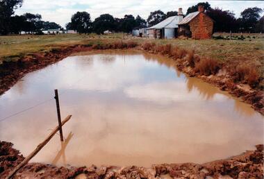
The mud brick cottage and outbuilding was possibly built by James Waylett in the 1850's and it is only one of three remaining mud brick buildings in the Oaklands-Greenvale which were constructed in the late 19th Century.A coloured photograph of farm scene. A dam is in the foreground and the remains of a mud brick cottage and timber and corrugated building in the middle distance. Further farm buildings can be seen in the distance.mud brick buildings, waylett, james, farm buildings, sherwood, somerton road, oaklands hunt club, george evans collection -
 Ararat Gallery TAMA
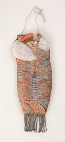
Mixed media, Inga Hunter, Cat in an Overcoat, 1982
-
 Sunbury Family History and Heritage Society Inc.
Photograph, Painting with lime wash, 1992
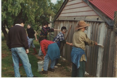
In 1992 the children from the Bulla Primary School had an excursion to Woodlands Park for a Colonial Day where they were introduced to old crafts and skills. In this photograph the children were painting a shed using lime wash instead of commercially produced paint.The purpose of this school excursion was to introduce the children to day to day living in colonial times in Australia by giving them a hands on experience in a number of crafts and leisure time pursuits.A coloured photograph of five children painting a shed wall under the supervision of an adult. One person is mixing the paint while three others are doing the painting.bulla primary school, woodlands park, school excursions, colonial crafts -
 Sunbury Family History and Heritage Society Inc.
Photograph, Woodlands Homestead, c1990
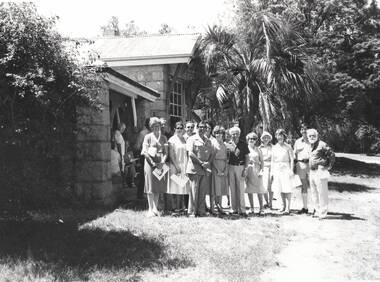
Woodlands Homestead is the building in the photograph and the people standing at the entrance must have been invited by the former Shire of Bulla to visit the property when it became a tourist attraction. Des. Dumbrell, the gentleman wearing the light safari suit and standing in the front was one of the local councillors when Woodlands was opened to the public in the 1990. The park later became a home for retired racehorses.Woodlands Park became a popular tourist park within the area with many varied attractions which include the prefabricated homestead, native fauna and flora and mt. Gellibrand, the highest point in the park. A non-digital black and white photograph with a cream border, of a partial view of the entrance to a homestead built from stone with a galvanised roof. Nineteen people are gathered as a group at the main entrance. A palm tree is immediately behind the group with larger trees in the background.woodlands park, woodlands homestead, oaklands junction, shire of bulla -
 Clunes Museum
Financial record - PHOTOCOPIED LEDGER ENTRIES, John Spark Leather Ledger dated 1870's
130 PHOTOCOPIED PAGES FROM A SMALL LEATHER LEDGER -1872-1873-1874 &1875 owned by John Spark who later had a butcher Shop at 27 Fraser Street. Likely to be his droving recordsJOHN SPARK THE JUNCTION - written on front. The Junction referring to his property on the road to Maryborough. local history, books, accounts, spark's butcher shop -
4th/19th Prince of Wales's Light Horse Regiment Unit History Room
Junction Distribution Box No 8
Part of the radio control harness for tanks using the larkspur radio systemAs used by the Regiment in a previous life as a Tank RegimentAluminium box with three coupling positions with a volume control and call switchJunction Distribution Box No8control box, radio harness, jd 8 -
 Melbourne Tram Museum
Slide - Set of 2, Keith Kings, 24/12/1967 12:00:00 AM
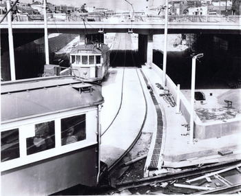
Set of two 35mm Kodak white cardboard colour slide by Keith Kings of 24/12/1967 - .1 - St Kilda Junction, looking north along St Kilda Road, showing the nature of the diversion from the junction for Wellington St. .2 - Dandenong Road, showing the track diversion work for Dandenong Road/Queensway, Windsor.Keith Kings stamp and number "15-1" and "15-5"", with details of exposure. .1 - SW6 car on temporary track at St Kilda Junction looking north from turnout during freeway work .2 - Dandenong Road west from Hornsby St with section of straight track ready to replace curves onto new b.v.w. track to Chapel St - 907 coming off soon to be abandoned street track.trams, tramways, st kilda junction, trackwork, road works, dandenong road, queensway, tram 907 -
 Kiewa Valley Historical Society
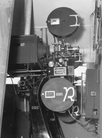
Photograph – Black and white photograph of an unidentified piece of equipment (possibly projection equipment) presumably used by SECV Hydro
The Victorian Government took control of power generation in 1921, forming the State Electricity Commission (SEC). Construction approval on a grand scheme to build five power stations with a combined capacity of 289 megawatts was received in 1938, and the Clover Power Station was completed by 1945. The original scheme was dramatically pruned after World War II and only two more power stations were built. The Junction Dam and Clover Dam Power Station, stages of the Kiewa Hydro-Electric Scheme, were needed to meet the increased power demands of the wartime industry in Victoria. Clover added 26 megawatts to the grid. Junction Dam was completed and ready to hold water by September 1943, but was emptied in December 1943 and not filled again until May 1944. Construction of Clover Power Station commenced in July 1941 and both turbines were in service by May 1945.Clover Power Station and Junction Dam were part of the Kiewa Hydro Electric Scheme constructed by the State Electricity Commission of Victoria.Black and white photograph of an unidentified piece of equipment (possibly projection equipment) presumed to be used in one of the power stations ie: Clover Power Station or Junction Dam as part of the Kiewa Hydro Electric Schemeprojection equipment; -
4th/19th Prince of Wales's Light Horse Regiment Unit History Room
Junction Distribution Box No 9, 1950s - 60s
Equipment used by the RegimentBox of aluminium construction with couplings and controls for the management of up to three radio sets.Junction box, wireless control harnessjunction box, wireless control harness -
 Melbourne Tram Museum
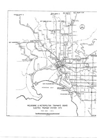
Drawing, Melbourne & Metropolitan Tramways Board (MMTB), "Melbourne & Metropolitan Tramways Board Electric Tramway System 1979", 1979
Photocopy of the track plan for the Melbourne Tramway System in 1979 over two separate sheets - titled "Melbourne & Metropolitan Tramways Board Electric Tramway System 1979". Shows the route numbers and terminus names, depot locations, rail lines, cross overs and junctions. Has the name J.Chau in bottom left hand corner.trams, tramways, melbourne, map, trackwork, depots, route numbers, railways, junction -
 Melbourne Tram Museum
Document - Folder with papers, John Prideaux, "Passenger Counts", 1971 to mid 1970's
Manila folder mark on the spine "MMTB Pass Count 1971 - 1983" - containing some 24 photocopied foolscap sheets of instructions and lists of names of people involved, including the donor for passenger counts at various points. Often includes a small diagram of where counts were to be taken at junctions - example for Oct. 1975 Inbound Peak scanned - See images i2 to i6. Also includes a count for the Eucharistic Congress Feb. 1973 Set of 8 stapled sheets of examples of actual counts done by the donor - form 3/201, carbon copies giving date, routes, points and checker name.trams, tramways, mmtb, passengers, junction, eucharistic congress -
 Kew Historical Society Inc
Photograph - Kew Junction, Herald & Weekly Times, 1962
This is an aerial oblique image looking north. It shows Kew Junction before construction of VicRoads (Country Roads Board), Murphy's (Leo's) supermarket, and office towers. It also shows a building on the land now known as the Raoul Wallenberg Reserve, the Kew Municipal Offices in Walpole Street, and St Paul's School for the Blind in Fernhurst Grove, and Kew Bowling Club in Wellington Street.An aerial photograph of Kew Junction, showing the intersection of High Street South, Studley Park Road, Princess Street, High Street and Denmark Street. A number of buildings, now demolished can be identified in the photo, including Jellis’ Bakeries on the corner of Princess Street and Studley Park Road." Annotation on reverse: "Kew Historical Society from Mr L. H. Chinner".kew junction, aerial photograph (kew), oblique aerial, st paul's school for the blind, kew municipal offices, high street kew, studley park road, kew war memorial, kew post office, kew police station, kew court house, high street south, kew, wellington street kew, denmark street kew -
 Melbourne Tram Museum
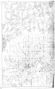
Drawing, Melbourne & Metropolitan Tramways Board (MMTB), "Plan of Tramway System - showing route mileage of electric tramways", Late 1960's
Drawings - dyeline print - titled - "Plan of Tramway System - showing route mileage of electric tramways" - Principal Junctions and intersections shown diagrammatically. Map of system shown at 40 chains to the inch. Drawing No. P6050. Shows crossovers, signal cabins, automatic points, closed cable tram lines in the city area, roads, railways and stations. Originally signed by Perway Engineer - 31-7-1951, last update March 1963. Has a list in the bottom left hand corner of abandoned cable tram lines. See Reg Item 1638 for a 1987 version and 3642 for a 1941 version.trams, tramways, mmtb, trackwork, tramways, junction, map -
Upper Yarra Museum
senior fellowship powelltown union church, 30 july 1934
The exercise book contains meeting minutes from the Powelltown Union Church Senior Fellowship.The first minutes are from July 30 1934, the last from 15/7/36. The Fellowship's Rules are listed near the back of the book.The Powelltown Church was an unusual Union Church. Fellowship members listed in the minutes have links with original and recent residents.The minutes provide primary insights into the Powelltown community,Fellowships and contemporary matters. Front and back covers provide examples of contemporary advertisements.ruled exercise book green coloured ads un front and back covers l230mmxw180mmmiss marion adams secty warburton yarra junction powelltown. union church. senior fellowships.advertisements. warburton. yarra junction. district state schhols -
Coal Creek Community Park & Museum
Glass Bottle
Small clear (with green tint) square glass bottleWM Johnson & Son Chemists. Junction St Kilda.