Showing 558 items
matching kew gardens
-
 Kew Historical Society Inc
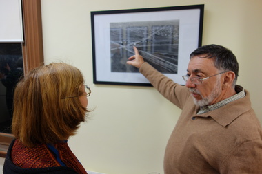
Photograph - Digital Photographs [Series], Robert Baker, Exhibition: Kew From Above, Kew Court House, 2014, 2014
The Kew Historical Society, founded in 1958, is one of the oldest continuing historical societies in the Greater Melbourne region. From its beginnings, the Society has mounted exhibitions and/or displays, in early days in shop windows and in community spaces located in the Kew City Hall (later Kew Library), and since 2010 at the Kew Court House. Exhibitions typically coincided with the annual Kew Community Festival in March, but after 2013 evolved into three new exhibitions yearly at the Kew Court House. Smaller displays continue to be mounted in the Kew Library. A born digital photograph of members and guests at the exhibition opening. Photo 1: L-R Terryl de Lacey, Janet Walker, Don Garden Photo 2: Les Littlechild, Sue Littlechild, Ian Job, ..., ... Photo 3: John Torpey, Slavka Jelovac kew historical society - exhibitions, exhibition - aerial photographs - kew (vic) -
 Kew Historical Society Inc
Photograph - Photographs [Series], Noel Kelly, 60th Anniversary Meeting, Kew Historical Society, September 2018, 12/09/2018
The Kew Historical Society was founded at a meeting called by the Kew Association in September 1958 at the home of Cr. WHS Dickinson, who was to become the first president of the Society.AGM of the Kew Historical Society coinciding with the 60th anniversary of the Society. The guest speaker was the Mayor of Kew, Cr. Jim Parke, while the patron of the Society, Sir Gus Nossal made presentations and cut the birthday cake. Presentations in recognition of service were made to Assoc. Prof. Don Garden, Brad Miles, and David Benwell.kew historical society inc -- anniversaries, kew historical society inc - agms -
 Kew Historical Society Inc
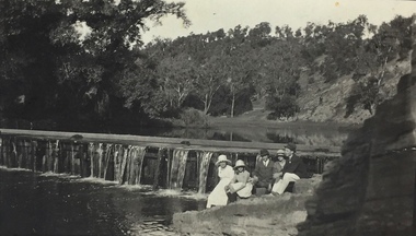
Photograph, Richardson Family at Dight's Falls, 1920
Dight’s Falls in Studley Park is an artificial weir built on a natural rock bar across the Yarra. The weir was built in the 1840s to provide water to the ‘Ceres’ flour-mill, one of the first in Victoria. The falls were later to become known as Dight’s Falls after the owners of the mill. Later, a pumping station was built on the Kew side of the river, which pumped water uphill to a reservoir in Walmer Street that provided water to the Melbourne Botanical Gardens and to Albert Park Lake. The area around Dight’s Falls was and is frequently used for recreational activities.This photograph forms part of the collection assembled by the historian Dorothy Rogers, that was donated to the Kew Historical Society by her son John Rogers in 2015. The manuscripts, photographs, maps, and documents were sourced by her from both family and local collections or produced as references for her print publications. Many were directly used by Rogers in writing ‘Lovely Old Homes of Kew’ (1961) and 'A History of Kew' (1973), or the numerous articles on local history that she produced for suburban newspapers. Most of the photographs in the collection include detailed annotations in her hand. The Rogers Collection provides a comprehensive insight into the working habits of a historian in the 1960s and 1970s. Together it forms the largest privately-donated collection within the archives of the Kew Historical Society.Black and white photograph of the Richardson family seated on the Kew side of Dight's Falls in 1920. One of the girls in the photograph was to become the Melbourne historian Dorothy (Richardson) Rogers.Annotation on reverse: "Mrs D. Rogers, 29 Park Crst Kew. Dights Falls 1920"dight's falls - kew (vic) - fairfield (vic), sport and recreation - kew (vic), dorothy rogers -
 Kew Historical Society Inc
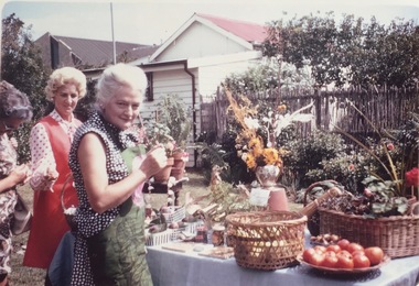
Photograph - Kitty's Garden Stall, 'Houghton', 1971
Houghton in Princess Street Kew was an early Victorian cottage at one stage owned by a relative of the Beath family in nearby Ivy Grange. Their is a chapter on Houghton in Rogers, Dorothy (1961) Lovely Old Homes of Kew. At the time of then photo, accomodation for war widows had been built on a portion of the site.Colour photograph of participants at a local fundraising stall in Kew in 1971.At the home of Connie Howells Mar 18 1971. Curry luncheon in aid of C.A.A. Kitty's Garden Stall.houghton - kew (vic), vasey house -- kew (vic), houses -- princess street -- kew (vic.) -
 Kew Historical Society Inc
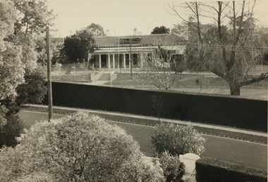
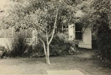
Photograph, Glendonald School for the Deaf, Marshall Avenue, 1960-1970
Glendonald School for Deaf Children was run by the Victorian Education Department. It provided education and some residential services for deaf children. The school was situated in Marshall Avenue, Kew and operated from 1951–91. Deaf children whose families lived too far to travel daily were housed in a grand Victorian mansion in Belmont Avenue, Kew, the John Cannon Hostel. The school and hostel also accommodated a small number of wards of the state. Source: Glendonald School for Deaf Children (1951–91); https://www.findingrecords.dhhs.vic.gov.au/collectionresultspage/GlendonaldSchoolforDeafChildren; Accessed 05/09/2018.Glendonald was a significant mansion in Kew (now demolished) built for the industrialist and manufacturer Donald Leslie in 1886. The school was purchased by the Victorian Department of Education on 29 November 1950 for the sum of 16,500 pounds.Photograph of the front garden of Glendonald taken from Marshall Avenue."The old school for the deaf at 17 Marshall Ave for children from the age of six years to ten years old, then they would go to 25 Marshall Ave to finish their schooling leaving age 16 years old."glendonald - marshall avenue - kew (vic), education - deaf children - victoria -
 Kew Historical Society Inc
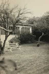
Photograph, Glendonald School for the Deaf, Marshall Avenue, 1955-1965
Glendonald School for Deaf Children was run by the Victorian Education Department. It provided education and some residential services for deaf children. The school was situated in Marshall Avenue, Kew and operated from 1951–91. Deaf children whose families lived too far to travel daily were housed in a grand Victorian mansion in Belmont Avenue, Kew, the John Cannon Hostel. The school and hostel also accommodated a small number of wards of the state. (Source: Glendonald School for Deaf Children 1951–91)Glendonald was a significant mansion in Kew (now demolished) built for the industrialist and manufacturer Donald Leslie in 1886. The school was purchased by the Victorian Department of Education on 29 November 1950 for the sum of 16,500 pounds.Trampoline in the garden of Glendonald, Marshall Avenue (Kew).The old school for the deaf at 17 Marshall Ave for children from the age of six years to ten years old, then they would go to 25 Marshall Ave to finish their schooling leaving age 16 years old. glendonald - marshall avenue - kew (vic), education - deaf children - victoria -
 Kew Historical Society Inc
Photograph, Glendonald School for the Deaf, Marshall Avenue, 1955-1965
... Garden, Glendonald, Marshall Avenue (Kew)....) Glendonald was a significant mansion in Kew (now demolished) built ...Glendonald School for Deaf Children was run by the Victorian Education Department. It provided education and some residential services for deaf children. The school was situated in Marshall Avenue, Kew and operated from 1951–91. Deaf children whose families lived too far to travel daily were housed in a grand Victorian mansion in Belmont Avenue, Kew, the John Cannon Hostel. The school and hostel also accommodated a small number of wards of the state. (Source: Glendonald School for Deaf Children 1951–91)Glendonald was a significant mansion in Kew (now demolished) built for the industrialist and manufacturer Donald Leslie in 1886. The school was purchased by the Victorian Department of Education on 29 November 1950 for the sum of 16,500 pounds.Garden, Glendonald, Marshall Avenue (Kew).The old school for the deaf at 17 Marshall Ave for children from the age of six years to ten years old, then they would go to 25 Marshall Ave to finish their schooling leaving age 16 years old. glendonald - marshall avenue - kew (vic), education - deaf children - victoria -
 Kew Historical Society Inc
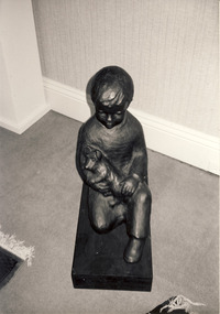
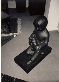
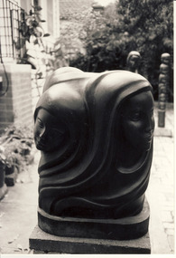
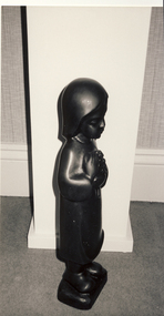
Photograph, Leopoldine Mimovich, Bronze Sculpture : Boy With Dog, 1990
... and in the Alexandra Gardens. artists - kew (vic) leopoldine (poldi) mimovich ...Leopoldine Mimovich was born in 1920, in Neumarkt in the Italian Tyrol. In 1940, aged 20, she moved to Vienna where she studied clay modelling and drawing. From 1943 she attended the School of Wood Sculpture in Hallstatt, graduating in 1947. Following her marriage to Ljubisa Mimovich, the couple migrated to Australia in 1949 travelling on MV Skaugum. After an initial period at Bonegilla and Royal Park Migrant Hostels the couple moved to Yarraville and then to 33 Miller Road, Kew, where she established her studio. A wood sculptor, painter and etcher, she was awarded an OAM for services to the arts in 1985. Examples of her sculptures in Kew can be found in the Kew Library and in the Alexandra Gardens. Black and white photograph of sculpture or sculptures by Leopoldine Mimovich photographed in her home at 31 Miller Grove, Kewartists - kew (vic), leopoldine (poldi) mimovich -
 Kew Historical Society Inc
Photograph, Leopoldine Mimovich, Bronze Sculpture : Boy With Dog, 1990
... and in the Alexandra Gardens. artists - kew (vic) leopoldine (poldi) mimovich ...Leopoldine Mimovich was born in 1920, in Neumarkt in the Italian Tyrol. In 1940, aged 20, she moved to Vienna where she studied clay modelling and drawing. From 1943 she attended the School of Wood Sculpture in Hallstatt, graduating in 1947. Following her marriage to Ljubisa Mimovich, the couple migrated to Australia in 1949 travelling on MV Skaugum. After an initial period at Bonegilla and Royal Park Migrant Hostels the couple moved to Yarraville and then to 33 Miller Road, Kew, where she established her studio. A wood sculptor, painter and etcher, she was awarded an OAM for services to the arts in 1985. Examples of her sculptures in Kew can be found in the Kew Library and in the Alexandra Gardens.Black and white photograph of sculpture or sculptures by Leopoldine Mimovich photographed in her home at 31 Miller Grove, Kewartists - kew (vic), leopoldine (poldi) mimovich -
 Kew Historical Society Inc
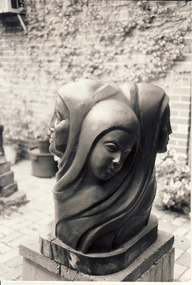
Photograph, Bronze Sculpture : Four Seasons, 1990
... can be found in the Kew Library and in the Alexandra Gardens ...The Austrian-born sculptor Leopoldine Mimovich was a prominent artist who lived and worked in Kew. Examples of her sculptures in Kew can be found in the Kew Library and in the Alexandra Gardens.Black and white photograph of sculpture or sculptures by Leopoldine Mimovich photographed in her home at 31 Miller Grove, Kewartists - kew (vic), leopoldine (poldi) mimovich -
 Kew Historical Society Inc
Photograph, Leopoldine Mimovich, Bronze Sculpture : Four Seasons, 1990
... and in the Alexandra Gardens. artists - kew (vic) leopoldine (poldi) mimovich ...Leopoldine Mimovich was born in 1920, in Neumarkt in the Italian Tyrol. In 1940, aged 20, she moved to Vienna where she studied clay modelling and drawing. From 1943 she attended the School of Wood Sculpture in Hallstatt, graduating in 1947. Following her marriage to Ljubisa Mimovich, the couple migrated to Australia in 1949 travelling on MV Skaugum. After an initial period at Bonegilla and Royal Park Migrant Hostels the couple moved to Yarraville and then to 33 Miller Road, Kew, where she established her studio. A wood sculptor, painter and etcher, she was awarded an OAM for services to the arts in 1985. Examples of her sculptures in Kew can be found in the Kew Library and in the Alexandra Gardens.Black and white photograph of sculpture or sculptures by Leopoldine Mimovich photographed in her home at 31 Miller Grove, Kewartists - kew (vic), leopoldine (poldi) mimovich -
 Kew Historical Society Inc
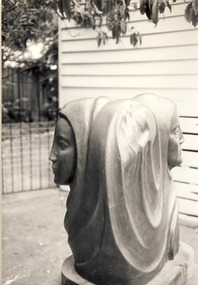
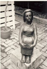
Photograph, Leopoldine Mimovich, Bronze Sculpture : Standing Woman, 1990
... and in the Alexandra Gardens. artists - kew (vic) leopoldine (poldi) mimovich ...Leopoldine Mimovich was born in 1920, in Neumarkt in the Italian Tyrol. In 1940, aged 20, she moved to Vienna where she studied clay modelling and drawing. From 1943 she attended the School of Wood Sculpture in Hallstatt, graduating in 1947. Following her marriage to Ljubisa Mimovich, the couple migrated to Australia in 1949 travelling on MV Skaugum. After an initial period at Bonegilla and Royal Park Migrant Hostels the couple moved to Yarraville and then to 33 Miller Road, Kew, where she established her studio. A wood sculptor, painter and etcher, she was awarded an OAM for services to the arts in 1985. Examples of her sculptures in Kew can be found in the Kew Library and in the Alexandra Gardens.Black and white photograph of sculpture or sculptures by Leopoldine Mimovich photographed in her home at 31 Miller Grove, Kewartists - kew (vic), leopoldine (poldi) mimovich -
 Kew Historical Society Inc
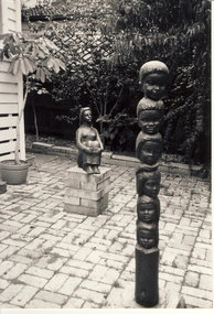
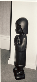
Photograph, Leopoldine Mimovich, Bronze Sculpture : Seated Woman & Totem Pole, 1990
... and in the Alexandra Gardens. artists - kew (vic) leopoldine (poldi) mimovich ...Leopoldine Mimovich was born in 1920, in Neumarkt in the Italian Tyrol. In 1940, aged 20, she moved to Vienna where she studied clay modelling and drawing. From 1943 she attended the School of Wood Sculpture in Hallstatt, graduating in 1947. Following her marriage to Ljubisa Mimovich, the couple migrated to Australia in 1949 travelling on MV Skaugum. After an initial period at Bonegilla and Royal Park Migrant Hostels the couple moved to Yarraville and then to 33 Miller Road, Kew, where she established her studio. A wood sculptor, painter and etcher, she was awarded an OAM for services to the arts in 1985. Examples of her sculptures in Kew can be found in the Kew Library and in the Alexandra Gardens.Black and white photograph of sculpture or sculptures by Leopoldine Mimovich photographed in her home at 31 Miller Grove, Kewartists - kew (vic), leopoldine (poldi) mimovich -
 Kew Historical Society Inc
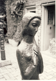
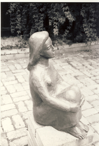
Photograph, Leopoldine Mimovich, Bronze Sculpture : Seated Woman, 1990
... and in the Alexandra Gardens. artists - kew (vic) leopoldine (poldi) mimovich ...Leopoldine Mimovich was born in 1920, in Neumarkt in the Italian Tyrol. In 1940, aged 20, she moved to Vienna where she studied clay modelling and drawing. From 1943 she attended the School of Wood Sculpture in Hallstatt, graduating in 1947. Following her marriage to Ljubisa Mimovich, the couple migrated to Australia in 1949 travelling on MV Skaugum. After an initial period at Bonegilla and Royal Park Migrant Hostels the couple moved to Yarraville and then to 33 Miller Road, Kew, where she established her studio. A wood sculptor, painter and etcher, she was awarded an OAM for services to the arts in 1985. Examples of her sculptures in Kew can be found in the Kew Library and in the Alexandra Gardens.Black and white photograph of sculpture or sculptures by Leopoldine Mimovich photographed in her home at 31 Miller Grove, Kewartists - kew (vic), leopoldine (poldi) mimovich -
 Kew Historical Society Inc
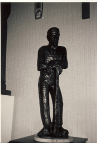
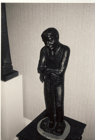
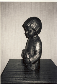
Photograph, Leopoldine Mimovich, Bronze Sculpture : The Worker, 1990
... and in the Alexandra Gardens. artists - kew (vic) leopoldine (poldi) mimovich ...Leopoldine Mimovich was born in 1920, in Neumarkt in the Italian Tyrol. In 1940, aged 20, she moved to Vienna where she studied clay modelling and drawing. From 1943 she attended the School of Wood Sculpture in Hallstatt, graduating in 1947. Following her marriage to Ljubisa Mimovich, the couple migrated to Australia in 1949 travelling on MV Skaugum. After an initial period at Bonegilla and Royal Park Migrant Hostels the couple moved to Yarraville and then to 33 Miller Road, Kew, where she established her studio. A wood sculptor, painter and etcher, she was awarded an OAM for services to the arts in 1985. Examples of her sculptures in Kew can be found in the Kew Library and in the Alexandra Gardens.Black and white photograph of sculpture or sculptures by Leopoldine Mimovich photographed in her home at 31 Miller Grove, Kewartists - kew (vic), leopoldine (poldi) mimovich -
 Kew Historical Society Inc
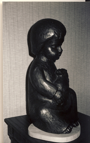
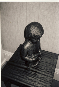
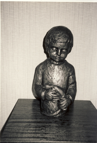
Photograph, Leopoldine Mimovich, Bronze Sculpture : Boy with Rabbit, 1990
... and in the Alexandra Gardens. artists - kew (vic) leopoldine (poldi) mimovich ...Leopoldine Mimovich was born in 1920, in Neumarkt in the Italian Tyrol. In 1940, aged 20, she moved to Vienna where she studied clay modelling and drawing. From 1943 she attended the School of Wood Sculpture in Hallstatt, graduating in 1947. Following her marriage to Ljubisa Mimovich, the couple migrated to Australia in 1949 travelling on MV Skaugum. After an initial period at Bonegilla and Royal Park Migrant Hostels the couple moved to Yarraville and then to 33 Miller Road, Kew, where she established her studio. A wood sculptor, painter and etcher, she was awarded an OAM for services to the arts in 1985. Examples of her sculptures in Kew can be found in the Kew Library and in the Alexandra Gardens.Black and white photograph of sculpture or sculptures by Leopoldine Mimovich photographed in her home at 31 Miller Grove, Kewartists - kew (vic), leopoldine (poldi) mimovich -
 Kew Historical Society Inc
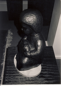
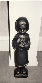
Photograph, Leopoldine Mimovich, Bronze Sculpture : Small Girl, 1990
... and in the Alexandra Gardens. artists - kew (vic) leopoldine (poldi) mimovich ...Leopoldine Mimovich was born in 1920, in Neumarkt in the Italian Tyrol. In 1940, aged 20, she moved to Vienna where she studied clay modelling and drawing. From 1943 she attended the School of Wood Sculpture in Hallstatt, graduating in 1947. Following her marriage to Ljubisa Mimovich, the couple migrated to Australia in 1949 travelling on MV Skaugum. After an initial period at Bonegilla and Royal Park Migrant Hostels the couple moved to Yarraville and then to 33 Miller Road, Kew, where she established her studio. A wood sculptor, painter and etcher, she was awarded an OAM for services to the arts in 1985. Examples of her sculptures in Kew can be found in the Kew Library and in the Alexandra Gardens.Black and white photograph of sculpture or sculptures by Leopoldine Mimovich photographed in her home at 31 Miller Grove, Kewartists - kew (vic), leopoldine (poldi) mimovich -
 Kew Historical Society Inc
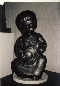
Photograph, Leopoldine Mimovich, Bronze Sculpture : Boy with Animal, 1990
... and in the Alexandra Gardens. artists - kew (vic) leopoldine (poldi) mimovich ...Leopoldine Mimovich was born in 1920, in Neumarkt in the Italian Tyrol. In 1940, aged 20, she moved to Vienna where she studied clay modelling and drawing. From 1943 she attended the School of Wood Sculpture in Hallstatt, graduating in 1947. Following her marriage to Ljubisa Mimovich, the couple migrated to Australia in 1949 travelling on MV Skaugum. After an initial period at Bonegilla and Royal Park Migrant Hostels the couple moved to Yarraville and then to 33 Miller Road, Kew, where she established her studio. A wood sculptor, painter and etcher, she was awarded an OAM for services to the arts in 1985. Examples of her sculptures in Kew can be found in the Kew Library and in the Alexandra Gardens.Black and white photograph of sculpture or sculptures by Leopoldine Mimovich photographed in her home at 31 Miller Grove, Kewartists - kew (vic), leopoldine (poldi) mimovich -
 Kew Historical Society Inc
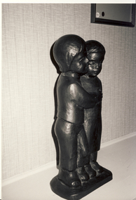
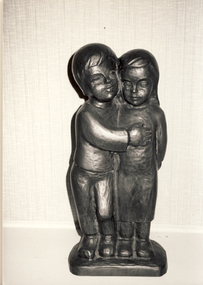
Photograph, Leopoldine Mimovich, Bronze Sculpture : Boy with Girl, 1990
... and in the Alexandra Gardens. artists - kew (vic) leopoldine (poldi) mimovich ...Leopoldine Mimovich was born in 1920, in Neumarkt in the Italian Tyrol. In 1940, aged 20, she moved to Vienna where she studied clay modelling and drawing. From 1943 she attended the School of Wood Sculpture in Hallstatt, graduating in 1947. Following her marriage to Ljubisa Mimovich, the couple migrated to Australia in 1949 travelling on MV Skaugum. After an initial period at Bonegilla and Royal Park Migrant Hostels the couple moved to Yarraville and then to 33 Miller Road, Kew, where she established her studio. A wood sculptor, painter and etcher, she was awarded an OAM for services to the arts in 1985. Examples of her sculptures in Kew can be found in the Kew Library and in the Alexandra Gardens.Black and white photograph of sculpture or sculptures by Leopoldine Mimovich photographed in her home at 31 Miller Grove, Kewartists - kew (vic), leopoldine (poldi) mimovich -
 Kew Historical Society Inc
Photograph, Leopoldine Mimovich, Bronze Sculpture : Boy with Girl, 1990
... and in the Alexandra Gardens. artists - kew (vic) leopoldine (poldi) mimovich ...Leopoldine Mimovich was born in 1920, in Neumarkt in the Italian Tyrol. In 1940, aged 20, she moved to Vienna where she studied clay modelling and drawing. From 1943 she attended the School of Wood Sculpture in Hallstatt, graduating in 1947. Following her marriage to Ljubisa Mimovich, the couple migrated to Australia in 1949 travelling on MV Skaugum. After an initial period at Bonegilla and Royal Park Migrant Hostels the couple moved to Yarraville and then to 33 Miller Road, Kew, where she established her studio. A wood sculptor, painter and etcher, she was awarded an OAM for services to the arts in 1985. Examples of her sculptures in Kew can be found in the Kew Library and in the Alexandra Gardens.Black and white photograph of sculpture or sculptures by Leopoldine Mimovich photographed in her home at 31 Miller Grove, Kewartists - kew (vic), leopoldine (poldi) mimovich -
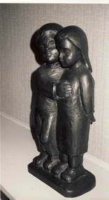 Kew Historical Society Inc
Photograph, Leopoldine Mimovich, Bronze Sculpture : Boy with Girl, 1990
... and in the Alexandra Gardens. artists - kew (vic) leopoldine (poldi) mimovich ...Leopoldine Mimovich was born in 1920, in Neumarkt in the Italian Tyrol. In 1940, aged 20, she moved to Vienna where she studied clay modelling and drawing. From 1943 she attended the School of Wood Sculpture in Hallstatt, graduating in 1947. Following her marriage to Ljubisa Mimovich, the couple migrated to Australia in 1949 travelling on MV Skaugum. After an initial period at Bonegilla and Royal Park Migrant Hostels the couple moved to Yarraville and then to 33 Miller Road, Kew, where she established her studio. A wood sculptor, painter and etcher, she was awarded an OAM for services to the arts in 1985. Examples of her sculptures in Kew can be found in the Kew Library and in the Alexandra Gardens.Black and white photograph of sculpture or sculptures by Leopoldine Mimovich photographed in her home at 31 Miller Grove, Kewartists - kew (vic), leopoldine (poldi) mimovich