Showing 1348 items matching " shelters"
-
 Lakes Entrance Historical Society
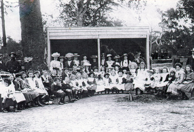
Photograph - Kalimna West School, Arthur Cooper, 1909 c
Black and white photograph large group of parents and children outside shelter shed at Kalimna West Primary School. Shows newly planted tree in front of group. Photo taken Arbor Day Picnic. Kalimna West Victoriaschools, students -
 Stawell Historical Society Inc
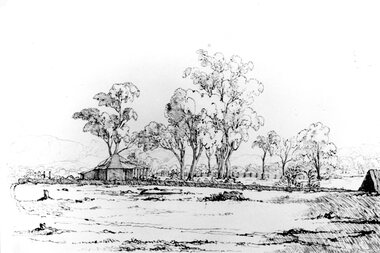
Photograph, "Moke-Billy" Station in the Grampians owned by Mr. Rose -- Sketch 1844 at National Gallery of Victoria
Copy of a sketch of Moke-Billy. Mr. Rose’s Station Grampians 1844 by R.H. Bunbury Previous to Mr. Rose, Charles Browning Hall early writing suggests Hall was a stock Herder this lead him to the Grampians district. Hall held two runs in the Wimmera district La Rose and Moke-Billy (Pille). 1841 - 42 - Hall's Gap is named after him. Phillip Davis Rose - Leased La Rose and Moke-Billy (Pille) 1842-43Original In National Gallery of VictoriaBlack & white photograph of a sketch of a log home and chimney. Lean-to on back, veranda on the front. Bark roof. Log fence. Building surrounded by tall trees with outline of mountains in the background. On the left is what looks like a back shelter. National Gallery of Victoria. Artist or School R. H. Bunbury 1814 - 1857 Title Moke-Billy, Mr. Rose's Station, Grampians. December, 1844. Medium drawing Dimensions 16.6 x 24.6 cm Accession No. Credit Line Presented 1954 To be reproduced only by written permission of National Gallery of Victoria 180 St. Kilda Road Melbourne Vic., Australia 3004. -
 Halls Gap & Grampians Historical Society
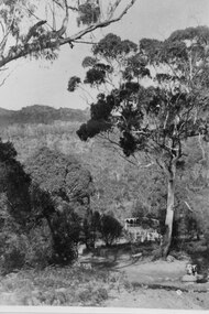
Photograph - B/W, C ?
This is the ford over the Stoney Creek and shelter shed.The photo shows a track leading down to a large pergola type structure, surrounded by thick bush. There is a tall gum on the right of the picture, beside the track. A large branch of a tree can be seen in the top left foreground.access routes, roads -
 Malmsbury Historical Society
Photograph (Item), Roadworks At Evans St Malmsbury C2000, Malmsbury c2000
Associated with - "Mhs, Mrsc?" Buildings - Bus Shelter -
 Stawell Historical Society Inc
Photograph, Deep Lead School and shelter shed 1947
Deep Lead School and shelter shed 1947stawell education -
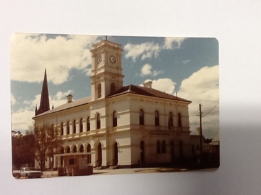
 Ballarat Tramway Museum
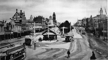
Photograph - Black & White Photograph/s, 1913
Yields information the streetscape at the bottom of Sturt St, near Grenville St, the ESCo shelter and how the trams used the track, though in this case, the same tram appears three times.Black and White copy photograph of a photograph of the Grenville tram terminus, in Sturt St, featuring the buildings on either side of Sturt St. Has the ESCo shelter at the bottom of the street, which dates from 1907 (Page 49 of "The Golden City and its tramways"). Note that a weighing machine appears to be on the north side of the shelter. The photograph features three trams, that appear to be the same tram, No. 5. It has a "Stop tram at Harry Davies" roof advertisement sign. Also features the "Sutton Pianos organs and music" sign. Also a number of people crossing the street.tramways, trams, sturt st, grenville st, bridge st, esco, tram 5 -
 Greensborough Historical Society
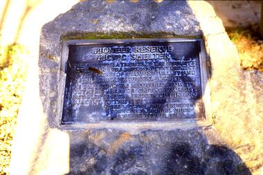
Slide - Photograph, John Ramsdale, Pioneer Reserve Picnic Shelter - Plaque: Slide 23, 1990s
Photograph shows Pioneer Reserve Picnic Shelter plaque.Part of the John Ramsdale collection of slides and audio visual material.Colour photograph scanned from slide.No maker's marks. No caption on slide.pioneer reserve greensborough, plaques -
 Flagstaff Hill Maritime Museum and Village
Photograph, March 1895
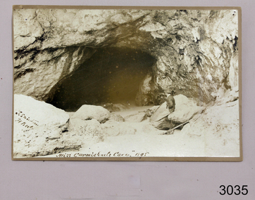
Loch Ard was bound for Melbourne in 1878 loaded with passengers and cargo when it ran into a rocky reef at the base of Mutton Bird Island, near Port Campbell. Of the 54 crew members and passengers on board, only two survived: an apprentice, Tom Pearce and a young woman passenger, Eva Carmichael, who lost all of her family in the tragedy. The wreck of Loch Ard still lies at the base of Mutton Bird Island and much of the cargo has been salvaged. Some was washed up into what is now known as Loch Ard Gorge following the shipwreck. Cargo and artefacts have also been illegally salvaged over many years before protective legislation was introduced. The photograph is significant for its association with the wreck of the Loch Ard. This wreck has been protected as a Historic Shipwreck since 11 March 1982, under the Commonwealth Historic Shipwrecks Act (1976) Flagstaff Hill’s collection of artefacts from Loch Ard is significant for being one of the largest collections of artefacts from this shipwreck in Victoria. It is significant for its association with the shipwreck, which is on the Victorian Heritage Register. The collection is significant because of the relationship between the objects, as together they have a high potential to interpret the story of the Loch Ard. The Loch Ard collection is archaeologically significant as the remains of a large international passenger and cargo ship. The Loch Ard collection is historically significant for representing aspects of Victoria’s shipping history and its potential to interpret sub-theme 1.5 of Victoria’s Framework of Historical Themes (living with natural processes). The collection is also historically significant for its association with the Loch Ard, which was one of the worst and best known shipwrecks in Victoria’s history. The Loch Ard collection meets the following criteria for assessment: Criterion A: Importance to the course, or pattern, of Victoria’s cultural history. Criterion B: Possession of uncommon, rare or endangered aspects of Victoria’s cultural history. Criterion C: Potential to yield information that will contribute to an understanding of Victoria’s cultural history. Photograph of Miss Eva Carmichaels Cave at Loch Ard Gorge where the survivors found shelter. Reverse has four areas of torn surface, perhaps were photo had been mounted. Hand written text in pencil and in ink.Reverse of photograph Hand written in pencil “ … refuge … which he … offer words … Miss Carmichael. He then … on the …“ Hand written in ink “Loch Ard Gorge / Miss Carmichael’s cave” and “ Mr J Swinton / Warrnambool / March 1895” flagstaff hill, warrnambool, shipwrecked coast, flagstaff hill maritime museum, maritime museum, shipwreck coast, flagstaff hill maritime village, great ocean road, loch line, loch ard, captain gibbs, eva carmichael, tom pearce, glenample station, mutton bird island, loch ard gorge, loch ard shipwreck, 1878 shipwreck, loch ard gorge, miss eva carmichael -
 Port of Echuca
Black and white photograph, Approx 1980
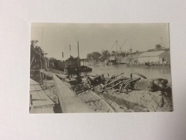
Scene depicted is believed to have been the Euston Lock. It shows various pieces of equipment in the foreground , with a pontoon names Bream on the left bank with a paddle steamer, sheds and cranes in the distance on the right hand side of the photograph. Original photograph from the Price collection. Historically and socially significant photograph depicting early 1920's life on the Murray river.Black and white photograph of river scene depicting , by the left bank a pontoon "Bream" and by the right bank a steamboat behind a shelter construction. There are various cranes on the right bank. Copy of an original photograph taken in the 1920s believed to at Euston Lock, N.S.W.In pencil on back: Price / believed to be Euston Lock.riverboats, paddle steamers, price collection -
 Bendigo Historical Society Inc.
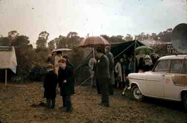
Slide - RALPH BIRRELL COLLECTION: EIG SCHOOL, c1966
EIG School - Ralph Birrell Collection. - Construction of Latrobe Uni. C1967. Bendigo Institute of Technology, Engineering School, Applied Science. - Construction of Latrobe Uni. C1967. People sheltering from the rain at speech time. Holden car to the right.Kodakeducation, tertiary, latrobe university bendigo, eig school - ralph birrell collection. - construction of latrobe uni. c1967. bendigo institute of technology, engineering school, applied science.. - construction of latrobe uni. c1967. bendigo institute of technology, engineering school, applied science. people sheltering from the rain at speech time. holden car -
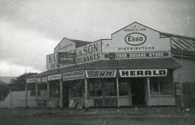 Lakes Entrance Historical Society
Photograph - Harbeck's Store, 1964c
Store was opened 1890c by Peter Harbeck, ancestor of the people standing at the front of the store. Photo taken after sale of the store in 1960's. In the photo are Mrs Northrope (Cross), Charlie Hancock, Tommy Harbeck, Eva Harbeck. Black and white photograph of Harbecks Store, Esplanade, showing old style general store. Built of weatherboard, with iron roof. Situated on the corner of Carpenter Street, a veranda with wooden floor shelters front and side of store. Lakes Entrance Victoriatownship, retail trade -
 Glen Eira Historical Society
Article - Tram Shelter, Balaclava Road
Caulfield Conservation study by Andrew Ward dated October 1994 on Tram Shelter, corner of Balaclava Road and Orrong Road with a brief history and a statement of significance from the National Trust of Australia. Four black and white photos of Balaclava Road tram shelter. National Trust classification report giving detail of shelter and others on the tramway routes of Melbourne. Includes history of cable car system and reasons for tramways amalgamations. It includes architectural features. Article from the Trust News, June 2000 on history of Melbourne Tram shelters, various architectural design and features and where they were built and who designed thembalaclava road, orrong road, tram shelters, street furniture, cast iron work, verandahs, edwardian style, the prahran and malvern tramways trust, ward andrew, historic buildings, dandenong road, caulfield north, glenhuntly road, green robert -
 Ballarat Tramway Museum
Slide - 27 mm sq slide/s - set of 9, Lilian Butler, View Point line:, 1971
... Shelters ...Yields information about the View Point line.Set of 8 Hanimex colour slides, white cardboard mount and one AGFA blue and white plastic mount slide of the View Point line: .1 - Point where the View Point line crossed from Ripon St to Wendouree Parade at Webster St. .2 - Trackwork arrangement at the intersection of Ripon St and Sturt St - shows blue stone paving around the tracks. .3 - Ballarat A Power Station - Wendouree Parade and Ripon St .4 - View Point track looking North near the boat sheds. .5 - View Point looking north to the Lake View Hotel, shows part of the View Point loop which has been removed. .6 - Trackwork arrangement at the intersection of Ripon and Sturt St, looking south with the Western Hotel in the view. Shows the shelter at the left hand side. .7 - View of the View Point Loop, with a warning on coming trams sign and the Hotel in the far distance. .8 - View of the curves at Mair and Ripon St. .9 - Looking north from the View Point terminus along Wendouree Parade. Photo from the collection of Lilian Butler. ballarat, tramways, trams, wendouree parade, ripon st, view point, ballarat a power station, sturt st, shelters, signs, mair st -
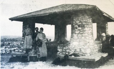 City of Ballarat Libraries
Photograph - Card Box Photographs, Black Hill Lookout, Ballarat 1924
People sit under stone shelter at the Black Hill Lookout.black hill lookout, building, people, public -
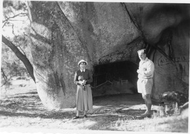 Stawell Historical Society Inc
Photograph, Stawell Field Naturalists at Bunjil's Shelter in the Black Range 1957
Stawell Field Naturalists – Bunjil's Shelter Black Range 1957stawell -
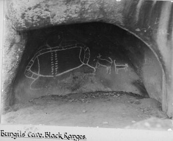 Stawell Historical Society Inc
Photograph, Bunjil’s Cave Aboriginal Rock shelter in the Black Ranges Stawell
Bunjil’s Cave Aborigional Rock shelter. Black Ranges Stawell.stawell aboriginal -
Glenelg Shire Council Cultural Collection
Photograph - Photograph - Vacuum Oil Co., Portland, n.d
Black and white photograph. Vacuum Oil Co Portland. Taken from elevated position. Fuel tanks, brick 3 bay shed, tower and pond, pumps and shelter, section of oval shaped lawn in centre. same premises as 8416, 8417Back: '89' in pencil. Round purple stamp 'Hunter's Same day service'portland harbour, industry -
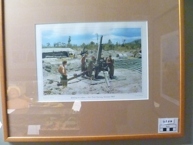 National Vietnam Veterans Museum (NVVM)
Photograph, Waiting For Orders
Colour photographic print in tan timber frame and musk coloured mat. Photograph depicts two field artillary weapons set up surrounded by sandbag perimeter.Personnel working on one of the guns. Background is bush, and a shelter with metal roof to left of picture.My Vietnam Collection Waiting for orders -105 Field Battery. Vietnam 1969 Copyright Jed Robinson.Gift Horse Gallery - Original works by local & interstate artists and crafts people.photograph, 105 field battery -
 Southern Sherbrooke Historical Society Inc.
Photograph - Menzies Creek Post Office, 1968
Photograph of Menzies Creek Post Office and General Store on the Belgrave-Gembrook Rd. Shows narrow flight of stairs to doorway. In front of store is a telephone box and a bus shelter, Many trees visible in background. Photo from National Archives of Australia. -
Port Melbourne Historical & Preservation Society
Audio - PMHPS Meeting, Dr Keith Pescod, "A place to lay my head", 22 Mar 2004
Recording of PMHPS Meeting on 22.03.2004. Recording done at Port Town Hall. Speaker was Dr Keith Pescod "A Place to lay my head". Discussing where migrants to melbourne found shelter in earliest days. Recording duration 01:02:25.immigration, dr keith pescod -
 Bendigo Historical Society Inc.
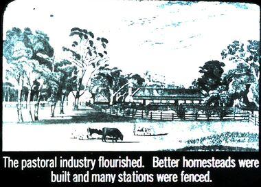
Slide - DIGGERS & MINING. THE GOLD ERA, c1850s
BHS CollectionDiggers & mining. The gold era. The pastoral industry flourished. Better homesteads were built and many stations were fenced. Slide shows some of the fencing and shelters added to homesteads. Markings 56 994.031 GOL:5. Used as a teaching aid.hanimounteducation, tertiary, goldfields -
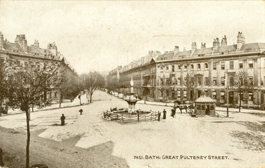 Federation University Historical Collection
Postcard - black and white, Great Pulteney Street, Bath
Great Pulteney Street is a grand thoroughfare that connects Bathwick on the east of the River Avon with the City of Bath, England via the Robert Adam designed Pulteney Bridge. Famous former residents of the street have included the novelist Jane Austen and the anti-slavery campaigner William Wilberforce.A black and white postcard showing Great Pulteney Street in Bath. The street is lined with triple storey building. A fountain and small shelter is located in the foreground.This card was purchased by an Australian soldier, probably Henry Smerdon Holmes, during World War One. chatham-holmes family collection, bath, gret pulteney street, fountain -
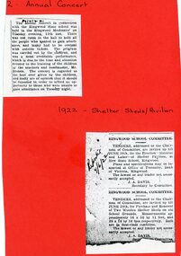 Ringwood and District Historical Society
Newspaper - Newspaper cuttings, Ringwood State School- Annual Concert, 1922. Shelter Sheds and Pavilion, 1922
Copy of cuttings from The Mail, 1922.Ringwood State School - Annual Concert held in the Ringwood Mechanics. 1922. - Tenders invited for erection of Pavilion at New State School. 1922. - Tenders invited for the Purchase and Removal of two Wooden Shelter Sheds on old School Grounds. 1922. -
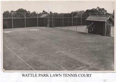 Melbourne Tram Museum
Photograph, Melbourne & Metropolitan Tramways Board (MMTB), "Wattle Park Lawn Tennis Court", c1950
The photograph shows the MMTB Wattle Park tennis courts with the seated shelter.Yields information about one of the facilities at Wattle Park that were provided by the MMTB.Black and white photograph with remnants of paper backing on the rear and an title sheet added to the bottom of the photograph.tramways, mmtb, wattle park, tennis -
 Port of Echuca
Colour photograph, Approx. 1979
The old Echuca Post Office was built circa 1877, a two-storey stucco building with a clock tower over the entrance, on the north east corner of Hare and Anstruther streets. In the front of the building is a small cream brick kiosk used as a bus stop and as a stall for charity group's to sell produce. On the far northern corner the spire of St.Mary's church can be seen above the roof of the Post Office.The old Echuca Post office is at the northern end of the shopping precinct in Hare street Echuca. The building is a beautiful grand building of the late 1870's which was built as a post office on the ground floor and a residence above. The small kiosk building in front of the post office was used by volunteer organisations to raise money selling cakes etc. at various times of the year.Colour photograph (post card size) of Echuca Post Office looking north. The post office was built circa 1877, a two storey building with a clock tower over the entrance door. In front of the building is a small cream brick kiosk and bus shelter.Printed on the reverse "this paper manufactured by Kodak"echuca post office, echuca-historical buildings -
Glenelg Shire Council Cultural Collection
Postcard - Postcard - Henty Beach, Portland, c. 1930
Black and white postcard. Rose series (Beach, Portland) Showing beach below the end of Gawler Street with people on beach, cars, shelters, swings, bathing boxes and other structures. Some hand colouring. Postcard under glass, to which it has adhered.Front: Back- 'Post (Sketch card of rose) The 'rose' series deluxe A real photograph produced in Australia - all printed -
Ringwood and District Historical Society
Newspaper - Clippings, Ringwood Mail, Several Cuttings from Ringwood 'Mail" 1996. *** Further details Required, 1996
Cuttings from'Mail' p.5 10-Dec-1996"Better times ahead for boys choir" p.5 19-Nov-1996 "In memory of Elizabeth" p 1 26-Mar-1996 "Dog Shelter Blow" +Additional Keywords: Membry, Elizabeth -
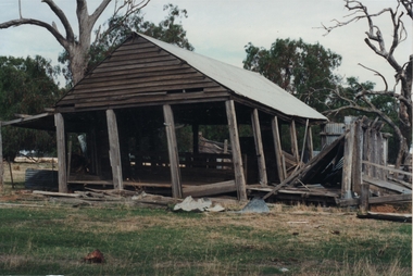 Bendigo Historical Society Inc.
Photograph - ROY J MITCHELL COLLECTION: FARM SHED NEAR GOORNONG
Colour photograph of farm shed, near Goornong. Shed is open shelter, has hand hewn uprights, corrugated iron roof. On back of photo:' 29.3.96 near Goornong, Vict, 14.30 hrs Shepparton Bendigo Road, by Roy J Mitchell, Bendigo.agriculture, farm, machinery -
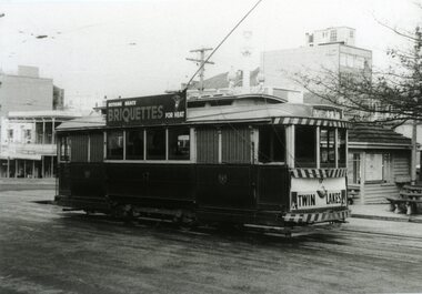 Ballarat Tramway Museum
Photograph - Black & White Photograph/s, John Murray, Jun. 1969
Black and white photograph of Ballarat 17 at the City Terminus, corner of Sturt and Lydiard Sts. Tram has the destination of Lydiard St., Twin Lakes on the rear dash and SEC "Briquettes" roof advertisement. Terminal shelter in the background. Photo by John Murray, c1969.On rear, written in black ink "SECV Ballarat No. 17 / c1969 / 18/22"tramways, trams, city terminus, sturt st, twin lakes, tram 17 -
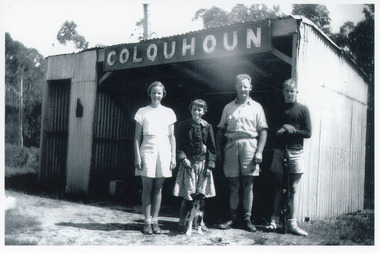 Lakes Entrance Historical Society
Photograph - Colquhoun Railway Siding, 1954
Standing on gravel platform are Jan, Alva, Dave and Ian Colquhoun and pup '?ussie'.Black and white photograph of four people and one pup at the Colquhoun railway siding. The railway shed is entirely clad in corrugated iron, comprising as open fronted shelter with a smaller room attached, partly enclosed. Sign COLQUHOUN on front. East Gippsland Victoriatransport, historic site