Showing 30340 items matching "boggy-creek-bridge-nowa-nowa"
-
 Falls Creek Historical Society
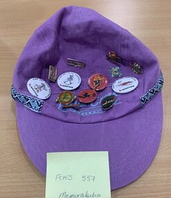
Clothing - Hat and Badges, Falls Creek Hat
Caps were a popular form of memorabilia for Falls Creek. The badges represents various Ski Clubs and Ski Schools. The badges on this cap include three Kids Ski Club Australia - Qantas Badges, two Falls Creek Ski Club Junior Racer badges and one Love Skiing Badge with the word love represented by a heart,. There are also seven other Falls Creek badges of various designs.This cap is representative of a range of memorabilia used to promote Falls Creek,Peak cap purple textile with geometric ribbon Falls Creek Australia in light blue 13 souvineer badgesFalls Creek AUSTRALIAfalls creek, ski school, qantas, badges, skiing -
 Ringwood and District Historical Society
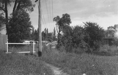
Photograph, Looking to Adelaide St. from Reynolds Ave. Ringwood (across Mullum Creek) 1973. Site of bridge washed away in floods 1931. Infant Welfare Centre (Dr. Hewitts) on right
Black and white photographCatalogue card reads, "Looking to Adelaide St. from Reynolds Ave. (across Mullum Creek) 1973. Site of bridge washed away in floods 1931. Infant Welfare Centre (Dr. Hewitts) on right." -
 Whitehorse Historical Society Inc.
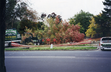
Photograph, Deep Creek Road, 1/04/2001 12:00:00 AM
Coloured photograph looking from Schwerkolt Cottage across Deep Creek Road to start of construction of new Bridge.deep creek road, mitcham -
 Whitehorse Historical Society Inc.
Photograph, Deep Creek Road, 1/04/2001 12:00:00 AM
Coloured photograph looking from footpath East side of Deep Creek Road at start of construction of new Bridge.deep creek road, mitcham -
 Eltham District Historical Society Inc
Photograph, Sketch of man on bridge over creek, 1971
Sketch of a man with a fishing pole standing on a bridge over a creek, stream or river in a bush setting. Unidentified artist and location.This photo forms part of a collection of photographs gathered by the Shire of Eltham for their centenary project book, "Pioneers and Painters: 100 years of the Shire of Eltham" by Alan Marshall (1971). The collection of over 500 images is held in partnership between Eltham District Historical Society and Yarra Plenty Regional Library (Eltham Library) and is now formally known as 'The Shire of Eltham Pioneers Photograph Collection.' It is significant in being the first community sourced collection representing the places and people of the Shire's first one hundred years.Digital imagesepp, shire of eltham pioneers photograph collection, fishing, creek, sketch, tranquil, unidentified, other areas, bush, outdoors, country life -
 Kew Historical Society Inc
Work on paper - Sepia Wash & Ink, G B Richardson, Creek and Old Watering Stage, on the Yarra, East Collingwood, 1854, 1854
Blind Creek was located between the Abbotsford Convent and what is now the Collins Bridge in Studley Park. In an 1858 map of East Collingwood by Clement Hodgkinson, in the State Library of Victoria, one can see how the creek was originally a significant landmark in Collingwood; remaining vacant land until a barrel drain enclosed it. The area was later filled in, surveyed and developed. The position where Blind Creek entered the Yarra was in the immediate vicinity of Hodgson’s Punt, which had linked Kew to the other side of the Yarra from 1839. The Punt was purchased by the Colonial Government in 1852 and was in use until the opening of the Studley Park Road (Johnston Street) Bridge in 1858 made its continued use redundantThe point of view selected by the artist for the watercolour is from the banks of Blind Creek in East Collingwood, looking across the Yarra to the Kew side of the river.Inscribed verso 'Creek and Old Watering stage, on the Yarra East Collingwood 1854 / Trees, stage, &c have long since disappeared / [Artist Signature] / FT 110 / Creek itself now being filled in 1903.gb richardson, blind creek - abbotsford, yarra river - abbotsford (vic) - kew (vic), colonial artists, australian art - 19th century, george bouchier richardson -
 Falls Creek Historical Society
Souvenir - Falls Creek Sticker
This item is from the private collection of George Shirling of Red Onion, Falls Creek. It is an early souvenir from Falls Creek Ski Village. George Shirling arrived in Falls Creek in 1962. He engaged Phil Nowell to build the original Koki Alpine Lodge which opened in 1965 with 14 beds. George operated the lodge with Michael “Baldy” Blackwell as manager. In 1981 he graduated in sport psychology and was invited to become team psychologist for the Australian Winter Olympic team which went to Albertville, France, in 1992. He later owned the Red Onion Chalet. George Shirling passed away on 27th February 2023. He had remained actively involved in Falls Creek and was generous with his time and knowledge, always an amazing supporter of The Falls Creek Museum and Falls Creek Village.This item is significant because it is representative of Falls Creek promotional material.A Falls Creek Sticker printed in black on a purple and white background and including the Falls Creek logo on the right hand end. SKI FALLS CREEK plus logo Come up and ski us sometime!george shirling, ski falls creek, falls creek souvenirs -
 Clunes Museum
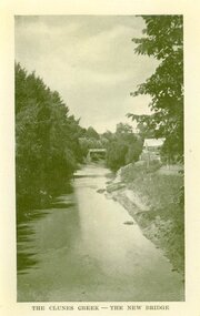
Photograph, AJAX SERIES
PRODUCED IN VICTORIACOPY OF PHOTOGRAPH OF CLUNES CREEK - BLUESTONE "GOVERNMENT" BRIDGE IN THE BACKGROUND, SMALL HUT ON RIGHT HAND BANK OF CREEK.THE CLUNES CREEK - THE NEW BRIDGElocal history, document, postcard, bridges -
 Beaufort Historical Society
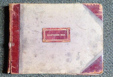
Work on paper (item) - Fiery Creek Lodge 157 VC Registration Book, Fiery Creek Masonic Lodge, Fiery Creek Lodge 157 VC Registration Book, 1890
Fiery Creek Masonic Lodge 157 VCProvides names and addresses and where relevant, date of decease.Registration Book, label front boardorganisations, clubs, beaufort - people, masonic lodges -
 Falls Creek Historical Society
Clothing - Falls Creek Souvenir Caps
These caps were donated by Blake Thompson who with his wife started skiing at Falls Creek in 1979 and were members of Aurora Lodge for many years. They wore these hats at Falls Creek and Cedarwood Lodge which had a bar in the 1990s and was seen as “the place to go.” Cedarwood was built about 1979 by Peter Hyndman. It was a large lodge with over 100 beds. Like many lodges it has now been renovated to become studio and self-contained apartments.These caps are significant because they are representative of the range of memorabilia available at Falls Creek.Two souvenir caps from Falls Creek and Cedarwood Lodge. The Falls Creek Cap is made from green tartan fabric with a green suede peak and the Falls Creek logo. The Cedarwood Lodge cap is made from blue corduroy fabric and features the multi-coloured Cedarwood Lodge logoCap1 - Below logo - FALLS CREEK Cap 2 - Cedar Wood LODGE / FALLS CREEK / AUSTRALIAfalls creek memorabilia, cedarwood lodge -
 Falls Creek Historical Society
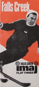
Booklet - imaj FLAT THREE Falls Creek
This brochure was published for the 1973 winter season. IMAJ Flat 3 is part of the IMAJ apartment complex in Falls Creek, Victoria. This brochure includes information about the Falls Creek area as well as a description of the accommodation and facilities in Flat 3. An insert includes a list of tariffs for Winter '73 and an inventory of items included at this accommodation.This Brochure is important because it documents a variety of accommodation in Falls Creek.An orange, black and white brochure advertising imaj Flat Three in Falls Creek. It has an image of a downhill skier on the front. When folded out, the brochure contains detailed information about facilities provided. An image of skiers and a map of Falls Creek is on the back.At top on front: Falls Creek Below skier: FALLS CREEK imaj FLAT THREEaccommodation falls creek, imaj apartments -
 Clunes Museum
Photograph
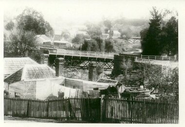
PHOTOGRAPH TAKEN LOOKING DOWNSTREAM TULLAROOP CREEK, ABOUT 1900. GOVERNMENT BRIDGE IN FOREGROUND, JULILEE BRIDGE IN MIDDLE DISTANCE, PORT PHILLIP MINE POPPET HED IN DISTANCE..1 ORIGINAL PHOTOGRAPH OF GOVERNMENT BRIDGE AND JUBILEE BRIDGE. TAKEN FROM CREEK PARADE. THE GOVERNMENT BRIDGE WAS BUILT CIRCA 1900. .2 ENLARGED PHOTOCOPY IN HANDWRITING : LOOKING DOWN-STREAM TULLAROOP CREEKABOUT 1900 GOVERMENT BRIDGE IN FOREGROUND JUBILEE BRIDGE IN THE MIDDLEbridges, jubilee bridge, goverment bridge -
 Lakes Entrance Historical Society
Book, Rule, Hilda, East Gippsland Past and Present, 1980
History of Nowa Now for the 'Back to Nowa Nowa' in September 1980. Includes photographs.township, timber industry, settlement -
 Greensborough Historical Society
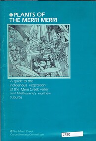
Book, Norman Anderson, Plants of the Merri Merri: a guide to the indigenous vegetation of the Merri Creek valley and Melbourne's northern suburbs, 1984
64 p., black & white illustrationsnon-fictionmerri creek, native flora -
 Greensborough Historical Society
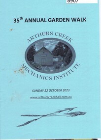
Booklet, Arthurs Creek Mechanics Institute, 35th Garden Walk, Arthurs Creek Mechanics Institute, 22/10/2023
Garden walk through various gardens in Arthurs Creek and surrounding areas. 12 page booklet, line drawings.arthurs creek mechanics institute, arthurs creek, doreen, diamond creek, hurstbridge -
 Eltham District Historical Society Inc
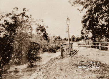
Photograph, Diamond Creek Bridge, Eltham North
Photograph copy of original showing the old Eltham North bridge upstream of present Wattletree Road bridgediamond creed, eltham north, wattletree road, coleman crescent, bridges -
 Phillip Island and District Historical Society Inc.
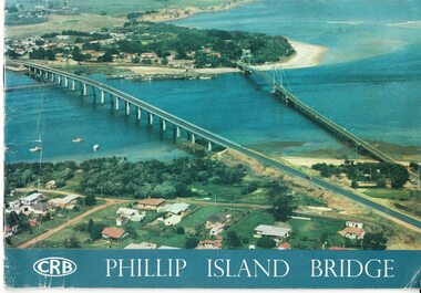
Booklet, Official Opening of the Phillip Island Bridge at San Remo 1969 and notes by the Bridge engineer, Tom Russell, 1969
Prior to 1939 access to the Island was by punt from San Remo or car ferry from Stony Point. A bridge was opened in 1940 but increased traffic and low load capacity was a problem. The decision to build a new bridge was made in the 1960s.HistoricalColoured, bound booklet with a photo of the old and new Phillip Island bridges on the cover and the CRB logo and name on rear. It includes the order of proceedings for the opening and bridge statistics, plans and contractor information. Also photos of construction and a history of travel to the Island before a bridge was built and the first bridge. There is also a 2 page typed document written by the bridge engineer who gives a brief history of access to the Island and problems at the opening with access and a rebel who tried to open it unofficially.Official Opening of the Phillip Island Bridge at San Remo by The Hon. M.V. Porter, MLA. Minister of Public Works. November 21 1969bridges, 2nd phillip island bridge construction, tom russell, phillip island bridge opening 1969 -
 Buninyong & District Historical Society
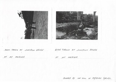
Photograph - Photocopy of two original B/W photographs, Mt Mercer Junction Bridge, photocopy made in 1995
Photos taken of the Junction Bridge at Mt Mercer, documenting the location, date unknown.The photos document the physical status of the location of the Junction Bridge at Mt Mercer at the time of photography, date unknown.Mt Mercer Junction Bridge. Photo 1 shows two men on the river bed probably looking at the bridge. Photo 2 shows Elsie Gibson sitting on the river bank with the bridge in the background.Photo 1. Photo taken at Junction Bridge at Mt Mercer. Photo 2. Elsie Gibson at Junction Bridge at Mt Mercer. Donated by Ian Hill of Hepburn Springsjunction bridge, mt mercer, bridge, elsie gibson, gibson, landscape -
 Narre Warren and District Family History Group
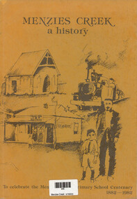
Book, R Hamilton et al, Menzies Creek : a history, 1982
Published in 1982 to celebrate the centenary of Menzies Creek Primary School (1882–1982). The book provides a detailed account of the history of Menzies Creek with illustrations, maps, and photographs, capturing the development of the area, including its gold mining origins, timber industry, and community milestones.Ochre cover with sketches depicting a church, train, general store and post office with a man and boy. Title at top of cover. Bottom of cover: To celebrate the Menzies Creek Primary School Centenary 1882-1982 64 p. : ill., facsims., maps, ports. ; 27 cm.non-fictionPublished in 1982 to celebrate the centenary of Menzies Creek Primary School (1882–1982). The book provides a detailed account of the history of Menzies Creek with illustrations, maps, and photographs, capturing the development of the area, including its gold mining origins, timber industry, and community milestones.menzies creek (vic.), menzies creek primary school (vic.) -
 Nillumbik Historical Society Incorporated
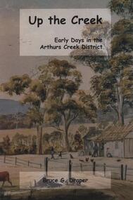
Book - Softcover book, BookPOD, Up The Creek Early Days in the Arthurs Creek District, 2018
A collation of reminiscences, anecdotes and recorded histories of the pioneer families and their descendants in Arthurs Creek, Victoria by Bruce Draper. From the back cover "Up the Creek is a window into the community spirit and achievements of former generations. This book is an enduring legacy to the families who were pivotal to the early settlement of Melbourne."Softcover book with a part of the painting "Arthurs Creek" by Harry Harwood (1878) wrapped around the front and back covers in green and blue tones, black lettering and 144 pages.#arthurscreek, #localhistory, #arthurscreekfamilies -
 Eltham District Historical Society Inc
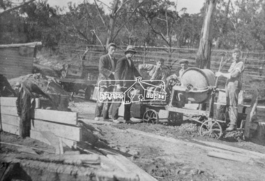
Photograph, Construction of the new concrete bridge over the Diamond Creek on Main Road, Eltham, c.May 1926
Construction of the new concrete bridge over the Diamond Creek on Main Road, Eltham, c.May 1926. Viewed from northern approach looking east, the access drive running off Antoinette Boulevard parallel to Main Road is visible as well as the power lines that used to run in front of Eltham Park (Eltham Lower Park). Also visible is a tree situated beside the roadway. It is believed this is the same tree that remains today as a dead tree trunk immediately adjacent to the road verge armco near the corner of Antoinette Boulevard. The original long suspension bridge over the Diamond Creek on Main Road at Eltham collapsed during flooding of the Diamond Creek on October 13 and 14, 1923. The original bridge was built around 1840 for the coach road when Cobb & Co.'s coach was the only conveyance between Eltham and Melbourne. Widespread damage was done in Melbourne and surrounding areas by floods resulting from the overflow of the Yarra at many points along its banks. A temporary bridge rigged up was severely damaged by the flooding of the creek and was closed to vehicular traffic in April 1924. A new concrete bridge was constructed to replace it and by May 1926 all the concrete piles and abutments had been completed. The bridge was finally completed and opened for traffic in September 1926, almost three years after it initially collapsed.This photo forms part of a collection of photographs gathered by the Shire of Eltham for their centenary project book,"Pioneers and Painters: 100 years of the Shire of Eltham" by Alan Marshall (1971). The collection of over 500 images is held in partnership between Eltham District Historical Society and Yarra Plenty Regional Library (Eltham Library) and is now formally known as the 'The Shire of Eltham Pioneers Photograph Collection.' It is significant in being the first community sourced collection representing the places and people of the Shire's first one hundred years.Photo print 9 x 12.5 cmshire of eltham pioneers photograph collection, eltham, bridge, diamond creek (creek), eltham south, main road bridge, wingrove park, antoinette boulevard, significant tree, cement mixer, bridge construction -
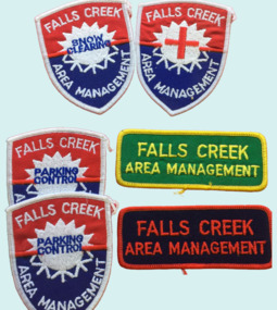 Falls Creek Historical Society
Badge - Falls Creek Area Management Cloth Badges
Falls Creek was operated by the Falls Creek Area Management Committee. Its composition changed over time but generally the Committee was composed of representatives of the State Electricity Commission, Representatives from Ski Clubs and commercial enterprises, the Country Roads Board, the Ski Tow company and a Representative of the Upper Murray Regional Committee of the Central Planning Authority. This Committee was responsibility for long term planning for the Falls Creek Tourist Area as well as the day to day running of the Village, These patches were part of the uniform of people employed by the Management Committee.These cloth badges are significant because they indicated employees of the Area Management Committee and the role they played in Falls Creek.A group of cloth badges indicating the role of personnel employed by the Falls Creek Area Management. Shield shaped badges - 2 Falls Creek Area Management - PARKING CONTROL 1 Falls Creek Area Management - with red cross of SKI PATROL Rectangular - Green and yellow - FALLS CREEK AREA MANAGEMENT Red and blue - FALLS CREEK AREA MANAGEMENTfalls creek village, falls creek area management committee -
 Whitehorse Historical Society Inc.
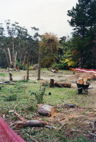
Photograph, Deep Creek Road, 1/04/2001 12:00:00 AM
Coloured photograph looking from Schwerkolt Cottage Reserve across Deep Creek Road as work begins on construction of new Bridge.deep creek road, mitcham -
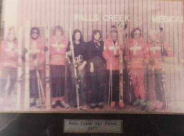 Falls Creek Historical Society
Photograph - Falls Creek Ski Patrol
The first ski patroller in Falls Creek was Brian Caddy with two casual ski patrollers Rob Sarroff and David Crooke in the 1960s. In 1972 the “official” Falls Creek Ski Patrol was created under the advisement of Dr Rodney Moss with the support of the Management Committee. By 1977 there were six or seven patrollers, and currently there are around 40 patrollers on the team with 13-14 rostered on each day during peak season. In 1974 the Australian Ski Patrol Association (ASPA) was formed. On the 14th March 1975, the Falls Creek Tourist Area Management Committee applied for membership to ASPA. At that time, Falls Creek Ski Patrol was known as Falls Creek Ski Rescue. From that time, Falls Creek patrollers began wearing the recommended uniform of a white cross on a red parka.This photo is significant because it depicts members of Falls Creek Ski Patrol, a vital service in the Falls Creek Tourist Area.A framed coloured photo of a group of Ski Patrollers in front of the Medical Centre, Falls Creek.Below image: Falls Creek Ski Patrol 1977falls creek ski patrol, falls creek, services falls creek -
 Victorian Interpretive Projects Inc.
Photograph - Colour, LJ Gervasoni, Nevins's Road, Yandoit Creek, 2004, 26/06/2004
The Gervasoni settled at Yandoit Creek in the 1860sDigital colour photograph of drystone buildings associated with the Gervasoni family at Yandoit Creek.ndoit, yandoit creek, yandoit hill, drystone, gervasoni -
Stawell Historical Society Inc
Archive - Books, Pleasant Creek Special School Pupil Register Transfer Notes & Register of Corporal Punishment, 1937
-1 Register 1937 - 1949 -2 Register 1949 - 1958 -3 Register 1958 - 1965 -4 Register 1965 - 1973 -5 Register 1972 - 1981 -6 Register 1981 - 1996 -7 Transfer Notes -8 Register of Corporal Punishment Former Pleasant Creek Hospital site. Sometimes referred to as Pleasant Creek Special School and sometimes Pleasant Creet Training Centre.Six large Registers printed by Government Printer Light Brown / Light Green in colour. Green Transfer Notes & Red Register of Corporal PunishmentSchool No 4549education -
![Studley Park [Toll] Bridge, Kew](/media/collectors/550653872162f11fb04854aa/items/579ebf04d0cdd117c4c0815f/item-media/579ebf3ad0cdd117c4c0953e/item-fit-380x285.jpg) Kew Historical Society Inc
Kew Historical Society IncPhotograph, Studley Park [Toll] Bridge, Kew, 1870s
‘Studley Park Bridge’ or ‘penny bridge’ linked Church Street in Abbotsford and what is now Yarra Bend Park. The privately constructed bridge opened in 1857, gaining its popular name from the toll charged at the Abbotsford end. The engineer of the 485ft wide bridge was Mr. Austin and the builder was ‘Mr Grant, who threw the bridge over the Niagara’. Following the opening of Johnston Street Bridge, declining tolls led to the Bridge falling into disrepair. Badly damaged by the flood of 1891, the Bridge was compulsorily acquired by the Government in 1899, and later dismantled and sold for firewood.This work forms part of the collection assembled by the historian Dorothy Rogers, that was donated to the Kew Historical Society by her son John Rogers in 2015. The manuscripts, photographs, maps, and documents were sourced by her from both family and local collections or produced as references for her print publications. Many were directly used by Rogers in writing ‘Lovely Old Homes of Kew’ (1961) and 'A History of Kew' (1973), or the numerous articles on local history that she produced for suburban newspapers. Most of the photographs in the collection include detailed annotations in her hand. The Rogers Collection provides a comprehensive insight into the working habits of a historian in the 1960s and 1970s. Together it forms the largest privately-donated collection within the archives of the Kew Historical Society.A print, taken in the 1960s by Dorothy Rogers, from an original albumen silver photograph now in the collection of the Kew Historical Society. The photograph shows the toll bridge (also known as the Penny Bridge) from the northern end."P[enny] Toll Bridge - built 1857. from old photo"studley park bridge, penny bridge, bridge, timber bridge, toll bridge -
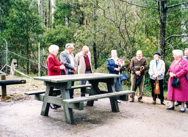 Eltham District Historical Society Inc
Photograph, Dedication of picnic table at Wilks Creek Bridge, Marysville by Marysville Historical Society, 13 October 1993, 13/10/1993
Wilks Creek Bridge was built in 1870. It was last used for heavy vehicle traffic in 1980 and left to decay until it was demolished in 2008. The last remnants of the timber structure were destroyed in the Black Saturday bushfire of 7 February 2009. [from EDHS Newsletter No. 93, November 1993:] OTHER NEWS A small group of members represented the Society at the opening of the picnic ground at the historic Wilks Creek Bridge at Marysville. The event included the launching of a booklet by our friend Ann Thomas on the history of the bridge which was located on the old Yarra Track coaching route between Eltham and Woods Point. Ann has donated a copy of the booklet to our Society.Two colour photographsactivities, marysville, wilks creek bridge -
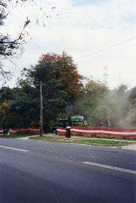 Whitehorse Historical Society Inc.
Photograph, Deep Creek Road, 1/04/2001 12:00:00 AM
Coloured photograph looking from Schwerkolt Cottage Reserve across Deep Creek Road as trees are cut down for construction of new Bridge.deep creek road, mitcham, vicroads -
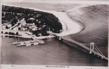 Phillip Island and District Historical Society Inc.
Photograph, Phillip Island Bridge, 1940
The bridge built around 1939. Fishing fleet. Twin jetties to left of bridge, township, bush and wide sand strip of surf beach.Bridge between Phillip Island and San Remo. Photograph depicting San Remo onlyNo. 1. Phillip Island Bridge, Vic. Airspy Photolocal history, photographs, bridges, san remo, coastline, bridge, fishing fleet, jetties, bruce bennett