Showing 930 items
matching bridge building
-
 4th/19th Prince of Wales's Light Horse Regiment Unit History Room
Poem, The Horses Stay Behind, 1919
During WW1 Australia sent 39,348 Walers overseas to the AIF. Many Light Horsemen enlisted with their horses with a government promise that they would be able to bring their horses home with them. On the outbreak of peace, costs became important and it was deemed too costly to have horses repatriated to Australia - except for one horse, "Sandy", owned by General W T Bridges who died at Gallipoli in 1915 Quarantine was offered as a reason for not permitting the walers to return to Australia. However, the horses would have had a long sea voyage, giving time for problems to emerge. Many of the fit horses were sold to the Indian ArmyFramed print of poem "The Horses Stay behind". In days to come we'll wander west and cross the range again; We'll hear the bush birds singing in the green trees after rain; We'll canter through the Mitchell grass and breast the bracing wind: But we'll have other horses. Our chargers stay behind. Around the fire at night we'll yarn about old Sinai; We'll fight our battles o'er again; and as the days go by There'll be old mates to greet us. The bush girls will be kind. Still our thoughts will often wander to the horses left. I don't think I could stand the thought of my old fancy hack Just crawling round old Cairo with a Gyppo on his back. Perhaps some English tourist out in Palestine may find My broken-hearted waler with a wooden plough behind. No; I'd better shoot him and tell a little lie: "He floundered in a wombat hole and then lay down to die" May be I'll be court-martialled; but I'm damned if I'm inclined To go back to Australia and leave my horse behind. Trooper Bluegum -
 Flagstaff Hill Maritime Museum and Village
Document - Map, Department of Lands & Survey, Victoria / Panmure, 1942
This Emergency Edition of the map of Panmure, Victoria, is part of the W.R. Angus Collection. It was printed in 1942 during World War II. It is one of two maps donated to Flagstaff Hill Maritime Village by the family of Doctor William Roy Angus, who served as Surgeon Captain in the Australian Defence Department. The map was compiled for the Dept. of Army by the Dept. of Lands and Survey in Melbourne, prepared by the Australian Section of the Imperial General Staff, which was a British Government body created in 1907 to co-ordinate the defence of Britain and its Empire. It was printed by A.H.Q. Cartographic Company, Survey Corps, which was formed in 1941. The Corp changed its name to L.H.Q. Cartographic Company of Bendigo. In 1947 the name reverted back to the A.H.Q. Cartographic Company until 1955 when it became the A.H.Q. Survey Regiment. The W.R. Angus Collection includes historical medical equipment, surgical instruments and material once belonging to Dr Edward Ryan and Dr Thomas Francis Ryan, (both of Nhill, Victoria) as well as Dr Angus’ own belongings. The Collection’s history spans the medical practices of the two Doctors Ryan, from 1885-1926 plus that of Dr Angus who began practice in 1924. Dr. Angus served with the Australian Department of Defence as a Surgeon Captain during the Second World Was from 1942 to 1945. He served in Ballarat, Victoria, and in Bonegilla, N.S.W. until he suffering from a heart attack just before the war ended. ABOUT THE “W.R.ANGUS COLLECTION” - Doctor William Roy Angus M.B., B.S., Adel., 1923, F.R.C.S. Edin.,1928, was generally known as Dr Roy Angus. His working life included a position as a doctor with the Flying Doctor Service in Australia’s rural and remote areas. After many varied experiences Dr Angus and his family moved to Warrnambool in 1939 where he purchased “Birchwood,” the 1852 home and medical practice of Dr John Hunter Henderson. He was appointed on a part-time basis as Port Medical Officer in Warrnambool and held this position until the 1940’s when the government no longer required the service of a Port Medical Officer. Dr Angus was a surgeon at the Warrnambool Base Hospital 1939-1942. After further studies he commenced practice as an ophthalmologist in Warrnambool, pioneering in artificial eye improvements. He was Honorary Consultant Ophthalmologist to Warrnambool Base Hospital for 31 years and made monthly visits to Portland to perform eye surgery. Dr Angus and his wife Gladys were very involved in Warrnambool’s community with a strong interest in civic affairs. They were both involved in the creation of Flagstaff Hill Maritime Village, including the layout of the gardens. After his death on 28th March 1970 his family requested his practitioner’s plate, medical instruments and some personal belongings be displayed in the Port Medical Office surgery at Flagstaff Hill Maritime Village, and be called the “W. R. Angus Collection”. This Emergency Edition of the Map of Panmure is significant as an example of the documents prepared for the defence of Australia in World War 2. The Map is also significant for its connection between the Australian Army and the involvement of Dr WR Angus as a Surgeon in the Medical Services during World War II. The W.R. Angus Collection is significant for still being located at the site it is connected with, Doctor Angus being the last Port Medical Officer in Warrnambool. The collection of medical instruments and other equipment is culturally significant, being an historical example of medicine, administration, household equipment and clothing from late 19th to mid-20th century. Dr Angus assisted Dr Tom Ryan, a pioneer in the use of X-rays and in ocular surgery. The collection includes Dr Angus’s Army objects and is significant as an example of items issued to Doctors and Surgeons in the Medical Services of the Australian Army in World War IIMilitary map of Panmure, Victoria, Australia; part of the W.R. Angus Collection. Rectangular coloured map on cream paper for the Australian Army. Details include sea, waterways and land, contour lines, grid lines, names of districts, towns and roads, bridges, swamps, rail lines, cuttings, tracks, buildings (including blacksmiths), pumps, lighthouses, telegraph, telephones and electric transmission lines, and fire stations. The map has margin notes that include distances in miles to nearby towns. The map was compiled for the Dept. of Army by the Dept. of Lands and Survey in Melbourne, prepared by the Australian Section, Imperial General Staff and printed by A.H.Q. Cartographic Company, Melbourne in 1942. Crown Copyright Reserved. Inscriptions in red print state that it is and Emergency Edition and an Official document. An oval purple stamp includes the price.Printed in black; 'Victoria / Panmure", "No. 930 / Zone 6" Printed in red; “EMERGENCY EDITION”, “THIS MAP IS AN OFFICIAL DOCUMENT. IF FOUND, IT MUST BE HANDED / IN TO THE NEAREST MILITARY HEADQUARTERS OR POLICE STATION” Stamped: within concentric ovals (“- - - FOR SALE / PRICE 2/- / - - - - - OF THE ARMY”)flagstaff hill, warrnambool, flagstaff hill maritime museum, maritime museum, shipwreck coast, flagstaff hill maritime village, great ocean road, dr w r angus, dr ryan, warrnambool base hospital, flying doctor, surgeon captain, australian department of defence, royal australian army, world war 2, map panmure 1942, roy angus, port medical officer, nhill base hospital, military map, emergency map, military service australian army, department of army, department of lands and survey, a.h.q. cartographic company melbourne, panmure 1942, australian section, imperial general staff -
 Flagstaff Hill Maritime Museum and Village
Document - Map, Department of Lands & Survey, Victoria / Port Campbell, 1942
This Emergency Edition of the map of Port Campbell, Victoria, is part of the W.R. Angus Collection. It was printed in 1942 during World War II. It is one of two maps donated to Flagstaff Hill Maritime Village by the family of Doctor William Roy Angus, who served as Surgeon Captain in the Australian Defence Department. The map was compiled for the Dept. of Army by the Dept. of Lands and Survey in Melbourne, prepared by the Australian Section of the Imperial General Staff, which was a British Government body created in 1907 to co-ordinate the defence of Britain and its Empire. It was printed by A.H.Q. Cartographic Company, Survey Corps, which was formed in 1941. The Corp changed its name to L.H.Q. Cartographic Company of Bendigo. In 1947 the name reverted back to the A.H.Q. Cartographic Company until 1955 when it became the A.H.Q. Survey Regiment. The W.R. Angus Collection includes historical medical equipment, surgical instruments and material once belonging to Dr Edward Ryan and Dr Thomas Francis Ryan, (both of Nhill, Victoria) as well as Dr Angus’ own belongings. The Collection’s history spans the medical practices of the two Doctors Ryan, from 1885-1926 plus that of Dr Angus who began practice in 1924. Dr Angus served with the Australian Department of Defence as a Surgeon Captain during the Second World Was from 1942 to 1945. He served in Ballarat, Victoria, and in Bonegilla, N.S.W. until he suffering from a heart attack just before the war ended. ABOUT THE “W.R.ANGUS COLLECTION” - Doctor William Roy Angus M.B., B.S., Adel., 1923, F.R.C.S. Edin.,1928, was generally known as Dr Roy Angus. His working life included a position as a doctor with the Flying Doctor Service in Australia’s rural and remote areas. After many varied experiences Dr Angus and his family moved to Warrnambool in 1939 where he purchased “Birchwood,” the 1852 home and medical practice of Dr John Hunter Henderson. He was appointed on a part-time basis as Port Medical Officer in Warrnambool and held this position until the 1940’s when the government no longer required the service of a Port Medical Officer. Dr Angus was a surgeon at the Warrnambool Base Hospital 1939-1942. After further studies he commenced practice as an ophthalmologist in Warrnambool, pioneering in artificial eye improvements. He was Honorary Consultant Ophthalmologist to Warrnambool Base Hospital for 31 years and made monthly visits to Portland to perform eye surgery. Dr Angus and his wife Gladys were very involved in Warrnambool’s community with a strong interest in civic affairs. They were both involved in the creation of Flagstaff Hill Maritime Village, including the layout of the gardens. After his death on 28th March 1970 his family requested his practitioner’s plate, medical instruments and some personal belongings be displayed in the Port Medical Office surgery at Flagstaff Hill Maritime Village, and be called the “W. R. Angus Collection”. This Emergency Edition of the Map of Port Campbell is significant as an example of the documents prepared for the defence of Australia in World War 2. The Map is also significant for its connection between the Australian Army and the involvement of Dr WR Angus as a Surgeon in the Medical Services during World War II. The W.R. Angus Collection is significant for still being located at the site it is connected with, Doctor Angus being the last Port Medical Officer in Warrnambool. The collection of medical instruments and other equipment is culturally significant, being an historical example of medicine, administration, household equipment and clothing from late 19th to mid-20th century. Dr Angus assisted Dr Tom Ryan, a pioneer in the use of X-rays and in ocular surgery. The collection includes Dr Angus’s Army objects and is significant as an example of items issued to Doctors and Surgeons in the Medical Services of the Australian Army in World War IIMilitary map of Port Campbell, Victoria, Australia; part of the W.R. Angus Collection. Rectangular coloured map on cream paper for the Australian Army. Details include sea, waterways and land, contour lines, grid lines, names of districts, towns and roads, bridges, swamps, rail lines, cuttings, tracks, buildings (including blacksmiths), pumps, lighthouses, telegraph, telephones and electric transmission lines, and fire stations. The map has margin notes that include distances in miles to nearby towns. The map was compiled for the Dept. of Army by the Dept. of Lands and Survey in Melbourne, prepared by the Australian Section, Imperial General Staff and printed by A.H.Q. Cartographic Company, Melbourne in 1942. Crown Copyright Reserved. Inscriptions in red print state that it is and Emergency Edition and an Official document. An oval purple stamp includes the price.Printed in black; 'Victoria / Port Campbell", "No. 932 / Zone 6" Printed in red; “EMERGENCY EDITION”, “THIS MAP IS AN OFFICIAL DOCUMENT. IF FOUND, IT MUST BE HANDED / IN TO THE NEAREST MILITARY HEADQUARTERS OR POLICE STATION” Stamped: within concentric ovals (“- - - FOR SALE / PRICE 2/- / - - - - - OF THE ARMY”)flagstaff hill, warrnambool, flagstaff hill maritime museum, maritime museum, shipwreck coast, flagstaff hill maritime village, great ocean road, dr w r angus, dr ryan, warrnambool base hospital, nhill base hospital, flying doctor, surgeon captain, map port campbell 1942, roy angus, port medical officer, military map, emergency map, australian department of defence, royal australian army, military service australian army, department of army, department of lands and survey, world war 2, a.h.q. cartographic company melbourne, australian section, imperial general staff, port campbell 1942 -
 Phillip Island and District Historical Society Inc.
Photographs, 1940's to 1960's
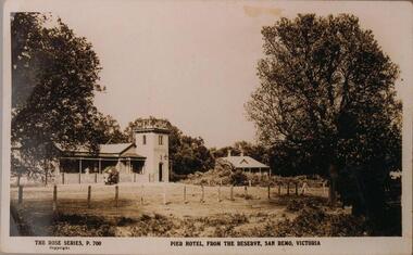
Part of a collection of photographs donated by Bruce Bennett. Photographs from collections of: David Johnson, I Mannix, Legg, Charlie Blackney, Des Chilcott, Ted Walton, Len Bagley and Brian Davis.233-20. Black & White photograph of a postcard. The Pier Hotel and house set in paddock and surrounded by large trees and reserve at San Remo, Victoria. 233-21. Black & White photograph of a photograph. Bentons Guesthouse, San Remo, Victoria. 233-22. Black & White photograph of a photograph. Herbie Kirkland or Clive Fox?? on barge at Newhaven, showing cray caufs lined up on jetty in the background. 233-23. Black & White photograph of a photograph. San Remo Hotel. 233-24. Black & White photograph of a photograph. Breakwater at San Remo circa 1940 with family on the beach (Bert Blackney & Violet) and people swimming. Wooden groyne in foreground. 233-25. Black & White photograph of a photograph. Building the slip at Newhaven, Phillip Island. 233-26. Black & White photograph of a photograph. House in the distance at Rhyll built by Johnson. Dan Patience lived there till 1950's then Ted Walton. 233-27. Black & White photograph of a photograph. San Remo to Newhaven, Phillip Island punt with 3 cars on board. 233-28. Black & White photograph of a photograph. San Remo jetty showing boats and sheds. Ivan Hayhow boat. 233-29. Black & White photograph of a photograph. Sailing boat on Westernport with Phillip Island Suspension bridge behind.233-20 The Rose Series P700. Pier Hotel, from the reserve, San Remo, Victoriahotels, pier hotel san remo victoria, san remo hotel victoria, bentons guesthouse san remo, guesthouses, san remo to newhaven barge, phillip island barge, newhaven barge, san remo beach, newhaven slip phillip island, rhyll phillip island, san remo punt, san remo jetty, phillip island suspension bridge, sailing boats, bruce bennett -
 Phillip Island and District Historical Society Inc.
Newspaper clippings, 07/10/1948
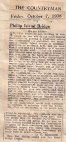
... Letter to The Countryman newspaper urging building... urging building of a bridge connecting Phillip Island ...Letter in The Countryman newspaperLetter to The Countryman newspaper urging building of a bridge connecting Phillip Island and The Mainland.local history, documents, newspapers, bridges, phillip island, black & white newspaper clipping -
 Greensborough Historical Society
Photograph - Digital Image, Bridge Inn Hotel Mernda 2018, 25/07/2019
In 2018 GHS members visited Turner's Bakery in Mernda for lunch and continued on to visit historic sites remaining in the Mernda area. This photograph shows the Bridge Inn Hotel Mernda, established 1891. The hotel is still operating in the 21st century.Mernda is an area of rapid modern growth with a few remaining historic buildings dating from the 19th century.Digital copy of colour photographmernda, bridge inn hotel mernda, mernda historic sites, hotels mernda -
 Greensborough Historical Society
Photograph - Digital Image, Marilyn Smith, Mernda Mechanics Institute 2018, 27/09/2018
In 2018 GHS members visited Turner's Bakery in Mernda for lunch and continued on to visit historic sites remaining in the Mernda area. This photograph shows the Mernda Mechanics Institute, established 1888. It was sited to the rear of the Bridge Inn Hotel on land donated by the hotel's owner. Today the Mechanic's institute is a small hall available to rent.Mernda is an area of rapid modern growth with a few remaining historic buildings dating from the 19th century.Digital copy of colour photographsmernda, mernda historic sites, mernda mechanics institute, mechanics institutes victoria, bridge inn hotel mernda -
 Greensborough Historical Society
Photograph - Digital Image, Marilyn Smith, Mernda Station 2018, 27/09/2018
In 2018 GHS members visited Turner's Bakery in Mernda for lunch and continued on to visit historic sites remaining in the Mernda area. This photograph shows the newly built Mernda Station, part of the railway extension on the old Epping line. This station was opened in August 2018. Mernda is now the end of the line. It is sited on corner Bridge Inn Road and Schotters Road. Mernda is an area of rapid modern growth with a few remaining historic buildings dating from the 19th century.Digital copy of colour photographmernda, mernda historic sites, schotters road mernda, mernda station, bridge inn road mernda -
 Greensborough Historical Society
Photograph - Digital Image, Marilyn Smith, Old Mernda Market 2018, 27/09/2018
In 2018 GHS members visited Turner's Bakery in Mernda for lunch and continued on to visit historic sites remaining in the Mernda area. This photograph shows remnants of the Mernda Market, established in 1919 as a livestock market. It was sited on Plenty Road in the carpark of the Bridge Inn Hotel. It evolved into a weekend 'trash and treasure' market although livestock auctions still took place on Mondays. In 2012 the livestock auctions moved to Whittlesea Showgrounds.Mernda is an area of rapid modern growth with a few remaining historic buildings dating from the 19th century.Digital copy of colour photographsmernda, mernda historic sites, mernda market, plenty road mernda, livestock auctions, trash and treasure markets -
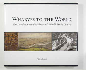 Mission to Seafarers Victoria
Book, Melbourne Books, Wharves To The World: The Development Of Melbourne's World Trade Centre, 2011
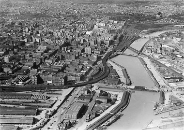
Wharves to the World: The Development of Melbourne's World Trade Centre is a photographic chronicle of the history of the World Trade Centre and its surrounds. The book traces the journey of land and the buildings that occupied it - from its beginnings with the Wurundjeri people to its role as a trading hub in early Melbourne, then as the site of the modern-day World Trade Centre, and now as part of a flourishing residential and commercial Precinct. As with any major project The World Trade Centre has face its share of fêlures, but despite thèse it has become an integral part of the City. So it goes that was once home to swampland and the City morgue has been transformer into a Diamond of the Yarra River.A 128-page book of printed matter, photographs, engravings and drawings. The hard cover is white with the title in gold lettering on the front. The dust-cover is also white with black lettering. Along the lower half of the cover, front and back, is a strip of six photos, three coloured and three black and white. 128 p. : ill. (some col.), ports. ; 22 x 25 cm.non-fictionWharves to the World: The Development of Melbourne's World Trade Centre is a photographic chronicle of the history of the World Trade Centre and its surrounds. The book traces the journey of land and the buildings that occupied it - from its beginnings with the Wurundjeri people to its role as a trading hub in early Melbourne, then as the site of the modern-day World Trade Centre, and now as part of a flourishing residential and commercial Precinct. As with any major project The World Trade Centre has face its share of fêlures, but despite thèse it has become an integral part of the City. So it goes that was once home to swampland and the City morgue has been transformer into a Diamond of the Yarra River.yarra yarra tribe, early melbourne, world trade centre, melbourne, southbank, northbank, australian wharf, siddeley street, waterfront, amy zurrer, wurundjeri, spencer street bridge, north wharf, riverlee, wtc, wharf, harbor trust, sir john coode, harbour trust, little dock, polly woodside, wharfies, divers -
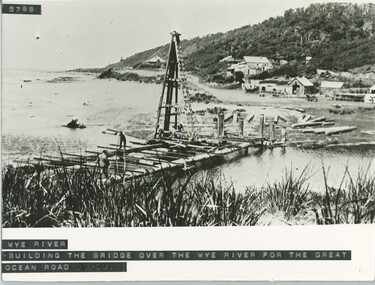 Lorne Historical Society
Photograph, Building of the bridge at Wye River, on G.O.R
... Building of the bridge at Wye River, on G.O.R... River on the G.O.R. Building of the bridge at Wye River ...Photograph showing construction of the bridge at Wye River on the G.O.R.g.o.r; wye-river; g.o.r; bridge-construction; -
 Mission to Seafarers Victoria
Photograph - Digital photograph, Black and white, Charles Daniel Pratt (1892-1968), c. 1927
The tennis court was built in 1924, after a suggestion from seamen. It was used until the 50s when it was too damaged and costly to keep. The Hawthorn branch of the LHLG raised the funds. Aerial photograph of the Yarra river depicting the Siddeley and Flinders buildings with the tennis court.tennis court, sports, charles daniel pratt (1892-1968), fishmarket, spencer street bridge, sailors' home, siddeley street, flinders street, mission to seafarers, seamen's mission, seamen's institute -
 Phillip Island and District Historical Society Inc.
Newspaper Clippings, 27/07/1967
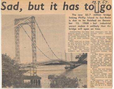
... building of new bridge...Newspaper article concerning the building of new bridge... in scrap book dated 1960 - 1973 local history newspapers building ...Collection of newspaper clippers in scrap book dated 1960 - 1973Newspaper article concerning the building of new bridge Phillip Island - San Remo; expected completion date; industrial dispute; photograph of old bridge"Sad, but it had to go"local history, newspapers, building of new bridge, phillip island - san remo 1967, jean jamieson -
 Phillip Island and District Historical Society Inc.
Newspaper clippings, 04/07/1967
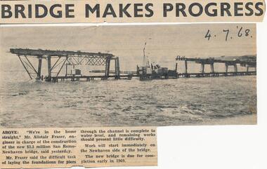
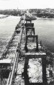
... Newspaper article concerning the building of new bridge... progress" Newspaper article concerning the building of new bridge ...Collection of newspaper clippers in scrap book dated 1960 - 1973Newspaper article concerning the building of new bridge Phillip Island - San Remo; foundations laid in channel; photograph of bridge in construction."Bridge makes progress"local history, newspapers, jean jamieson, phillip island new bridge from san remo -
 Phillip Island and District Historical Society Inc.
Photograph, 1978/9
... the bridge to Phillip Island. local history photographs buildings ...In 1940 Churchill Island was bought by Dr Edward Henry Jenkins - a Melbourne Dentist, who built the bridge to Phillip Island.Coloured photograph showing the bridge from Churchill Island to Phillip Islandlocal history, photographs, buildings - historical, rural industry, bridges, coloured photograph, john cook, churchill island -
Phillip Island and District Historical Society Inc.
Newspaper clippings
Newspaper clipping on early history of San Remo and district, the naming of the township, San Remo Heights Estate Hall and the San Remo Post Office.Early history of San Remo, including its original settlement, surveying of the district, change of name from Griffiths Point proclaimed in the Victorian Government Gazette on 11th august, 1888. also early history of San Remo Heights Estate Hall and the San Remo Post Office. Includes a photograph of the township and fishing fleet probably taken from 1940 bridge.local history, documents, newspapers, san remo, buildings - historical, black & white newspaper clipping, san remo, post office, fishing fleet -
 Phillip Island and District Historical Society Inc.
Photograph, Phillip Island Bridge, 1968/9
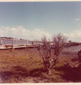
... Building of second Bridge under construction between San... collection public construction Building of second Bridge under ...The 2nd Bridge under construction which replaced the Suspension Bridge built in 1940. From the Jack Jenner Collection.Building of second Bridge under construction between San Remo and Newhaven.local history, photographs, civil engineering, bridges, phillip island bridges, black & white photograph, jack jenner collection, public construction -
 Greensborough Historical Society
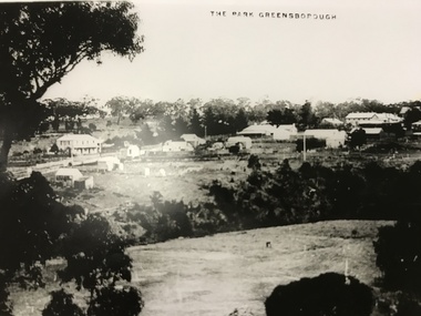
Photograph, The Park Greensborough, 1900c
View of Greensborough Park from Partington's Hill, showing sporting ground, Plenty River, Marble Hall, sparse housing on north side of Main Road, the Farmers' Arms hotel, the Rechabite Hall and Main Road bridge over the the railway line. Marble Hall is the double-storied building on the corner of Main Road.Part of a collection of 5 enlarged photographs dating from the early 1900s.Black and white enlargement of photographgreensborough park, main street greensborough, rechabite hall, farmers' arms hotel, marble hall, greensborough railway -
 Greensborough Historical Society
Photograph, Main Road bridge looking to township of Greensborough, 1929c
View of Main Street Greensborough from Partington's Hill including Plenty River bridge and Marble Hall on corner of Carter Street (now Para Road) and Main Street. This view of Greensborough Park shows the old pan toilets, the hawthorn fence line and the rather undeveloped roadside area of the park. Looking up Main Street we see the old Chapman house at the corner of Poulter Avenue and some newer houses below this. The stone river bridge appears to be only a single lane wide and the road approaching the bridge is unsealed. The rail bridge shows evidence of soot from steam trains and at the extreme left of picture the two concrete buildings indicate the line had been electrified. This occurred in 1923. Sparse housing is seen in the Flintoff Street and Grimshaw Street area.Part of a collection of photographic enlargements of views of Greensborough in the early 1900s.Black and white enlargement of photographic imagemain street greensborough, marble hall, greensborough railway, chapman house, greensborough park, poulter avenue greensborough, carter street, para road -
Glenelg Shire Council Cultural Collection
Photograph - Photograph - Annie Clarke's Ladies School, Gawler Street, 1970s
Anne Clarke was born in Devon around 1814 and arrived in Portland in 1854 aboard the "Francis Henty". She opened Portland's first "Ladies School" which she operated until 1891. Many young ladies from the Western District passed through the school, and in some cases, two generations of girls. It is thought that before coming to Australia, Anne taught at a school for the daughters of clergymen at Cowan Bridge, Lancashire, aptly named the Clergy Daughters' School. It was attended by the Bronte sisters and is said to have inspired the Lowood School in Charlotte Bronte's "Jane Eyre". Anne Clarke never married and died in Portland in 1892.Photographic print of a rephotographed photograph. Image of single storey building, front view, verandah, wooden shingle roof. A number of girls of various ages and some adults, standing on verandah. Annie Clarke's ladies school, 52 Gawler Street.anne clarke, seminary for young ladies, gawler street, portland -
Glenelg Shire Council Cultural Collection
Postcard - Postcard - Portland Harbour, 1930s
Owned by James and Ada Brimblecomber, Heywood, and then by Merle Lewis, Mt. Gambier.Black and white photographic image of a harbour with two long piers running into it and a shorter jetty with a building on it and a circular jetting protruding from it. In the foreground are trees, a dirt road with an RACV sign bridging it to the right and a railway track visible between the trees.Front: THE HARBOUR, PORTLAND (printed, lower centre) -
Glenelg Shire Council Cultural Collection
Photograph - Photograph - Portland Harbour Trust - New store and workshop area 22/1/53, 1953
Port of Portland Authority archivesFront: NEW STORE BUILDING AND WORKSHOP AREA 22/1/53/ VIEW FROM CLIFF ST. BRIDGE (lower centre) Back: P.H.T./ Print No. 3/8 Neg. No 110/ Date taken 22.1.53./ SUBJECT./ % (Ink stamp with blue pen and pencil additions, centre)port of portland archives -
 Glenelg Shire Council Cultural Collection
Artwork, other - Illustration Portland Barton's Beach, n.d
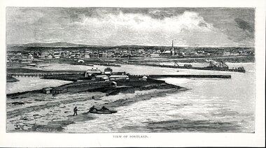
Illustration. Taken and cut from a book. Black and White rectangle image on off white paper. Portland from Barton's Beach, looking north west. Panoramic view in background of Portland's town with original buildings. All Saints Catholic Church with spire recognisable. Pier in the Middle right with various structures and a docked ship with sails. Bottom left 3 people launching two canoes at the beach. Wattle Creek or Salt Creek with bridge structure on the middle left. Front: 'VIEW OF PORTLAND' - printed, bottom frame. Signature 2cm in from the left corner of the frame 'CALVERT. SS'portland, bartons beach, portland bay -
 Glenelg Shire Council Cultural Collection
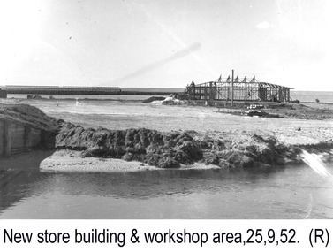
Photograph - Photograph - Portland Harbour Trust - New store and workshop area, 25.9.52, 1952
Port of Portland Authority archivesFront: NEW STORE BUILDING AND WORKSHOP AREA 25.9.52./ VIEW FROM CLIFF ST. BRIDGE (lower centre) Back: P.H.T./ Print No. 3/4 Neg. No 5/ Date taken 25-9-52/ SUBJECT./ % (Ink stamp with blue pen and pencil additions, centre)port of portland archives -
Glenelg Shire Council Cultural Collection
Photograph - Photograph - Portland Harbour Trust - Engineer's office from Cliff St Bridge 23/2/53, 1953
Port of Portland Authority archivesFront: ENGINEER'S OFFICE FROM CLIFF ST. BRIDGE 23/2/53 (lower centre) Back: P.H.T./ Print No. 3/15 Neg. No 141/ Date taken 23.2.53./ SUBJECT./ % (Ink stamp with blue pen and pencil additions, centre)port of portland archives -
Glenelg Shire Council Cultural Collection
Photograph - Photograph - Portland Harbour Trust - New store building & workshop area, 1952
Port of Portland Authority archivesFront: NEW STORE BUILDING AND WORKSHOP AREA 4.12.52./ VIEW FROM CLIFF ST. BRIDGE. (lower centre) Back: P.H.T./ Print No. 3/6 Neg. No 82/ Date taken 4-12-52/ SUBJECT./ % (Ink stamp with blue pen and pencil additions, centre)port of portland archives -
Glenelg Shire Council Cultural Collection
Photograph - Photograph - Portland Harbour Trust - New store building & workshop area, 1952
Port of Portland Authority archivesFront: NEW STORE BUILDING AND WORKSHOP AREA 5.11.52/ VIEW FROM CLIFF ST. BRIDGE. (lower centre) Back: P.H.T./ Print No. 3/5 Neg. No 33/ Date taken 5-11-52/ SUBJECT./ % (Ink stamp with blue pen and pencil additions, centre)port of portland archives -
Glenelg Shire Council Cultural Collection
Photograph - Photograph - Portland Harbour Trust - New store building & workshop area, 1952
Port of Portland Authority archivesFront: NEW STORE BUILDING AND WORKSHOP AREA 23.12.52/ VIEW FROM CLIFF ST. BRIDGE. (lower centre) Back: P.H.T./ Print No. 3/7 Neg. No 97/ Date taken 23-12-52/ SUBJECT./ % (Ink stamp with blue pen and pencil additions, centre)port of portland archives -
Glenelg Shire Council Cultural Collection
Photograph - Photograph - Portland Harbour Trust - Engineer's office from Cliff St Bridge 22/1/53, 1953
Port of Portland Authority archivesFront: ENGINEER'S OFFICE FROM CLIFF ST. BRIDGE 22/1/53/ MODEL SHED, STORES FENCE & 3 PHASE POWER SUPPLY IN COURSE OF ERECTION (lower centre) Back: P.H.T./ Print No. 3/14 Neg. No 109/ Date taken 22.1.53./ SUBJECT./ % (Ink stamp with blue pen and pencil additions, centre)port of portland archives -
Glenelg Shire Council Cultural Collection
Photograph - Photograph - Portland Harbour Trust - Engineer's office from Cliff St Bridge 23/12/52, 1952
Port of Portland Authority archivesFront: ENGINEER'S OFFICE FROM CLIFF ST. BRIDGE 23/12/52/ MODEL SHED, STORES FENCE & 3 PHASE POWER SUPPLY IN COURSE OF ERECTION (lower centre) Back: P.H.T./ Print No. 3/13 Neg. No 96/ Date taken 23.12.52./ SUBJECT./ % (Ink stamp with blue pen and pencil additions, centre)port of portland archives