Showing 1063 items matching "campus plan"
-
 Federation University Historical Collection
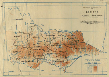
Map, Victoria: Regions for Planning and Development, 1944, 1944
This map was produced for the State Regional Boundaries Committee Two colour map of Victoria showing the regions for planning and development. The regions are Central Highlands, Mallee, Wimmera, Glenelg, Corangamite, Barwon, Loddon, Goulburn, Upper Goulburn, Upper Murray, East Gippsland, West Gippsland, Port Phillip.central highlands, mallee, wimmera, glenelg, corangamite, barwon, loddon, goulburn, upper goulburn, upper murray, east gippsland, west gippsland, port phillip, victoria, m4486 -
 Federation University Historical Collection
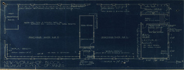
Plan, New Workshop Block Ballarat School of Mines
It is not known which building these plans belong to. Since there is a Heat Treatment Room and a number of vices it may be a metalwork room, and may be related to Repatriation classes after World War One. Blueprint of plans for a new workshop at the Ballarat School of Mines. The plan includes a lecture room, bulk store, tool store, heat treatment room, office and two machine shops. Around the machine shops are work benches and vyces (sic)new workshop block, ballarat school of mines, repatriation, buildings -
 Federation University Historical Collection
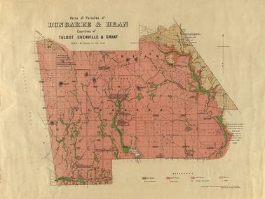
Plan, Bungaree and Dean Parish and Geological Plan, 1890, 07/1890
Ferdinand M. Krause was a Professor at the Ballarat School of Mines.Geological and Parish Map of parts of the Parishes of Bungaree and Dean in the Counties of Talbot, Grenville and Grant. The scale is 40 chains to one inch. bungaree, deen, krause, f.m. krause, musk creek, clarkes hill, badger hill, beale's reservoir, acquainted. -
 Federation University Historical Collection
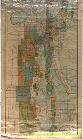
Map, Municipality of Ballarat East, 1857
Gold was discovered in Ballarat in 1851. This plan was created six years later and names some of the great gold locations of Ballarat East. It also shows the locality of the Eureka Stockade (1854) and the walking tracks and roads on the Ballarat East Goldfield.In 2007 this map was listed on the inaugural Ballarat Treasure's Register.Large map backed onto linen. The map has read and blue highlights, and identifies areas such as Mount Pleasant, Golden Point, White Flat, Nightingale, Malekoff, Old Post Office Hill, Red streak, Gumtree Flat, Old Gravelpits, Bakery Hill, Ballaarat Flat, The Camp, Specimen Gully, Pennyweight Hill, Warrenheip Gully, Gays Gully, Pennyweight Flat, Eureka, Black Hill, Pinchgut, Crocodile, Hit or Miss, Little Bendigo, Brown Hill, Mopoke, Cricket Reserve, Canadian Hotel, Ballarat Eastmount pleasant, golden point, white flat, nightingale, malekoff, old post office hill, red streak, gumtree flat, old gravelpits, bakery hill, ballaarat flat, the camp, specimen gully, pennyweight hill, warrenheip gully, gays gully, pennyweight flat, eureka, black hill, pinchgut, crocodile, hit or miss, little bendigo, brown hill, mopoke, cricket reserve, canadian hotel, ballarat eastm phillips, john phillips, field draughtsman, ballarat east, ballarat east map -
 Federation University Historical Collection
Booklet, Meredith Fletcher, Alumni 2002, 2002
Federation University Australia was established on 1 January 2014. Formerly known as the University of Ballarat, its enabling legislation was the University of Ballarat Amendment (Federation University Australia) Act 2013. On 1 January 2014, the University of Ballarat amalgamated with the Monash University Gippsland Campus to form Federation University Australia. The Gippsland Campus also had a long lineage dating back to 1928 with the establishment of the Yallourn Technical School which became a predecessor institution to the Gippsland College of Advanced Education formed in 1968. In 1990, it was renamed the Monash University College and in 1993 became the Gippsland Campus of Monash University. In 2016, Federation University Australia announced plans to take possession, over a two-year period, of Monash’s Berwick Campus in the south-east corridor of Melbourne. Federation University Australia, or FedUni, is headquartered in Ballarat and offers programs in Higher Education and Vocational Education and Training to regional Victoria and beyond. The University’s commitment to educational and social equity, teaching excellence, research distinction, environmental sustainability and regional capacity building has enabled it to develop in a way that draws on its proud heritage to inform its future. Its regional character sets a framework for the University’s priorities but does not constrain it from serving wider community interests, nationally and internationally. The name Federation University Australia was chosen to convey the scope and capacity of an expanded regional university with a federated network of campuses. History of the Gippsland Campus of Federation University located at Churchill.gippsland history, yallourn technical school, brian mckenzie, latrobe valley, gippsland institute of advanced education, monash university gippsland campus, yallourn, sec, peter farago, churchill campus, gippsland campus, binishell, tom kennedy, meredith fletcher, loy yang power station, yallourn open cut, yallourn power station, r.d. dixon, howard beanland, yallourn w. power station, dante bini, bini shell, sculpture, churchill, gippsland campus collection -
 Federation University Historical Collection
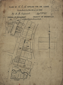
Plan, Lease Applied for by R.M. Serjeant, c1890, c1890
Plan of a lease showing streets around Skipton and Windermere Streets, Redan. Scale 4 chains to 1 inch (!:3168)serjeant, r.m.serjeant, robert m. serjeant, george street, skiptn street, windermere stret, rubicon stret, cobdon street, ascot street, lease, redan, ballarat, robert malachi serjeant, band of hope and albion mine -
 Federation University Historical Collection
Documents, J.H. Brown, Ballarat School of Mines Cyanide Plant and Caretaker's Cottage, 1914
The Ballarat School of Mines building along Albert Street were moved or demolished to make way for the new Engineering Workshop. William Henry Middleton was President of the Ballarat School of Mines from 1912 to 1940.Particulars for removal of the Ballarat School of Mines Caretaker's Quarters and Cyanide buildings are handwritten onto a foolscap page (.1). Three plans are hand-drawn in pencil, these are: (.2) Cyanide Building (.3) Caretaker's Quarters (.4) Caretaker's Quarters - South End Elevationballarat school of mines, new engineering workshop, j.h. brown, william middleton -
Federation University Historical Collection
Booklet, Ballarat School of Mines, Ballarat School Of Mines Agenda for meeting with Chairman of the TAFE Board, 07/1985
Yellow covered A$ booklet bound with plastic. The book as in agenda for a meeting with I. Predl, acting Chairman of the TAFE Board. Items for discussion were: * L.F.J. Hillman Recreation Building * Maintenance of Buildings * Campus titles and future development * Quality Improvements * College Management Study * Uncertainties Re Blackburn The booklet also includes an aerial photograph of the Ballarat School of Mines campus, including dates each building was erected. The image shows the site of the newly demolished Ballarat Gao, and still has a tennis court and Mining laboratory onsite. The book also show allotment plans of the Ballarat School of Mines site. -
 Federation University Historical Collection
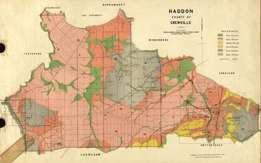
Plan, Haddon, County of Grenville, 1932, 13/04/1932
The Haddon Parish Plan shows crown parcels government roads, Crown Reserves, Railway. Scale 40 chains to 1" (1:31, 680) WGS 84 Centroid Lat: 37 degrees 34' 00" S Long: 148 degrees 40' 20" E N.S. 9.3km E.W.: 16.1kmhaddon, grenville, cardigan, water supply reserve, nentingbook pre-emptive right, a. mclachlan, lake burrumbeet, e.a. wynne, p. russell, b. hepburn, benjamin hepburn, nentingbool, t.c. wilson, j. amoy, william collard smith, james roach, j. mitchell -
 Federation University Historical Collection
Plan, Haddon, County of Grenville, 1887, 1889
Ferdinand Krause taught at the Ballarat School of MinesGeological Map of Haddon in the County of Grenville surveyed by Ferdinand Krause. haddon, grenville, krause, ferdinand krause, cgt, lake burrumbeet, windermere, chepstowe, bailies creek, snake valley lead, nentingbool preemptice right, cardigan state forest, haddon state forest -
 Federation University Historical Collection
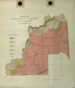
Plan - Map, Mines Department, Parish of Narmbool and part of Cargerie, County of Grant, 1892, 06/1992
This map shows the position of the homestead on the Narmbool Pre-emptive Right, volcanic craters, stock reserve, quarry and geological eras,Geological map showing Narmbool and part of Cargerie in the County of Grant in five colours, predominantly pink.narmbool, cargerie, narmbool pre-emptive right, williamson's creek, leigh river, green hill, collyer's hill, volcano, crater, krause, ferdinand krause -
 Federation University Historical Collection
Plan, Ballarat Goldfields Geological Survey, 1981
Large coloured plan showing streets, leads, geological zones and shafts. Source 1:10,000ballarat, gold, goldfield, geology, sebastopol -
 Federation University Historical Collection
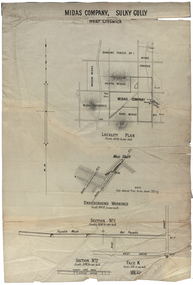
Plan, Midas Company, Sulky Gully near Creswick
Locality and Underground Workings plan for the Midas Company, Sulky Gully near Creswick. Companies shown on the Locality Plan include Dowling Forest No 1., Midas Consols, Madam Midas, Midas Company, King Midas and Midas Extended.dowling forest no 1., midas consols, madam midas, midas company, king midas, sulky gully, creswick, midas extended, cgt -
 Federation University Historical Collection
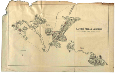
Plan, Haunted Stream Gold Field
Plan of the Haunted Stream Gold Field - scale 16 chains to 1 inchhaunted stream, plan, battery -
 Federation University Historical Collection
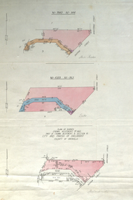
Plan, Plan of Survey Crown Allotment 9A and Part of Crown Allotment 8 Section 10 City and Parish of Ballaarat, after 1929
ink and watercolor on watermarked laid paper dated 1928text and measurementsballaraat, ballarat, plan, plan of survey, armstrong street, skipton street -
 Federation University Historical Collection
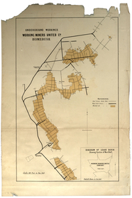
Plan, Underground Workings, Working Miners United Co. Homebush
Printed map on paper various measurements and locationsunderground workings, plan, working miners united co, homebush -
 Federation University Historical Collection
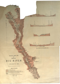
Plan, Geological Sketch Map of Portion of Big River
Printed map on paperscale, index to colours, sectionsgeological sketch map, plan, big river, mount wills, geology -
 Federation University Historical Collection
Map, Ballarat and Sebastapol Gold Mines, Late 19th Century
colored printed map on paper lined onto linen backingprinted "Rider & Mercer's Plan of the Ballarat & Sebastapol Gold Mines Scale 30 Chains to One Inch"gold mines, mine allotment map, mining leases, ballarat, sebastopol, rider and mercer, golden shaft co, prince of wales and bonshaw united, leviathan gold mines, holst and co, speedwell co, sebastopol plateau, rothschild co, tower hill co, south plateau, south star co, band of hop and albion consols, prince regent co, chenhall and co, despza, buninyong estate, one eye hully, winter's freehold, luplau plateau, e. morey, carrill's quartz -
 Federation University Historical Collection
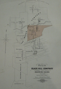
Plan, Plan of the Black Hill Company & Adjoining Claims
Plan of the Black Hill Company & Adjoining Claims. The No 1 Queen claim has been shaded in a buff colour. Scale 300 feet to one inch (1:3600) Shows Dan Brophy's Shaft, Red's Shaft, Two Ton Shaft, Shows the following prospecting company's claims: The Black Hill Company, No. 3 Queen, No. 1 Queen, North Sulieman Pasha, Sulieman, Duchess Co, Parade Co, Pasha Co, Sulieman Pasha Co, Llanberris Co Shows the following streets: Clissold Street, Peel Street, Victoria Street, Humffray Street, Princes Street, Wills Street, King Streetblack hill company, black hill, niven, f.w. niven, sulieman, duchess company, llanberris, cgt -
 Federation University Historical Collection
Plan, Scarsdale County of Grenville, 1889, 26/01/1889
Rectangular plan of a geological survey edged in masking tape. It is predominantly grey, pink and green, but has some yellow. scale is 40 chains to one inch. (see Cat. No. 1098 for report on the Parish of Scarsdale)scarsdale, grenville, krause, browns and scarsdale, mopianimum, watershed, yarrowee, woady yalloak, timber reserve, department of mines, plans, cgt, crown lands, ferdinand krause -
 Federation University Historical Collection
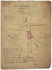
Plan, Quartz Claim by W.H. Hicks, 1888, 1888
The quartz claim was made by W.H. Hicks in 1888.Hand coloured plan showing the area around Darling Street Redan (Ballarat). hicks, redan, yarowee parade, darling street, quartz claim -
 Federation University Historical Collection
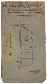
Plan, Lease by Charles Edwin House, 1899, 1899
Plan on waxed linen for a lease by Charles Edwin House.house, charles house, gold lease, ballarat, alluvial claim -
 Federation University Historical Collection
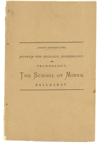
Book - catalogue, Charles Boyd, Museum for Geology, Mineralogy, Technology, Ballarat School of Mines, Ballaarat, 1882, 1882
The Ballarat School of Mines, Museum and Laboratories were open for inspection free in 1882, and an officer was ready to accompany and afford information to visitors. A brown soft covered book of 94 pages. It is a descriptive catalogue of the Minerals in the Museum of the Ballarat School of Mines by Ferdinand M. Krause, curator. Illustrations include a plan of the museum and a plan of the Ballarat school of Mines grounds and buildings. The book is indexed.ballarat school of mines, museum, krause, botanic garden, geology, oddie, james oddie, minerals, ferdinand krause, ballarat school of mines museum, ferdinand krause -
 Federation University Historical Collection
Plan, Ballarat School of Mines New Classrooms (now Administration Building), 1899
2 copies on paper: .1) Admin buildings .2) Admin buildingsballarat school of mines, new classrooms, administration b, zeek -
 Federation University Historical Collection
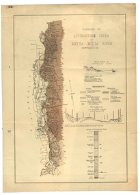
Plan, Livinstone Creek and Mitta Mitta River
Plan showing geological eras and soil types. Scale 80 chains to 1 inchmitta mitta, mitta mitta river, hinnomunjie flats, mining, shafts, livingstone creek -
Federation University Historical Collection
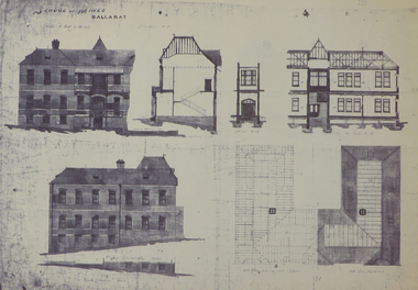
Plan, School of Mines Ballarat
Watercolor architectural drawing on paper depicting the Ballarat School of Mineslower left corner "Drawn by H.L Coburn: 1915"coburn, architecture, ballarat school of mines, plan -
 Federation University Historical Collection
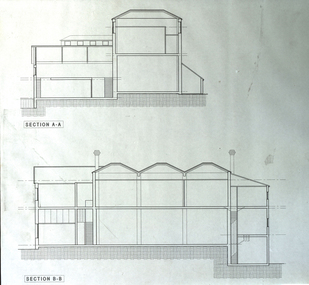
Plan - Plans, Ballarat School of Mines Old Chemistry Building Refurbishment Plans
The Old Chemistry Building on the Federation University Australia SMB campus is one of the earliest remaining buildings used at the Ballarat School of Mines.Digital copies of refurbishment plans for University of Ballarat's refurbishment plans for the Old Chemistry Building, Ballarat School of Mines Campus.ballarat school of mines, old chemistry building, refurbishment, smb campus -
 Federation University Historical Collection
Book, Memoirs of the Geological Survey of Victoria No 14 The Ballarat Goldfields, 1923, 1923
William Baragwanath was educated at the Ballarat School of Mines, obtaining a Geology Certificate in 1911. After further study he went on the become Secretary for Mines, and Chief Mining Surveyor. Baragwanath was a Councillor of the Ballarat School of Mine from 1916 to 1950.Pink covered foolscap book of 257 pages and 32 maps and plans by William Baragwanath. Contents include topography, physiography, historical, geology, basalt, faults, dykes, minerals leads, alluvial mines, nuggets, structure of Ballarat West goldfields, structure of Ballarat East gold-field, quartz formation, indicators, defunct mines, existing mines, table of deepest shafts. Images include: section of the Ballarat Gold-Field, Dead HOrse Flat, lakes formed by Basalt Flows, Gong Gong Creek, Frenchman's Lead, Ballarat West Mines, LEases and positions of shafts (1857), puddling, White Horse Lead, Woah Hawp Canton, Ballarat Township mines, Sebastopol, syncline, Victoria United Line, First Chance Mine, Llanberris No 1 Mine, Saddle Reef, New Normanby Mine, Woah Hawp Canton Mine, South Star Mine, Sebastopol Plateau, south Woah Hawp Mine, Woah No. 2 Minegeology, geological survey no 14, ballarat, baragwanath, william baragwanath -
Federation University Historical Collection
Book, Geologiocal Survey of Victoria No 4. The Ballarat East Goldfield, 1907, 1907
.1) 52 page fooslcap book with 41 plates and plans. Mines include News Zealand Trust, Lannberris No 1, etc. .2) Photographic image taken from the book ballarat east, ballarat east goldfield, mining, gregory, j.w. gregory, geological survey no. 4, llanberris -
 Federation University Historical Collection
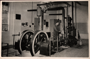
Photograph - Photograph - Black and white, Ballarat School of Mines Model Steam Engine
The Davey Paxman Experimental Steam Engine was purchased as the result of a bequest from Thomas Bath. The 'substantial sum' was used to build an Engineering Laboratory. The Ballarat School of Mines Council minutes of 08 November 1901 record: - Plans for [the] proposed building were submitted ... and ... it was resolved that a temporary building for an Engineering Laboratory be put up.' This laboratory, as an existing building, is first mentioned in the Ballarat School of Mines President's Annual Report of 1901, presented on 28 February 1902, reporting 'the erection of a building 67ft long by 33 ft wide' This report also lists all the equipment that would be accommodated in the Engineering Laboratory, including the experimental steam engine and boiler. The experimental Davey-Paxman steam engine arrived in Ballarat towards the end of 1902. The Engineering Laboratory was opened on 14 August 1903 by His Excellency Sir Sydenham Clarke. This engineering laboratory remained in use till about 1945. By 1944 preparations were under way at the Ballarat School of Mines to expand existing facilities, to be ready for the influx of returned soldiers. A new Heat Engines laboratory was built, this time of brick construction, replacing the previous corrugated-iron shed. In the early stages the steam engine was used to drive an overhead transmission shaft for machinery in the adjacent workshop. Later the steam engine was moved to a space that became the Heat Thermodynamics Laboratory. At the end of 1969 the engine was relocated to the Thermodynamics Laboratory at the then Ballarat Institute of Advanced Education (BIAE) Mt Helen Campus. It was donated to Sovereign Hill in 2006. According to the research of Rohan Lamb in 2001 around five experimental steam engines were made by Davey Paxman, and three of these had similar configuration to the Ballarat School of Mines Steam Engine, however, each of these was also unique with different valve arrangements. The list, which was on a scrap of paper in a folio held in the Essex Archives, confirmed that one was sent to India. The Ballarat steam engine can be dated to late 1901 to early 1902. Zig Plavina was responsible for moving the steam engine to Mount Helen, and worked on it as a technician for many years. He observed the following: * The condenser is driven by the low pressure engine. * The following arrangements are possible: i) the high pressure engine alone, exhausting to atmosphere. Condenser not used, crankshaft flanges not coupled. ii) crankshafts coupled, mains pressure (120 psi) steam supplied to high pressure engine, partially expanded steam delivered to low pressure engine (Tandem operation). Choice available re exhaust steam: either to the condenser or to atmosphere. iii) crankshafts not coupled, reduced pressure steam supplied to low pressure engine. Exhaust steam - either to the condenser or to atmosphere. * Valve arrangement - a choice of Pickering cut-off or throttle governor. On low pressure engine - throttle governor only.Black and white photograph of the Davey Paxman Experimental Steam Engine installed at the Ballarat School of MInes. steam engine, model steam engine, davey paxman, thomas bath, experimental steam engine