Showing 741 items
matching charts
-
 Queenscliffe Maritime Museum
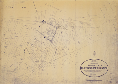
Map - Survey Chart, J. P. Larkin, Re-Survey of Queenscliff Channel, 29 October 1928
A paper chart showing sounding around the Queenscliff Channel dated 1928Victoria Port Phillip October 1928, Re survey of Queenscliff Channelqueenscliff channel, surveying, navigation -
 Kew Historical Society Inc
Book, Libraries Board of South Australia, Narrative of a Survey of the Coasts of the Intertropical and Western Coasts of Australia performed between the Years 1818 and 1822 in two volumes (Vol.1), 1969
This two-volume work by Captain Phillip Parker King (1791–1856) was published in 1827, and describes the Royal Navy's 1817–22 surveying expedition to chart the coastal regions of Australia. King carried out the surveys in two successive ships, the Mermaid, which was declared unseaworthy in 1820, and the newly commissioned Bathurst. He worked on the charts, which were published by the Hydrographic Office, for two years after his return to England. He was made a Fellow of the Royal Society, and later undertook a similar surveying voyage, in which he was accompanied by Captain Fitzroy on the Beagle, around the coast of South America. The book is derived from the author's journal, and describes not only the voyages but also the towns and settlements of the region. Volume 2 continues the survey along the north and west coasts of Australia, and contains an appendix describing winds, currents, ports and islands.Facsimile Editions No.30. 2 v. : illus., fold. charts, tables. non-fictionThis two-volume work by Captain Phillip Parker King (1791–1856) was published in 1827, and describes the Royal Navy's 1817–22 surveying expedition to chart the coastal regions of Australia. King carried out the surveys in two successive ships, the Mermaid, which was declared unseaworthy in 1820, and the newly commissioned Bathurst. He worked on the charts, which were published by the Hydrographic Office, for two years after his return to England. He was made a Fellow of the Royal Society, and later undertook a similar surveying voyage, in which he was accompanied by Captain Fitzroy on the Beagle, around the coast of South America. The book is derived from the author's journal, and describes not only the voyages but also the towns and settlements of the region. Volume 2 continues the survey along the north and west coasts of Australia, and contains an appendix describing winds, currents, ports and islands.australia -- description and travel -- to 1850., hydrography -- australia., natural history -- australia. -
 Ringwood RSL Sub-Branch
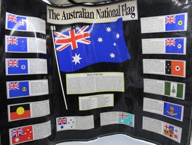
Work on paper - Australian national flags, Various designs of the Australian National Flag
Paper chart showing various designs of different Australian National Flags -
 Flagstaff Hill Maritime Museum and Village
Map - Navigation Chart, Celebes - Tomori Gulf to Salaya Strait
British Admiralty Navigation Chart - Celebes - Tomori Gulf to Salaya straitwarrnambool, shipwrecked-coast, flagstaff-hill, flagstaff-hill-maritime-museum, maritime-museum, shipwreck-coast, flagstaff-hill-maritime-village, british admiralty, navigation chart, celebes, tomori gulf to salaya strait -
 Bendigo Historical Society Inc.
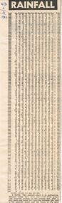
Newspaper - RAINFALL CHART, 1983
Rainfall Chart; Bendigo Advertiser 2/3/1983. Chart shows rainfall from 1863 to1983. It is noted at the bottom that the rainfall chart is in millimetres. Monthly totals have been converted from points (the imperial system) to the nearest mm. This is why there are some discrepancies between the sum of the monthly totals and the figure in the total column. Box 625bendigo, newspapers, bendigo advertiser, bendigo advertiser. rainfall chart. -
 Victorian Aboriginal Corporation for Languages
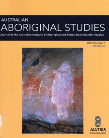
Periodical, Australian Institute of Aboriginal and Torres Strait Islander Studies, Australian Aboriginal studies : journal of the Australian Institute of Aboriginal and Torres Strait Islander Studies, 2007
1. The moral lexicon of the Warlpiri people of central Australia LR Hiatt This paper discusses words that match ?Good? and ?Bad?; examples of ?Good? and ?Bad? behaviour; morality and law; and egalitarianism and dominance. It also presents a comparison with Gidjingarli (Burarra). 2. Mobs and bosses: Structures of Aboriginal sociality Patrick Mullins (Mount Druitt, NSW) A commonality of Aboriginal social organisation exists across the continent in communities as different as those from the Western Desert across to Cape York, from the towns of New South Wales and Western Australia to cities like Adelaide. This is found in the colloquial expressions ?mob? and ?boss?, which are used in widely differing contexts. Mobbing is the activity where relatedness, in the sense of social alliances, is established and affirmed by virtue of a common affiliation with place, common experience and common descent, as well as by the exchange of cash and commodities. Bossing is the activity of commanding respect by virtue of one?s capacity to bestow items of value such as ritual knowledge, nurturance, care, cash and commodities. Mobbing and bossing are best understood as structures in Giddens? sense of sets of rules and resources involved in the production of social systems, in this case social alliances. Mobbing and bossing imply a concept of a person as a being in a relationship. Attention needs to be given to the way these structures interact with institutions in the wider Australian society. 3. Recognising victims without blaming them: A moral contest? About Peter Sutton?s ?The Politics of Suffering: Indigenous Policy in Australia since the 1970s? and Gillian Cowlishaw?s replies Ma�a Ponsonnet (Universit� Paris- 8-Saint-Denis) Peter Sutton?s texts on Aboriginal violence, health and their politicisation are replied to using his methodology, and acknowledging his convincing points. Sutton rightly denounces a lack of lucidity and scientific objectivity in anthropological debates. These inadequacies impede identification of what Aboriginal groups can do to improve their situations for fear that this identification would lead to blame the victims. At the other end of the ethical spectrum, those who advocate a broader use of what I will call a ?resistance interpretation? of violence fail to recognise victims as such, on the implicit grounds that seeing victims as victims would deprive them of any agency, on the one hand, and entail blame, on the other hand. I aim to define a middle road between those views: the idea that victims should be acknowledged as such without being denied their agency and without being blamed for their own condition. This middle road allows identification of the colonisers? responsibilities in the contemporary situation of Indigenous communities in Australia, and to determine who can do what. Secondly, I show that Sutton?s texts convey, through subtle but recurrent remarks, an ideology of blame rather than a mere will to identify practical solutions. As a consequence, some of his proposals do not stand on a solid and objective causal analysis. 4. 'You would have loved her for her lore?: The letters of Daisy Bates Bob Reece (Murdoch University) Daisy Bates was once an iconic figure in Australia but her popular and academic reputation became tarnished by her retrograde views. Her credibility was also put in doubt through the exposure of her fictionalised Irish background. In more recent times, however, her ethnographic data on the Aborigines of Western Australia has been an invaluable source for Native Title claims, while her views on Aboriginal extinction, cannibalism and ?castes? are being seen as typical of her time. This article briefly reviews what has been the orthodox academic opinion of her scientific achievement before summarising what is reliably known of her early history and indicating what kind of person is revealed in the 3000 or more letters that she left behind. 5. What potential might Narrative Therapy have to assist Indigenous Australians reduce substance misuse? Violet Bacon (Curtin University of Technology) Substance misuse is associated with adverse consequences for many Australians including Aboriginal and Torres Strait Islander peoples. Extensive research has been conducted into various intervention, treatment and prevention programs to ascertain their potential in reducing substance misuse within Aboriginal and non-Aboriginal communities. I explore the potential of Narrative Therapy as a counselling intervention for assisting Indigenous Australians reduce the harm associated with substance misuse. 6. Bone points from the Adelaide River, Northern Territory Sally Brockwell (University of Canberra) and Kim Akerman (Moonah) Large earth mounds located next to the vast floodplains of the lower Adelaide River, one of the major tropical rivers draining the flat coastal plains of northern Australia, contain cultural material, including bone points. The floodplains of the north underwent dynamic environmental change from extensive mangrove swamps in the mid-Holocene, through a transition phase of variable estuarine and freshwater mosaic environments, to the freshwater environment that exists today. This geomorphological framework provides a background for the interpretation of the archaeology, which spans some 4000 years. 7. A different look: Comparative rock-art recording from the Torres Strait using computer enhancement techniques Liam M Brady (Monash University) In 1888 and 1898, Cambridge University?s Alfred C Haddon made the first recording of rock-art from the Torres Strait islands using photography and sketches. Systematic recording of these same paintings and sites was carried out from 2000 to 2004 by archaeologists and Indigenous Torres Strait Islander and Aboriginal communities as part of community-based rock-art recording projects. Computer enhancement techniques were used to identify differences between both sets of recordings, to reveal design elements that Haddon missed in his recordings, and to recover images recorded by Haddon that are today no longer visible to the naked eye. Using this data, preliminary observations into the antiquity of Torres Strait rock-art are noted along with recommendations for future Torres Strait region rock-art research and baseline monitoring projects. 8. Sources of bias in the Murray Black Collection: Implications for palaeopathological analysis Sarah Robertson (National Museum of Australia) The Murray Black collection of Aboriginal skeletal remains has been a mainstay of bio-anthropological research in Australia, but relatively little thought has been given to how and why this collection may differ from archaeologically obtained collections. The context in which remains were located and recovered has created bias within the sample, which was further skewed within the component of the collection sent to the Australian Institute of Anatomy, resulting in limitations for the research potential of the collection. This does not render all research on the collection unviable, but it demonstrates the importance of understanding the context of a skeletal collection when assessing its suitability for addressing specific research questions.maps, b&w photographs, colour photographs, illustrations, graphs, chartswarlpiri, sociology, daisy bates, substance abuse, narrative therapy, rock art, technology and art, murray black collection, pleistocene sites, watarrka plateau -
 Victorian Aboriginal Corporation for Languages
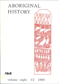
Periodical, Australian National University Department of Pacific and Southeast Asian History, Aboriginal history, 1984
maps, b&w illustrations, b&w photographs, graphs, charts -
 Victorian Aboriginal Corporation for Languages
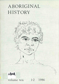
Periodical, Australian National University Department of Pacific and Southeast Asian History, Aboriginal history, 1986
maps, b&w photograph, graphs, charts, reproductions of historic items -
 Victorian Aboriginal Corporation for Languages
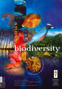
Book, Department of Natural Resources and Environment, Victoria's biodiversity : directions in management, 1997
Looking at Victoria in each region and examining the biodiversity of the environment, for management purposes.Maps (including two large maps) charts, graphs, colour photographs,biodiversity, sustainability, conservation -
 Bendigo Historical Society Inc.
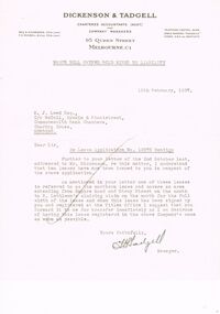
Document - MCCOLL, RANKIN AND STANISTREET COLLECTION: NELL GWYNNE SYNCLINE
Manilla folder of documents relating to the Nell Gwynne Syncline Mining lease. Mentioned are Lease No.'s 10875 and 10903 which is in the Empire Road Stray Street area; R. Lethlean's Sluicing Claim; Albert Selisky has permissive Occupancy on ¼ acre; New Chum Syncline; Liddell's Chenical and Metallurgical Works; Arum Dredging Development NL. Application for a Hydraulic Sluicing Lease; Transfer of lease No. 10903, from H.J. Leed to North Nell Gwynne Gold Mines NL; Application form for the Nell Gwynne Syncline Co.. Application for leases 10945 and 10946; Nell Gwynne Syncline option to purchase lease 10945 for £1,000; Consent from Minna Matilda Lawson for inclusion of part of allotment 268 in lease No. 10875.Dickson & Tadgell Charted Accountants, 95 Queen Street, Melbourne C1gold, mining, land application, nell gwymme syncline, gold mines, bendigo -
 Flagstaff Hill Maritime Museum and Village
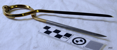
Functional object - Map Calipers/ Divider, Unknown
Compass, divider, and caliper are basically instruments that have two legs pivoted to each other at the top and are concerned with small-distance measurement or transfer. The compass and divider have straight legs; the caliper has curved legs. Dividers and Calipers were known to both the Greeks and Romans, though the caliper was uncommon. A divider with a circular sector, or wing, connecting the two legs was sketched in 1245, its modern counterpart is the wing divider with a thumbscrew clamp and screw for fine adjustment. Or the marine dividers used to measure the distance a vessel has travelled by transferring the vessels distance from a map with the divider and transferring that measurement to a marine ruler to mathematical calculate the distance.Item is believed to be a replica/ copy of a 19th century map calipers used in marine navigation to determine distance travelled. Item was probably purchased between 1972-1975 to add to the marine displays at Flagstaff Hill.Stainless steel dividers used in navigation charts. Top half is alloy plated. "W & HC" and "Made in England".flagstaff hill, warrnambool, shipwrecked-coast, flagstaff-hill, flagstaff-hill-maritime-museum, maritime-museum, shipwreck-coast, flagstaff-hill-maritime-village, stainless steel dividers, steel dividers, dividers -
 Flagstaff Hill Maritime Museum and Village
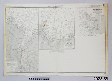
Document - Navigation Chart, Plans in Tasmania - Foster Inlet, River Mersey and Emu Bay
Navigation Chart - Plans in Tasmania - Foster Inlet, River Mersey and Emu Baywarrnambool, shipwrecked-coast, flagstaff-hill, flagstaff-hill-maritime-museum, maritime-museum, shipwreck-coast, flagstaff-hill-maritime-village, shipwrecked-artefact, river mersey, foster inlet, emu bay, navigation chart -
 Federation University Historical Collection
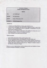
Document - Document - Project, VIOSH: University of Ballarat, Strategic Plan; Quality Management Project 1994
Victorian Institute of Occupational Safety and Health (VIOSH) Australia is the Asia-Pacific centre for teaching and research in occupational health and safety (OHS) and is known as one of Australia's leaders on the field. VIOSH has a global reputation for its innovative approach within the field of OHS management. VIOSH had its first intake of students in 1979. At that time the Institution was known as the Ballarat College of Advanced Education. In 1990 it became known as Ballarat University College, then in 1994 as University of Ballarat. It was 2014 that it became Federation University. VIOSH Australia students are safety managers, senior advisors and experienced OHS professionals. They come from all over Australia and industry. Students are taught active research and enquiry; rather than textbook learning and a one-size fits all approach. VIOSH accepts people into the Graduate Diploma of Occupational Hazard Management who have no undergraduate degree - on the basis of extensive work experience and knowledge. Memo from Don Maconachie was sent to all VIOSH Staff in relation to the development of a VIOSH Strategic Plan. They were to develop value statement, vision statement, aims, goals, objectives, targets, strategies. Staff provided with forms to be completed coving these aspects. They were to state the responsible person, timeline, target groups, resources required and indicators of success. On completion results compiled and given to staff. Report would then be sent to Director of VIOSH Australia.Forty-two pages that was stapled together in sections. Type written with relevant charts.viosh, victorian institute of occupational safety and health, quality management project, visor strategic plan, don maconachie, mission statement, aims, targets, director -
 Flagstaff Hill Maritime Museum and Village
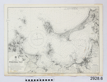
Document - Navigation Chart, Japan, Fukuoka Wan - Kyushu - North Coast
British Admiralty Navigation Chart - Japan, Fukuoka Wan - Kyushu - North Coastwarrnambool, shipwrecked-coast, flagstaff-hill, flagstaff-hill-maritime-museum, maritime-museum, shipwreck-coast, flagstaff-hill-maritime-village, shipwrecked-artefact, british admiralty, navigation chart -
 Flagstaff Hill Maritime Museum and Village
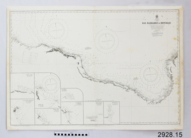
Document - Navigation Chart, Ras Makhabez to Bengazi
British Admiralty Navigation Chart - Africa, North Coast - Ras Makhabez to Bengaziwarrnambool, shipwrecked-coast, flagstaff-hill, flagstaff-hill-maritime-museum, maritime-museum, shipwreck-coast, flagstaff-hill-maritime-village, shipwrecked-artefact, ras makhabez to bengazi, british admiralty navigation chart, navigation chart -
 Flagstaff Hill Maritime Museum and Village
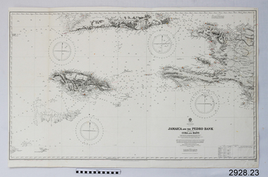
Document - Navigation Chart, Jamaica and the Pedro Bank
British Admiralty Navigation Chart - Jamaica and the Pedro Bank with part of Cuba and Haitiwarrnambool, shipwrecked-coast, flagstaff-hill, flagstaff-hill-maritime-museum, maritime-museum, shipwreck-coast, flagstaff-hill-maritime-village, shipwrecked-artefact, navigation chart, british admiralty navigation chart, pedro bank, jamaica -
 Flagstaff Hill Maritime Museum and Village
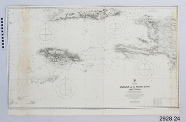
Document - Navigation Chart, Jamaica and the Pedro Bank
British Admiralty Navigation Chart - Jamaica and the Pedro Bank with parts of Cuba and Haitiwarrnambool, shipwrecked-coast, flagstaff-hill, flagstaff-hill-maritime-museum, maritime-museum, shipwreck-coast, flagstaff-hill-maritime-village, shipwrecked-artefact, navigation chart, british admiralty navigation chart, pedro bank, jamaica -
 Flagstaff Hill Maritime Museum and Village
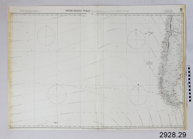
Document - Navigation Chart, South Pacific Ocean - Melbourne to Cape Horn
British Admiralty Navigation Chart - South Pacific Ocean - Melbourne to Cape Hornwarrnambool, shipwrecked-coast, flagstaff-hill, flagstaff-hill-maritime-museum, maritime-museum, shipwreck-coast, flagstaff-hill-maritime-village, shipwrecked-artefact, navigation chart, british admiralty navigation chart, melbourne to cape horn, south pacific ocean -
 Flagstaff Hill Maritime Museum and Village
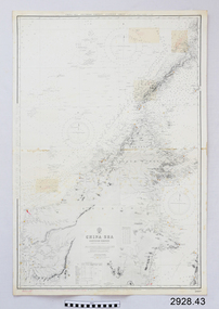
Document - Navigation Chart, China Sea
British Admiralty Navigation Chart - China Sea, Southern Portion - Eastern Sheetwarrnambool, shipwrecked-coast, flagstaff-hill, flagstaff-hill-maritime-museum, maritime-museum, shipwreck-coast, flagstaff-hill-maritime-village, shipwrecked-artefact, navigation chart, british admiralty navigation chart, british admiralty, china sea -
 Flagstaff Hill Maritime Museum and Village
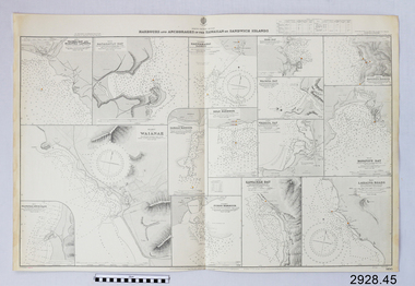
Document - Navigation Chart, Harbours and Anchorages in the Hawaiian Islands or Sandwich Islands
British Admiralty Navigation Chart - Harbours and Anchorages in the Hawaiian Islands or Sandwich Islandswarrnambool, shipwrecked-coast, flagstaff-hill, flagstaff-hill-maritime-museum, maritime-museum, shipwreck-coast, flagstaff-hill-maritime-village, shipwrecked-artefact, navigation chart, british admiralty navigation chart, british admiralty, hawaiian islands -
 Flagstaff Hill Maritime Museum and Village
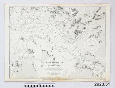
Document - Navigation Chart, A San Anchorage and Approaches
British Admiralty Navigation Chart - Korea - West Coast - A San Anchorage and Approacheswarrnambool, shipwrecked-coast, flagstaff-hill, flagstaff-hill-maritime-museum, maritime-museum, shipwreck-coast, flagstaff-hill-maritime-village, shipwrecked-artefact, navigation chart, british admiralty navigation chart, british admiralty, a san anchorage and approaches -
![Genealogical chart, Chapman family [James Chapman/Susan Palmer], 1744o](/media/collectors/4f729f5697f83e03086015b8/items/50a4628f2162ef10601bdce5/item-media/58be7236d0ce7205ecb82f1f/item-fit-380x285.jpg) Greensborough Historical Society
Greensborough Historical SocietyGenealogical chart, Chapman family [James Chapman/Susan Palmer], 1744o
A detailed list of members of the family of James Chapman and Susan Palmer. James Chapman was a pioneer of the Greensborough District.A 6 page group of family history charts. Complete text available at GHS.Niljames chapman, greensborough, cowlinge, lidgate, susan palmer -
 Flagstaff Hill Maritime Museum and Village
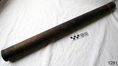
Container - Chart Case, ca 19th century
Black painted metal cylindrical container. Label attached at one end with inscription. "Flagstaff Hill c/ J Lindsay"This chart case is an example of maritime chart storage used in colonial times to protect charts and maps from the weather and to store them is an easily accessible was. Chart case, black painted metal cylindrical container with caps on both ends.flagstaff hill, warrnambool, shipwrecked-coast, flagstaff-hill, flagstaff-hill-maritime-museum, maritime-museum, shipwreck-coast, flagstaff-hill-maritime-village, chart case, navigation, chart storage -
 Victorian Aboriginal Corporation for Languages
Book, Rodger Elliot et al, Plant identikit : common native plants of the Grampians, 1998
This little book features detailed sketches of plants and includes a flowering seasons chart.Colour illustrations, mapsgrampians, plants -
University of Melbourne, Burnley Campus Archives
Document, Productivity Assessment Field Facility, 1982
Memo, notes, chart re productivity in Field Station. Refer to paper catalogue -
Whitehorse Historical Society Inc.
Book, Socio-demographic facts and figures about Nunawading, 1984
Detailed charts of figures, 1984 published by City of Nunawading Strategic Planning Unit.Detailed charts of figures, 1984 published by City of Nunawading Strategic Planning Unit.Detailed charts of figures, 1984 published by City of Nunawading Strategic Planning Unit.local government, city of nunawading, population, statistics, demography -
 Kew Historical Society Inc
Book, Libraries Board of South Australia, Narrative of a Survey of the Coasts of the Intertropical and Western Coasts of Australia performed between the Years 1818 and 1822 in two volumes (Vol.2), 1969
This two-volume work by Captain Phillip Parker King (1791–1856) was published in 1827, and describes the Royal Navy's 1817–22 surveying expedition to chart the coastal regions of Australia. King carried out the surveys in two successive ships, the Mermaid, which was declared unseaworthy in 1820, and the newly commissioned Bathurst. He worked on the charts, which were published by the Hydrographic Office, for two years after his return to England. He was made a Fellow of the Royal Society, and later undertook a similar surveying voyage, in which he was accompanied by Captain Fitzroy on the Beagle, around the coast of South America. The book is derived from the author's journal, and describes not only the voyages but also the towns and settlements of the region. Volume 2 continues the survey along the north and west coasts of Australia, and contains an appendix describing winds, currents, ports and islands.Australian Facsimile Editions No.30. 2 v. : illus., fold. charts, tables. non-fictionThis two-volume work by Captain Phillip Parker King (1791–1856) was published in 1827, and describes the Royal Navy's 1817–22 surveying expedition to chart the coastal regions of Australia. King carried out the surveys in two successive ships, the Mermaid, which was declared unseaworthy in 1820, and the newly commissioned Bathurst. He worked on the charts, which were published by the Hydrographic Office, for two years after his return to England. He was made a Fellow of the Royal Society, and later undertook a similar surveying voyage, in which he was accompanied by Captain Fitzroy on the Beagle, around the coast of South America. The book is derived from the author's journal, and describes not only the voyages but also the towns and settlements of the region. Volume 2 continues the survey along the north and west coasts of Australia, and contains an appendix describing winds, currents, ports and islands.philip parker king, natural history -- australia., australia -- description and travel -- to 1850. -
 Flagstaff Hill Maritime Museum and Village
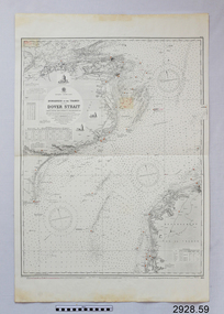
Document - Navigation Chart, Dungeness to the Thames and the Dover Strait
British Admiralty Navigation Chart - England - South Coast - Dungeness to the Thames and the Dover Straitwarrnambool, shipwrecked-coast, flagstaff-hill, flagstaff-hill-maritime-museum, maritime-museum, shipwreck-coast, flagstaff-hill-maritime-village, shipwrecked-artefact, navigation chart, british admiralty navigation chart, british admiralty, dungeness to the thames, dover strait -
Ringwood and District Historical Society
Plan, SGL Consulting Group Aust Pty, Maroondah Leisure Facilities Review / Strategic Plan 2010-2050, May-10
Prepared for the Maroondah City Council, Vol one - Executive Summary of the Maroondah Leisure Facilities Review Strategic Management Plan 2010-20508 A4 double sided printed documents with black and white photos, charts & text -
Federation University Historical Collection
Document - Document - Ballarat College of Advanced Education, Documents relating to Ballarat College of Advanced Education, Staffing, 1976; collected by E.J. Barker
E.J. Barker is a past principal of the School of Mines Ballarat and the Library at the Mt Helen Campus is named after him. Papers relate to the staffing structure at SMB and Ballarat College of Advanced Education, 1976. Various documents, charts, correspondence collected by E.J. Barker related to staffing at BCAE. Victoria e.j. barker, victoria institute of colleges, staffing, school of business studies, school of engineering, derek woolley, school of applied science, e phillips, civil and mining engineering, electrical engineering, mechanical engineering, chemistry, biology, geology, metallurgy, physics, malting and brewing, art, business studies, general studies, mathematics, librarianship, library, computer centre, counselling services, administrative staff, maintenance staff, cafeteria staff, student residence staff, resident nurse, bookshop staff, carpentry and joinery, bricklaying, electrical mechanics, machine shop, motor mechanics, panel beating, plumbing and sheetmetal, telecommunications, welding and blacksmithing, woolclassing, bcae academic staff, ballarat school of mines, ballarat college of advanced education