Showing 443 items matching "drains"
-
 Glen Eira Historical Society
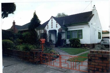
Photograph, Beauville Avenue, 35, Murrumbeena, 2001
Originally labelled "Beauville Estate, Established 1936, Still Thriving 65 years on, 10th March 2001", the Beauville Estate Album contains colour photographs of houses in the Estate. They were taken around the time of the Beauville Estate’s 65th Heritage Celebration held on 10/03/2001 and donated to the Caulfield Historical Society shortly afterwards. Photographer unknown. Windows frames, gutters and drain pipe all painted green but this is same property as 2104A-38 where they are painted black.City of Glen Eira’s Heritage Management Plan Vol 2 p79 (this is p84 of the pdf version) – HO12 Beauville Estate and environs, Murrumbeena: The Beauville Historic Area is important at the State level as the first large housing estate undertaken by the AV Jennings Construction Co, later Jennings Group Limited, Victoria’s largest home builder. It is important also as a very early estate development incorporating a range of features other than houses and including made roads, shops and recreation facilities. In this respect it was the forerunner of the comprehensively planned housing estate of the post war era. The estate is distinguished by its aesthetic values, as is the earlier and comparable Hillcrest Estate, which are formed by a combination of restrained diversity in house styles, with the exception of no. 30 in the emerging International style, and by a landscaped garden environment. Colour photograph of white rendered house with unpainted variegated brown brick features including a geometric pattern of 3 vertical shapes on the gable over the porch. Other features include a wide arched porch, tiled roof and low unpainted reddish brown brick fence in the foreground with "35" on the reddish brown metal letterbox on top of the brick pillar beside the driveway. There are low, red, wrought iron gates across the driveway entrance. Garage has a matching brown brick feature wall.murrumbeena, houses, beauville avenue, architectural styles, 1930's, inter war style, a.v. jennings, av jennings, jennings, brick houses, beauville estate, porches, letterboxes, sir albert victor jennings, a v jennings construction co, beauville estate heritage area, glen eira city council, architectural features, jennings group limited, land subdivision, gardens, beauville historic area, rendered houses, brick features, arches, brick fences, garages (private), gables -
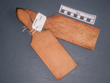
 Forests Commission Retired Personnel Association (FCRPA)
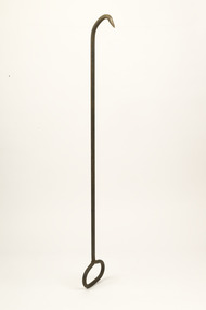
Pulpwood billet hook
Pulpwood was often split by hand or with black powder splitting guns into more manageable sizes and cut into 8 foot lengths (or billets). Billets were first stacked endwise to drain the sap and lighten the load before they were loaded by hand onto flat bed trucks for transport to the mills. This long length metal hook was used to pull and manoeuvre the pulpwood billets onto the truck. The advent of excavators in logging operations in the 1970s led to the loading and carting pulpwood in long tree lengths.Long steel tool with handle on one end and hook on the other. -
 Kew Historical Society Inc
Map, Robert Russell, Map Shewing the Site of Melbourne and the Position of the Huts & Buildings Previous to the Foundation of the Township by Sir Richard Bourke in 1837
Map shows the first layout of Melbourne by Government surveyor Robert Russell, who accompanied Governor Richard Bourke in 1837. The surveyed blocks extend from present-day Flinders Street to Lonsdale Street, and Spring Street to Spencer Street, with extensive vacant land west to a salt lake (afterwards Batman's Swamp, later drained), north beyond Flagstaff Hill and south towards South Melbourne. Vegetation coverage is indicated, and tracks and existing buildings and cultivated land are shown.Printed map was created by Day & Haghe, Lithographers to the Queen, sometime after 1838, when the company received its Royal appointment. Copies of the 1837 map exist in several major map collections in Australia; most are uncoloured. This particular map is the earliest in the Kew Historical Society's map collection. It is a nationally significant artefact. Black and white lithographed map hand-coloured in blue and yellow gouache of the town of Melbourne in 1837. In contrast to the original lithograph, the river and the township blocks are coloured blue and yellow. A similar, partly coloured copy is in the collection of the University of Melbourne.maps - melbourne - 1830s, governor sir richard bourke, robert russell - surveyor, cartography -
 Eltham District Historical Society Inc
Document - Folder, Murray, John and Mary
John Contents Letter: J N Murray to Eltham Historical Society, 16 August 1970. Requests information about the Murray family. Letter: J N Murray to B Wadeson [?Eltham Shire Council], 24 March 1974. Requests information about the Murray family. Letter: Brian R Smyth solicitor to Eltham Historical Society, 31 August 1993: Re estate of J E Murray and contents of buildings and site. Letter: Eltham Historical Society to Bryan Smyth, 7 September 1993: Re contents of buildings and site, in association of Shire of Diamond Valley. Newspaper article: "Back when the land was theirs", Diamond Valley News, 28 September 1992. Interview of James (Jim) Murray about his family and farm. Text: "A development philosophy for 'Murray's", Eltham North", by John R Sabine, September 1994 [history of family and Laurel Hill farm]. Photograph: Grave stone of John Murray, Mary Murray, Thomas Drain and Mary Ellen Drain. Text: "Murray" by A Sheehan, no date. History of Murray family. Text: John Wright Murray", no author, no date: History of John Wright Murray. Newspaper clippings, A4 photocopies, etcjohn wright murray, mary murray nee sweeney, thomas sweeney, diamond creek, zig zag road, eltham cemetery, johnnie murray, james murray, eltham north reserve, bridget sweeney nee coleman, bridget cecilia murray, michael (mick) dillon, hamilton drain, mary ellen drain, thomas drain, john murray, patrick murray, thomas murray, william murray, laurel hill farm eltham, patrick bernard murray, elizabeth josephine tooher, john meyler bagot, thomas vincent murray, margaret gleeson, william louis murray, james augustine murray, julia agnes brennan, william johnston, isaac rooks, john r sabine, murray's bridge, wattletree road eltham, zig zag road eltham, larry brennan, evelyn arms hotel eltham -
Frankston RSL Sub Branch
Boots, Jungle
Jungle boots, Vietnam era, used by U S troops and also acquired by Australian troops, prior to adoption of the US leather GP boots.A pair of jungle boots, as new, that were issued during the Vietnam conflict for U S troops, but also acquired and used by Australian troops. Constructed of leather and green canvas, and the instep of both boots has a pair of circular brass eyelets with a several tiny holes for draining water from inside the boot. They have black rubber soles on both boots . In the arch of the heel is the boot size of '(10W)' and the manufacturers stamping of '(C.I.C.)' which is believed to be associated with the principal manufacturer 'GENESCO'. Inside there is an implant for increased wearer comfort. (CIC) and (10W) on the sole near the arch. The tongue has an ink imprint; (10W) (GJ) (3 68) (SPIKE) (PROTECTIVE) -
 Bendigo Historical Society Inc.
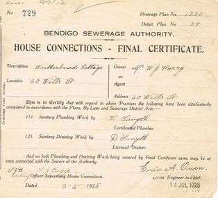
Document - BENDIGO SEWERAGE AUTHORITY : HOUSE CONNECTIONS - FINAL CERTIFICATE : 6 APRIL 1925, 06/04/1925
Bendigo Sewerage Authority. House Connections - Final Certificate. Dated 6/4/1925. A small document pertaining to 60 Wills St. Owner: Mr W. J. Parry. No. 729, Drainage plan No. 1220, Detail Plan No. 39. Description: weatherboard cottage. Four people have signed the form: V. Smyth (certified plumber), D. Smyth (licensed drainer), S. J. Beggs (officer supervising house connections), and Eric A. Owen (acting Engineer in Chief). The form is stamped 14 Jul 1925.bendigo, utilities, bendigo sewerage authority. owen, eric a. smyth v. smyth d. beggs, s. j. 60 wills st, bendigo. -
 Bendigo Historical Society Inc.
Document - The Flooded Mine, John McCaviston's Escape, April, 2014
Seven men were killed at the Great Extended Hustler's mine disaster on 2nd May 1914 by an explosion of dynamite occurring as the men were waiting at the plat to ascend the mine at the end of their shift. No blame was attached to anyone in the findings of the inquisition. It was unknown what caused the dynamite to explode. Three page typed document by Albert Richardson. Copy of handwritten document. 'The Flooded Mine, John McCaviston's Wonderful Escape' by G. Mackay (History of Bendigo). Article details the events that surrounded the flooding that occurred at the Hustlers Reef Company's mine on 13th December 1873. Water was being drained from the adjoining old workings of Latham and Watson, when the flow increased markedly, causing flooding. John McCaviston was the 'shift boss'., R. Jackson the Manager. McCaviston was saved after spending over 20 hours in a level.3527.2 on bottom of all pages. Duplicate copy. great extended hustlers, goldmining, accident, quartz, mining, flooding of mine, john mccaviston, mine rescue, r. jackson, latham and watson -
 Eltham District Historical Society Inc
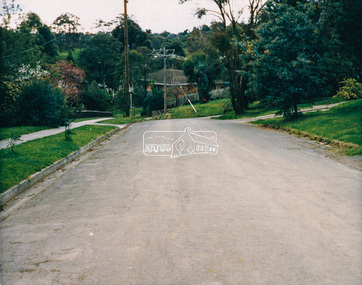
Photograph - Colour Print, Eltham Shire Council, Unidentified road, Eltham district, c.Oct. 1987
Date based on other similar display panels visible in images of the Shire of Eltham display at the Eltham Community Festival, 7 November 1987. 20 x 25 cm Shire of Eltham Engineering Department Providing the resources to undertake • Survey, design, consultation • Road construction and maintenance • Bridge construction and maintenance • Street sweeping • Drain and pit cleaning • Traffic engineering installation and maintenance • Garbage collection • Tip management, land reclamation and beautification • Maintenance of community buildings • Provision of community and recreation facilitiesunidentified, display panel, eltham festival, footpaths and gutters, infrastructure, residential, roads, shire of eltham, streets, 1987 -
 Eltham District Historical Society Inc
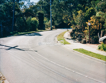
Photograph - Colour Print, Eltham Shire Council, Unidentified road, Eltham district, c.Oct. 1987
Date based on other similar display panels visible in images of the Shire of Eltham display at the Eltham Community Festival, 7 November 1987. 20 x 25 cm Shire of Eltham Engineering Department Providing the resources to undertake • Survey, design, consultation • Road construction and maintenance • Bridge construction and maintenance • Street sweeping • Drain and pit cleaning • Traffic engineering installation and maintenance • Garbage collection • Tip management, land reclamation and beautification • Maintenance of community buildings • Provision of community and recreation facilitiesunidentified, display panel, eltham festival, footpaths and gutters, infrastructure, residential, roads, shire of eltham, streets, 1987 -
 Eltham District Historical Society Inc
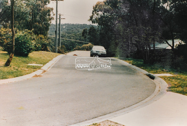
Photograph - Colour Print, Eltham Shire Council, Unidentified road, Eltham district, c.Oct. 1987
Date based on other similar display panels visible in images of the Shire of Eltham display at the Eltham Community Festival, 7 November 1987. 20 x 25 cm Shire of Eltham Engineering Department Providing the resources to undertake • Survey, design, consultation • Road construction and maintenance • Bridge construction and maintenance • Street sweeping • Drain and pit cleaning • Traffic engineering installation and maintenance • Garbage collection • Tip management, land reclamation and beautification • Maintenance of community buildings • Provision of community and recreation facilitiesunidentified, display panel, eltham festival, footpaths and gutters, infrastructure, residential, roads, shire of eltham, streets, 1987 -
 Puffing Billy Railway
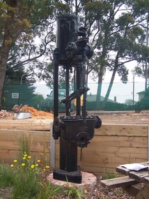
Vertical Pump, Weir, 1948
Weir Pumps - these types of vertical pumps were used extensively with both land and marine steam pumps. The pumps were also used for various duties from pumping oil fuel and feed water for boilers, to draining bilges on steam ship[s They are a single cylinder, double acting vertical pumps used by G. & J. Weir Ltd. , of Cathcart, Glasgow The large pump serial number 231703 was built in 1948 and worked at the old Victoria Brewery in East Melbourne before coming to the Museum in 1985. Historic - Weir Vertical Pump used at the old Victoria Brewery in East Melbourne The large pump serial number 231703 was built in 1948 and worked at the old Victoria Brewery in East Melbourne before coming to the Museum in 1985.Weir Vertical Pump - Large Steel PumpWeir puffing billy, weir vertical pump, victoria brewery -
 Warrnambool and District Historical Society Inc.
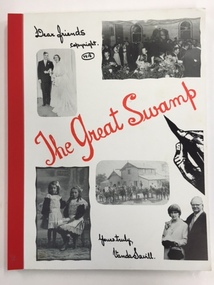
Book, The Great Swamp, 1980s
This book has been written by Vanda Savill and is about the settlers in the Wallacedale area in Western Victoria. Wallacedale is 28 kilometres south west of Hamilton and was created by the draining of the Condah Swamp. Vanda Savill (1913-2005) and her husband ran a dairy farm and the Bower Birds Nest Museum and History Centre at Heywood. Vanda Savill was passionate about keeping alive the personal histories of local people and for 20 years she wrote and published many books about the areas in which she lived. This book is of interest because it tells the stories of settlers in the Wallacedale area of Western Victoria. It also has appeal because of the warm, conversational style of the author.This is a soft cover book of 216 pages. The cover has a white background with a black and white image of a hand holding a pen and, on the front cover, five black and white photographs and, on the back cover, nine black and white photographs. The title of the book is in red cursive writing. The information in the book is printed from the original handwriting of the author (Vanda Savill). The book also has many black and white photographs. The book is bound with red tape.wallacedale, history of western victoria, vanda savill, warrnambool -
 Eltham District Historical Society Inc
Photograph, Looking west from Main Road from just north of intersection with Diamond Street, Eltham, February 1968, Feb 1968
The watercourse passes under the road and railway at this point. Significant flash flooding occurred along this water course on Christmas Day 2011 causing significant damage to the railway line and road and flooding of Judge Book Village. The drain was swept away including the support pillars of the rail lines timber framework. Judge Book Village had some 40 units flooded before the water entered Diamond Creek. The water had flowed down and flooded Valonia Drive then Grove Street before flowing down the watercourse to Main RoadIn February 1968 an unknown person took a series of photos from the Eltham Hotel at Pitt Street heading north along Main Road through the shopping centre to just north of Elsa Court covering the length of the section of Main Road which was duplicated shortly thereafter. Shows the condition and environment of the streesscape of Main Road, Eltham immediately prior to the duplication between Pitt Street and Elsa Court through the shopping centre. Also shows a number of shops and businesses that operated at that time.Black and white photographduplication, eltham, main road, diamond street, watercourse, drainage, railway line -
 Melbourne Water
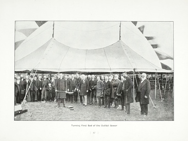
Photograph - Turning Of The First Sod, 1908
The 19th of May marks the anniversary of the turning of the first sod of the outfall sewer. In 1888, a Royal Commission into Melbourne’s public health led to an ambitious plan to construct a sewerage system of underground pipes, sewers and drains to carry sewage from homes and factories to a sewage treatment farm. The commission also supported the establishment of the Melbourne Metropolitan Board of Works (MMBW), the authority that would build the sewerage system and manage Melbourne’s water supply. This photograph is from The Melbourne and Metropolitan Board of Works Water Supply, Sewerage, and etc Photographic Views, 1908This photograph is in excellent condition and provides a detailed insight into Board personnel of the MMBW. It is of historical importance to the history of Melbourne in the turning of the very first sod.Black and white photographphotograph, mmbw, melbourne metropolitan board of works, melbourne water, historic, turniing of the first sod, book, sewerage, water -
 Orbost & District Historical Society
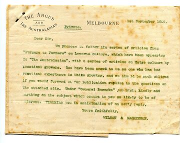
letter, September 1 1909
When early settlers began to arrive on the Snowy River somewhere in the 1880s, the land was mostly swamps and heavily timbered jungle on the river frontages. The swamps were drained bit by bit using hand tools. The frontages were cleared by axe and shovel and fire. Several kinds of crops were experimented with such as hops, hemp and maize. Maize grew particularly well and became the main crop of the district. (info. from October 2006 ODHS Newsletter) The Argus was a morning daily newspaper in Melbourne, Australia that was established in 1846 and closed in 1957. It was considered to be the general Australian newspaper of record for this period.Maize-growing has been an important agricultural industry in the Orbost district since early settlement. This item is associated with that history.A typed letter sent to a local maize farmer requesting information on maize growing. The letter has the "Argus" letter head. The name of the recipient is unknown.maize agriculture-orbost correspondence-argus -
 City of Moorabbin Historical Society (Operating the Box Cottage Museum)
Kitchen equipment, butter pats wooden, c1880
Early settlers had to be self sufficient, growing their own vegetables, making tools and clothing and usually had a house cow to produce their milk supply. .All the buttermilk separated from the butterfat had to be rinsed out. This would improve texture and flavour, and also help the butter keep well, since milk turns rancid more quickly than fat alone. Salt was usually mixed in at this stage - for flavour and preservation. The rinsing could be done simply by washing in water, followed by draining, salting and working or "kneading" the butter with a pair of wooden butter pats, or with bare hands. c1880 A pair of wooden butter patspioneers, early settlers, market gardeners, moorabbin, brighton, bentleigh, cheltenham, milk, dairy farmers, butter pats, dairy cows -
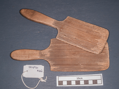 City of Moorabbin Historical Society (Operating the Box Cottage Museum)
Kitchen Equipment, butter pats wooden, c1880
Early settlers had to be self sufficient, growing their own vegetables, making tools and clothing and usually had a house cow to produce their milk supply. .All the buttermilk separated from the butterfat had to be rinsed out. This would improve texture and flavour, and also help the butter keep well, since milk turns rancid more quickly than fat alone. Salt was usually mixed in at this stage - for flavour and preservation. The rinsing could be done simply by washing in water, followed by draining, salting and working or "kneading" the butter with a pair of wooden butter pats, or with bare hands. c1880 2 wooden butter patsearly settlers, pioneers, market gardeners, moorabbin, bentleigh, brighton, cheltenham, dairy farmers, dairy cows, milk, butter -
 Orbost & District Historical Society
black and white photograph, 1884?
James Alexander Robertson was born 14th June, 1855, at Pentridge. the Coburg area which was known as Pentridge at the time, and prior to the building of the gaol. His parents were James Thomson Robertson and Esther (nee Hale), At age 20 James became the first selector on the Snowy River at Lochend. He took up Lots 1, 2 and 3, in the Parish of Newmerella in 1875; with his selection being ratified on May 1st, 1876. The selection included hill and river flat land in the area near where Icy Creek enters the Snowy River. James gradually improved and farmed the property; he cleared and drained Icy Creek and constructed the first known flood-gate on the Snowy River. To meet his farming commitments he supplemented his income by working on the construction and maintenance of roads and drains in the Newmerella area. He gained a contract with the Bairnsdale Shire council to construct the first road cutting down Burn’s Hill at Newmerella. His tender was for £16 ($32), and it took him, with four others, two months to complete the contract. He was single, and, after his untimely death at aged 29, in 1884, his parents and surviving unmarried sisters and brothers moved from Sarsfield to take over his selection at Lochend. (more information Newsletter April 2013)James Robertson was the first selector of land at Lochend, Orbost.A small black / white portrait photograph, oval shaped with a white background. It is of a middle-aged man with a full beard and moustache.on front at bottom - typed in black -:"James Alexander Robertson, Late of Lochend, Snowy River"robertson-james-alexander lochend-robertson -
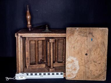 City of Moorabbin Historical Society (Operating the Box Cottage Museum)
Churn, small domestic butter, c1880
A butter churn is a device used to convert cream into butter. This is done through a mechanical process, via a crank used to manually turn a rotating device inside the barrel shaped churn. The agitation of the cream, caused by the mechanical motion of the device, disrupts the milk fat. The membranes that surround the fats are broken down, subsequently forming clumps known as butter grains. These butter grains, during the process of churning, fuse with each other and form larger fat globules. Air bubbles are introduced into these fat globules via the continued mechanical action of the churn. The butter grains become more dense as fat globules attach to them while the air is forced out of the mixture. This process creates a liquid known as buttermilk. With constant churning, the fat globules eventually form solid butter and separate from the buttermilk. The buttermilk is then drained off and the butter is squeezed to eliminate excess liquid and to form it into a solid mass. Then rinsing could be done simply by washing in water, followed by draining, salting and working or "kneading" the butter with a pair of wooden butter pats, or with bare hands. This is a paddle churn, a barrel that contains a paddle, which is operated by a handle. The paddle churned the butter inside the container when the handle was turned. Early settlers had to be self sufficient, growing their own vegetables, making tools and clothing and usually had a house cow to produce their milk supplyThis domestic butter churn is an example of the skill of the pioneer craftsman, carpenters and tool makers c1900. As pioneers and early settlers had to be self sufficient they usually kept a dairy cow or 'house cow' to provide milk for drinking and for butter and cheese to made by the family.A small wooden, domestic butter churn with a lid and a crank that manually rotated the paddle inside. E. CHERRY / MAKER / GISBORNE / VICTORIA / Apioneers, early settlers, market gardeners, moorabbin, brighton, cheltenham, dairy products. dairy farmers, milk, butter, dairies -
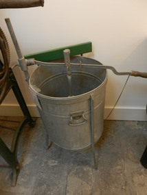 Whitehorse Historical Society Inc.
Machine - Washing Machine
Hand operated washing machine - plunger type - a central cone plunger attached to a fulcrum point (adjustable in height) on side with a long arm. Depth of plunger action also adjustable. All mounted on a three leg frame. Container is slightly coned shaped at bottom and has a drain tap at bottom for emptying water. Container can also be lifted off. Provision made for attachment of a wringer (this could be a later modification). Plunger is approx 37cm in diameter and has four 1.5cm holes for water to be forced through. Unit is galvanised steel but frame appears to have been painted with 'Silverfros'.On Side of container - 'The Zwar' VACUUM Washing Machine Patent No 2089/31domestic items, laundering -
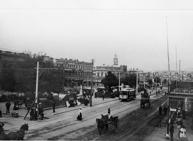 Ballarat Tramway Museum
Photograph - Black & White Photograph/s, c1907
Yields information the operation of horse trams in Sebastopol, the condition of the streets at the time, the nature of the buildings and streetscape.Black and White photograph of a north bound tram in Albert St Sebastopol. The tram has just crossed Albert St and is approaching Bridge St. Note the streetscape, the open drains and shopping strip. The tram has a roof advertisement for Havelock tobacco as does the Grocer shop in the background. See Reg Item 1090 for another copy of this photograph, with Christmas Greetings along the top edge. Used in "The Golden City and its Tramways", page 32, credited to Harris House of Photography. Hi Res image added 16-12-2015. See The Golden City and its Tramwaystramways, trams, albert st, horse trams, sebastopol -
Maldon Vintage Machinery Museum Inc
Steam Engine, 1877
Restored by Maldon Flywheelers Association. Originally owned and used by Zemster Brothers of "Brook Mount" Shellbourne.Known as "Aunty Jack"Large 4 wheeled 9 HP single cylinder (horizontal) steam engine, designed to be towed. Front wheels smaller than rear. Folding smoke stack with spark arrestor. Fire box and smoke stack painted black, boiler and steam cylinder green, wheels grey. In working order but engine is connected to an independent steam/air source to be operated for display purposes. 150 cm flywheel on LHS looking forward toward the front. Timber front turntable and back brake pad assembly. Brass water drain tap on firebox. Also other brass fittings on firebox.On brass ring near top of firebox:- "Serial No. 5672, Marshal Sons & Co. / Limited / Engineers / Gainsborough England". Metal plate on front turntable:- "Restoration of the Front Undercarriage / and retubing of the boiler by / Castlemaine Technical School / 1979". Cast in relief on wheel hubs:- "Marshal Sons & Co. Gainsborough".machinery - engines - steam -
 Kew Historical Society Inc
Plan, Melbourne & Metropolitan Board of Works : Borough of Kew : Detail Plan No.1576, 1904
The Melbourne and Metropolitan Board of Works (MMBW) plans were produced from the 1890s to the 1950s. They were crucial to the design and development of Melbourne's sewerage and drainage system. The plans, at a scale of 40 feet to 1 inch (1:480), provide a detailed historical record of Melbourne streetscapes and environmental features. Each plan covers one or two street blocks (roughly six streets), showing details of buildings, including garden layouts and ownership boundaries, and features such as laneways, drains, bridges, parks, municipal boundaries and other prominent landmarks as they existed at the time each plan was produced. (Source: State Library of Victoria)This plan forms part of a large group of MMBW plans and maps that was donated to the Society by the Mr Poulter, City Engineer of the City of Kew in 1989. Within this collection, thirty-five hand-coloured plans, backed with linen, are of statewide significance as they include annotations that provide details of construction materials used in buildings in the first decade of the 20th century as well as additional information about land ownership and usage. The copies in the Public Record Office Victoria and the State Library of Victoria are monochrome versions which do not denote building materials so that the maps in this collection are invaluable and unique tools for researchers and heritage consultants. A number of the plans are not held in the collection of the State Library of Victoria so they have the additional attribute of rarity.Original survey plan, issued by the MMBW to a contractor with responsibility for constructing sewers in the area identified on the plan within the Borough of Kew. The plan was at some stage hand-coloured, possibly by the contractor, but more likely by officers working in the Engineering Department of the Borough and later Town, then City of Kew. The hand-coloured sections of buildings on the plan were used to denote masonry or brick constructions (pink), weatherboard constructions (yellow), and public buildings (grey). Development in the 20th century has irreparably altered that part of Kew represented in this plan. In the block bounded by Cotham Road, Charles Street, Wellington Street and Gellibrand; just one house standing in 1903 remains. This block included two of the most historic houses in Kew: ‘Ordsall’ (later ‘Southesk’) and ‘Madford’ (previously ‘Elm Lodge’). Ordsall was the home of the second chairman of Kew, John Halfey. It contained some of the most significant interior murals in Kew, created for Halfey by artists working for Cullen & Co. It was demolished in 1960 to make way for the Kew Civic Centre. Elm Lodge had been built for William Siddeley in ca. 1864. Arthur Septimus King purchased it in 1874. The lower paddocks of Madford were sold in 1905 by his wife to the Borough of Kew and, after landscaping by George and Thomas Pockett, opened as the Alexandra Gardens in 1908. Elm Lodge/Madford was in 1922 to become St. Anthony’s Home for Little Children before its subsequent demolition in the 1980s.melbourne and metropolitan board of works, detail plans, maps - borough of kew, mmbw 1576, cartography -
 Kew Historical Society Inc
Plan, Borough of Kew Detail Plan No.1577, 1904
The Melbourne and Metropolitan Board of Works (MMBW) plans were produced from the 1890s to the 1950s. They were crucial to the design and development of Melbourne's sewerage and drainage system. The plans, at a scale of 40 feet to 1 inch (1:480), provide a detailed historical record of Melbourne streetscapes and environmental features. Each plan covers one or two street blocks (roughly six streets), showing details of buildings, including garden layouts and ownership boundaries, and features such as laneways, drains, bridges, parks, municipal boundaries and other prominent landmarks as they existed at the time each plan was produced. (Source: State Library of Victoria)This plan forms part of a large group of MMBW plans and maps that was donated to the Society by the Mr Poulter, City Engineer of the City of Kew in 1989. Within this collection, thirty-five hand-coloured plans, backed with linen, are of statewide significance as they include annotations that provide details of construction materials used in buildings in the first decade of the 20th century as well as additional information about land ownership and usage. The copies in the Public Record Office Victoria and the State Library of Victoria are monochrome versions which do not denote building materials so that the maps in this collection are invaluable and unique tools for researchers and heritage consultants. A number of the plans are not held in the collection of the State Library of Victoria so they have the additional attribute of rarity.Original survey plan, issued by the MMBW to a contractor with responsibility for constructing sewers in the area identified on the plan within the Borough of Kew. The plan was at some stage hand-coloured, possibly by the contractor, but more likely by officers working in the Engineering Department of the Borough and later Town, then City of Kew. The hand-coloured sections of buildings on the plan were used to denote masonry or brick constructions (pink), weatherboard constructions (yellow), and public buildings (grey). MMBW Plan No.1577 includes some of the most significant houses in Kew: Herbert Henty’s ‘Roxeth’ (now part of Trinity Grammar), ‘Butleigh Wooton’, ‘Bokara’ and ‘Harrow’. It also includes the streets that have since changed their names. That part of College Parade linked to Glenferrie Road is now named College Place, College Parade now extends further north, and Charles Street did not yet reach Barkers Road. Roxeth is one of a number of Henty houses in Kew. Herbert Henty made his home here and was elected a member of Kew Municipal Council in 1864 and mayor in 1868-69. Walter Henry Serle, of Harrow served in the First World War. He was awarded the Military Medal ‘’For conspicuous bravery and devotion to duty. On 29th September near BELLICOURT he showed the greatest bravery and determination when his platoon was attacked by enemy bombing parties. It was due largely to his personal efforts that all the attacks were repulsed. Until wounded, his utter disregard of personal safety and boldness in dealing with the attacks were the means of saving the situation and were an inspiring example to his men.’melbourne and metropolitan board of works, detail plans, maps - borough of kew, mmbw 1577, cartography -
 Kew Historical Society Inc
Plan, Melbourne & Metropolitan Board of Works : Borough of Kew : Detail Plan No.1578, 1904
The Melbourne and Metropolitan Board of Works (MMBW) plans were produced from the 1890s to the 1950s. They were crucial to the design and development of Melbourne's sewerage and drainage system. The plans, at a scale of 40 feet to 1 inch (1:480), provide a detailed historical record of Melbourne streetscapes and environmental features. Each plan covers one or two street blocks (roughly six streets), showing details of buildings, including garden layouts and ownership boundaries, and features such as laneways, drains, bridges, parks, municipal boundaries and other prominent landmarks as they existed at the time each plan was produced. (Source: State Library of Victoria). This plan forms part of a large group of MMBW plans and maps that was donated to the Society by the Mr Poulter, City Engineer of the City of Kew in 1989. Within this collection, thirty-five hand-coloured plans, backed with linen, are of statewide significance as they include annotations that provide details of construction materials used in buildings in the first decade of the 20th century as well as additional information about land ownership and usage. The copies in the Public Record Office Victoria and the State Library of Victoria are monochrome versions which do not denote building materials so that the maps in this collection are invaluable and unique tools for researchers and heritage consultants. A number of the plans are not held in the collection of the State Library of Victoria so they have the additional attribute of rarity.Original survey plan, issued by the MMBW to a contractor with responsibility for constructing sewers in the area identified on the plan within the Borough of Kew. The plan was at some stage hand-coloured, possibly by the contractor, but more likely by officers working in the Engineering Department of the Borough and later Town, then City of Kew. The hand-coloured sections of buildings on the plan were used to denote masonry or brick constructions (pink), weatherboard constructions (yellow), and public buildings (grey). MMBW Plan No.1578 is significant in that it defines the extent of two private schools: Xavier College and Kew High School (now part of Trinity Grammar) by 1904. In relation to the latter, the plan clarifies which buildings the High School operated from behind the mansion ‘Molina’. Established in 1902, Trinity Grammar was to later lease and subsequently buy Molina (now ‘Merritt House’) and ‘Elsinore’ (now ‘Roberts House’). Xavier College had been established in 1872. This 1904 plan delineates the West Wing and the Great Hall (built in 1890).melbourne and metropolitan board of works, detail plans, maps - borough of kew, mmbw 1578, cartography -
 Kew Historical Society Inc
Plan, Melbourne & Metropolitan Board of Works. Borough of Kew Detail Plan No.1579, 1904
The Melbourne and Metropolitan Board of Works (MMBW) plans were produced from the 1890s to the 1950s. They were crucial to the design and development of Melbourne's sewerage and drainage system. The plans, at a scale of 40 feet to 1 inch (1:480), provide a detailed historical record of Melbourne streetscapes and environmental features. Each plan covers one or two street blocks (roughly six streets), showing details of buildings, including garden layouts and ownership boundaries, and features such as laneways, drains, bridges, parks, municipal boundaries and other prominent landmarks as they existed at the time each plan was produced. (Source: State Library of Victoria). This plan forms part of a large group of MMBW plans and maps that was donated to the Society by the Mr Poulter, City Engineer of the City of Kew in 1989. Within this collection, thirty-five hand-coloured plans, backed with linen, are of statewide significance as they include annotations that provide details of construction materials used in buildings in the first decade of the 20th century as well as additional information about land ownership and usage. The copies in the Public Record Office Victoria and the State Library of Victoria are monochrome versions which do not denote building materials so that the maps in this collection are invaluable and unique tools for researchers and heritage consultants. A number of the plans are not held in the collection of the State Library of Victoria so they have the additional attribute of rarity.Original survey plan, issued by the MMBW to a contractor with responsibility for constructing sewers in the area identified on the plan within the Borough of Kew. The plan was at some stage hand-coloured, possibly by the contractor, but more likely by officers working in the Engineering Department of the Borough and later Town, then City of Kew. The hand-coloured sections of buildings on the plan were used to denote masonry or brick constructions (pink), weatherboard constructions (yellow), and public buildings (grey). While MMBW Plan No.1579 does not include many buildings, those that it does show are significant to Kew’s history. These include the ‘Kew [Railway] Station’ in Denmark Street and the ‘Recreation Hall’ and rear courts off Wellington Street. The plan shows the outline of the Recreation Hall, constructed in 1880, at the rear of which is listed a bowling green, two tennis courts, a ‘skittle alley’ and a pavilion. When the Hall was first built, the Kew Cricket Club occupied an adjacent ground, however in 1885 this was acquired by the State Government as the future location of the Kew Railway Station. The Plan also shows a single oval at Xavier College. This oval was completed in 1883. One of the current ovals conforms to this oval’s original shape and position in the school grounds.melbourne and metropolitan board of works, detail plans, maps - borough of kew, mmbw 1579, cartography -
 Kew Historical Society Inc
Plan, Melbourne and Metropolitan Board of Works, Borough of Kew : Detail Plan No.1580, 1904
The Melbourne and Metropolitan Board of Works (MMBW) plans were produced from the 1890s to the 1950s. They were crucial to the design and development of Melbourne's sewerage and drainage system. The plans, at a scale of 40 feet to 1 inch (1:480), provide a detailed historical record of Melbourne streetscapes and environmental features. Each plan covers one or two street blocks (roughly six streets), showing details of buildings, including garden layouts and ownership boundaries, and features such as laneways, drains, bridges, parks, municipal boundaries and other prominent landmarks as they existed at the time each plan was produced. (Source: State Library of Victoria)This plan forms part of a large group of MMBW plans and maps that was donated to the Society by the Mr Poulter, City Engineer of the City of Kew in 1989. Within this collection, thirty-five hand-coloured plans, backed with linen, are of statewide significance as they include annotations that provide details of construction materials used in buildings in the first decade of the 20th century as well as additional information about land ownership and usage. The copies in the Public Record Office Victoria and the State Library of Victoria are monochrome versions which do not denote building materials so that the maps in this collection are invaluable and unique tools for researchers and heritage consultants. A number of the plans are not held in the collection of the State Library of Victoria so they have the additional attribute of rarity.Original survey plan, issued by the MMBW to a contractor with responsibility for constructing sewers in the area identified on the plan within the Borough of Kew. The plan was at some stage hand-coloured, possibly by the contractor, but more likely by officers working in the Engineering Department of the Borough and later Town, then City of Kew. The hand-coloured sections of buildings on the plan were used to denote masonry or brick constructions (pink), weatherboard constructions (yellow), and public buildings (grey). The area represented in this detail plan has undergone significant change during the 20th century. The widening of High Street in the 1930s and 1950s involved the shops on the south side of High Street being demolished and later rebuilt to fit the widened street. Another significant loss was the mansion ‘Drayton’ fronting Wellington Street, owned at this stage by Susannah Fenton. Her family name would later to be given to Fenton Way, which was to be built over the grounds of the house following its demolition. The plan of the garden is particularly interesting, containing a batten dome fronting Wellington Street, an ornamental pond, a fountain and a brick and glass conservatory. The notes by the plumbing contractor on this plan are particularly detailed. Pink borders delineate the ownership of the varying parcels of land. Some of the better known owners listed include the real estate agent Cr. Henry de Castres Kellett (bt) and John Padbury, the funeral director. This particular plan provides a clear view of the configuration of the Kew Junction in 1903 and the commercial buildings that surrounded it.melbourne and metropolitan board of works, detail plans, maps - borough of kew, mmbw 1580, cartography -
 Kew Historical Society Inc
Plan, Melbourne & Metropolitan Board of Works : Borough of Kew : Detail Plan No.1581, 1904
The Melbourne and Metropolitan Board of Works (MMBW) plans were produced from the 1890s to the 1950s. They were crucial to the design and development of Melbourne's sewerage and drainage system. The plans, at a scale of 40 feet to 1 inch (1:480), provide a detailed historical record of Melbourne streetscapes and environmental features. Each plan covers one or two street blocks (roughly six streets), showing details of buildings, including garden layouts and ownership boundaries, and features such as laneways, drains, bridges, parks, municipal boundaries and other prominent landmarks as they existed at the time each plan was produced. (Source: State Library of Victoria)This plan forms part of a large group of MMBW plans and maps that was donated to the Society by the Mr Poulter, City Engineer of the City of Kew in 1989. Within this collection, thirty-five hand-coloured plans, backed with linen, are of statewide significance as they include annotations that provide details of construction materials used in buildings in the first decade of the 20th century as well as additional information about land ownership and usage. The copies in the Public Record Office Victoria and the State Library of Victoria are monochrome versions which do not denote building materials so that the maps in this collection are invaluable and unique tools for researchers and heritage consultants. A number of the plans are not held in the collection of the State Library of Victoria so they have the additional attribute of rarity.Original survey plan, issued by the MMBW to a contractor with responsibility for constructing sewers in the area identified on the plan within the Borough of Kew. The plan was at some stage hand-coloured, possibly by the contractor, but more likely by officers working in the Engineering Department of the Borough and later Town, then City of Kew. The hand-coloured sections of buildings on the plan were used to denote masonry or brick constructions (pink), weatherboard constructions (yellow), and public buildings (grey). The streets and built structures in this plan were surveyed in 1903 and released to contractors in 1904. In addition to the designation of building types by colour, the plan includes detailed descriptions of land use and ownership. While many buildings remain from this period, a number of the buildings represented have been demolished including the original Kew Town Hall, and the Congregational and Roman Catholic churches in Walpole Street. While the mansion ‘Illapa’ in Princess Street is still extant – now part of ‘Rylands’ – the neighbouring mansion ‘Elsmere’ was demolished some decades ago. Rivalling Illapa and Elsmere in size were two mansions in Walpole Street, one named on the plan as ‘Gnarlbine’. Over time, Kew Junction and the south side of High Street have been reconfigured and widened, so that the commercial buildings on the corner of Princess and High Street no longer exist. A surprising feature of this part of central Kew to the northwest of Kew Junction is the amount of vacant land. In a number of cases, this land is noted by the contractor as used for vegetable gardens.melbourne and metropolitan board of works, detail plans, maps - borough of kew, mmbw 1581, cartography -
 Kew Historical Society Inc
Plan, Melbourne & Metropolitan Board of Works : Borough of Kew : Detail Plan No.1582, 1904
The Melbourne and Metropolitan Board of Works (MMBW) plans were produced from the 1890s to the 1950s. They were crucial to the design and development of Melbourne's sewerage and drainage system. The plans, at a scale of 40 feet to 1 inch (1:480), provide a detailed historical record of Melbourne streetscapes and environmental features. Each plan covers one or two street blocks (roughly six streets), showing details of buildings, including garden layouts and ownership boundaries, and features such as laneways, drains, bridges, parks, municipal boundaries and other prominent landmarks as they existed at the time each plan was produced. (Source: State Library of Victoria)This plan forms part of a large group of MMBW plans and maps that was donated to the Society by the Mr Poulter, City Engineer of the City of Kew in 1989. Within this collection, thirty-five hand-coloured plans, backed with linen, are of statewide significance as they include annotations that provide details of construction materials used in buildings in the first decade of the 20th century as well as additional information about land ownership and usage. The copies in the Public Record Office Victoria and the State Library of Victoria are monochrome versions which do not denote building materials so that the maps in this collection are invaluable and unique tools for researchers and heritage consultants. A number of the plans are not held in the collection of the State Library of Victoria so they have the additional attribute of rarity.Original survey plan, issued by the MMBW to a contractor with responsibility for constructing sewers in the area identified on the plan within the Borough of Kew. The plan was at some stage hand-coloured, possibly by the contractor, but more likely by officers working in the Engineering Department of the Borough and later Town, then City of Kew. The hand-coloured sections of buildings on the plan were used to denote masonry or brick constructions (pink), weatherboard constructions (yellow), and public buildings (grey). Public buildings, coloured grey on the Plan 1582 include the police station and post office, churches and schools. The earliest church school, Common School No.356 was located at the rear of the Congregational Church in Peel Street. It was constructed in 1859. The first buildings of Kew Primary School No.1075 on the other side of Peel Street were constructed in 1871. The school in 1903 only occupied a small fraction of its current site. In 1903, where the rear playground is now located, were two weatherboard and one brick villa. Trinity Grammar School was founded in 1902 and opened in the Parish Hall at the rear of Holy Trinity Anglican Church. It was not to move to its current site until 1906. The outline of the building housing the Kew Fire Brigade in the centre of the north side of Walton Street is shown but not named on the plan. Further down Pakington Street stood the two-storey Italianate mansion ‘Overton’. The home of Stanford Chapman, it was to be featured in the Imperial Institute series of bromide photographs of Victoria, Vol. 1: Homes and scenery. It was later to become a boarding house before it was later demolished.melbourne and metropolitan board of works, detail plans, maps - borough of kew, mmbw 1582, cartography -
 Kew Historical Society Inc
Plan, Melbourne & Metropolitan Board of Works : Borough of Kew : Detail Plan No.1585, 1904
The Melbourne and Metropolitan Board of Works (MMBW) plans were produced from the 1890s to the 1950s. They were crucial to the design and development of Melbourne's sewerage and drainage system. The plans, at a scale of 40 feet to 1 inch (1:480), provide a detailed historical record of Melbourne streetscapes and environmental features. Each plan covers one or two street blocks (roughly six streets), showing details of buildings, including garden layouts and ownership boundaries, and features such as laneways, drains, bridges, parks, municipal boundaries and other prominent landmarks as they existed at the time each plan was produced. (Source: State Library of Victoria)This plan forms part of a large group of MMBW plans and maps that was donated to the Society by the Mr Poulter, City Engineer of the City of Kew in 1989. Within this collection, thirty-five hand-coloured plans, backed with linen, are of statewide significance as they include annotations that provide details of construction materials used in buildings in the first decade of the 20th century as well as additional information about land ownership and usage. The copies in the Public Record Office Victoria and the State Library of Victoria are monochrome versions which do not denote building materials so that the maps in this collection are invaluable and unique tools for researchers and heritage consultants. A number of the plans are not held in the collection of the State Library of Victoria so they have the additional attribute of rarity.Original survey plan, issued by the MMBW to a contractor with responsibility for constructing sewers in the area identified on the plan within the Borough of Kew. The plan was at some stage hand-coloured, possibly by the contractor, but more likely by officers working in the Engineering Department of the Borough and later Town, then City of Kew. The hand-coloured sections of buildings on the plan were used to denote masonry or brick constructions (pink), weatherboard constructions (yellow), and public buildings (grey). This plan, which covers parts of High Street, Pakington Street and Derby Street is dominated by two historic Kew mansions: ‘Konetta’ and ‘Ramornie’. Ramornie was constructed in 1890 for James Maitland Campbell, three times Mayor of Kew. Sold in 1940, it became a boarding house known as ‘The Towers’. Now a private residence again, it has only one of its three balconies remaining. The location of the missing two balconies can be seen on the plan. In 1903, the grounds of Ramornie included a large tennis court fronting Pakington Street. The rear of the property is shown as extending to Cobden Street. One of Kew’s oldest hotels, the Prospect Hill Hotel on the corner of High and Cobden Street was established in 1858. The outline of the hotel shown on the plan represents the second building on the site. During the 19th century it was often used for electoral meetings. The Prospect Hill Hotel was to be redeveloped again in 1928, by the local architect Robert McIntyre. Since the 1980s, the hotel has been a live music venue, the home of the Melbourne Jazz Club, a restaurant and a liquor outlet.melbourne and metropolitan board of works, detail plans, maps - borough of kew, mmbw 1585, cartography