Showing 1371 items
matching east side
-
 B-24 Liberator Memorial Restoration Australia Inc
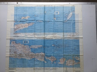
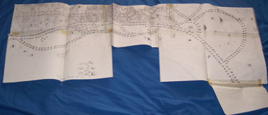
Map - US World War II-coloured map, - Southwest Pacific Area, No.22 Southwestern, No.26 East Java, No.25 Timor, 1943
... Southwestern and No. 26 East Java Side 2 - No. 25 Timor... Southwestern and No. 26 East Java Side 2 - No. 25 Timor A multi ...Silk and rayon maps were produced by the United States (c. 7.5 million in total), Great Britain (some 1.75 million in total) and Australia during World War II. They were issued to Allied military personnel as part of 'escape and evasion' kits.This map, printed on acetate rayon, is an original US 'escape and evasion' kit map from World War II.A multi-coloured, contoured, double-sided map printed on acetate rayon AAF Cloth Map - Southwest Pacific Area Side 1 - No. 22 Southwestern and No. 26 East Java Side 2 - No. 25 Timorworld war ii, silk maps, united states of america, a188 -
 Ringwood and District Historical Society
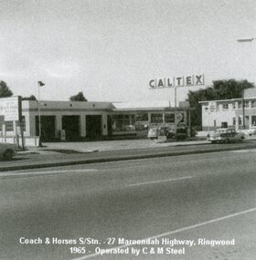
Photograph, Coach & Horses Service Station, 27 Maroondah Highway, Ringwood in 1965
... Hotel on east (right-hand) side.... Hotel on east (right-hand) side. Coach & Horses Service Station ...Owned and run by Colin Steel. Showing the Coach & Horses Hotel on east (right-hand) side. -
 Charlton Golden Grains Museum Inc
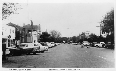
Photograph - Postcard, Jone's Newsagency, Shopping Centre, Charlton. Vic, c.1950
... Bank. On the RH side - East Charlton Hotel, Globe Hotel,. Fire... bank, State Bank. On the RH side - East Charlton Hotel, Globe... Bank. On the RH side - East Charlton Hotel, Globe Hotel,. Fire ...Postcard part of a set of photos of Charlton buildings c. 1950 produced for sale at Jones Newsagency.. Businesses on the LH side - Kitchin/Kerrs Garage, Post Office, ANZ Bank, State Bank. On the RH side - East Charlton Hotel, Globe Hotel,. Fire station at far end of High Street.Postcard showing High St Charlton looking west. Cars parked on both sides of the street and several cars driving toward photographer. Woman walking past Holden dealership. Mobil Service sign. Businesses on the LH side - Kitchin/Kerrs Garage, Post Office, ANZ bank, State Bank. On the RH side - East Charlton Hotel, Globe Hotel,. Fire station at far end of High Street.Shopping Centre, Charlton. Vic. The Rose Series P. 2743kitchin garage, kerrs garage, anz bank, state bank, east charlton hotel, globe hotel, high street, rose series, charlton, business -
 Bendigo Historical Society Inc.
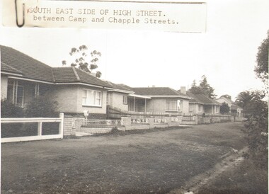
Photograph - HIGH STREET, KANGAROO FLAT, c1961
... /Markings: Written on reverse of photo 'Sth East side of High St... on reverse of photo 'Sth East side of High St. Same block ...Black and white photo: Part of residential street, three brick homes (probably cream) and one timber cottage at the far end, large nature strip. Three brick homes of similar style. Physical description: Loose black & white photo. Inscriptions/Markings: Written on reverse of photo 'Sth East side of High St. Same block as Methodist Church between Camp St & Chapple St. Kangaroo Flat.The Herald & Weekly Times Ltd. Melbourne Australiabuildings, residential, brick house, copyright not for unautherised repoduction -
 Ballarat Tramway Museum
Document - Photocopy, City of Ballaarat, Plan of Gardens, 1920s?
... drawings, many roads on the east side of Lake Wendouree not built... drawings, many roads on the east side of Lake Wendouree not built ...Photocopy - No Number, no date, other than BTM Number 228, No title – plan showing roads and trees in the Gardens area, early drawings, many roads on the east side of Lake Wendouree not built . Photocopy onto heat sensitive paper – 9 separate sheets joined with tape. An additional sheet added at the St. Aidans end showing roads – in pencil. Probably compiled for the BTPS by Bill Kingsley for planning purposes.Has “228” in biro on rear of sheet, and “Scale 100 foot to 1 inch” on front of sheet.trams, tramways, signals, forest city signals, equipment, electrical engineering -
 Whitehorse Historical Society Inc.
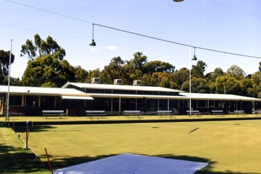
Photograph, Blackburn Bowling Club, 2012
... that a new site was needed. A site on the east side of Pakenham... that a new site was needed. A site on the east side of Pakenham ...First games played 1926. The Club was then situated in South Parade. Ladies were invited to join in 1927. The yearly fee was 1.10 sterling. In 1933 the green was officially opened by Robert Menzies. The clubhouse was finally completed in the late 1940's. By the 1960's membership had risen to the extent that a new site was needed. A site on the east side of Pakenham Street, south of the creek, was proposed but it was subject to flooding. In 1966, after the flooding of the creek was managed, the South Parade property was acquired and the new greens were ready by September 1966.Coloured photograph of the Blackburn Bowling Club, Pakenham Street Blackburn. Photograph shows rinks in front of the club house - 2012blackburn bowling club, sporting clubs, pakenham street, blackburn -
 City of Ballarat Libraries
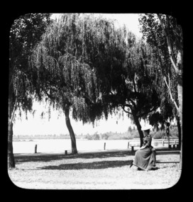
Glass Slide, A lady at Lake Wendouree
... Lake Wendouree from the western or Gardens side, looking.... Lake Wendouree from the western or Gardens side, looking east ...A view of Lake Wendouree taken from further back on the western foreshore. The lady's costume suggests these images were taken circa early 1890s.Previously unknown image of Ballarat. The set and its subjects indicate these images were produced to promote Ballarat and were perhaps aimed at tourists.Lake Wendouree from the western or Gardens side, looking east. -
 Ballarat Tramway Museum
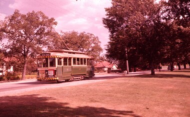
Slide - 35mm slide/s, Wal Jack, 23/01/1961 12:00:00 AM
... Photo of No. 17 in Wendouree Parade (east side of Lake...' in purple ink stamp. Photo of No. 17 in Wendouree Parade (east side ...Photo of No. 17 in Wendouree Parade (east side of Lake) showing 'View Point'. Looking across lake foreshore, at rear of tram. Tram not yet fitted with dash canopy lights, but small white stripe has been painted as has the tiger stripes on the bumper and the roof of the tram. Has ads for 'The Age' and 'Bourne Liquid Plastics'. Car number positioned under headlight. Slide going red, Taken on 23-1-61.'SEC Ballarat, No. 17 Wendouree Parade, View Point Line, 23-1-61' in blue ink and 'W.Jack' in purple ink stamp.tramways, trams, view point, wendouree parade, dash canopy lights, tram 17 -
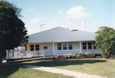 Lakes Entrance Historical Society
Photograph - Historic House, Holding M, 1996c
... centre front and right, east, side, and double windows left, west...East Gippsland Shire Council used this building as offices ...East Gippsland Shire Council used this building as offices 1996c.Coloured photograph of a weatherboard house situated at 545 Esplanade. It shows a neat house, roof extended over the veranda on front and both sides. Three internal chimneys, triple windows centre front and right, east, side, and double windows left, west, side across front of house. Veranda partly fenced. Neat flower garden, and ramp across the front of veranda. Gravel footpath through lawn. Lakes Entrance Victoriaarchitecture, houses, local history -
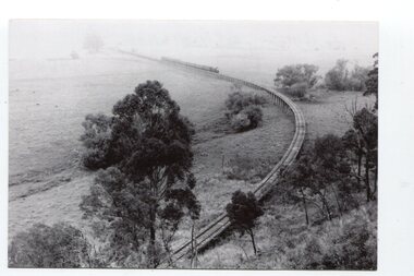 Orbost & District Historical Society
black and white photographs, Jude, Ray, 1915 - 1969
... River despite the town of Orbost being on the east side... River despite the town of Orbost being on the east side ...These photographs relate to the East Gippsland Railway. The Bairnsdale-Orbost railway was opened in 1916 to serve the agricultural and timber industry. Because of the decline in traffic and heavy operating costs, the line was finally closed in August, 1987. Orbost Railway Station was opened on Monday 10 April 1916 as the terminus of the Orbost railway line, and closed in 1987. The station was located on the west side of the Snowy River despite the town of Orbost being on the east side of the river, in order to save on the costs of a bridge over the river, which at the time had highly variable levels. These photographs are associated with the history of the Orbost-Bairnsdale railway line and therefore reflects the role that the rail line played in the social and economic history of Orbost.Seven black / white photographs and one postcard print.3103.1 on back - " Orbost- Snowy River flats viaduct 22-2-1964 ARHS special train Ray Jude photo" 3103.2 - on back -" Orbost Snowy River flats viaduct A.R.H.S. special train 22.2.1969" 3103.3 - on back - " A.R.H.S. special across bridge between Waygara & Nowa Nowa 22-2-1964 3103.4 - on back - " Nowa Nowa Boggy Creek Bridge A.R.H.s. Orbost tour Ray Jude photo" 3103.5 - on back - " Orbost 22-2-1969 SM office & goods shed Ray Jude photo" 3103.6 - on back - " Orbost Railway Yards - 22 February 19369 Ray Jude photo" 3103.7 - on back - " Orbost May 27 -1936 Orbost Rail Station" 3103.8 - on front - caption - Unloading Ballast Orbost line near Newmerella 1915 - J. Sullivan Colin ?orbost-railway east-gippsland-railway bairnsdale-orbost-railway -
 Warrnambool and District Historical Society Inc.
drinking glass: Eckers Hotel
... Hotel), once a well-known hotel in Warrnambool (on the east side... a well-known hotel in Warrnambool (on the east side of Liebig ...The glass comes from Eckers Hotel (Dooleys/Taylors/Eckers Hotel), once a well-known hotel in Warrnambool (on the east side of Liebig Street, between Lava and Koroit Streets). It was established by James Dooley in 1875 and closed in 1962. Joseph Ecker, who changed the name to 'Eckers' in 1913, was the licensee from 1910 to 1932. The name 'Eckers' was retained until the hotel closed. Eckers Hotel had a fine reputation as a comfortable and well-managed hotel and many sporting meetings were held there. The hotel building was demolished and the site today is occupied by an estate agency.This item has social significance significance as a glass with an inscription of a Warrnambool hotel (Eckers) and retained by a patron (Harry Heathcote, a local Warrnambool man) when the hotel closed. A drinking vessel made of clear glass. It is cracked from top to bottomWarrnambool, 'Eckers Hotel' Map of Australia with 'A.H.A' inscribed inside and the number '7' underneatheckers hotel warrnambool, joseph eckers, warrnambool -
 Orbost & District Historical Society
stamp holder and numbers, Victorian Government Railways, c. 1930s- 1980s
... River despite the town of Orbost being on the east side... River despite the town of Orbost being on the east side ...Used on the Orbost-Bairnsdale railway line which closed in 1987. The Bairnsdale-Orbost railway was opened in 1916 to serve the agricultural and timber industry. Because of the decline in traffic and heavy operating costs, the line was finally closed in August, 1987. Orbost Railway Station was opened on Monday 10 April 1916 as the terminus of the Orbost railway line, and closed in 1987. The station was located on the west side of the Snowy River despite the town of Orbost being on the east side of the river, in order to save on the costs of a bridge over the river, which at the time had highly variable levels This item is associated with the history of the Orbost-Bairnsdale railway line and therefore reflects the role that the rail line played in the social and economic history of Orbost.A stamp holder made of aluminium into which numbers and possibly letters can be inserted. Also a square shallow wooden box containing numbers which are used with the stamp. The numbers appear to be made of rubber.possibly V G R railway-history orbost-bairnsdale-railway -
 Orbost & District Historical Society
Victorian Railways pencil, Victorian Railways, c. 1960s-1980s
... of the Snowy River despite the town of Orbost being on the east side... of the Snowy River despite the town of Orbost being on the east side ...Used by Victorian Railways at stations on the Orbost-Bairnsdale line. The Bairnsdale-Orbost railway was opened in 1916 to serve the agricultural and timber industry. Because of the decline in traffic and heavy operating costs, the line was finally closed in August, 1987. Orbost Railway Station was opened on Monday 10 April 1916 as the terminus of the Orbost railway line, and closed in 1987. The station was located on the west side of the Snowy River despite the town of Orbost being on the east side of the river, in order to save on the costs of a bridge over the river, which at the time had highly variable levels. This item is associated with the history of the Orbost-Bairnsdale railway line and therefore reflects the role that the rail line played in the social and economic history of Orbost.A thick, hexagonal shaped pencil made of wood, painted dark blue, containing blue graphite marker.VICTORIA RAILWAYS written in gold lettering Emperor, Made in Australia railway-history victorian-railways orbost-bairnsdale-railway -
 Orbost & District Historical Society
stamp, C 1960's
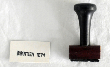
... River despite the town of Orbost being on the east side... River despite the town of Orbost being on the east side ...This stamp was used at the Orbost Railway Station. The Bairnsdale-Orbost railway was opened in 1916 to serve the agricultural and timber industry. Because of the decline in traffic and heavy operating costs, the line was finally closed in August, 1987. Orbost Railway Station was opened on Monday 10 April 1916 as the terminus of the Orbost railway line, and closed in 1987. The station was located on the west side of the Snowy River despite the town of Orbost being on the east side of the river, in order to save on the costs of a bridge over the river, which at the time had highly variable levels This item is associated with the history of the Orbost-Bairnsdale railway line and therefore reflects the role that the rail line played in the social and economic history of Orbost.A stamp with a black plastic handle. The bottom is wood and the stamp rubber. It has "BRUTHEN 1879" on it."BRUTHEN 1879"orbost-railway-station -
 Orbost & District Historical Society
stamp, 1970's
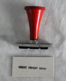
... the town of Orbost being on the east side of the river, in order... the town of Orbost being on the east side of the river, in order ...This stamp was used at the Orbost Railway Station. The Bairnsdale-Orbost railway was opened in 1916 to serve the agricultural and timber industry. Because of the decline in traffic and heavy operating costs, the line was finally closed in August, 1987. Orbost Railway Station was opened on Monday 10 April 1916 as the terminus of the Orbost railway line, and closed in 1987. The station was located on the west side of the Snowy River despite the town of Orbost being on the east side of the river, in order to save on the costs of a bridge over the river, which at the time had highly variable levels, This item is associated with the history of the Orbost-Bairnsdale railway line and therefore reflects the role that the rail line played in the social and economic history of Orbost.A stamp with a red plastic handle and a white stamping face - "ORBOST FREIGHT DEPOT".VUESTAMP AUSTRALIAorbost-railway -
 Sunbury Family History and Heritage Society Inc.
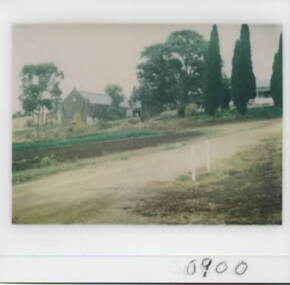
Photograph, Goonawarra Winery, c1970s
... at Goonawarra Vineyard, which is situated on the east side of Jacksons... at Goonawarra Vineyard, which is situated on the east side of Jacksons ...The property in the photograph is the winery building at Goonawarra Vineyard, which is situated on the east side of Jacksons Creek and on the north side of Macedon in Sunbury. The winery and homestead were established in 1858 by James Goodall Francis, who received a crown grant of land in Sunbury. From 1865 to the 1920s, the vineyard produced white wine grapes. James Goodall Francis died ion 1884 and the property was brought by M.P.Synott who ran merino sheep on the property. It wasn't until the early 1980s that Goonawarra reverted to be a vineyard after the property had been in the hands of a variety of owners. Goonawarra was one of Sunbury's earliest wineries to be established in the area.A coloured polaroid photograph with a white border, of a pathway leading to a double storey buildinggoonawarra winery, james goodall francis, wineries, jacksons creek -
 Melbourne Tram Museum
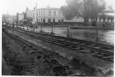
Photograph - Cable tram track removal Abbotsford St, 1935
... . with the building on the east side which have all since undergone two... but looking along the line of yokes. with the building on the east ...Photograph of track reconstruction of conversion of the cable to electric tramway in Abbotsford near the corner with Canning St, about August 1935. .1 - has the old cable track excavated before the yokes were cut of and the new track - rails and sleepers laid on the previous road bed. In the background is the Homebush Hotel. In the background is a shop advertising Robur Tea. .2 - similar photo but looking along the line of yokes. with the building on the east side which have all since undergone two demolitions. The former hotel building remains but has been converted to set of apartments.Yields information about the removal of cable tram track in Abbotsford St North Melbourne.Set of two Black & White Photographs. Two copies of each held.Has the TMSV Sales stamp on the rear.trams, tramways, cable trams, abbotsford st, conversion -
 Ringwood and District Historical Society
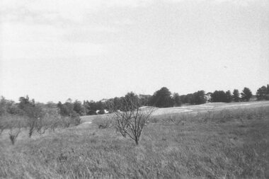
Photograph, Looking across remains of Frazer's orchard to state school, 1972
... . State School 4120 was enclosed on its north & east sides.... State School 4120 was enclosed on its north & east sides ...Updated Information from Bruce Frazer: This is Frazer's (not "Fraser") orchard, sold to A.V. Jennings Co. For housing development c1970. Address was "Alkoomi", Oban Rd. North Ringwood. State School 4120 was enclosed on its north & east sides by the orchard. Owned by Harold & Sylvia Frazer, 12 acres, growing mainly cherries plus plums & lemons. Photo was taken from neighbouring apple orchard (Williams) & shows street construction in the middle distance.Written on back of photograph, "Looking across remains of Fraser's orchard to state school, 1972". -
 Ringwood and District Historical Society
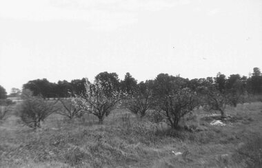
Photograph, Remains of Frazer's orchard, North Ringwood. State school on left - 1972
... . State School 4120 was enclosed on its north & east sides... was enclosed on its north & east sides by the orchard. Owned by Harold ...Updated Information from Bruce Frazer: This is Frazer's (not "Fraser") orchard, sold to A.V. Jennings Co. For housing development c1970. Address was "Alkoomi", Oban Rd. North Ringwood. State School 4120 was enclosed on its north & east sides by the orchard. Owned by Harold & Sylvia Frazer, 12 acres, growing mainly cherries plus plums & lemons. Photo was taken from neighbouring apple orchard (Williams) & shows street construction in the middle distance.Written on back of photograph, "Remains of [Fraser's] orchard. State school on left". -
 Ballarat Tramway Museum
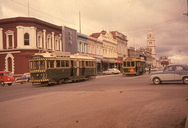
Slide - 35mm slide/s, Wal Jack, 13/07/1962 12:00:00 AM
... , and a roof ad. Has buildings of the east side of Lydiard St... of the east side of Lydiard St. in background looking towards Post ...Ballarat trams 43 and 27 in Lydiard St. North, at Mair St. 13-7-1962. Tram 43 heading south has Electric Cooking roof ad, 27 heading north, with briquettes ad on front of tram, and a roof ad. Has buildings of the east side of Lydiard St. in background looking towards Post Office. Quite a number of motor cars in photo. Both trams have dash canopy lights, but small white strip.'SEC Ballarat, Nos. 43 & 27 in Lydiard St. North 13-7-62' on one side and 'W.Jack Photo' on reverse, all in blue inktramways, trams, ballarat, lydiard st. nth, mair st, tram 43, tram 27 -
 Alfred Hospital Nurses League - Nursing Archive
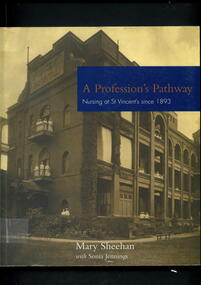
Book - Illustrated book, Mary Sheehan, A Profession's Pathway: nursing at St Vincent's since 1893, 2005
... photograph of the 1905 building c.1914, it shows the east side....1914, it shows the east side of the building with nurses ...This a comprehensive history of nursing at Melbourne's St Vincent's Hospital. It documents the transformation of nursing practice and education since the hospital's opening in 1893.Illustrated book. On front cover is a black and white photograph of the 1905 building c.1914, it shows the east side of the building with nurses on the balconies. Title in gold and white print on a blue rectangular background superimposed on this photo, as are the authors names in white print. On the spine in white print on a brown background are the abbreviated title, author's surname and publisher's name. On the back cover is a coloured photo of a group of nurses outside hospital entrance c.2004 on brown background.non-fictionThis a comprehensive history of nursing at Melbourne's St Vincent's Hospital. It documents the transformation of nursing practice and education since the hospital's opening in 1893.st vincent's hospital melbourne, nurses, nursing, hospitals-victoria-history -
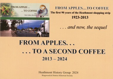 Ringwood and District Historical Society
Book - Heathmont Shopping Strip, From Apples to a Second Coffee 2013-2024
... trainline up to 165 Canterbury Road Area 3 - East side even numbers... trainline up to 165 Canterbury Road Area 3 - East side even numbers ...Soft covered wire bound book. Sequel to earlier book titled The First 90 years of Heathmont Shopping Centre 1923-2013.Contents: Area 1 - West side odd numbers - 95 Canterbury Road down to trainline Area 2 - West side odd numbers - from trainline up to 165 Canterbury Road Area 3 - East side even numbers - from Allens Road down to laneway Area 4 - East side even numbers - from laneway down to trainline What cannot be purchased in Heathmont in 2024 Strip Series: annual changes 2014 to 2024 Covid pandemic 2019-2020 Future directions Current HHG and Heathmont publications list. Acknowledgements: Heathmont History Group members - Laurie Allen, David Gee, Gerry Robinson, Ray Stevens, Trevor Weir. Sketches by David Williams (dec.). Ringwood & District Historical Society. -
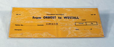 Orbost & District Historical Society
railways envelope, Victorian Railways, c. 1970s-1980s
... on the east side of the river, in order to save on the costs... the town of Orbost being on the east side of the river, in order ...Used at Orbost railway station for the consignment of goods/freight, in this case, timber to Westall. The Bairnsdale-Orbost railway was opened in 1916 to serve the agricultural and timber industry. Because of the decline in traffic and heavy operating costs, the line was finally closed in August, 1987. Orbost Railway Station was opened on Monday 10 April 1916 as the terminus of the Orbost railway line, and closed in 1987. The station was located on the west side of the Snowy River despite the town of Orbost being on the east side of the river, in order to save on the costs of a bridge over the river, which at the time had highly variable levels. This item is associated with the history of the Orbost-Bairnsdale railway line and therefore reflects the role that the rail line played in the social and economic history of Orbost.An unused brown/buff coloured goods/freight consignment envelope used by Victorian Railways, this one for timber from Orbost to Westall. 2498-78 VICTORIAN RAILWAYS From ORBOST to WESTALL Contents TIMBER railway-history orbost-bairnsdale-railway -
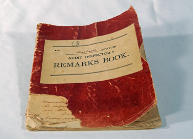 Orbost & District Historical Society
Victorian Railways remarks book, Victorian Railways, c. 1940s
... on the east side of the river, in order to save on the costs... on the east side of the river, in order to save on the costs ...Used at Orbost Railway Station, possibly by the Station Master, between 1944 and 1984. The Bairnsdale-Orbost railway was opened in 1916 to serve the agricultural and timber industry. Because of the decline in traffic and heavy operating costs, the line was finally closed in August, 1987. Orbost Railway Station was opened on Monday 10 April 1916 as the terminus of the Orbost railway line, and closed in 1987. The station was located on the west side of the Snowy River despite the town of Orbost being on the east side of the river, in order to save on the costs of a bridge over the river, which at the time had highly variable levels. This item is associated with the history of the Orbost-Bairnsdale railway line and therefore reflects the role that the rail line played in the social and economic history of Orbost.Book with a red cover. On the front cover VICTORIAN RAILWAYS Audit Inspectors Remarks Book, Orbost. Inside are numbered and lined pages with hand written information dating from 28/3/1944-13/8/1984, dated and signed by various station masters. Cover has a section missing from the bottom left.VICTORIAN RAILWAYS Audit Inspectors Remarks Book, Orbost.railway-history orbost-bairnsdale-railway -
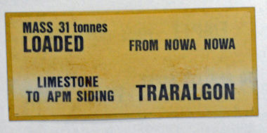 Orbost & District Historical Society
label / sign, 1970's -1980's
... the town of Orbost being on the east side of the river, in order... the town of Orbost being on the east side of the river, in order ...This item was used by Victorian Railways in 1980's. It was inserted onto the side of railway freight wagons. The Bairnsdale-Orbost railway was opened in 1916 to serve the agricultural and timber industry. Because of the decline in traffic and heavy operating costs, the line was finally closed in August, 1987. Orbost Railway Station was opened on Monday 10 April 1916 as the terminus of the Orbost railway line, and closed in 1987. The station was located on the west side of the Snowy River despite the town of Orbost being on the east side of the river, in order to save on the costs of a bridge over the river, which at the time had highly variable levels This item is associated with the history of the Orbost-Bairnsdale railway line and therefore reflects the role that the rail line played in the social and economic history of Orbost.A double -sided rectangular shaped label / sign, heavily laminated.Black print on light brown background. On one side : "MASS 31 tonnes LOADED; FROM NOWA NOWA; LIMESTONE TO APM SIDING; TRARALGON". On reverse : "EMPTY FROM TRARALGON; TO APM LIMESTONE SIDING ; NOWA NOWA".freight orbost-bairnsdale-railway -
 Lake Bolac & District Historical Society
Colour photograph, Lake Bolac township. 1963
... , the large building on the south-east side of the Ballarat road.... Starting centre left, the large building on the south-east side ...Crossroads at Lake Bolac, 1963. Junction of the Ballarat/Hamilton and Ararat/Mortlake roads. Starting centre left, the large building on the south-east side of the Ballarat road is Goodall's garage. Next door is the original Bush Nursing centre, then Dalgety's, the Bakery, the Milkbar and on the corner is the Bank of New South Wales building, Elder's, Green's drapery shop and the Lake Bolac Memorial Hall. On the traffic island in front of the Hall is the War Memorial and across the Woorndoo road is the Hotel (with the maroon roof) with stables behind. Across the road again is the Stanbury's General Store with their large warehouse behind.lake bolac, 1963, goodall, bush nursing, dalgety, elders, green, bank of new south wales, stanbury. -
 Ballarat Tramway Museum
Photograph - Black & White Photograph/s, 1900's?
... arrangements. On the east side of the site are rails, water wagon... arrangements. On the east side of the site are rails, water wagon ...Black and white photograph of the Ballarat Tramway Company Wendouree, depot with three horse trams standing outside the doors. Shows the arrangements for two access roads, doors and yard arrangements. On the east side of the site are rails, water wagon, portable shed and other materials. Photograph is a copy photograph, has drawing pin marks in the centre and on the edges and other damage. Trams have "Havelock Tobacco" roof advertisements. Colour photocopy, laminated, of this photograph on display 6/2000 at 02-02-06trams, tramways, depot, wendouree parade, horse trams, havelock -
 Orbost & District Historical Society
black and white photograph, C1916
... of the Snowy River despite the town of Orbost being on the east side... of the Snowy River despite the town of Orbost being on the east side ...This is a photograph of a railway camp, set up to house workers and their families when building the Bairnsdale to Orbost Railway in 1916. The Bairnsdale-Orbost railway was opened in 1916 to serve the agricultural and timber industry. Because of the decline in traffic and heavy operating costs, the line was finally closed in August, 1987. Orbost Railway Station was opened on Monday 10 April 1916 as the terminus of the Orbost railway line, and closed in 1987. The station was located on the west side of the Snowy River despite the town of Orbost being on the east side of the river, in order to save on the costs of a bridge over the river, which at the time had highly variable levels.This item is associated with the history of the Orbost-Bairnsdale railway line and therefore reflects the role that the rail line played in the social and economic history of Orbost.A black / white photograph of a campsite kitchen. The kitchen is outside against a roughly constructed hut. There are three women preparing food. Two men are drinking from tin mugs. a small child is crawling on the ground and another is seated.on back - "Railway Camp"orbost-railway newmerella-railway-camp transport -
 Ballarat Tramway Museum
Photograph - Black & White Photograph/s, Keith Kings, Feb. 1952
... has destination of East on side indicator and Chilwell.... Tram has destination of East on side indicator and Chilwell ...Yields information about Geelong trams in the late 1940's on the Chilwell - East - West lines.Black and White photograph of Geelong No. 8 as altered for one man operation. Photo taken at the East terminus. Tram has destination of East on side indicator and Chilwell on the front. Photo by Keith Kings 2/51.On the rear in ink. " Geelong No. 8 as altered for one man operation. East terminus 2/51". Keith Kings stamp and number E(7)(3) in top right hand corner.trams, tramways, geelong, east, chilwell, tram 8 -
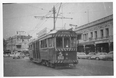 Ballarat Tramway Museum
Photograph - Black & White Photograph/s, Ian Barkla, c1960
... strip under the driver's cab windows. Has buildings on the east... strip under the driver's cab windows. Has buildings on the east ...Black and white photograph of Bendigo, northbound about to arrive at the Fountain. Photo taken after tram has passed the photographer. Tram has destination of "Nth Bendigo" Undated, tram has been fitted with dash canopy lights but not the enlarged white strip under the driver's cab windows. Has buildings on the east side of Pall Mall in background with many cars of the era - early 60's. Tram has "White Horse" whisky ad on rear drivers dash panel and two SEC roof ads.On rear in black biro "Bendigo No. 4 at the Fountain / (was last Geelong tram 25-3-56) / Ex Geelong 33, Ex 120 MMTB"trams, tramways, bendigo, pall mall, tram 4