Showing 330 items
matching lagoon
-
 Port Melbourne Historical & Preservation Society
Photograph - Sandridge Lagoon, Latrobe Library, 1920s
Photograph is a copy of one held in the PP Port Melbourne photo collection. It was donated and presented to the PMH&P Society by Joan WINTER of the City of Port Phillip at the August 1996 Annual General Meeting photograph of Sandridge Lagoon, viewed towards Bay: Western Jetty shown with several fishing vessels alongside. People on the Jetty (some with pushbikes); edge of Harper's building at right. (Laser copy also at A.06.04.B1 - 475.02) sandridge lagoon, industry - fishing, sport - yachting -
Glenelg Shire Council Cultural Collection
Photograph - Photograph - montage on card, Portland, n.d
Four black and white photos attached to grey cardboard a) Bentinck St. looking south, from post office b) 'Burswood' from a distance c) Causeway across Fawthrop Lagoon d) Portland lifeboat in gardens (no shelter)Front: 'Bentinck St, looking from post office' - black ink, handwritten, right of a) '(Burswood) Henty's Old Home' - black ink, handwritten, left of b) '(Causeway)' - black ink, handwritten, left of c) '(Lifeboat) Portland now in gardens' - black ink, handwritten, left of d)portland, streetscape, town -
Port Melbourne Historical & Preservation Society
Book, Pat Grainger, "They Can Carry Me Out", Jan 1992
In 1990 City Librarian Wendy MORRIS commissioned Pat GRAINGER to co-ordinate a State and Council funded oral history project, the final product of which was a book printed in time for the 1992 Port Melbourne Festival. Having been sold out for two years, it was reprinted with funds from the City of Port Phillip Cultural Development fund just in time to be launched at the 2002 Festival launch held at Beacon Cove on a Yarra Tram, 22 March 2002.2002 reprint of "They Can Carry Me Out" - Memories of Port Melbourne Blue, perfect-bound paperback book with white title and black line conversion of photo of fishing boats in the Lagoon. 96 pp, reprinted March 2002fishermans bend, education - primary schools, piers and wharves - station pier, piers and wharves - waterside workers, education - kindergartens, celebrations fetes and exhibitions, transport - aviation and aerodrome, transport - ferries, transport - shipping, garden city, mission to seafarers, transport - railways, transport - horse, built environment - civic, built environment - domestic, built environment - commercial, built environment - industrial, town planning - proposals shelved - bayside, religion, arts and entertainment, livestock, sandridge lagoon, migrants, built environment - public housing, centenary bridge, local government - city of port melbourne, royal visits and occasions, police, sport - australian rules football, societies clubs unions and other organisations, natural environment, business and traders, war - world war ii, deaths and funerals, flood, domestic life, gasworks, health - general health, excelsior hall, public action campaigns, ada mary a'beckett kindergarten, wendy morris, pat grainger, g borer & co, johnny allsorts pawnbroker, mckenzies milkbar, galatos chocolates, j e earl pty ltd, faram brothers hardware, jack porritt, liardet family, porritts boot shop, vintage port worth preserving project, phyllis anderson, norman barry, david beazley, leonard george 'dugga' beazley, florence beazley, george beazley, brenda bedford, lettie bradley nee walsh, margaret bride nee polson, anne callaghan, beris campbell, tony cannatelli, john carroll, john cass, margaret couch nee smith, brian couldrey, delva crawford nee rees, 'buffie' rees, joan curtis, elvir dragovic, james edward earl, linda edman, jessie edwards, lisa edwards, trevor emmett, judy faram, doug faram, george faram, richard faram, thomas faram, allen faram, a g warren, james murdock, margaret mclean, minnie mclean, m b muir, susie fox, william gleeson, sylvia gleeson, arnold goetz, lilian 'lil' goss nee johnson, gladys gott nee mccabe, stan gravias, george henry (harry) gray, len greaney, charles hall, bertha harvey nee carey, r graham carey, mac hatfield, f patricia (pat) hawkins, tippo hayes, tom hills, bradley hinge, lloyd holmes, norah howard nee mallet, voula hronakis, lorna johnson, diane keating nee bradley, alison kelly, june kirby, bob knell, tommy lahiff, nicole lalande, bill lane, kathleen lane nee moore, j s lang, ron laing, beverley lewis, andy libbis, peter libbis, emily lock, may lowe nee irving, wendy lowenstein, micael lucas, ted mccarthy, laura mcgill nee irving, vin mcnamara, elsie median nee mccabe, maree menzel, marie mills, marlene mitchell nee sharp, david moloney, ari pipilikas, ada polson nee bellion, les profitt, ted rohan, elizabeth saunders, vanessa savvaidis, prudence sheil, chutathip silpiphat, voula skourakis, flo stark, ted tobin, thelma todd, barbara villani, erica wilson, harry bocquet, nott street state school, port melbourne library, port melbourne temperance hall, swallow & ariell ltd, business and traders - hotels -
Port Melbourne Historical & Preservation Society
Photograph - Aerial view of (finally) in-filled Lagoon, Port Melbourne, 1931
Image seems to be one of several aerial shots around 1931, possibly all shot from one flight. Aerial photo of Port Melbourne c1931 showing clearly the finally filled Lagoon, and central area from Gasworks to past Bay Street, from Town Hall to Town Pier. Cable tram cars can be seen on Bay Streetsandridge lagoon, built environment -
Port Melbourne Historical & Preservation Society
Photograph - Starch factory', 1994
Donor had this print made for display purposes, from a neg belonging to the PMCC Engineering staff; one of a series shot by a staff member from vantage points relating to 19th C photos belonging to the city (in this case, beside the Lagoon)Colour photo of 'starch factory' (former Harper's factory) from corner West Esplanade and Beach Street late 1980s/early 1990s- building as shell only, waiting redevelopmentbuilt environment - industrial -
Port Melbourne Historical & Preservation Society
Photograph - President, Glen Cosham, displays gift from City of Port Phillip Curator, Joan Winter, PMHPS AGM, Gina Kowalski, Aug 1996
One of ten standard colour photos taken during 1996 Annual General Meeting of the PMH&PS - President Glen Cosham shows framed photo of the lagoon and western jetty presented to the Society by Joan Winter, curator of the City of Port Phillip collectionsocieties clubs unions and other organisations, liana thompson, mayors, don taggart, noel turnbull, jenny turnbull, ingeborg mccullough, denys mccullough, anne callaghan -
 University of Melbourne, Burnley Campus Archives
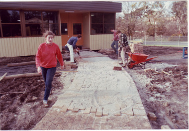
Photograph - Colour print, James (Jim) Pleasance, Students Building Brick Paths Around Relocatable Buildings, 1985
Note in paper catalogue, "Hard surfacing the pathways around the new relocatable buildings erected on the site of the old Lagoon fill (completed 1977). Students completed most of the work with the central garden area designed by Californian exchange staff member Steve Mullany, 1985." 2 similar colour photographs. Students building brick paths around relocatable buildings in the Quad. On reverse, "13.Sep.1985," and, "Hard surfacing with brick.hard surfacing, bricks, pathways, students, gardens, californian exchange, staff, steve mullany, quad, relocatable buildings, students working outside -
Port Melbourne Historical & Preservation Society
Photograph - Various sporting ovals and events, Port Melbourne, Ron Laing, 1990s
Part of Ron Laing's collection of photographs recording Port Melbourne over a thirteen year period. Donated to the PMH&PS by the photographer.A set of 24 colour photographs taken by Ron Laing, covering the Port Melbourne Football Oval at North Port, the various ovals in the Murphy Reserve complex, Lagoon Reserve, Dog Obedience School at Murphy's, and a Big Bay Swim in progress Port to Williamstown 2000sport - recreational grounds, sport - swimming, ron laing, lagoon reserve -
Glenelg Shire Council Cultural Collection
Artwork, other - Bowl - created as a gift from Ernest York of Mildura to Elsie Rose, Ernest York, 1950s
Small wooden, footed bowl with inlaid 'E'. Made by Ernest York of Mildura from wood from a Portland gun carriage rescued from the edge of Fawthrop Lagoon in the 1950's. The white of the 'E' is bone and the shadow is ebony from Africa. made as a gift for Elsie Rose -
Bendigo Historical Society Inc.
Map - JANIEMBER WEST : COUNTY OF BENDIGO, September 1955
Map. Janiember West, County of Bendigo, Powlett, Janiember East, Jarklan, Kinypanial, River Loddon, Kelsh's Lagoon. By authority W.M. Houston, Government Printer. Drawn and reproduced at the Department of Lands and Survey, Melbourne. Price 2/-.September 1955. (number 64 in map cupboard 1)W.M. Houston, Government Printermap, bendigo, janiember west -
Port Melbourne Historical & Preservation Society
Newspaper - Newspaper re South Melbourne and Port Melbourne, 1856
Copy of South Melbourne newspaper(?) cut off on right hand side. Items recorded include : Ferrars St: Sandridge Rd: York St: Crossing places at the lagoon: sub inspector of nuisances: slaughtering: candle manufactory: Sandridge Road toll: Mechanics Institute: Holy Trinityindustry - manufacturing, local government, kitchen, cr ross, cr service, cr gardiner, cr palk, mrs powell, joshua kenworthy, frederick goss, samuel dodds, south melbourne -
Port Melbourne Historical & Preservation Society
Photograph - Aerial view of Port Melbourne, circa 1928
Aerial photo of Port Melbourne c1928 focusing on the Gas Works area spanning Port Melbourne and Albert Park. Shows the finally filled Lagoon, and area from the Harpers Starch factory to Foote St, Albert Park and from the bay to just over Richardson/Liardet Stssandridge lagoon, built environment - industrial, industry, gasworks, joshua brothers distillery, harpers starch factory -
Bendigo Historical Society Inc.
Map - JANIEMBER WEST : COUNTY OF BENDIGO, September 1955
Map. Janiember West, County of Bendigo. Loddon River, Janiember East, Powlett, Kinypanial, Jarklan. Welsh's Lagoon. By authority W.M. Houston, Government Printer, Melbourne. Drawn and reproduced at the Department of Lands and Survey, Melbourne, September 1955, Price 5/-. (number 66 in map cupboard 1)W.M. Houston, Government Printer, Melbourne.map, bendigo, janiember west -
Port Melbourne Historical & Preservation Society
Document - CD-ROM, Albert DAVIES scrapbook, AMS imaging, 1927 - 1932
Original scrapbook was given to Mr Bill PHILLIPS by Mr DAVIES' daughter after the death of her parents. Janet BOLITHO arranged for scanning and CD to be produced, with no restrictions on use.CD containing scans of 135 pages of a scrapbook compiled by Albert (Bert) DAVIES from approximately 1927- 1932. Main topics covered are Port Melbourne Council elections; housing development on Fisherman's Bend; the lagoon infill; Depresion relief; industrial and union issues; and the campaign for an airport on Fisherman's Bendlocal government, fishermans bend, politics, sandridge lagoon, state government victoria, albert (bert) davies, bill phillips, local government - city of port melbourne, depression, societies clubs unions and other organisations, transport - aviation and aerodrome -
Port Melbourne Historical & Preservation Society
Document - Property valuation working papers, Lagoon Confectioners, Graham Street, Port Melbourne, George Levey, 1950 - 1974
Sample of working papers relating to the valuation of 29 premises in Port Melbourne. These papers were maintained by Mr George LEVEY, who was the City Valuer for PMCC from around the mid 1950s to about 1974. Details are all in manilla folders. .12 - Lagoon Confectioners . 191-193 Graham Streetbuilt environment - commercial, business and traders, local government - city of port melbourne, industry, george levey, lagoon confectionery pty ltd -
 Bendigo Historical Society Inc.
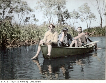
Photograph - BPS TOUR TO KERANG DECEMBER 1964, December 1964
Hand coloured photograph on cream mount of group on small rowing boar on lagoon. Female figure in bow. Older male with hat in centre. Younger male and child near back of boat. Trees and bulrushes in background. Inscriptions: on front - 'BPS Tour to Kerang 1964'. On back - 'Jenny Nicholas', 'Frank Kennedy'Frank Kennedy?person, group, rural -
 Phillip Island and District Historical Society Inc.
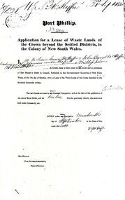
Document, Grant to W.J.McHaffie for lease of Crown land
J D McHaffie, Phillip Island's first leaseholder, relate how McHaffie set up his headquarters (and later built his house) alongside what is now known as McHaffies lagoon. The McHaffie brothers – John David and William – occupied Phillip Island under a license from the Admiralty in 1842 and farmed it as a sheep run.Historical3 A4 photocopies showing application for lease in 1850, size and description of the land and instructions for the application.w.j.mchaffie, land grant, farming, saltwater creek, crown land -
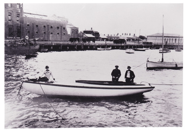
 Port Melbourne Historical & Preservation Society
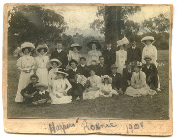
Photograph - Robert Harper & Co picnic, 1908
Robert Harper & Co had an industrial complex on Beach Rd from Sandridge lagoon to Post Office Place. A wide variety of goods were produced including rice, starch, spices, cocoa, flour, spices, oatmeal, jelly crystals. Most of the complex was demolished around 1980 but some buildings have been transofmed into apartment blocks.Digital copy of Black and White photo mounted on card with the words "Harpers Picnic 1908" written below. The group of twenty two (22) includes two young children and the whole group are dressed in their finery and one man in the centre appears to be playing the piano accordion. The location of the bushland setting is unknown.social activities, industry - food, industry - manufacturing, robert harper & co ltd -
Port Melbourne Historical & Preservation Society
Photograph - Photocopy, Aerial view, Swallow & Ariell to infilled Lagoon, 1946
Donor was researching property on the corner of Stokes and Graham St, as old timers claim it was "the Nelson Hotel" although there is no record of such in licensing records. Particular building is at upper left of this image.Large photocopy of an aerial photo. 1946 view from Swallow & Ariell to the infilled lagoon and HMAS Barracks. Poor quality image but shows St Joseph's Catholic Church; Holy Trinity; Edwards Park; Lady Forster Kindergarten; Methodist Church on Graham St (no longer there), Bay St. ; three storey Derham houses built environment - industrial, industry - food, swallow & ariell ltd, religion - anglican (holy trinity), religion - wesleyan methodist church, religion - roman catholic church (st josephs), nelson hotel, frederick thomas derham, built environment - domestic, business and traders - hotels -
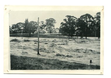 Orbost & District Historical Society
black / white photograph, January 1934
Damage estimated at £500,000 was caused by the 1934 floods in the Orbost district. This 1934 flood was devastating, destroying a section of the 1922 Orbost bridge, wrecking fences, bridges and roads, dumping silt and debris on the rich river flats and drowning cattle. This photograph shows Lochiel Lagoon ( the billabong) in the foreground. Ten minutes after this photograph was taken, the centre span of the Orbost Bridge was washed away.This item is a pictorial record of the 1934 floods, a significant part of Orbost's history.A black / white photograph of swirling floodwaters with township in the background.orbost-floods-1934 natural-disasters-floods -
 Bendigo Historical Society Inc.
Document - STATE RIVERS AND WATER SUPPLY COMMISSION : KIMBOLTON RECREATIONAL AREA SEWERAGE PLAN
State Rivers and Water Supply Commission. Eppalock Project. Plan document titled: Kimbolton Recreational Area Committee. Sewerage of 'C' Section club sites. Rising Mains. Number 101378A is in bottom right corner. Diagrams: Detail pipe inlet at Lagoons, Detail pipe outlet. Plan scale: 1 inch = 6 chns. state infrastructure, water supply, coliban system, eppalock -
 Port Melbourne Historical & Preservation Society
Photograph - Lagoon, Port Melbourne, 1970s
Copy of B&W photograph c1920 taken from the Eastern Jetty looking across Lagoon to Esplanade West. Yacht 'Hero' in foreground, pumphouse at right, flour mill at left. Nets drying along Western Jetty. The ketch 'Ripple' off left belonged to the Stennikens. Known as a 'ti-tree' ketch, it was used to transport ti-tree and shell grit from down the bay.On rear: 'D Beazley photo collection Neg Nos PM004/19 and 20'sandridge lagoon, industry - fishing, sport - yachting, hero, ripple, robert harper & co ltd, piers and wharves - miscellaneous -
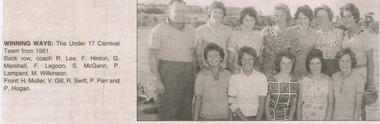 Bendigo Historical Society Inc.
Newspaper - JENNY FOLEY COLLECTION: WINNING WAYS
Bendigo Advertiser "The way we were" from Thursday, October 7, 2004. Winning ways: the under 17 Carnival team from 1961. Back row: coach R. Lee, F. Hinton, G. Marshall, F. Lagoon, S. McGann, P. Lampard, M. Wilkinson. Front: H. Muller, V. Gill, R. Swift, P. Parr and P. Hogan.newspaper, bendigo advertiser, the way we were -
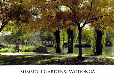 Wodonga & District Historical Society Inc
Photograph - Eric Sumsion Gardens
Mr Eric Sumsion was the gardening curator for Wodonga Shire in 1956. He had previously operated a bootmaker’s shop in High Street, Wodonga for many years. Eric saw the potential of the area in Wodonga now known as Belvoir Park and asked permission to work on part of the area. He eventually purchased a house adjoining the area giving him more time and easy access to work on it. The Lagoon, Lake Huon, Belvoir Lagoon, Belvoir Park and Sumsion Gardens are all names used over time for what is today one of Wodonga’s favourite recreation and picnic spots. In the 1800s river boats could enter Lake Huon from Wodonga Creek. There was a jetty south of where the water fountain is today. In later years, this jetty was used by the Clay Bird Shooting Club. From the early 1900s football and cricket were played there, and some mining leases were also allowed. At one time there were open gravel pits between House Creek and the main lagoon, and these were subsequently filled with town garbage collected by the Council. In the late 1940s, Wodonga Golf Club took over part of Belvoir Park for a 9-hole golf course with sand greens. The Golf Club House was built in 1946. The Club extended the course to 12-holes when the football ground moved to Martin Park and the course later extended to 18 holes. Under Eric Sumsion’s care the area became a magnificent area of parkland and curated gardens. After he had retired in 1961 his work was acknowledged by the Shire Engineer, Mr Bill Page, when the Sumsion Gardens were named in his honour. He was also responsible for the design and curating of many other gardens in Wodonga, including those at Sarah Coventry and Richardson Park. Eric Sumsion died in July 1988, aged 85.This item is significant because it acknowledges the dedication and commitment of Eric Sumsion to the Wodonga Community.A collection of photographic images and an advertisement related to the work of Eric Sumsion in Wodonga.eric sumsion, parks and gardens wodonga -
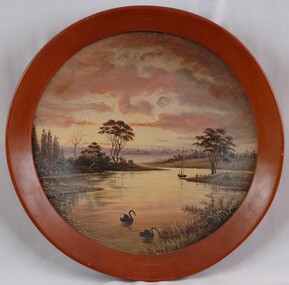 Glenelg Shire Council Cultural Collection
Painting, Sunset, Blairs Creek 1893, 1893
Roundel painting in circular frame. Scene depicts a lagoon edged with grass and low bushes in foreground and trees in background. Two black swans swim in foreground and a boat with a mast and rigging is anchored near land and a tree at centre right of image. Top half of painting is a sunset with clouds in pink, red, white, yellow, indigo, russet. These colours are generally reflected in foreground water. Framed in round wooden frame.Front: (no inscriptions) Back: "Sunset" Blair's Creek, Portland. Jan. 7th 1893 (centre) (black ink). 90 (ink on varnish) (centre left). 1996 (pencil) (upper left). -
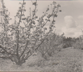 University of Melbourne, Burnley Campus Archives
Album - Black and white print, A.W. Jessep, Lantern Slide Photograph Album, 1930-1931
Black and white photographs pasted in light cardboard loose-leaf photograph album, "1930" written on inside front cover. Probably prints of A.W. Jessep's Lantern Slides. (1) Orchard. (2) Lawn and glimpse of Principal's Residence. (3) Shrub. (4) Shrub. (5) As (2). (6) Garden view. (7) Garden view. (8) Orchard. (9) Lagoon or Boulevard Paddock see B11.0351.a.w. jessep, orchards, lawns, principal's residence, shrubs, garden views, orchards, lagoon paddock, boulevard paddock, lantern slides -
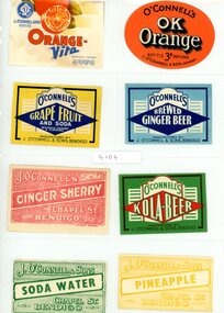 Bendigo Historical Society Inc.
Document - VARIOUS DRINKS AND FOOD LABELS
Twenty eight drinks and food labels: J.O'Connell and Sons. Bendigo Prize Lemonade. J.O'Connell and Sons Bendigo Lime Flavor and Soda. D. Oswald Eaglehawk Hop Ale. XXXX Stout bottled by Glover and Son Chapel St. Bendigo. C.J. Glover Chapel St. Bendigo Ginger Punch. J.O'Connell Orange Vita - Ok Orange - Grapefruit and Soda - Brewed Ginger Beer - Ginger Sherry - Kola Beer - Soda Water - Pineapple. Dan Oswald tomato sauce. Glover and Son Tomato Soup. Qt Orange fruit Drops. Cottee's Sparkling Passiona. Lagoon Confection Long Toms. Bartlett Pears. The Bendigo Preserving Co. Golden Bar Orlean Plum Jam. Bendigo Preserving Co. Apricot Jam. Bendigo Preserving Co. Plum and Raspberry Jam. Golden Holme Apples. Rosella. Cottee's sparkling Drinks. Chocolate Cream Toffees. Lagoon Spearmint.business, retail -
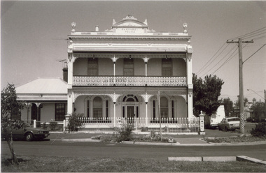 Port Melbourne Historical & Preservation Society
Photograph - Guernsey House, Esplanade East, Port Melbourne, Arthur Rowan, 1986
As a member of the Port Melbourne Historical and Preservation Society, donor Arthur ROWAN photographed a series of significant buildings in the Port and South Melbourne area over several years. A selection of nineteen of these was presented to the Port Melbourne Society in 1993. Guernsey House, 232 Esplanade East. Private home established in 1883 [Eastern shore of Lagoon] First owner: Peter GRUT and his wife Mary, parents of Henry Brouard GRUT, Peter Gallienne GRUT and John Bichard GRUT. Peter G and John B both became architects.Small print mounted on white card, with mounted, typed caption: Guernsey House, 232 Esplanade Eastbuilt environment - domestic, sandridge lagoon, arthur rowan, peter grut, guernsey house, mary grut, peter gallienne grut, henry brouard grut, john bichard grut -
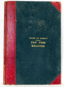 Orbost & District Historical Society
ledger, 1906
This ledger was used by the Shire of Orbost from 1906 to 1910. The item was donated to Orbost & District Historical society from P.R.O.V. as a Place of Deposit (POD) item for safe keeping by a local history group or museum. The shire covered an area of 9,347 square kilometres and existed from 1892 until 1994 when it became part of the East Gippsland Shire Council. Orbost was at first included in the Bairnsdale Shire from 1882 and was later part of the Tambo Shire. Because of travelling distances the Croajingalong Shire was created in 1892 (name changed to Orbost Shire 17.2.1893 with James Cameron as the first Shire President. In 1994 it amalgamated to become part of East Gippsland Shire Council. In Australian suburbs and rural towns where the sewer wasn't connected, people usually had an outside toilet. The toilet seat was made of a plank of wood secured at its ends to the walls of the building with a large round hole in the middle. Underneath was the removable sanitary pan and on a regular basis, usually weekly, the full pan was taken away and replaced with an empty one. This was the job of the sanitary carter. the sanitary depot was in Martins Lane, Orbost Development of the Orbost Wastewater Treatment Facility began in the 1960’s with the construction of four treatment lagoons. Shortly after the construction of the lagoons the sewerage system was installed throughout Orbost.This item is a record of accounting for the local government. The collection of sanitary pans was a necessary service before the Orbost township was had its own wastewater treatment facility.A large register of pan fees for the Shire of Orbost. A black hard cover book with red binding and marbled end pages. Entries are hand-written in black ink.On spine - "PAN FEES REGISTER: in gold lettering. In centre of front cover in gold - "SHIRE OF ORBOST (underlined) PAN FEES REGISTER"orbost-shire-council ledger-pan-fees sewage orbost-township-sanitary-service -
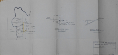
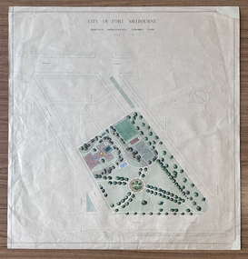 Port Melbourne Historical & Preservation Society
Plan - Edwards Park improvements (Trugo Green), Port Melbourne, 1940s - 1950s
Although undated, this plan is probably from the late 1940s or early 1950s. Around this time Port Melbourne Council were looking to built a basketball court in Lagoon reserve, and shelters and a senior citizen's clubhouse in Edwards Park. PMHPS does to believe the basketball court shown in the plan was built but the Port Melbourne Senior Citizens and Trugo Club is at the location shown on the plan. A shelter is in a similar location to the one on the plan. A children's playground existed in that location shown in a photograph from the 1930s. The round flowerbed where the paths cross in the centre of the park in not in the 1930s photograph but is a current feature of Edwards Park.Plan drawing to scale, hand coloured, of proposed improvements to Edwards Park (Trugo Green), undated possibly late 1940s or early 1950s."City of Port Melbourne"built environment - recreational facilities, parks and gardens, sport - trugo, port melbourne trugo club, edwards park