Showing 1252 items matching "land sale"
-
 Ringwood and District Historical Society
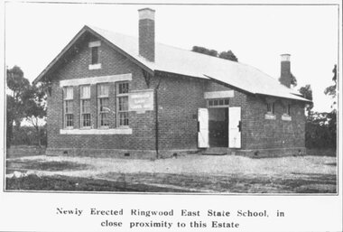
Photograph, Newly Erected Ringwood East State School, Everard Road, 1925 (Two Photographs)
... on back of photograph, "Photo taken from Sub. Div. plan Land Sale.... Div. plan Land Sale 1st November 1924. Ringwood East Electric ...Printed below photograph, "Newly Erected Ringwood East State School, in close proximity to this Estate". Written on back of photograph, "Photo taken from Sub. Div. plan Land Sale 1st November 1924. Ringwood East Electric Station Estate, 1st November 1924. School Everard Road". Typed below another copy: "Ringwood East S.S. On completion 1925". -
 Ringwood and District Historical Society
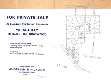
Document - Folder, Reaghill Estate Subdivision, Ringwood, Victoria - circa 1958
... Bifold land sale brochure glued to brown stationery folder... land sale brochure glued to brown stationery folder ...Bifold land sale brochure glued to brown stationery folder with advertisement including map of original subdivision (circa 1958) and subsequent 1982 re-subdivision of Lot 7 Vista Avenue - LP41463 - Part of Crown Allotment 43, Parish of Ringwood, and 4-page brochure for sale of 4 luxury new homes built by Bovis Homes Aust. P/L as presented by Lyndsay Edmonds Homes. Subdivision includes Bedford Road, Homebush Court, Vista Avenue and Vista Court. Original protective covenant: "One dwelling house only on each of Lots 1-15 for a period of 15 years". Agent - Anderson & Hickling, 239 Collins Street, Melbourne. (Phone) Cent.25. -
 Lakes Entrance Historical Society
Book, Morrissey, D.W and Morrissey E.W, Lakes Entrance a Short History revised Edition, 1980
... , timber industry, early settlers and survey and sale of land..., timber industry, early settlers and survey and sale of land..., timber industry, early settlers and survey and sale of land ...History of Koorie inhabitants through to fishing industry, timber industry, early settlers and survey and sale of land. The opening of the entrance to allow shipping industry to operate bringing much trade and movement of primary produce etc. Local schoolHistory of Koorie inhabitants through to fishing industry, timber industry, early settlers and survey and sale of land. The opening of the entrance to allow shipping industry to operate bringing much trade and movement of primary produce etc. Local schoolMargaret Campbell''land settlement, religion, aboriginals -
 Bacchus Marsh & District Historical Society
Map, Subdivision of the Manor House Property Bacchus Marsh c.1908
... . The land put up for sale was from the estate of the late Mr and Mrs... of maps. The map shows portions of land for sale from.... The land put up for sale was from the estate of the late Mr and Mrs ...This land sales plan shows allotments of land offered for sale in the inner township area of Bacchus Marsh in 1908. The land put up for sale was from the estate of the late Mr and Mrs J.E. Crook. That being James Elijah Crook and his wife Harriet, (nee Athorn). The Crooks had been resident in Bacchus Marsh since the 1840s and were prominent members of the community. They were prominent in the business, social and civic affairs of the town and district. In the 1850s the Crooks acquired the Manor House and nearby land once owned by the Bacchus family. James Crook died in 1889. When Harriet Crook died in February 1908 their estate was offered for sale. This included the large stone home known as the Manor House and various parcels of land including around 50 allotments of land near the Manor House, bounded by Young, Lerderderg, Crook and Main Streets. Most of these allotments of land were sold in October 1908. The Manor House itself was passed in at the sale and continued to be owned by the Crook family for several decades after 1908.A single page map on a single page of a bound volume of maps. The map shows portions of land for sale from the subdivision of the Manor House property in Bacchus Marsh in 1908. The names of most of the buyers of the portions of land have been hand-written into the various allotments they purchased. The maps are pasted into a bound volume containing 76 maps or plans in total. High resolution digital image stored on BMDHS computer network. bacchus marsh victoria maps, land sales bacchus marsh, manor house bacchus marsh, crook family bacchus marsh -
 Kew Historical Society Inc
Legal record - The Indenture, Crown Portion 86, otherwise known as 'The Morgan Deed', 1852 (and later)
... Framed 1952 Indenture recording the sale of land in Kew... the sale of land in Kew to pioneering Kew families. Legal record ...This indenture once formed part of the City of Kew's Municipal Collection. Cr. W.D. Vaughan in his history 'Kew's Civic Century' (1960) records on page 194 that: "The original deed of conveyance of the land being all of Crown Portion 86, Kew, purchased by John Quick, James Venn Morgan, Samuel Derrick and William Derrick was presented by the Historical Society of Victoria on behalf of Mrs Fryer, a daughter of the later J.V. Morgan, to the [Kew] Council on August 5, 1941. Crown Portion 86, comprised all the land between Cotham Road and High Street to an alignment opposite the east boundary of Glenferrie Road. On it the first residential house was built by Mr. J.V. Morgan in 1852." Following the donation, the Indenture was surrounded by other original related text and explanatory notes and framed. The resulting framed documents are the largest framed objects in the collection.The Indenture and the accompanying contextual documents are some of the most historically significant manuscripts to have survived since the settlement of Kew in the 1850s. They provide a link to Kew's most famous pioneering families.Framed 1952 Indenture recording the sale of land in Kew to pioneering Kew families.james venn morgan, john quick, william derrick, samuel derrick, kew (vic) - history, kew (vic) - pioneers, samuel watts, kew (vic.) — municipal collection -
Kew Historical Society Inc
Plan - Willsmere Park Estate, Kew, 1926
... Park Estate, Kew. The 1926 land sale advertised '40 superb... of the Willsmere Park Estate, Kew. The 1926 land sale advertised '40 superb ...Subdivision plans and real estate flyers/brochures reveal a number of aspects of urban development and history. The Kew Historical Society's collection of these plans, as well as advertisements extracted from magazines, cover key aspects of community development and architectural history of Kew and Kew Eat as well as surrounding suburbs. While most of the plans in the collection were gifted to the Society by the former City of Kew, a number of other plans and advertisements have been donated by individuals, of which this is an example.Original 4-page, bifold subdivision plan of the Willsmere Park Estate, Kew. The 1926 land sale advertised '40 superb villa allotments' on the 'Yarra Heights'. Streets within the subdivision included: Willow Grove, Kilby Road, Elm Grove and Belford Road. The double page spread on pages 2 and 3 shows the detailed plan of the 40 lots, surrounded by public parkland [Willsmere Park] and the Kew Golf Links. By the time that this version of the plan was released, only the lots on Willow Grove and Kilby Road remained. willsmere park estate -- kew (vic.), subdivisions - kew (vic.), subdivisions -- kew east (vic.), willsmere park -- kew east (vic.) -
 Ringwood and District Historical Society
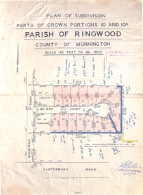
Map - Plan of Subdivision, Parts of Crown Portions 10 and 10B Parish of Ringwood - 1958
... on scrap paper backing from Land Sale Brochure with description... on scrap paper backing from Land Sale Brochure with description ...Folded subdivision map of 15 residential allotments in McKay Court Ringwood, off Wantirna Road north of Canterbury Road. Rubber stamped by Surveyors and Chartered Engineers J.S. Watson & Associates, Mornington and South Yarra, with illegible signature dated 17/2/58. Handwritten notations indicating allotment sale names and amounts or where passed in. Accompanying clipping on scrap paper backing from Land Sale Brochure with description of available services and local facilities and terms of sale - £75 Deposit £10 Monthly. -
 Melbourne Tram Museum
Document, Melbourne & Metropolitan Tramways Board (MMTB), "MMTB Road traffic Regulations 1958", Jan. 1958
... and safety zones. Has a McLean and Son advertisement for a land sale... and safety zones. Has a McLean and Son advertisement for a land sale ...Document produced by the MMTB for the information of Traffic Officers and Employees in Jan. 1958 - contains a reprint of the Victorian Road Traffic Regulations detailings the road rules. Extracted from the Jan. 1958 issue of Royal Auto Journal by the RACV. Section 13 details the regulations for passing stationary trams and safety zones. Has a McLean and Son advertisement for a land sale in Indented Head, Geelong region.Demonstrates a method the MMTB used to inform its staff of the road traffic regulations.Document - brown card covers side stapled with an extract from RACV Royal Auto Jan. 1958 pages 21 to 30.regulations, racv, mmtb, information, safety zones, traffic control -
 Whitehorse Historical Society Inc.
Document, Market Shop Sites subdivision, 20/11/1929 12:00:00 AM
... 5 pages describing sale of land in Whitehorse Road, Market... describing sale of land in Whitehorse Road, 5 pages describing sale ...5 pages describing sale of land in Whitehorse Road,5 pages describing sale of land in Whitehorse Road, Market Street, Box Hill5 pages describing sale of land in Whitehorse Road,land subdivision, market street, box hill, coghill & haughton, t.r.b. morton & son, ellingworth, john roger -
 Bacchus Marsh & District Historical Society
Map, Bacchus Marsh Tuesday 23rd Oct. 1888, Lodge & Dunn's Paddocks 1888. Business and Mansion Sites
... A single page paper map showing allotments of land for sale... showing allotments of land for sale along the Parwan Road ...This map was created as a plan for an auction of land close to the Bacchus Marsh Railway Station. The auction took place on 23 October 1888. 102 allotments of land from an area known as Lodge and Dunn's paddocks was offered for sale. The auction was conducted by auctioneers based in Melbourne and was advertised in Melbourne newspapers as well as in the Bacchus Marsh Express newspaper. The auction plan contains a range of details including the selling agents, Munro and Baillieu; W.P. Lockhart; and John Turner, all of Melbourne, deposit terms for purchases, price of railway passes for a return trip from Melbourne to Bacchus Marsh of 1 shilling, and a description of the land as having 'magnificent views and perfect drainage'. A single page paper map showing allotments of land for sale along the Parwan Road in Maddingley. The map is pasted into a bound volume containing 76 maps or plans in total. High resolution digital image stored on BMDHS computer network. At bottom on left side: 'Harston & Co. Lith, Melb.'land sales bacchus marsh, land sales maddingley, bacchus marsh victoria maps, maddingley victoria maps -
 Bacchus Marsh & District Historical Society
Map, Bacchus Marsh Suburban Allotments Parwan Road Lodge & Dunn's Paddocks 1888
... A single page paper map showing allotments of land for sale... and Dunn's paddocks was offered for sale. Land Sales Bacchus Marsh ...This map was created as a plan for an auction of land close to the Bacchus Marsh Railway Station. The auction took place on 23 October 1888. 102 allotments of land from an area known as Lodge and Dunn's paddocks was offered for sale. A single page paper map showing allotments of land for sale along the Parwan Road in Maddingley. The map is pasted into a bound volume containing 76 maps or plans in total. High resolution digital image stored on BMDHS computer network. land sales bacchus marsh, land sales maddingley, bacchus marsh victoria maps, maddingley victoria maps -
Glen Eira Historical Society
Document - Hengar, Glen Eira Road, 356, Elsternwick
... the land sale history since 1851 and gives a brief history... the land sale history since 1851 and gives a brief history ...A copy of two page typed report by Hilary Bullock and Rosalind Landells, dated 18/01/1990, on the history of Hengar, a dower house built for the Langdon family in 1887/1888. The report includes an explanation of the term dower house, outlines the land sale history since 1851 and gives a brief history of the occupancy of Hengar from 1888 to 1989. The file also includes one page of undated, unattributed handwritten working notes.landells rosalind, bullock hilary, hengar, glen eira road, elsternwick, holloway j m, langdon henry j, rosecraddock, beemery park estate, lirrewa, caulfield town hall, langdon family, deanmead a, griffith alfred, langdon e e, langdon h j, langdon laura, langdon henry, langdon bessie, sadler emily amy, brenton v c, herz s, beth riukan girls’ college, happy days kindergarten, florence herald herbert, happy days child minding, manners and customs, preschools -
 Bacchus Marsh & District Historical Society
Map, Gaynor Street Area Land Sales, Maddingley, 1888
... This map was produced for a major sale of land...A single page paper map showing land allotments for sale...This map was produced for a major sale of land ...This map was produced for a major sale of land in the Maddingley area of Bacchus Marsh in 1888. The sale was conducted by two firms from Melbourne, Carney and Kelly 12 Swanston Street Melbourne. and 'Richardson, Kerr & Co. 40 Flinders Lane Melbourne. 136 blocks were for sale.A single page paper map showing land allotments for sale in the Maddingley area of Bacchus Marsh. Locations shown include Gaynor Street, Maddingley Road South, Parwan Road, Mitchem Street, Typpynge Street, Finn Street and East Maddingley Road. . The map is pasted into a bound volume containing 76 maps or plans in total. High resolution digital image stored on BMDHS computer network. bacchus marsh victoria maps, maddingley victoria maps, land use, maddingley victoria history, land sales bacchus marsh, land sales maddingley -
Whitehorse Historical Society Inc.
Document, Kaufmans Road, 1896
... Documents and contracts about the sale of land bounded..., 1896. Documents and contracts about the sale of land bounded ...Documents and contracts about the sale of land bounded by Kaufmans, Canterbury and Bakers Roads Blackburn, 1896.Documents and contracts about the sale of land bounded by Kaufmans, Canterbury and Bakers Roads Blackburn, 1896.Documents and contracts about the sale of land bounded by Kaufmans, Canterbury and Bakers Roads Blackburn, 1896.canterbury road blackburn, bakers road blackburn, schwab, henri samuel, morton, thomas richards burrowes, land sales, kaufmans road blackburn -
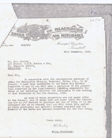 Whitehorse Historical Society Inc.
Legal record - Correspondence, Public Open Spaces, 24/12/1929 12:00:00 AM
... of Blackburn and Mitcham to Mr Geo. Morton requesting valuation of land.... Morton requesting valuation of land for sale for the Parks ...Letter from H.T. Bishop, Shire Secretary, Shire of Blackburn and Mitcham to Mr Geo. Morton requesting valuation of landLetter from H.T. Bishop, Shire Secretary, Shire of Blackburn and Mitcham to Mr Geo. Morton requesting valuation of land for sale for the Parks and Gardens Committee, dated 24 / 12 / 1929. Valuations provided by Geo. Martin dated 6/ 1 / 1930.Letter from H.T. Bishop, Shire Secretary, Shire of Blackburn and Mitcham to Mr Geo. Morton requesting valuation of land land values, shire of blackburn and mitcham, bishop, herbert thomas., morton, george, main street, blackburn, gardenia street, husband road, forest hill, surrey road, holland road, blackburn south, canterbury road, whitehorse road, nunawading, glendale street, williams road, south parade, tunstall -
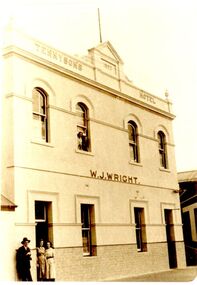 Port Fairy Historical Society Museum and Archives
Photograph
... in the Great Land Sale for 780.12.8 (Pounds, shillings and pence... the freehold in the Great Land Sale for 780.12.8 (Pounds, shillings ...Tennysons Hotel Sackville Street Port Fairy Patrick Tennyson leased the Farmers Inn in 1882 and applied to change the name to Tennysons Hotel. In 1885 he bought the freehold in the Great Land Sale for 780.12.8 (Pounds, shillings and pence) and then carried out extensive renovations. This double storied addition was added in 1893. The hotel continued under various licensees until it burned down in 1977 under the name "Fishermen's Arms". This photograph was taken during the licencee W J WrightBlack and white photograph of facade of two story building hotel, sackville street, port fairy, tennysons, fishermens arms, farmers inn, w.j.wright -
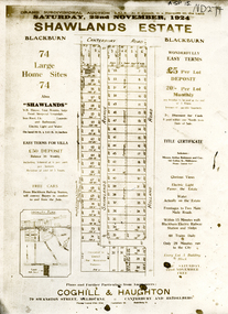 Whitehorse Historical Society Inc.
Document, Shawlands Estate, 22/11/1924 12:00:00 AM
... Notice of Sale of land Holland Road and Canterbury Road... Notice of Sale of land Holland Road and Canterbury Road Notice ...Notice of Sale of land Holland Road and Canterbury RoadNotice of Sale of land Holland Road and Canterbury Road Blackburn Original in Haughton Maps LaTrobe LibraryNotice of Sale of land Holland Road and Canterbury Road land subdivision, canterbury road, blackburn south, holland road, shawlands avenue, coghill & haughton, shawlands estate, haughton map collection, state library of victoria. latrobe library -
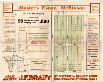 City of Moorabbin Historical Society (Operating the Box Cottage Museum)
Flyer - Master's Estate, McKinnon
... The end of WWI bought new interest in residential land... of WWI bought new interest in residential land. This sale must ...The end of WWI bought new interest in residential land. This sale must have been just before the electrification of the railway line from the city to Frankston which happened in 1922.Example of the progress of the Municipality of MoorabbinAdvertising flyer for auction of real estate sales - plan of building blocks for saleMaster's Estate, McKinnon - 99 Blocks - Agent: J. F. Bradymanchester road (now mckinnon road), tucker road, moylan street, lancaster street, preston street, real estate, bentleigh, mckinnon, moorabbin -
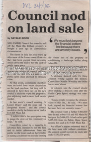
![Map, Plan of Subdivision of Crown Portion 23 & parts 24-25, Parish of Korkuperrimul [1900s?]](/media/collectors/5e461d8021ea67224c82f2a1/items/675fe058304668462205d4fb/item-media/675fe0ef304668462205d7d6/item-fit-380x285.jpg) Bacchus Marsh & District Historical Society
Bacchus Marsh & District Historical SocietyMap, Plan of Subdivision of Crown Portion 23 & parts 24-25, Parish of Korkuperrimul [1900s?]
... A single page paper map showing 20 blocks of land for sale... A single page paper map showing 20 blocks of land for sale ...The Parish of Korkuperrimul includes a significant section of the township of Bacchus Marsh and extends in western and northern directions from the township area. The date of the subdivision indicated on this plan has not been established. The engineer's stamp on the drawing shows the firm of Muntz and Muntz who were operating under that name in the early part of the 20th century.A single page paper map showing 20 blocks of land for sale in the Parish of Korkuperrimul. Scale 100 feet to 1 inch. The map is pasted into a bound volume containing 76 maps or plans in total. High resolution digital image stored on BMDHS computer network. Stamped: 'Muntz & Muntz Civil Engineers, Architects & Surveyors, Trustees Chambers ?? Cor Collins Street and Bank Placeland sales bacchus marsh, bacchus marsh victoria maps, land sales korkuperrimul parish -
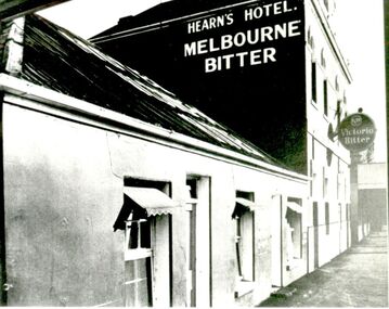 Port Fairy Historical Society Museum and Archives
Photograph
... in the Great Land Sale for 780 pounds.12 shillings and 8 pence... the freehold in the Great Land Sale for 780 pounds.12 shillings and 8 ...Tennysons Hotel Sackville Street Port Fairy Patrick Tennyson leased the Farmers Inn in 1882 and applied to change the name to Tennysons Hotel. In 1885 he bought the freehold in the Great Land Sale for 780 pounds.12 shillings and 8 pence and then carried out extensive renovations. The double storied addition was added in 1893. The hotel continued under various licensees until it burned down in 1977 under the name "Fishermen's Arms". This photograph was taken during the licencee W J Wright; the single story was the Farmers InnBlack and white photograph of facade of Hearn’s hotel with two advertising signs for beerhotel, sackville street, tennysons hotel, farmers inn, fishermen’s arms, inn, w.j.wright, patrick tennyson -
![Map, Millbank Estate Bacchus Marsh Thursday 4th October 1888 [Land sales], 1924](/media/collectors/5e461d8021ea67224c82f2a1/items/67765662eb6d2cbd24e0797f/item-media/67765682eb6d2cbd24e07a41/item-fit-380x285.jpg) Bacchus Marsh & District Historical Society
Bacchus Marsh & District Historical SocietyMap, Millbank Estate Bacchus Marsh Thursday 4th October 1888 [Land sales], 1924
... Single page map showing land allotments for sale at auction... sale map is a typical example of housing estate land sales ...The Millbank Estate was a parcel of land close to the centre of the shopping area of Bacchus Marsh which was sub-divided and offered for sale in 62? lots on the 4th October 1888. The lots had frontages to Ballarat Road (Main Street), Maddingley Road (now Grant Street), Turner Street, Millbank Street, Clarinda Road (now Clarinda Street), and an unnamed street south of Turner Street (possibly known as Grant Street at this time) which connected to Maddingley Road through the vicinity of the present day Bacchus Marsh Hospital. This was a significant sub-division of land and represented a major expansion of residential housing in Bacchus Marsh in the late 19th century. The map includes a wealth of detail about the time of the sale, where it will take place, who the selling agents were, the deposit terms for purchases and details of a special train from Melbourne to Bacchus Marsh on sale day. The location of the allotments in relation to the shopping and commercial area of Bacchus Marsh, Maddingley and the railway station are indicated on an inset map within the overall map and poster. The Millbank Estate area was an area which had once belonged to the Grant family who were prominent early citizens of Bacchus Marsh and lived in a house in this area known as 'Millbank'.This land sale map is a typical example of housing estate land sales advertising maps produced by real estate agents in this era. The map is significant for the detailed information it provides about when and where land was sold for new housing estates in Bacchus Marsh in the late nineteenth century.Single page map showing land allotments for sale at auction in Bacchus Marsh in October 1888. A significant portion of the map is missing from the bottom right side. land sales bacchus marsh, land subdivsion bacchus marsh, housing estates land sales bacchus marsh, grant family bacchus marsh, millbank estate land sales -
 Bacchus Marsh & District Historical Society
Map, Lerderderg Park Lands sale plan. 1911
... This plan was for the sale of parcels of land from.... The parcels of land for sale are coloured in red.The Lerderderg River...This plan was for the sale of parcels of land from ...This plan was for the sale of parcels of land from the Lerderderg Park Estate property in 1911. Advertising for the sale appeared in the Bacchus Marsh Express newspaper through July of 1911. The property was situated only a few kilometers from the township of Bacchus Marsh. The agents for the sale were L. A. Fairbairn & Co.Lerderderg Park Estate was a significant and early colonial property in the Bacchus Marsh area. This plan provides details about the first time the property was subdivided for sale. It is therefore documents an important moment in the history of this property and the broader trend of the subdivision of older and larger properties in the district.A single page paper plan showing allotments of land for sale from the Lerderderg Park property owned by John Wills. The parcels of land for sale are coloured in red.The Lerderderg River and Pyke's Creek Irigation Channel shown on the plan are in blue ink. The rest of the plan is a dark cream or beige colur with the text in black ink. The plan has been extensively annotated with hand-written notes indicating the names of people who purchased the various parcels of lands and the prices paid for those lands. Part of the top of the plan containing some text appears to be missing. The plan is pasted into a bound volume containing 76 maps or plans in total. Top: Have received instructions to Sell, account Mr John Wills, his renowned LERDERDERG PARK LANDS, so well and favourably known throughout the Commonwealth. In areas from 3 acres to 1276 acres. Every lot is either rich lucerne land (or portion now under lucerne) with some higher land adjoining Railway Station, and 2 Milk factories within 2 miles, absolutely the finest land in Victoria. Bottom: THIS IS THE FIRST SUBDIVISIONAL SALE of Rich Flats in Bacchus Marsh since the Pyke's Creek Scheme, and every lot is commanded by it. Only 32 miles from Melbourne.bacchus marsh victoria maps, land sales, lerderderg park estate, land subdivision -
Canterbury History Group
Pamphlet - Camberwell Golf Links, c1932 original
... Brochure produced for Land Sub-division sale by auction... Street Trams Vintage Cars Brochure produced for Land Sub-division ...Brochure produced for Land Sub-division sale by auction of Camberwell Golf Links on Saturday 28 May c1932. Reproduced from the original, includes Map and some historic photographscamberwell, fairmont avenue, camberwell road, christowell street, trams, vintage cars -
Tatura Irrigation & Wartime Camps Museum
Poster, Subdivision of Township Allotments
... Single sheet of paper, laminated. Advertising land..., laminated. Advertising land subdivision for sale in the township ...Poster depicting the land which was being sold by J S Darby on the 3 December 1890. Auctioneer was Martin Cussen and Co. Map shows location of land.Single sheet of paper, laminated. Advertising land subdivision for sale in the township of Rushworth. Being sold by Martin Cussen and Co, auctioneers for J S Darby. Shows map of land subdivision.rushworth, land subdivision, martin cussen and co, j s darby -
 Kew Historical Society Inc
Photograph - Victorian Villa, High Street, c.1922
... , bought by Edward Glyn in the land sale of 16th October 1851..., bought by Edward Glyn in the land sale of 16th October 1851 ...Subdivision plans are historically important documents used as evidence of the growth of suburbs in Australia. They frequently provide information about when the land was sold on which a built structure was subsequently constructed as well as evidence relating to surveyors and real estate and financial agents. The numerous subdivision plans in the Kew Historical Society's collection represent working documents, ranging from the initial sketches made in planning a subdivision to printed plans on which auctioneers or agents listed the prices for which individual lots were sold. In a number of cases, the reverse of a subdivision plan in the collection includes a photograph of a house that was also for sale by the agent. These photographs provide significant heritage information relating house design and decoration, fencing and household gardens.An old inscription on this photograph identifies it as ‘an elegant timber villa in High Street. It occupied part of Lot 91, bought by Edward Glyn in the land sale of 16th October 1851, and run as a flower farm’. The subdivision called the ‘Flower Farm Estate’ in East Kew occurred in 1922. [The subdivision plan is on the reverse of this photo.] The Estate included 61 lots on either side of Boorool Road between High Street and Harp Road. In the MMBW Detail Plan 2017 of 1926, a number of these new villas had already been built. Matching houses with MMBW maps can always be a challenge, however if this house was near the corner of Boorool Road and High Street, it seems to fit the profile of a house called ‘Maxton’ (demolished).Photographer's name on photograph, lower right, and stamp on mount lower right: "A. Aberline, Glenferrie".houses - maxton - high street - kew (vic.), violet farm estate, subdivisions - kew (vic.) -
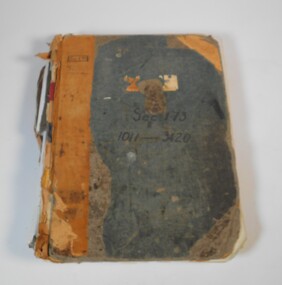 Bendigo Historical Society Inc.
Administrative record - Application for allotments for sale 1908-1974
... the applications for allotments of land for sale. The headings in the book... of land for sale. The headings in the book are: number ...Green cover book with brown leather spine. The book lists the applications for allotments of land for sale. The headings in the book are: number of application, date of registry, date of application, surname, Christian name and address, parish, allotment, section, area, local land board schedule, classification, crown grant, references and remarks. It covers the years 1908 -1974.Spine has a red label with gold letters. On the cover the remnants of a label, under in ink Sec.173, 1011-3420. At top left of the cover Sec.171 SHland sales, govrnment -
![Map, Plan of Town Allotments Bacchus Marsh [1873]](/media/collectors/5e461d8021ea67224c82f2a1/items/677a8ee7ab7bb47995c5573f/item-media/677a8fdeab7bb47995c55b56/item-fit-380x285.jpg) Bacchus Marsh & District Historical Society
Bacchus Marsh & District Historical SocietyMap, Plan of Town Allotments Bacchus Marsh [1873]
... later became known as 'Stone Villa'. The sale of his land...A single page paper map showing 30 blocks of land for sale... later became known as 'Stone Villa'. The sale of his land ...James Young was a prominent businessman, land owner and public figure in the early colonial period of Bacchus Marsh. After his death in 1871 land remaining from his estate in Bacchus Marsh was sold at auction in 1873. The sale of his estate included the substantial stone residence in Bennett Street which later became known as 'Stone Villa'. The sale of his land in 1873 was conducted by local auctioneer James Crook. 29 allotments were advertised for sale, although the plan for the sale indicated 30 allotments. The sale notice in the Bacchus Marsh Express of 11 October 1873 noted that the allotments were " in the very centre and heart of the most populous and business portion of the township, at the same time being the only remaining portion of the business block available for purchase by public sale, which fact intending purchasers should not lose sight of, as the opportunity cannot occur again". The designation of a new street, 'Bennett Street', shown on the plan, is also indicated in the advertising, "In reference to the main street frontages, opposite the Border Flour Mills. The Auctioneer would also direct attention to the plan, showing the formation of a new thorough fare (Bennett street) leading from Young street into Gell street, thus opening up the township on the high, more healthy, and commanding position so much to be desired for private dwellings".An important cartographic document which indicates an early major subdivision of land in the inner urban area of the Bacchus Marsh township. This subdivision lead to the continuing residential and commercial development of the township of Bacchus Marsh in the later part of the 19th century. The location of two well known demolished public structures, the Free Gardeners Hall in Gell Street, and the Old Mechanics Institute Hall (aka the Buffs Hall), on the corner of Young and Bennett Streets, are also shown on this map.A single page paper map showing 30 blocks of land for sale around 1873 in the vicinity of Bennett Street and Lerderderg Street. Described in contemorary sources as a 'lithographed copy'. No scale is indicated. The map is pasted into a bound volume containing 76 maps or plans in total. High resolution digital image stored on BMDHS computer network. land sales bacchus marsh, bacchus marsh victoria maps, james young 1816-1871, bacchus marsh roads and streets, bennett street bacchus marsh -
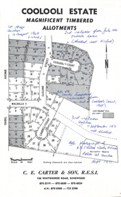 Ringwood and District Historical Society
Document - Folder, Coolooli Estate Subdivision, Ringwood East, Vic. - Four Releases 1969-1975
... Collection of Subdivision Plans, Land Sale flyers, Auction... of Subdivision Plans, Land Sale flyers, Auction notices, and Real Estate ...Collection of Subdivision Plans, Land Sale flyers, Auction notices, and Real Estate Agent's notes for Coolooli Estate, Ringwood East, Victoria. Subdivision includes Coolooli Court, Isabel Avenue, Walhalla Drive, Cleland Street, Landell Court, Byways Drive, Heathwood Street and Hume Street, released over four stages - First Stage auction 16 August 1969, Second Release private sales from July 1970, Third Release Auction 11 September 1971, Final Release auction June 21st 1975. Agents - C.E. Carter & Son, 126 Whitehorse Road, Ringwood until moving to 122 Whitehorse Road in 1973 - Tel. 870 6024, 870 6830, 870 2519, A.H. 723 3298, 870 6960. Digitised copy of photograph - A.B. Carter and Andy McLean at Coolooli Estate auction, 11 September, 1971. -
 Eltham District Historical Society Inc
Document - Property Binder, 813 Main Road, Eltham
... Newspaper article: Council nod on land sale, Diamond Valley... melbourne Newspaper article: Council nod on land sale, Diamond ...Newspaper article: Council nod on land sale, Diamond Valley Leader, 24 July 2002, Nillumbik Council voted to sell this land. Newspaper article: Grapple on Gateway, Diamond Valley Leader, 11 September 2002, photograph of demonstrators against development of land. Newspaper article: Prominent site protected, Diamond Valley Leader, 6 December 2006, Victorian Civil and Administrative Tribunal upheld decision to refuse development permit, action by Eltham Gateway Action Group. Newspaper article: Daniel's a tree fella, Diamond Valley Leader, 24 July 2002, Daniel Jarvis involved in Planet Ark's National Tree Planing Day, Friends of Falkiner Street Reserve.main road, eltham, property, eltham gateway action group, daniel jarvis, friends of falkiner street reserve. -
 Eltham District Historical Society Inc
Journal - Newsletter, Newsletter, No. 270 June 2023
... Land Sale Documents • Annual General Meeting - Saturday 15th... Land Sale Documents • Annual General Meeting - Saturday 15th ...Contents: • Recording Our History by Jim Connor • Our Next Meeting - 2.00pm Saturday 10th June 2023 • Heritage Walk - Saturday 1st July 2023 - Research Valley South Side • Eltham Horse and Pony Club by Tony Brocksopp • What’s Happening by Liz Pidgeon • Frank’s New Shoes by Jim Connor • Many Hands Make Flags Fly!! By Terry Beaton • A Catalogue of Killings by Richard Pinn • Early Land Sale Documents • Annual General Meeting - Saturday 15th April 2023 • Eltham Cemetery Stories by Liz Pidgeon o Anne Hunniford, (Burgoyne) nee Hamilton, 1813-1899, Pioneer o Anne Jane Hunniford 1855-1927, Post Mistress The Shire of Eltham Historical Society was formed in October 1967. The first newsletter of the Society was issued May 1978 and has been published continuously ever since on a bi-monthly basis. With the cessation of the Shire of Eltham in late 1994, the Society's name was revised to Eltham District Historical Society and this name first appeared with issue No. 103, July 1995. The collection of the Society's newsletters provides a valuable resource on the history of the Society's activities, office bearers and committee members, guest speakers and subjects of historical interest pertinent to the former Shire of Eltham and the Eltham District.A4 newsletter distributed to members (Digital and A4 photocopy)newsletter, eltham district historical society