Showing 1290 items
matching lands
-
 Clunes Museum
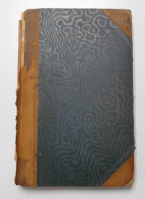
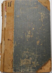
Book, DEPARTMENT OF LANDS AND SURVEY, LICENCE
RECEIPTS ISSUED TO CUSTOMER DENOTING LOCALITY TO SPLIT AND TAKE AWAY EUCALYPTUS TIMBER FROM BUSH. LICENCES ISSUED PER QUARTER.BLUE CARDBOARD COVERED BOOK CONTAINING TIMBER LICENSE FOR ORDINARY WOOD ISSUED SEPTEMBER 1884 TO OCTOBER 1892. RECEIPT NUMBERS 124121 - 124130ON FRONT COVER: TIMBER LICENSE ORDINARY WOOD 50/- NO.1 EXHAUSED AFTER AUDIT 23-8-92local history, book, licence, receipt, timber licence -
 Peterborough History Group
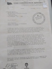
Document - Three letters pertaining to the retention of the Old Bridge
Upon confirmation that a new bridge was to be built, there was some discussion about the possibility of retaining the old bridge for pedestrian purposes, or part of the old bridge as a fishing platform. These letters are part of the correspondence re an organisation taking responsibility for the ongoing maintenance so the old bridge could be retained.The old bridge was constructed of locally sourced timber and was such an important structure to the town when built. Its sentimental value saw locals attempt (although unsuccessfully) to retain the old bridge.Two A4 Typewritten letters, one from the Road Construction Authority to the National Trust Australia, the other from the Department of Conservation Forests & Lands to Mr John Irvine. And one hand written letter.RCA letter is stamped "Received 22 Aug 1985", Dept of Conservation Forests & Lands has a pencilled phone no inscribed.peterborough, curdies river bridge, old peterborough bridge, department of conservation forest & lands, road construction authority -
 Bendigo Historical Society Inc.
Map - Marong County of Bendigo
Map of Marong. Drawn and reproduced at the Dept. of Lands and Survey, Melbourne. By authority: W.M. Houston Government Printer. June 1953.On the back in blue pen: certified plan parish Marong, signed minister and seal affixed for land S sec.72 evidence act. I certify that this a true plan parish Marong (signature illegible) minister for lands.map, marong -
 Glenelg Shire Council Cultural Collection
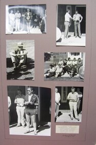
Photograph - Photograph - Montage. Handover Ceremony of Portland Section of Great South West Walk to Department Conservation Forrest and Land, 13/04/1986
Glenelg Shire Council RecordsPhotographic Montage of handing over of Portland section of Great South West Walk, to the Department Conservation, Forests and Lands.Front: Bottom Right: Sticker, typed Handing over to Depatment,Conservation, Forests and Lands following inaugurul walk on City of Portland Section of the Great South West Walk. (now a complete circuit) Signature in pen Grahame McDonald 13th April 1986. -
Port Melbourne Historical & Preservation Society
Plan, The Township of Sandridge, 30 Mar 1859
Plan of the township of Sandridge.Lithographed at the Public Lands Office, Melbourne, March 30th 1859engineering - roads streets lanes and footpaths, municipal district of sandridge -
Whitehorse Historical Society Inc.
Letter - Correspondence, Mullum Mullum Creek
Letter to the Minister of Land & Works from Richard R. Cross, George Hislop, Neil Faconer (sic) and Robert Leith .Letter to the Minister of Land & Works from Richard R. Cross, George Hislop, Neil Faconer (sic) and Robert Leith regarding a track through Crown Lands which has been applied for by Messrs. Logan and Galbraith. With map.Letter to the Minister of Land & Works from Richard R. Cross, George Hislop, Neil Faconer (sic) and Robert Leith .mullum mullum creek, roads and streets, cross, richard r., hislop, george, falconer, neil, leith, robert, warrandyte mitcham track, logan, galbraith -
 Bacchus Marsh & District Historical Society
Map, Village allotments, Parish of Myrniong, County of Bourke
Myrniong is a village 9 kilometers west of Bacchus Marsh. Prior to 1863 the area was known as Blow's Flat. This map which was produced in 1903 and according to the catalogue record of this map held at the State Library of Victoria was based on an earlier map created in 1861. The early layout of streets for the village of Myrniong can be seen on this map. The streets shown are, Main Street, Hardy Street, Blow Street, Myrniong Street, Shuter Street, and Blackwood Street. An area marked as a reserve for a school can be seen between Hardy Street and Main Street.A single page paper map. A cadastral parish map of Myrniong in Victoria, showing numbered land allotments. Photo-lithographed at the Department of Lands & Survey, Melbourne, in 1903. Based on an original map created in 1861. The map is pasted into a bound volume containing 76 maps or plans in total. High resolution digital image stored on BMDHS computer network. Surveyed by John Hardy, Surveyor ; photo-lithographed at the Department of Lands & Survey, Melbourne by T.F. McGauran, 24.12.03myrniong parish plan, myrniong parish maps -
Whitehorse Historical Society Inc.
Map, Nunawading. County of Bourke, 1878
Photocopy of map of Shire of Nunawading.Photocopy of map of Shire of Nunawading. Note: Fosters v President of the Shire of Nunawading. On Verso: Copied from the most up to date by the Dept of Lands, 1878. Laid before the Executive Council, 11 June 1878. Shows land holders.Photocopy of map of Shire of Nunawading.shire of nunawading, maps -
 Bendigo Historical Society Inc.
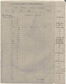
Document - RAILWAYS COLLECTION: CROWN LANDS SURVEYED IN DISTRICT OF SANDHURST
RAILWAYS COLLECTION -large cream -coloured paper photocopy of 'Crown Lands Surveyed in District of Sandhurst' x 2 Information has been entered into columns showing Parish, Town Lands, Suburban Lands, Country Lands, Total Lands Surveyed, Date of Survey, Date of Sale, most Dates of Sale are 1854 The documents have been cancelled.document -
Port Melbourne Historical & Preservation Society
Plan - Proposed land sub-division, west of railway, Sandridge, 19 Nov 1866
1866 plan of proposed sub-division of land at Sandridge, west of railway. Includes manure depot.J. Noone (Photolithographer, Dept. of Lands and Survey) J. Hardy (Assistant Surveyor)town planning, town planning - proposals shelved, j noone, j hardy -
Whitehorse Historical Society Inc.
Map, Parish of Nunawading, 1927
Map of the Parish together with part of the Borough of Box Hill.Map of the Parish together with part of the Borough of Box Hill. Includes names of lease or license holders, sizes of leases and in some areas dates of leases. Roads, railway and stations marked. Original survey by W.J.Busocon, 1915. Manuscript note: 15.2.1927 Verified Dept. Lands and Survey.Map of the Parish together with part of the Borough of Box Hill. maps, parish of nunawading, borough of box hill -
Whitehorse Historical Society Inc.
Map, M.M.B.W, c1962
Melbourne Metropolitan Area Base Map series sheet 235, covering part, Mitcham, Nunawading and Ringwood areas.Melbourne Metropolitan Area Base Map series sheet 235, covering part, Mitcham, Nunawading and Ringwood areas. Prepared by Department of Lands and Survey and Melbourne and Metropolitan Board of Works from State aerial Survey, June 1957 and Cadastral Survey information, August 1960. Scale 1:4,800.Melbourne Metropolitan Area Base Map series sheet 235, covering part, Mitcham, Nunawading and Ringwood areas. maps, mitcham, nunawading, ringwood, melbourne and metropolitan board of works, victoria. department of lands and survey -
 Bendigo Historical Society Inc.
Document - LANDS OFFICE: CANCELLED R.A.'S FROM COSTERFIELD, SEYMOUR, BENDIGO, 1930 - 1950
Document: collection of individually tied files. Right to occupy residence area miners' rights. 1930's - 1950's. Includes Seymour, Costerfield, Bendigo. Heathcote, Cohuna, Trafalgar.Lands Officeplace, bendigo, land sales, miners' rights, bendigo, sandhurst, land sales, residence areas, costerfield, seymour, bendigo -
 Bendigo Historical Society Inc.
Document - LANDS OFFICE: CANCELLED R.A.'S FROM CASTLEMAINE/BENDIGO/INGLEWOOD
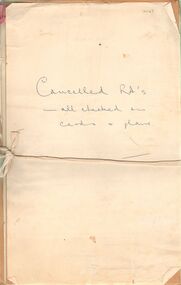
Document: collection of individually tied files, tied with faded red ribbon, tied across centre with white tape. Applications for right to occupy residence areas - miners rights. On front page ' cancelled R.A's - all checked on cards and plans' written in blue ink.Lands Officeplace, bendigo, castlemaine residence areas, bendigo, sandhurst, land sales, residence areas, miners rights -
 Bendigo Historical Society Inc.
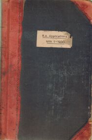
Document - LANDS OFFICE: R. A. APPLICATIONS NOS. 1 - 1930, 1936
Document: green hard cover journal with red spine and corners. On front cover ' R.A. Applications Nos. 1 - 1930' Residence areas - applicants for land Bendigo, Maldon, Castlemaine, Daylesford, Eaglehawk, Marong and district. 1936Lands Officeplace, bendigo, land sales, bendigo, sandhurst, land sales, r.a. applications -
 Bendigo Historical Society Inc.
Document - LANDS OFFICE: SANDHURST LAND SALES 1865 - 1869, 1865 - 1869
Document: green hard cover journal. Red spine and corners. Contains name index to areas in Sandhurst region, including rural areas. LH page: allots. secs., locality, page book. RH page: same information.Lands Officeplace, bendigo, land sales, bendigo, sandhurst, land sales, land surveyed -
 Bendigo Historical Society Inc.
Document - LANDS OFFICE, INWARDS/OURWARDS CORRESPONDENCE 30/3/1868 - 18/8/1868, 1868
Journal: green hard cover journal, with buff spine and corners. Contains details of inward/outward correspondence and action taken. Index in front contains names of letter writers, referenced by page number to details of letters received/sent.Lands Officeplace, bendigo, lands office, sandhurst, correspondence -
 Bendigo Historical Society Inc.
Document - LANDS OFFICE: SALE OF CROWN LANDS BY PUBLIC AUCTION, 25/5/1898 - 26/8/1915
Journal: green hard cover journal with brown spine and corners. LH page: lot, county, town or parish, section, allotment, extent, why not sold, upset price per acre, sold for per acre. RH page: value of improvements, name of purchaser, residence, deposit forfeited, total amount. Contains details of sales by public auction across Victoria.Lands Officecrown lands public auction, lands office, crown lands, public auction., sandhurst -
 Bendigo Historical Society Inc.
Document - LANDS OFFICE: DISTRICT SURVEYORS SANDHURST INDEX OF PLANS, no date probably 19C
Document: dark green hard cover journal with buff spine and corners. Index in front A - Z. 400 pages, pages not indexed but numbered. Index lists places of various districts e.g. Bridgewater on page 7. Plan details give allotments, parish, sections, plan number.Lands Officelands office, index of plans, plans, bendigo -
 Bendigo Historical Society Inc.
Document - LANDS OFFICE: RESIDENCE AND BUSINESS AREA LEASE REGISTER, 15.12.1953 - 5.9.1974
Document: hard cover journal, brown cover with buff spine, in very poor condition. Journal contains details of leases with number and date of application, name and address of applicant, parish, allotment area, date and issue of lease. Entries mainly for parish of Sandhurst, Bendigo, some for Swan Hill, Kerang, Echuca. On spine ' Bendigo 138 01401 to - then onto cards'Lands Officebendigo, residence and business leases, lands office -
 Bendigo Historical Society Inc.
Administrative record - LANDS OFFICE: LAND BOARD SCHEDULE 1936 - 1949, 1936 - 1949
Ledger. Hard cover journal, orange-tan cover with leather spine and corners. Contains unused index in front of book. 740 pages with details of local land board dealings, including 'show cause'. On each page: schedule of applications and other matters considered by local land board at (name of area inserted). Some areas listed: Boort, Bendigo, Sea Lake, Robinvale, Swan Hill, Kerang, Kyabram, Castlemaine, Echuca, Daylesford, Manangatang.Lands Officeplace, land board schedules, bendigo, sandhurst, land sales -
 Bendigo Historical Society Inc.
Administrative record - LANDS OFFICE: APPLICATIONS FOR ALLOTMENTS FOR SALE 1869 - 1877, 1869 - 1877
Ledger. Hard cover journal, green cover with dark red spine and corners. Approx. 500 pages. LH page: date, parish, sec. allot. Area, applicant, address, valuation. RH page: owner of improvements, any other improvement on lot, upset price, remarks. On spine - 'applications for allotments for sale' and 'appn's for sale'.Lands Officeplace, land sales, bendigo, sandhurst -
 Bendigo Historical Society Inc.
Document - LANDS OFFICE, REPORTS OF SALES BY PUBLIC AUCTION BENDIGO DISTRICT
Document: green hard cover book with buff spine and corners. Contains details of public auctions of land in Bendigo and district. Entries are in chronological order of sales with sale advertisement attached to page. Includes Manangatang, Boort, Rushworth, Maldon, Heathcote, Castlemaine, Sea Lake, Avoca.Lands Officeland sales, northern victoria, lands office, land surveyed, land sold, public auction, country victoria -
 Bendigo Historical Society Inc.
Document - LANDS OFFICE: SANDHURST AND DISTRICT LAND SALES 1865 - 1869, 1865 - 1869
Document: green hard cover journal with buff spine and corners. Contains details of land sales. Details on LH page: date, parish, section, allotment, area, applicant, val. asked. RH page: val. allowed owner of improvements., remarks. Dates range from 10th. January 1865 to 1869.Lands Officeland sales 1865 - 1869, sandhurst, bendigo, land sales, lands office. -
 Bendigo Historical Society Inc.
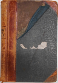
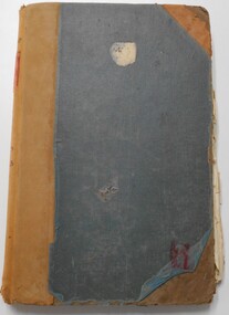
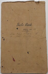
Document - LANDS OFFICE: SANDHURST AND DISTRICT LAND SALES BY PUBLIC AUCTION 1859 - 60
Document: booklet, brown heavy paper cover bound secured with white cotton. Blue paper pages. On front cover ' Sale Book 1859, 60, 61. From August 16th. 1859 to Feb. 26 1861' Contains newspaper cuttings of crown land sales held in Sandhurst. Alongside cuttings are columns: price per acre, amount, purchasers. White sticker fixed to pocket: Book 7 Sandhurst Land Sales 16 August 1859 to March 1861Lands Officebendigo, land sales 1859 - 60, lands office, sandhurst, crown land, auctions -
 Bendigo Historical Society Inc.
Document - LANDS OFFICE, INDEX OF CORRESPONDENCE INWARDS 1867, 1967
Journal: green hard covered journal with buff spine and corners. Contains details of inward correspondence 1967 onwards. Index in front of journal A-Z. Section after index has columns, local office No., date received, name, subject, instructions, how disposed of. On front '11' in black ink. On spine 'QQ' on white label.Lands officeplace, lands office, bendigo, sandhurst, correspondence, land sales -
 Bendigo Historical Society Inc.
Document - LANDS OFFICE: REPORTS OF LAND SALES BY AUCTION 1876 - 1891, 1876 - 1891
Document: green hard cover journal, buff spine and corners. Contains details of land sales by public auction Kerang, Swan Hill and Boort. m LH page ' Lot, County, Town or parish, section, allotment, sold, unsold, why not sold, upset price, sold per acre. RH page: value of improvements, name of purchaser, residence, deposit forfeited, total amount. On spine in gold lettering ' report of sales by auction' underneath 'land sales' in black. No. 6 on top of spine, letter K on base.Lands Officeland sales, kerang, swan hill, boort, sandhurst, lands office -
Port Melbourne Historical & Preservation Society
Document - Notice, Auction, Crown Lands, 1892
Auction notice of Crown lands, 1892town planning, land sales -
University of Melbourne, Burnley Campus Archives
Plan - Coloured plan, Plan of Burnley Gardens, 1929?
Layout of gardens, farm buildings, orchard, etc. overlaid on part of Lands Department map. See paper catalogue for full descriptionPart of larger plan (Lands Department Parish Plan). Partly hand-drawn. Area bounded by Yarra River, Swan St, Glen Iris railway line. Shows Burnley Gardens layout, handwritten amendments and explanation of existing and proposed structures including: Pavilion, sketch of unbuilt Administrative Building, poultry yard, contours of old orchard, sketch for Plant Research Institute, ditch, silo, milking shed, laying pens. See aboveburnley gardens, pavilion, burnley school of horticulture, farm buildings, poultry -
Port Melbourne Historical & Preservation Society
Document - Notice, Attendance at deputation to Public Work re Williamstown Road grant, Edward Clark, Town Clerk, 27 Jan 1880
Pinned with item 600.02Small (4pg) notice inviting attendance at deputation to Minister of Lands, 28 January 1880 re sale of lands along Williamstown Short Road'(Copy)'town planning, edward clark, town clerks, george f smith, land sales