Showing 5971 items
matching later years
-
 Queenscliffe Maritime Museum
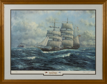
Print - Reproduction print, framed, Oswald L Brett, Barque James Craig 1874, 1974
... years James Craig was used as a collier and later laid up... cargo, in later years James Craig was used as a collier ...Built in 1874 in Sunderland England she was employed carrying cargo around the world and rounded Cape Horn 23 times in 26 years. In 1900 she was acquired by Mr J J Craig, renamed James Craig in 1905 and began to operate between New Zealand and Australia until 1911. Unable to compete with freight cargo, in later years James Craig was used as a collier and later laid up, then used as a hulk, until eventually being abandoned at Recherche Bay in Tasmania. In 1932 she was sunk by fishermen who blasted a 3-metre hole in her stern. Restoration of James Craig began in 1972, when volunteers (now the Sydney Heritage Fleet) refloated her and towed her to Hobart for initial repairs. Brought back to Sydney under tow in 1981, her hull was placed on a submersible pontoon to allow work on the hull restoration to proceed. Over twenty-five years, the vessel was restored and relaunched in 1997. In 2001 restoration work was completed and she continues to go to sea.Mr Robeert Greenway A framed reproduction of a painting by Oswald L Brett on canvas paper of the Barque James Craig 1874 Barque James Craig 1874. Images of two flags; a red ensign and a ships flag 'Craig'; Oswald L Brett N.Y. 1978 james craig, windjammers, barque -
 Brighton Historical Society
Clothing - Nightgown, Mid 19th Century
... in 1867. In later years St Ninians was subsequently subdivided... in 1867. In later years St Ninians was subsequently subdivided ...This nightgown is believed to have belonged to Mrs Thomas Anne Ward Cole, an early Brighton resident and wife of George Ward Cole. The item appears to have been made or altered to accommodate a pregnant belly, however purpose made maternity clothing was not common at this time. Mrs Ward-Cole’s six pregnancies took place in 1843, 1844, 1845, 1847, 1849 and 1851. The style of this garment in particular the shape of the sleeves would indicate that it is most likely to have been constructed in circa 1860, so whilst it appears to be a maternity item, and historically has been referred to as thus, this purpose cannot be confirmed. George Ward Cole was an early member of the Victorian Parliament and the family featured prominently in Melbourne Society in their time. They established a substantial home known as “St Ninians” at 10 Miller Street in 1841. The family reportedly entertained Melbourne’s first Royal visitor The Duke Of Edinburgh, Queen Victoria’s second son, at St Ninians in 1867. In later years St Ninians was subsequently subdivided and later demolishedA hand sewn ivory cotton muslin nightgown, c. 1842–1850. The bodice is made of delicately embroidered muslin in a floral design. The open flat collar features a scalloped lace frill underneath. The bodice fastens with thirteen mother of pearl buttons down the centre front. After the fourth button, the remaining buttons are concealed beneath a full gathered modesty skirt, which falls from just below the bust line. The modesty panel is secured horizontally across the bodice by six mother of pearl buttons. The sleeves finish over the back and palm of the hand in two flattened peaks. The front of the gown consisting of the modesty front is full length. The modesty gown at both sides joins two panels that are an integrated part of the bodice. At the centre back there is a very full gathered panel with lace trim that falls to create a train. It is semi-attached to the bodice with a top section secured with mother of pearl buttons and small ties. The purpose of this design feature is unknown. st ninians, george ward cole, brighton, night gown, thomas anne ward cole -
 Falls Creek Historical Society
Booklet - Australian Ski Year Book 1981 Resort Guide
... in Australia. In later years organisations from Victoria, Tasmania... in Australia. In later years organisations from Victoria, Tasmania ..."The Australian Ski Year Book" was first published in 1928 by the Kosciusko Alpine Club and the Ski Club of Australia, which with the Kiandra Ski Club, were the oldest organisations for skiing in Australia. In later years organisations from Victoria, Tasmania and New Zealand were included. It was published on behalf of N.S.W. Ski Council, Ski Club of Victoria, Ski Council of Tasmania, Ski Council of the Federated N.Z. Mountain Clubs. It aimed to provide an annual record of the sport of ski running in Australia, and of events elsewhere which would be of interest to Australian ski enthusiasts. This publication was a guide to all major resorts operation at the time in New South Wales, Victoria and Tasmania. Information about Falls Creek included a description of its location describing geographical features, its 12 ski tows and available services. The accommodation advertised included Winterhaven Lodge, Falls Creek Motel, Spargo's Lodge, Attunga Alpine Lodge, Nelse Alpine Lodge, Les Chalets, Julian Lodge and Koki and Karelia Alpine Lodges.This item is significant because it is an issue of a long-running Australian ski publication which includes items about Falls Creek, Victoria..The Australian Ski Year Book Resort Guide of 1981 includes information and advertising about resorts throughout Australia. Falls Creek information and Accommodation Guide featured on pages 10 & 11 of this issue.australian skiing, accommodation falls creek, falls creek resort -
 Kew Historical Society Inc
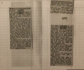
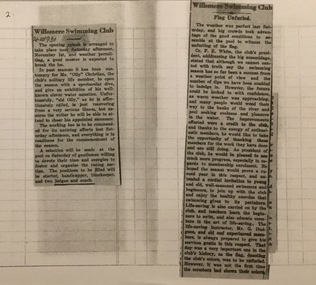
Newspaper - Articles, Willsmere Swimming Club, 1930
... years later. In his final years, he was celebrated as one... in Bulleen Road by 1858 but was declared insolvent two years later ...Henry Christian (c.1809-91) was one of the first settlers in Kew. He arrived in Victoria with his wife Agnes and son Orlando in 1855 on the Gypsy Queen. He established a rope-making business in Bulleen Road by 1858 but was declared insolvent two years later. In his final years, he was celebrated as one of the oldest living settlers of the district. His son, Orlando Henry Beater Christian (c.1853-1930) became a member of the Hawthorn Band and a foundation member of the Willsmere Swimming Club. Three newspaper articles relating to the Willsmere Swimming Club of which ‘Olly’ Christian was the only life-member. Also of his death in 1930. orlando henry beater christian, willsmere swimming club, christian-washfold collection -
 Kew Historical Society Inc
Newspaper - Articles, Willsmere Swimming Club, 1930
... years later. In his final years, he was celebrated as one... in Bulleen Road by 1858 but was declared insolvent two years later ...Henry Christian (c.1809-91) was one of the first settlers in Kew. He arrived in Victoria with his wife Agnes and son Orlando in 1855 on the Gypsy Queen. He established a rope-making business in Bulleen Road by 1858 but was declared insolvent two years later. In his final years, he was celebrated as one of the oldest living settlers of the district. His son, Orlando Henry Beater Christian (c.1853-1930) became a member of the Hawthorn Band and a foundation member of the Willsmere Swimming Club. Two newspaper articles about the Willsmere Swimming Club and ‘Olly’ Christian. orlando henry beater christian, willsmere swimming club, christian-washfold collection -
 Federation University Historical Collection
Map, Municipality of Ballarat East, 1857
... was created six years later and names some of the great gold locations... was discovered in Ballarat in 1851. This plan was created six years later ...Gold was discovered in Ballarat in 1851. This plan was created six years later and names some of the great gold locations of Ballarat East. It also shows the locality of the Eureka Stockade (1854) and the walking tracks and roads on the Ballarat East Goldfield.In 2007 this map was listed on the inaugural Ballarat Treasure's Register.Large map backed onto linen. The map has read and blue highlights, and identifies areas such as Mount Pleasant, Golden Point, White Flat, Nightingale, Malekoff, Old Post Office Hill, Red streak, Gumtree Flat, Old Gravelpits, Bakery Hill, Ballaarat Flat, The Camp, Specimen Gully, Pennyweight Hill, Warrenheip Gully, Gays Gully, Pennyweight Flat, Eureka, Black Hill, Pinchgut, Crocodile, Hit or Miss, Little Bendigo, Brown Hill, Mopoke, Cricket Reserve, Canadian Hotel, Ballarat Eastmount pleasant, golden point, white flat, nightingale, malekoff, old post office hill, red streak, gumtree flat, old gravelpits, bakery hill, ballaarat flat, the camp, specimen gully, pennyweight hill, warrenheip gully, gays gully, pennyweight flat, eureka, black hill, pinchgut, crocodile, hit or miss, little bendigo, brown hill, mopoke, cricket reserve, canadian hotel, ballarat eastm phillips, john phillips, field draughtsman, ballarat east, ballarat east map -
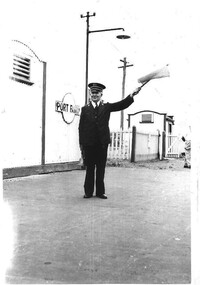 Hymettus Cottage & Garden Ballarat
Photograph, Port Fairy Station
... station was closed twenty years later in 1977.... Fairy Railway station was closed twenty years later in 1977 ...The photograph shows the station master Mr John (Jack) Taffe at Port Fairy, Victoria in the late 1950s signalling for the train to depart using flag and bell. The Port Fairy Railway station was closed twenty years later in 1977.port fairy, railway history, taffe, stationmaster, railway station closures, trains, train station. -
 Warrnambool and District Historical Society Inc.
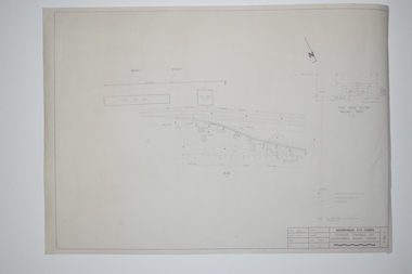
Documents, WCC Proposed turntable site railway station, 1968; 1989
... building was erected a few years later. ... a few years later. These plans, being copies, are of minor ...These two plans are copies and show drawings for a proposed turntable at the Warrnambool Railway Station and railway crossings at Gilles Street in the Liebig Street precinct. The Warrnambool Railway was opened in 1890 and the Warrnambool Railway Station building was erected a few years later. These plans, being copies, are of minor interest as they show plans of some projects in the Warrnambool Railway Station precinct in the latter half of the 20th century.These are two sheets of cream-coloured paper with plans (copies of original) drawn up in black ink. The drawings are fading somewhat and are faint in places. One sheet (.2) has a piece missing from the top left hand corner. .1 ‘Locality Plan of Rail Crossings Liebig St. & Gillies (sic) St.’ .2 ‘Proposed Turntable Site Warrnambool Railway Station’ plans, warrnambool railway, warrnambool rail turntable -
 Lara RSL Sub Branch
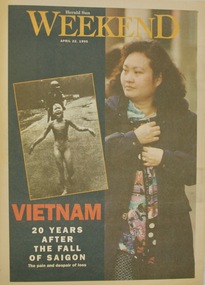
Newspaper - Herad Sun Weekend dated 22/4/1998 - Vietnam 29 years After Te Fall of Saigon, Herald Sun Weekend dated 22/4/1998, 22/04/1995
... years later. ... of the young girl as a woman 20 years later. herald sun weekend vietnam ...This article was referring to a historical event from Vietnam War of a picture depicting the use of napalm and it's effects on people especially the young naked girl running from the Napalm. Alongside the picture of the young girl as a woman 20 years later. Herald Sun Paper supplement five double pagesHerald Sun Weekend, April 22nd, 1995, Vietnam 20 Years After The Fall of Saigon, The pain and despair of loss written on the front page with 2 photos one of young naked girl running from Napalm and her now as a grown woman. herald sun, weekend, vietnam, newspaper, 1995 -
 Learmonth and District Historical Society Inc.
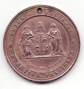
Medal - Queen Victoria 1897, Queen Victoria Diamond Jubilee 1837-1897, Circa 1897
... as the monarchy for 60 years. She died four years later in 1901... Victoria reigning as the monarchy for 60 years. She died four years ...To mark the diamond jubilee of Queen Victoria reigning as the monarchy for 60 years. She died four years later in 1901. These medals were mass produces by Stokes & Sons of Melbourne, many of the local government bodies had them made.Marking the 60 years that Queen Victoria was on the throne. A round medal with a young and older faced Queen Victoria on one side. And on the other side is the Shire of Ballarat 's "Coat of Arm". This medal was issued by the Ballarat Shire as did many of the local government bodiesThe two faces of Queen Victoria, one as a young woman, the other later in life with the words, "QUEEN VICTORIA'S 60th YEAR OF REIGN. 1837 TO 1897". On the front. On the back is written "SHIRE OF BALLARAT. E.BUTLER. PRESIDENT". Also there is the Ballarat Shire "Coat of Arms", written underneath is the words "BY THESE WE FLOURISH".queen victoria, shire of ballarat, diamond jubilee -
 Ringwood and District Historical Society
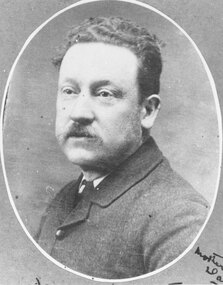
Photograph, James Handforth, father of Katherine, wife of Louis Herry, formerly of Walhalla and Cheshire, England. c1880
... at Walhalla in 1879. In later years Elizabeth, Minellia, Louis... at Walhalla in 1879. In later years Elizabeth, Minellia, Louis ...Black and white photographWritten on backing sheet, "James Handforth, father of Katherine, wife of Louis Herry, formerly of Walhalla and Cheshire, England". From the Place of Many Eagles book, "Louis was born in Purdu, France, in 1855, and came to Ringwood from Walhalla in 1887 and erected a weatherboard house and shop opposite the Club Hotel, using a Miner's Right to secure the land. When he arrived, Louis was a married man with three children, Leopold (1882), Marie (1884), John (1886). He had married Kate Handforth at Walhalla in 1879. In later years Elizabeth, Minellia, Louis and Denise were born. Kate's father was known as the midwife of the Gippsiand township because he had once been a fourth year medical student in England, but earnt a living as a goldbuyer in Victoria. Marie Herry would grow up remembering her grandfather calling sometimes at Ringwood; he would bring the children jubilee Mixture to eat and he carried a revolver in his pocket. Often he would play the violin while Marie would stepdance on the kitchen table." -
 Kiewa Valley Historical Society
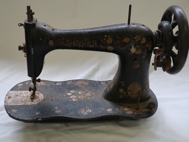
Sewing Machine - Singer
... common during the late Victorian years (up to 1901). This machine... common during the late Victorian years (up to 1901). This machine ...Singer began to market its machines internationally in 1855. They began mass-producing domestic electric machines in 1910. Treadle machines were powered mechanically by a foot pedal that is pushed back and forth by the operator's foot. There were also machines belt powered, hand powered and eventually electric powered. Treadle machines were made into the 1950s but they were most common during the late Victorian years (up to 1901). This machine is c1894.This machine was owned and used by a resident of the Kiewa Valley. It was used for domestic sewing such as for making clothes for the family, making toys for eg. a fete and making useful items eg. a bag for school readersSinger Fiddle Base treadle sewing machine with decoration of flowers. Straight stitch. No stand. A little rusty.Top: 'the Singer Manufacturing'. Front: 'Singer' and the Metal Plaque 'The Singer MFC Cony'singer manufacturing co., clothes, sewing, domestic -
 Kiewa Valley Historical Society
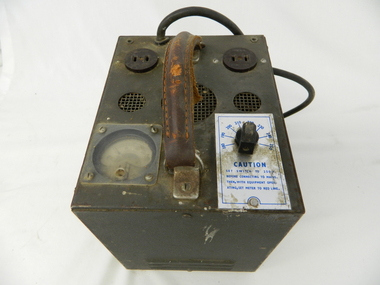
Transformer Lamp System, late 1950's
... diversity of later years.... diversity of later years. This transformer lamp is very significant ...This transformer lamp system, which has a dial to transform 240 volts to a minimum of 32 volts was used by electrical technicians to inspect internal parts of the large generators (even in small confined spaces). The reason for the reduction of the 240 volts to the 32 volts was for the safety of the inspector. The SEC Victoria Hydro Scheme's electrical generators are powered by the hydro force of "stored" water at a higher altitude. The establishment of both the NSW and Victorian Hydro schemes was achieved from the mid 1900's to the 1960's. At this the point in time the need for additional power sources to quench both an industrial and domestic demand for electricity was purely an economic and not and environmental (carbon reduction) factor. This hydro scheme was instigated by "the Government of the day" as a bold move and was the major force of the World War II refugee and "technical" workforce inclusion of skilled and unskilled migration into the Australian environment. Although this mass "invasion" of workers with families was thought of in some circles as intrusive, the expansion of population post war years and its integration into the Australian rural sector, produced the multi- lingual multi-cultural diversity of later years.This transformer lamp is very significant to the Kiewa Valley as it was introduced as a very small part of the explosion of human resources into the valley. This influx of population transformed the region from that of a basically quiet rural region to one which evolved into both industrial and larger residential community. This evolution in the valley created a change, not only in the "physical" landscape but also the socio-economic expansion which permitted other "tourist" based industries into the valley. This is also a specific electronic item which was manufactured in Melbourne and not sourced from Europe or Asia. This demonstrates the fast evolution of Australian technology to a high standard compatible to that of the rest of the world.This heavy hand held electrical transformer (transforms 240 volts to 32 Volts) an has one leather handle on the top with three small (gauze filtered) air holes. It also has two 2 pin directional cable distribution (clipsal) in/out points 10amps / 240 volts. There is one glassed in volts/ac meter and one variable switch (180 to 150 voltage in settings of 10 volt increments.There are two vents (one on each of the smaller sides). There is also one three pin electrical lead coming out from the top.On one side is a manufacturer's plaque with "ELECTRONIC A & R EQUIPMENT MELBOURNE" and underneath "TYPE 1719, PRI V. 180 250" underneath "V.A. 1250" underneath "CYC 50" underneath "SEC V. 115" underneath "SEC A. 10 . 8". The label on topside "CAUTION SET SWITCH TO 250 v BEFORE CONNECTING TO MAINS THEN, WITH EQUIPMENT OPERATING, SET METER TO RED LINE.kiewa hydro electricity scheme, victorian state electricity commission, transformers -
 Eltham District Historical Society Inc
Photograph, Liz Pidgeon, Heritage Excursion; East of Eltham, 6 Sep 2014, 20 May 2017
... . In later years it has been subdivided for residential purposes.... In later years it has been subdivided for residential purposes ...Newsletter No. 218, September 2014 September Excursion - East of Eltham Walk In Newsletter No. 197, March 2011, there was a brief history of Crown Allotment 15 Section 5 Parish of Nillumbik (CA 15) a parcel of land of a quarter of a square mile extending from Eucalyptus Road to Reynolds Road at the eastern extremity of Eltham. From the 1940s it was known as Stokes orchard. In later years it has been subdivided for residential purposes but leaving significant areas as power line and water supply reserves and bushland reserves that are habitat for the threatened For our excursion on 6th September we intend to walk through CA 15 to a bushland reserve east of Reynolds Road. The walk will traverse the boundary between suburban Eltham and the non-urban areas to the south and east. This is a pleasant walk through residential areas and bushland. Along the way we will discuss the early and more recent history of CA 15 as well as local natural history and geology. This walk is about 3.5 km in length and will take 2 to 2.5 hours. It will start at 2pm at the corner of Eucalyptus Road, Pitt Street and Nyora Road.Born Digitaleltham east, eltham district historical society, heritage excursion, activities, nyora road, reynolds road, gum tree road reserve, diosma road, stokes orchard, eucalyptus road -
 Eltham District Historical Society Inc
Photograph, Liz Pidgeon, Heritage Excursion; East of Eltham, 6 Sep 2014, 20 May 2017
... . In later years it has been subdivided for residential purposes.... In later years it has been subdivided for residential purposes ...Newsletter No. 218, September 2014 September Excursion - East of Eltham Walk In Newsletter No. 197, March 2011, there was a brief history of Crown Allotment 15 Section 5 Parish of Nillumbik (CA 15) a parcel of land of a quarter of a square mile extending from Eucalyptus Road to Reynolds Road at the eastern extremity of Eltham. From the 1940s it was known as Stokes orchard. In later years it has been subdivided for residential purposes but leaving significant areas as power line and water supply reserves and bushland reserves that are habitat for the threatened For our excursion on 6th September we intend to walk through CA 15 to a bushland reserve east of Reynolds Road. The walk will traverse the boundary between suburban Eltham and the non-urban areas to the south and east. This is a pleasant walk through residential areas and bushland. Along the way we will discuss the early and more recent history of CA 15 as well as local natural history and geology. This walk is about 3.5 km in length and will take 2 to 2.5 hours. It will start at 2pm at the corner of Eucalyptus Road, Pitt Street and Nyora Road.Born Digitaleltham east, eltham district historical society, heritage excursion, activities, nyora road, reynolds road, gum tree road reserve, diosma road, stokes orchard, eucalyptus road