Showing 6986 items
matching level-crossing
-
 City of Ballarat
Artwork, other - Public Artwork, Ratartat, Crossing Rubicon, 2008
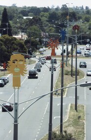
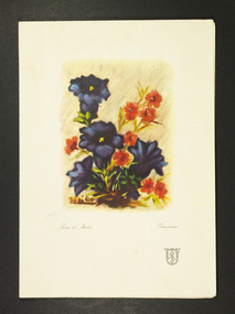
“This public art project honours the people and suburb of Sebastopol, as well as providing a strong visual identity for Albert Street. It will make the street a lot more attractive and welcoming. The project is the outcome of extensive consultation with groups and individuals in the Sebastopol community, who have made suggestions both as to the nature of the project but also the aspects of life in their community they wanted to represent through the artwork.”Crossing Rubicon by Ratartat is located in Albert Street, Sebastopol, Ballarat. A row of 16 lampposts in Sebastopol’s main street are topped with large enamelled steel sculptures of trees, representing different aspects of Sebastopol’s community life and history. Ratartat is an artistic collaboration of Ballarat-based artists Geoff Bonney and Pete Widmer. The name, Crossing Rubicon, refers to Rubicon Street, the boundary between Redan and Sebastopol. The street was named after the Rubicon River, an ancient boundary between Italy and Gaul. Julius Caesar’s decision to cross the river, thereby rebelling against the Roman Senate, gave rise to the expression “crossing the Rubicon”, meaning going past the point of no return.Sixteen powder-coated steel sculptures mounted on light polesrubicon, sebastopol, ratartat -
 Greensborough Historical Society
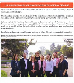
Article - Newsletter Clipping, Colin Brooks, $2.8 million secured for Diamond Creek Road pedestrian crossing, May 2024
Article from Brooksy's Briefing about funding for a pedestrian crossing between St. Helena Road and the Civic Drive roundabout in Greensborough.Newsletter article, text with colour imagest helena road greensborough, civic drive greensborough, colin brooks -
 Whitehorse Historical Society Inc.
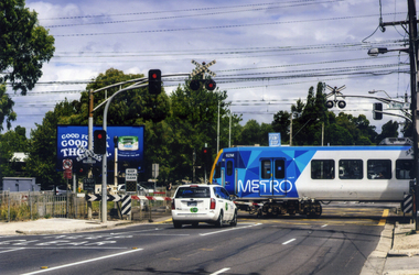
Photograph, Mitcham Railway Crossing
Coloured photograph of a Metro train crossing Mitcham Road and heading east towards Ringwood - 2012. In 2013, due to the amount of traffic using Mitcham Road, the railway line and station were reconstructed underground.mitcham railway crossing, trains, railways, transport -
 Orbost & District Historical Society
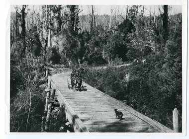
black and white photograph, 1913
This photograph is of the low level bridge across the Bemm River about 50 km east of Orbost in East Gippsland.This is a pictorial record of the 1913 low level bridge across the Bemm River, East Gippsland.A large black / white photograph of a horse - drawn wagon on the low level Bemm River bridge. In the foreground on the bridge is a dog.on back - "Country Roads Board Princes Highway low level bridge" -
 Stawell Historical Society Inc
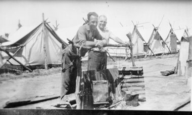
Photograph, Deep Lead -- Bunyip Bank Rail Crossing with 2 men near a fire in front of row of tents where workers were housed
Deep Lead Bunyip Bank Rail Crossing. Two men near fire in front of row of tents where workers were housed.stawell transport railways -
 Vision Australia
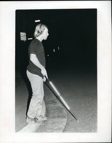
Photograph - Image, Man crossing street using white cane at night
A man uses a white cane crossing a street at night in Newcastle. His cane reflects the photographer's flash and is illuminated against the dark night.Black and white photograph of a man using a white cane at nightOrientation and mobility at night - Newcastle Please return to RBSwhite cane day, royal blind society of new south wales -
 Eltham District Historical Society Inc
Postcard - Photograph postcard, Old Bridge, Kaylock's Crossing, Brougham Street, Eltham, c.1912
Date estimated to be circa 1912 based on the style of printing on the reverse of the card - Kodak Austral paper for real photo postcards, the paper was manufactured c.1908-1914 (See also POSTCARDS ON KODAK PAPER - IS IT POSSIBLE TO "DATE" THEM? http://tps.org.au/bb/viewtopic.php?t=115) Brougham Street was created in Josiah Holloway's 1851 subdivision of Little Eltham. It was one of several east-west streets shown on the subdivision plan as crossing the Diamond Creek. The western part was named Wellington Street on the subdivision plan but was later changed to conform with the name of the eastern part as acknowledgement of the continuity of the street. It is not known when the first bridge was constructed in Brougham Street however it was certainly mentioned at Council’s meeting of 2 June 1884 as being in a dangerous state of repair. This photo (c.1895) of an old bridge shows a very low-level simple log girder bridge crossing the creek at a right angle and so the approaches involved bends in the road alignment. This bridge was generally known as Kaylocks Bridge or Kaylock’s Crossing after the owner of the adjoining land. It was most likely built from around the mid-1850s, or a crossing of some fashion established as Richard George Kaylock, butcher of Little Eltham and his wife Emily Ann settled there in 1854. His property was in Wellington Street (now Brougham Street) and apparently extended across the Diamond Creek. The land on the western side of the creek was farmed, the house being on the eastern side. Kaylock's Bridge formed part of the original coach road to Eltham and in 1922 was described as an "old rustic bridge". Its low level and insubstantial construction made it susceptible to flood damage, necessitating frequent closures until repairs could be carried out. In September 1922, Council called for tenders for a new timber bridge to be constructed at Kaylock’s crossing. An engineering assessment carried out for the Council by Macleod Consulting at the time of the replacement suggested that the construction details indicate that it was in the 1900s, however this dating could possibly have been the result of numerous repairs undertaken over the years to flood damage. The tender was awarded to Mr Weller of Kangaroo Ground who commenced work in February 1923 on a higher-level timber trestle bridge. Work was slowed due to illness of the contractor and the accidental death of a man in March 1923 following the collapse of the bank after he had jumped into a hole that had just been blasted. The bridge was completed around July 1923 at which point the old structure was pulled up, marking what was described in the ‘Advertiser’ newspaper as the passing of an old and well-loved landmark in the district. In April 1924 the approach to Kaylocks bridge was washed away during the heavy flooding that destroyed the Main Road bridge. The western side was repaired, and an extra span was added to the eastern side using timber from the destroyed Main Road bridge. The bridge was again severely damaged four months later in August 1924 When a lack of finances delayed repairs to the Bridge Street bridge in 1931 (also referred to as Obelisk Bridge at the time), traffic had to detour via Brougham Street for some time. Local residents feared that the Bridge Street bridge might never reopen. Kaylocks Bridge was constantly subject to damage by floods. In the 1934 flood it was submerged by two feet of water. In more recent times the bridge was again severely damaged by flooding and repairs made. A new bridge and adjoining footbridge were constructed in 2009.Digital file only Postcards scanned from the collection of Michael Aitken on loan to EDHS, 2 Sep. 2022michael aitken collection, eltham, postcards, bridge, brougham street, diamond creek (creek), kaylocks bridge, wellington street -
 Eltham District Historical Society Inc
Photograph, Old Bridge, Kaylock's Crossing, Brougham Street, Eltham, c.1895
Brougham Street was created in Josiah Holloway's 1851 subdivision of Little Eltham. It was one of several east-west streets shown on the subdivision plan as crossing the Diamond Creek. The western part was named Wellington Street on the subdivision plan but was later changed to conform with the name of the eastern part as acknowledgement of the continuity of the street. It is not known when the first bridge was constructed in Brougham Street however it was certainly mentioned at Council’s meeting of 2 June 1884 as being in a dangerous state of repair. This photo (c.1895) of an old bridge shows a very low-level simple log girder bridge crossing the creek at a right angle and so the approaches involved bends in the road alignment. This bridge was generally known as Kaylocks Bridge or Kaylock’s Crossing after the owner of the adjoining land. It was most likely built from around the mid-1850s, or a crossing of some fashion established as Richard George Kaylock, butcher of Little Eltham and his wife Emily Ann settled there in 1854. His property was in Wellington Street (now Brougham Street) and apparently extended across the Diamond Creek. The land on the western side of the creek was farmed, the house being on the eastern side. Kaylock's Bridge formed part of the original coach road to Eltham and in 1922 was described as an "old rustic bridge". Its low level and insubstantial construction made it susceptible to flood damage, necessitating frequent closures until repairs could be carried out. In September 1922, Council called for tenders for a new timber bridge to be constructed at Kaylock’s crossing. An engineering assessment carried out for the Council by Macleod Consulting at the time of the replacement suggested that the construction details indicate that it was in the 1900s, however this dating could possibly have been the result of numerous repairs undertaken over the years to flood damage. The tender was awarded to Mr Weller of Kangaroo Ground who commenced work in February 1923 on a higher-level timber trestle bridge. Work was slowed due to illness of the contractor and the accidental death of a man in March 1923 following the collapse of the bank after he had jumped into a hole that had just been blasted. The bridge was completed around July 1923 at which point the old structure was pulled up, marking what was described in the ‘Advertiser’ newspaper as the passing of an old and well-loved landmark in the district. In April 1924 the approach to Kaylocks bridge was washed away during the heavy flooding that destroyed the Main Road bridge. The western side was repaired, and an extra span was added to the eastern side using timber from the destroyed Main Road bridge. The bridge was again severely damaged four months later in August 1924 When a lack of finances delayed repairs to the Bridge Street bridge in 1931 (also referred to as Obelisk Bridge at the time), traffic had to detour via Brougham Street for some time. Local residents feared that the Bridge Street bridge might never reopen. Kaylocks Bridge was constantly subject to damage by floods. In the 1934 flood it was submerged by two feet of water. In more recent times the bridge was again severely damaged by flooding and repairs made. A new bridge and adjoining footbridge were constructed in 2009. Part of a slide show presentation "Bridges & Waterways of the Shire" by Russell Yeoman to the 13 September 1989 Society meeting. The presentation included slides of historic photos from the Shire of Eltham Pioneers collections as well as several recent views.Photo of earliest known crossing of the Diamond Creek at brougham StreetPostcard photo printbrougham street, eltham, wellington street, kaylocks bridge, bridge, diamond creek (creek) -
 Ballarat Tramway Museum
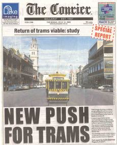
Newspaper, The Courier Ballarat, "Return of trams viable study", "New Push for Trams", "Taking tourism to the next level", "More tourists, more jobs expected", "Tram plan worthy of expected debate", 11/07/2002 12:00:00 AM
Set of three cuttings from The Courier, Ballarat dated Thursday 11/7/2002 regarding the reintroduction of trams to Ballarat. 2241.1 - Page 1 and 2 of The Courier, with page 1 titled "Return of trams viable study" and "New Push for Trams" as the commencement of a Special report showing a digitally constructed image of No. 13 in Lydiard St. North. Note the tram does not have a driver. Introduces reports by Alex Easton on pages 2, 6 and 7. On Page 2, titled "Taking tourism to the next level", has details of the Council viewpoints on the proposal, public consultation, a map of the route, and notes on the construction issues. Has a digital image of 13 crossing Sturt St. into Lydiard St. North. See images No. 1 to 3. 2241.2 - page 6 of The Courier, which joins with page 7 using the titled "More tourists, more jobs expected". Has Sections reviewing the study outcomes, benefits and a summary of the study. Page 6 has a photo of a passenger boarding No. 21, decorated as the Myers Christmas tram in Sturt St and a photo of Bridge St. in 1971 (very poor quality reproduction). See images No. 4 and 5. 2241.3 - page 7 of The Courier, has Sections detailing the history of Ballarat Trams, proposals for the City Tramway, costs, consultation, and comments from Peter Hiscock. Has a photo of Peter Hiscock and Mayor David Vendy in front of No. 13 at the BTM depot. See image No. 6. Also has a photo of Dianne Smith, Executive Director of Ballarat Tourism. On page 8, as part of The Courier's editorial Section, has comments on the proposals, titled "Tram plan worth of extended debate". Looks at the $20million cost. ballarat revival, editorial, ballarat city tramway, lydiard st. nth -
 Melbourne Tram Museum
Document - Research Notes, H. S. McComb, cable tram crossing with the Northcote Brick Company - part 1, 1937
Correspondence and notes between the City of Northcote and the MMTB regarding the cable tram crossing with the Northcote Brick Company private siding at Langwell's Parade. Dated 1937. Copy of the Agreement provided by the City of Northcote. Multiple copies of some of the documents. Handwritten letter on MMTB letterhead, to the Northcote Brick Company regarding the cost of repairs to the tramway and crossing dated 21/1/1921 and a memo dated 16/10/1937. Items 2053 to 2057 within box 72.3 in a brown folder marked "Northcote CC" in red pencil.trams, tramways, northcote, cable trams, railways -
 Mission to Seafarers Victoria
Souvenir - Menu, MV Neptunia Crossing the Line Menu
MV Neptunia ship's menu for the February 1959 equator crossing. Extra historical context by the addition of ship's passengers and crew signing their names and providing contact details. Representative cruise ship paraphernalia of the period, showing the significance and tradition of celebrating a ship's crossing of the equator. Ship's restaurant menu consisting of single folded light card, with vivid watercolour painting of flowers of orange and purple on the front cover. On opening the card, printed menu selection in Spanish is on the left and is in English on the right. Guests and crew have signed randomly over and around the menu listings. menu, crossing-the-line, equator, neptunia, nick garlick -
 Ringwood and District Historical Society
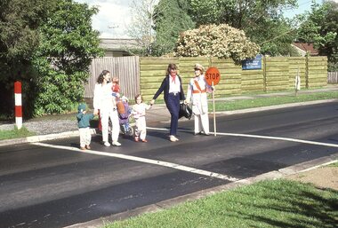
Slide Images, Southwood Primary School (Ringwood) - images from slide show created 1986 - School Crossing
Digital scans of slides of Southwood Primary School prepared by former teacher, Faye Griggs Rogers Guthrie, in 1986 for a University project. See Record 11540 for description of full collection. This record contains digital images of the School CrossingNo identification or dates on individual slides -
 Greensborough Historical Society
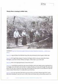
Article and Photograph, Plenty River crossing to Willis Vale, 2016_
Information and photo of members of the Partington family on the log crossing the Plenty River to the family's home at Willis Vale c1905. In the photo are Maria, Prudence and William Partington and Mr Coghill.This photograph and text was copied from a Facebook site. Members are people who lived in the Greensborough area and share their reminiscences of the area with others. The site is administered by a GHS member but is not officially affiliated with the Society. Any information is the opinion of the contributor. Article and photograph sourced from social media.willis vale, partington family, coghill, greensborough -
 Ringwood and District Historical Society
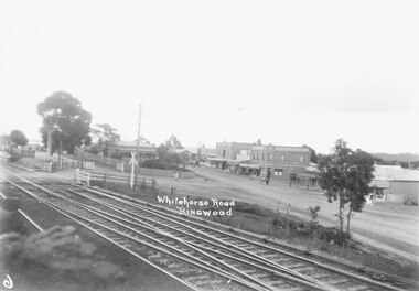
Photograph, Maroondah Highway Central, Ringwood. Whitehorse Road, showing old railway crossing. 1918
Black and white photograph (2 copies)Written on back of photograph: "View showing old rail crossing, Station Master's house and Coffee Palace." Stamp of photographer on back of photograph reads, "T.R.G. Williams, Photographer, Ringwood" -
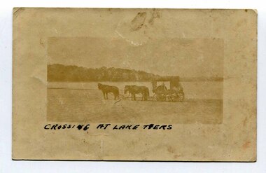 Orbost & District Historical Society
black and white photograph, late 19th - early 20th century
In the late 19th century in the Orbost area roads were just bush tracks which generally were unsuitable for any type of vehicular traffic so were traversed mainly by horseback. As the settlement grew, a weekly mail service from Cunninghame (Lakes Entrance) was estab-lished. The settlers had to carry the mail for three months and each took a turn as mailman during that time. The first coach was driven by Mr Alex Hall. Eventually a daily mail service was set up and many drivers included B. Sutherland, W. Middleton, Jonson Bros., J. Mitchell, F. Newport, J. Geddes, A. Coulson, Bert Cessor, H. Weekes and A. Barthile. (info. from Newletter August 2007) This photograph is one of A. Coulson’s Coach crossing the Sand Bar at Lake Tyers.This is a pictorial record of very early transport in East Gippsland.A very faded small postcard / photograph of a horse and cart crossing a beach.on front in black writing - " Crossing at Lake Tyers" on back - "A Coulson"lake-tyers transport coulson-coaches -
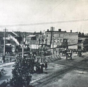 City of Ballarat Libraries
Photograph - Card Box Photographs, Lydiard Street North Railway Station Crossing 1915
Photo of the Lydiard Street North Railway Crossing complete with the railway gates from the Ballarat Homecoming publication. Also seen in the photo is Reid's Coffee Palace and the electric tram line. railway gates, lydiard street north, ballarat, public, reid's coffee palace, railway crossing, streetscape, ballarat homecoming -
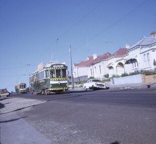
 Ballarat Tramway Museum
Photograph - Digital Image, Peter Knife, Trams 18 and 17 crossing at Gardens Loop, 24/7/1971
Digital image of Trams 18 and 17 crossing at Gardens Loop. Tram 17 has a Twin Lakes and a SEC roof advert. Photo by Peter Knife 24/7/1971.Yields information about tram operations in Ballarat, some two months before closure of the SEC operated tram system.Digital image of a colour slide.tramways, tramcars, ballarat, gardens loop, tram 18, tram 17 -
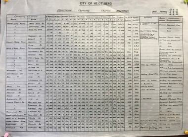 Greensborough Historical Society
Diagram, Pedestrian crossing traffic densities, by City of Heidelberg, 1958_
Readings were taken at 34 pedestrian crossings in the Heidelberg and Greensborough areas, of pedestrians and vehicles at hourly intervals between 8 am and 6 pm on four Fridays in August and September 1958Table of pedestrian counts.traffic, heidelberg, greensborough -
 Melbourne Tram Museum
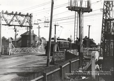
Photograph - NMETL tram 4 Epsom Road level crossing, Victorian Railways, c1919
Photo of the Level Crossing in Epsom Road, Flemington or Ascot Vale showing the overhead arrangement and structures either side of the road to provide power to either the trams or the trains. The small signal box is in the view as well as the interlocked gates. A NMETL saloon tram, No. 4, is crossing the railway lines. Photo late 1919 or 1920. Has the words "VR Tramway Crossing at Epsom Rd showing insulators in tram line and special crossing fitting." The level crossing was electrified on 18-8-1919 and abolished mid 1925 when the underpass was built. See Weekly Notice Extracts 1894-1994, published 1996. See item 8667 for a similar photo with tram 184.Yields information about the Epsom Road level crossing and tram 4.Photograph, Black and White, with notes on the rear.In ink on the rear: "Melbourne - North Melbourne Electric Tramway and Lighting Co. Ltd - No. 4 in Epsom Road on level crossing to Showrooms and Flemington Racecourse. About 1919-1920." Has KSK stamp and Number LWR-4 and CEE 12 in to right-hand corner.trams, tramways, level crossings, nmetl, epsom rd, showgrounds, ascot vale, tram 4 -
 Wodonga & District Historical Society Inc
Photograph - Codling Collection 01 - High Street Wodonga looking south from the railway crossing, 1987
Miss Olive Codling was a Foundation Member and a Life Member of the Wodonga Historical Society. Many of her prize-winning photos are held in the Society Collection. She also held a range of roles and committee positions in a wide range of Wodonga community organisations. These included the Horticultural Society, the Wodonga Arts Council, the Wodonga Camera Club and the Wodonga Lapidary Club. This photo collection is significant as it documents how the businesses and buildings in Wodonga have evolved and contributed to community throughout the 20th century.High Street Wodonga looking south from the railway crossing. Railway boom gate and Wodonga Home Furnishers on the right. Safeway sign in the carpark in the background. The Water Tower is in the distance. The Finishing Touch is on the left. This photo was taken for Heritage Week 1987.wodonga businesses, high st wodonga, railway crossing -
 Ballarat Tramway Museum
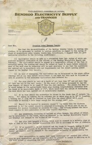
Document - Letter/s, State Electricity Commission of Victoria (SECV), "Crossing Under Tramway Tracks", 1937
Yields information about the correspondence that was sent to various parties about the opening of tram tracks for underground services in Bendigo.Set of four documents: .1 - Letter on SECV letterhead, "Bendigo Electricity Supply and Tramways", not dated, gives phone number, address, duplicated in black ink, titled "Crossing Under Tramway Tracks", consisting of one foolscap sheet. Would have been written as a base letter to go various bodies, has the word "Manager" on the very bottom of the page. Outlines the processes that have to be undertaken in order to install pipelines under tram tracks. Allows for Emergency installations, gives depths and installation requirements. .2 quarto sheet, as a blank form - application form to install the service. .3 - cut sheet - blank form - Permit for Crossings under Tramway Tracks .4 - cut sheet - blank form - "Pipe crossings under tramway tracks" See Reg Item 4945 for Ballarat, possibly used as a model for the Ballarat document, given Reg Item 4943 correspondence and see Reg Item 4947 for cover letter for these documents.in ink "1" and "2" "3" and "4" on sheets in ink and on sheet 4 - change noted re "Technical Assistant"trams, tramways, letters, sec, tram track -
 Eltham District Historical Society Inc
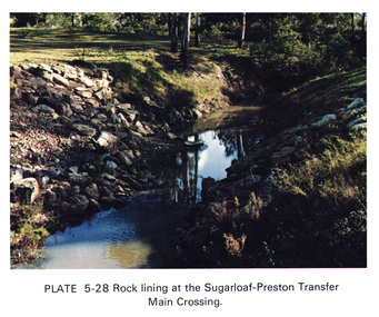
Work on paper (Sub-Item) - Photograph, Rock lining at the Sugarloaf-Preston transfer main crossing, 1976
Colour photograph of rock lining at the Sugarloaf-Preston transfer main crossing. The Sugarloaf Reservoir and the Winneke Water Treatment Plant (Winneke) are located 32 km north-east of Melbourne, near Christmas Hills. rock lining, water supply -
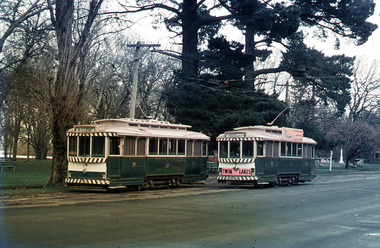
 Ballarat Tramway Museum
Slide - 27 mm sq slide/s, Andrew Howlett, Trams crossing at the Grant St loop, Barkly St Mt Pleasant, Feb or March 1969
Yields information about the Grant St loop on the Mt Pleasant line.Colour slide, Kodak white cardboard mount, developed Mar 1969 of No. 37 (Special) crossing No. 34 (Gardens) at the Grant St loop, Barkly St Mt Pleasant. See Reg Items 7675, 7678, 7681, 7684, 7686, 7705 and 7713.ballarat, tramways, trams, barkly st, tours, grant st, tram 37, tram 34 -
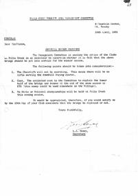 Falls Creek Historical Society
Letter - Circular Downhill Bridge Crossing
Bob (Herman) Hymans (a former member of the Royal Netherlands Navy) was born in Bloemendaal, Holland on 30th September 1922. During World War II he fought against the Japanese in the Dutch East Indies (now Indonesia) and was imprisoned in Changi and on the Burma Railway. After gaining qualifications as a Ski Instructor, Bob arrived in Falls Creek in July 1950. Working as an Instructor and Supervisor at Bogong Lodge, Bob decided his future was in accommodation. He was successful in negotiating an indenture for land from the State Electricity Commission (SEC). It took Bob two years to build his Grand Coeur Chalet but, tragically, it was burned down in August 1961. Bob also built the first Chairlift in Australia. This was a single chairlift and the structure was built from wooden electricity poles. He was constantly full of new ideas and proposals for the village. Bob Hymans died on 7th July 2007. This Collection of documents and letters tells the story of Bob's endeavours to develop Falls Creek into the ski village it is today.This letter is significant because it documents steps taken by the Falls Creek Tourist Area Management Committee to develop and protect the area.A letter dated 12.04.1961. The Management Committee was seeking feedback as to whether the Downhill Bridge Crossing should be put into service during the upcoming winter season. Points to be considered were that the chairlift in the area would not be operating, cost and the fact that no major championships were scheduled.falls creek development, falls creek tourist area management committee -
 National Vietnam Veterans Museum (NVVM)
Photograph, Gibbons, Denis, Crossing the Line 3
Denis Gibbons (1937 – 2011) Trained with the Australian Army, before travelling to Vietnam in January 1966, Denis stayed with the 1st Australian Task Force in Nui Dat working as a photographer. For almost five years Gibbons toured with nine Australian infantry battalions, posting compelling war images from within many combat zones before being flown out in late November 1970 after sustaining injuries. The images held within the National Vietnam Veterans Museum make up the Gibbons Collection. A black and white photograph of Diggers of 9th Battalion, Royal Australian Regiment watching as the courtiers of 'King Neptune' during the 'crossing of the line' ceremony on board the Vung Tau Ferry HMAS Sydney taking the 9RAR for service in Vietnam, and move in procession to the 'King's Throne'.photograph, 9th battalion, 9 rar, vung tau ferry, hmas sydney, gibbons collection catalogue, denis gibbons, photographer, vietnam war, diggers, kings throne -
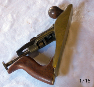 Flagstaff Hill Maritime Museum and Village
Plane, Stanley Rule & Level Co
Plane Jack type maker Stanley with brass body and lever cap, wooden handles and steel irons. Has GTL stamped on blade mechanismflagstaff hill, warrnambool, shipwrecked-coast, flagstaff-hill, flagstaff-hill-maritime-museum, maritime-museum, shipwreck-coast, flagstaff-hill-maritime-village, plane -
 Port Melbourne Historical & Preservation Society
Book, Terry Keenan, "The Road Less Travelled - Port Melbourne Stands Alone", May 2012
Written following the amazing 2011 season and premiership and published the week PMFC won their 28th consecutive match (the next week they lost to Colingwood).Signed copy of "The Road Less Travelled - Port Melbourne Stands Alone" a 148 page paperback by Terry KEENAN. Cover apple green with red, navy and white lettering (colour photograph by David THOMPSON, front and back cover). A coverage of the six stand-alone years for the PMFC, from 2006 to the 2012 undefeated premiership.Signed by author on title pagepeter saultry, terry keenan, gary ayres, pmfc, port melbourne football club, sport - australian rules football -
 Greensborough Historical Society
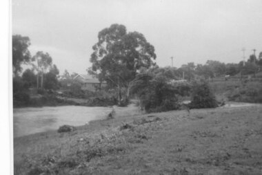
Photograph - Digital Image, Plenty River in flood 1972, view at the Rand Street Crossing, 1972_
Plenty River in flood at the Rand Street Crossing. There were two major floods in Greensborough at the time, 1972 and 1974. Poulter Reserve was created after the 1972 flood and had to be re-established following the 1974 flood.Digital copy of black and white photograph.plenty river, floods -
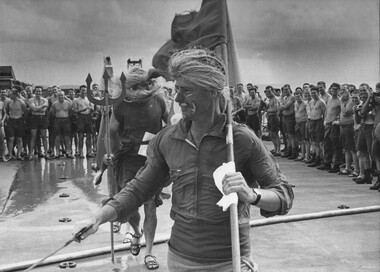
 National Vietnam Veterans Museum (NVVM)
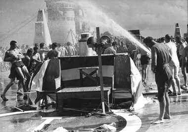
Photograph, Gibbons, Denis, Crossing the Line 2
Denis Gibbons (1937 – 2011) Trained with the Australian Army, before travelling to Vietnam in January 1966, Denis stayed with the 1st Australian Task Force in Nui Dat working as a photographer. For almost five years Gibbons toured with nine Australian infantry battalions, posting compelling war images from within many combat zones before being flown out in late November 1970 after sustaining injuries. The images held within the National Vietnam Veterans Museum make up the Gibbons Collection. A black and white photograph of a digger from 9th Battalion Royal Australian Regiment. He has been 'found guilty' by courtiers of 'King Neptune' during the "crossing of the line" ceremony on board the Vung Tau Ferry, HMAS Sydney taking 9RAR to service in Vietnam.photograph, hmas sydney, 9th battalion, 9 rar, vung tau ferry, crossing the line, gibbons collection catalogue, vietnam war, denis gibbons, photographer, digger, diggers, king neptune -
 National Vietnam Veterans Museum (NVVM)
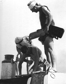
Photograph, Gibbons, Denis, Crossing the Line 1
Denis Gibbons (1937 – 2011) Trained with the Australian Army, before travelling to Vietnam in January 1966, Denis stayed with the 1st Australian Task Force in Nui Dat working as a photographer. For almost five years Gibbons toured with nine Australian infantry battalions, posting compelling war images from within many combat zones before being flown out in late November 1970 after sustaining injuries. The images held within the National Vietnam Veterans Museum make up the Gibbons Collection.A black and white photograph of a digger from 9th Royal Australian Regiment, is found guilty and prepared for his doom by Courtiers of King Neptune during the "crossing of the line" ceremony on board the Vung Tau Ferry, HMAS Sydney, taking the Battalion to war service in Vietnamphotograph, hmas sydney, vung tau ferry, 9 rar, gibbons collection catalogue, digger, the royal australian regiment, courtiers of king neptune, crossing of the line, 9th battalion, denis gibbons