Showing 536 items matching "minerals"
-
 The Beechworth Burke Museum
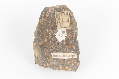
Geological specimen - Porphyritic Rhyodacite
This specimen was recovered from the Nigretta Falls (previously named the Upper Wannon Falls), Victoria. The falls are fed by the Wannon River that has its head waters in the Grampians mountains. Approx. 10km upstream of the Wannon Falls, Nigretta is a multi-channel segmented cascade of smaller drops and bounces guided by patterns of joints in a much older (Devonian) rhyolitic volcanic rock. Both the Wannon and Nigretta Falls are iconic landscape features, entrenched in the history and identity of the region. These falls are particularly rare as they are the product of volcanic activity, which is unique in the context of the Volcanic Plain of Victoria. Waterfalls of this capacity are generally associated with the Uplands areas of Victoria, rather than the edges of the Volcanic Plain. This specimen is part of a larger collection of geological and mineral specimens collected from around Australia (and some parts of the world) and donated to the Burke Museum between 1868-1880. A large percentage of these specimens were collected in Victoria as part of the Geological Survey of Victoria that begun in 1852 (in response to the Gold Rush) to study and map the geology of Victoria. Collecting geological specimens was an important part of mapping and understanding the scientific makeup of the earth. Many of these specimens were sent to research and collecting organisations across Australia, including the Burke Museum, to educate and encourage further study. A solid, dark grey mineral specimen with pale terracotta coloured inclusions. Rhyodacite is a volcanic rock intermediate in composition between dacite and rhyolite. Rhyodacites form from rapid cooling of lava relatively rich in silica and low in alkali metal oxides.GEOLOGICAL SURVEY / R / S 55 FELSTONE PORPHYburke museum, beechworth, indigo shire, beechworth museum, geological, geological specimen, porphyritic rhyodacite, lava, nigretta falls, upper wannon falls, dacite, rhyolite, volcanic geology -
 Stawell Historical Society Inc
Realia, Fossil's
Alan Tangey returned with them after working as a survey technician from Stawell area and given to children.Reputed to be Fossilised Eggs and 8 Pieces of wood, also 1 piece of Fossilsed Coral. Probably Fossilised Plant Roots Formed by Cementing Around Roots by minerals such as Calcium. Coral may have come from coastal survey work or holidays. fossils, children -
 Flagstaff Hill Maritime Museum and Village
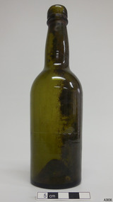
Container - Bottle, 1840s to 1870s
This small green bottle has been handmade by a glassblower and is the typical shape of a carbonated soda or mineral water bottle. It was made from 1840s-1870s. The bottle was found in the coastal waters of Victoria about 100 years from when it was made. It is part of the John Chance Collection. Glassblowers made bottles like this one by blowing air through a long pipe and into molten glass at the end of it. The shape of the glass would be blown out to fit into the shape of the cylindrical dip mould. Once it set, the glass was removed from the mould and the glassblower would continue using the pipe to create the neck and another ponty tool to push up and form the base. The bottle would be cracked off the end of the glassblower’s pipe and a blob of molten glass would be wrapped around the top of the neck and shaped to finish the lip of the bottle. The seal was usually a cork, held in place with a ball-wire fitting attached between the upper and lower parts of the neck finish. This style of handmade bottles usually had thick glass so that it could be heat-sterilised, then re-filled. The bottles would often have horizontal bubbles in the applied finish, caused by twisting the glass, and vertical bubbles and diagonal lines in the body from it being blown, and a pontil mark in the base where the ponty tool had been attached. Although the bottle is not linked to a particular shipwreck, it is recognised as being historically significant as an example of bottles imported for use in Colonial Victoria in the mid-to-late 1800s. The bottle is also significant as it was recovered by John Chance, a diver in Victoria’s coastal waters in the late 1960s to early 1970s. Items that come from several wrecks have since been donated to the Flagstaff Hill Maritime Village’s museum collection by his family, illustrating this item’s level of historical value. Bottle; green glass, soda or mineral water style, handmade. Applied finish, blob double ring collar; upper is wide and rounded, lower is a narrow ring. Diagonal lines in glass on neck and shoulder. Low shoulder mould seam. Body is matt with ripples in glass, tapers inward towards base. Shoulder and neck are shiny. Push-up base with pontil mark, visible through glass. Marks on heel. Uneven base. Bubble on side and top of lip. Sediment on inside surfaces. Two score lines, one half way down body, one near base. flagstaff hill, warrnambool, flagstaff hill maritime museum, maritime museum, shipwreck coast, flagstaff hill maritime village, great ocean road, shipwreck artefact, john chance, glass bottle, antique bottle, handmade, dip mould, mouth blown, pontil mark, 19th century bottle, collectable, soda bottle, mineral water bottle, green glass, blob finish, push-up base -
 Walhalla Museum
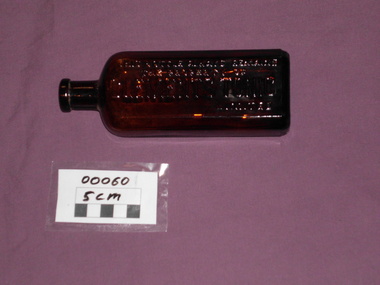
Clements Tonic Bottle, Unknown, circa 1848 to 1950
Used in Victorian psychiatric hospital between 1848 and1950. Clements Tonic contained herbs, vitamins and minerals and was used to improve general well-being. This bottle is rectangular in shape with tapered corners, giving the bottle 8 flat sides and is made from brown glass. The name of the product is molded down the length of the bottle. This bottle always remains the property of CLEMENTE' TONIC Limited -
Federation University Historical Collection
Book, C F Rammelsberg, Handbuch der Mineralchemie, 1860
... minerals ...Brown half leather bound (leather spine) with marbled cover of 1038 pages. Written in German.Signed A Mica Smithminerals, mineralogy, chemicals, mineral analysis, chemical constitution of minerals -
 The Beechworth Burke Museum
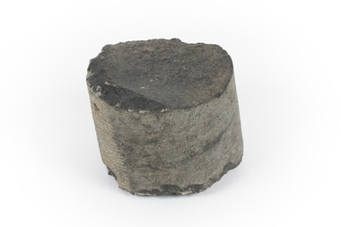
Geological specimen - Basalt
This specimen was recovered from Creswick in Victoria. Basalt is dark in colour, often black and has a fine grain. It is composed of plagioclase and pyroxene minerals and an igneous rock. This specimen is part of a larger collection of geological and mineral specimens collected from around Australia (and some parts of the world) and donated to the Burke Museum between 1868-1880. A large percentage of these specimens were collected in Victoria as part of the Geological Survey of Victoria that begun in 1852 (in response to the Gold Rush) to study and map the geology of Victoria. Collecting geological specimens was an important part of mapping and understanding the scientific makeup of the earth. Many of these specimens were sent to research and collecting organisations across Australia, including the Burke Museum, to educate and encourage further study.A cylindrical fine-grained piece of igneous rockburke museum, geological survey of victoria, geological specimen, geology -
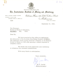
 Federation University Historical Collection
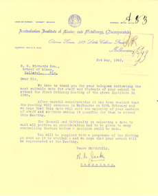
Letter - Correspondence, Miss B.E. Jacka, Secretary of the Australasian Institute of Mining and Metallurgy, Correspondence on Australian Institute of Mining and Metallurgy (Incorporated) Letterhead, 1949, 03/05/1949
The Australasian Institute of Mining and Metallurgy (The AusIMM) was founded in 1893 and provides services to professionals engaged in all facets of the global minerals sector. With a focus on providing leadership and opportunities to minerals industry professionals, the AusIMM delivers an ongoing program of professional development services to ensure our members are supported throughout their careers, enabling them to provide high-quality professional input to industry and the community. (http://www.ausimm.com.au/content/default.aspx?ID=94, Accessed 09 September 2015)Typed letter on the Australian Institute of Mining and Metallurgy letterhead relating to the first Ordinary Meeting of the Institute. The letter is addressed to R.W. (Dick) Richards of the Ballarat School of Mines, and is signed by B.E. Jacka, Secretary of the Australian Institute of Mining and Metallurgy.ausimm, australasian institute of mining and metallurgy, letterhead, r.w. richards, dick richards, b.e. jacka -
 Federation University Historical Collection
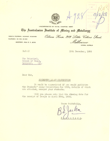
Letter - Correspondence, Miss B.E. Jacka, Secretary of the Australasian Institute of Mining and Metallurgy, Correspondence on Australasian Institute of Mining and Metallurgy Letterhead, 1958, 15/12/1958
The Australasian Institute of Mining and Metallurgy (The AusIMM) was founded in 1893 and provides services to professionals engaged in all facets of the global minerals sector. With a focus on providing leadership and opportunities to minerals industry professionals, the AusIMM delivers an ongoing program of professional development services to ensure our members are supported throughout their careers, enabling them to provide high-quality professional input to industry and the community. (http://www.ausimm.com.au/content/default.aspx?ID=94, accessed 09/09/2015)Typed correspondence, on the Australasian Institute of Mining and Metallurgy letterhead, relating to a students' essay competition. The letter is signed by the institute Secretary B.E. Jacka.australasian institute of mining and metallurgy, ausimm, b.e. jacka -
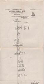
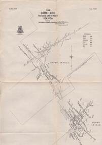
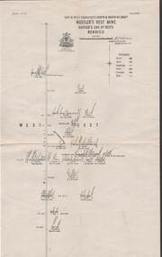
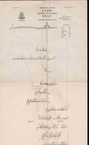
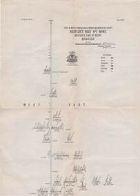
 Bendigo Historical Society Inc.
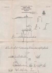
Map - STRUGNELL COLLECTION: HUSTLER'S LINE OF REEFS, BENDIGO, September 1913
Map, Hustler's Line of Reefs, Comet Mine, Transverse Section, Plate No.XXV (25). Bulletin No 33 Signed H.A.Whitelaw. Drawing shows the vertical shaft descending to over 1692 feet and appears to show samples of connecting horizontal shafts with their respective mineral contentsUnderground Survey Office, Bendigo.map, bendigo, comet mine -
Clunes Museum
Newspaper - NEWSPAPER CUTTING, AUSTRALIAN MINERALOGIST
.1 EXTRACT OF A PUBLICATION REPORTING ON THE WORKS OF THE PORT PHILLIP AND COLONIAL GOLD MINING COMPANY p.293 (Publication unknown) .2 EXTRACT FROM A JOURNAL RELATING TO THE MINERALS OF THE CLUNES GOLDFIELD p.47 Australian Mineralogist, volume 3, April-June, 1988local history, document, mining -
 Bendigo Historical Society Inc.
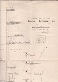
Map - STRUGNELL COLLECTION: UNDERGROUND SURVEY OF MINES, BENDIGO, 29-4-01
Map, Underground Survey of Mines, Bendigo.Eureka Extended Co., New Chum Line. Signed H.A.Whitelaw 29.4.01 Drawing shows mine shaft from 1871 feet to over 3030 feet deep and appears to show samples of connecting horizontal shafts with their respective mineral contents.A>S>Whitelawmap, bendigo, eureka extended co. -
 Bendigo Historical Society Inc.
Map - STRUGNELL COLLECTION: HUSTLER'S LINE OF REEFS, September 1913
Map, Hustler's Line of Reefs, Hustler's Consols Mine, Transverse Section, Bendigo.Plate no. XXX111 (33).Bulletin No 33 Signed H.A.Whitelaw. Drawing shows the vertical shaft descending to over 1326 feet and appears to show samples of connecting horizontal shafts with their respective mineral contentsUnderground Survey Office, Bendigo.map, bendigo, hustler's consols mine -
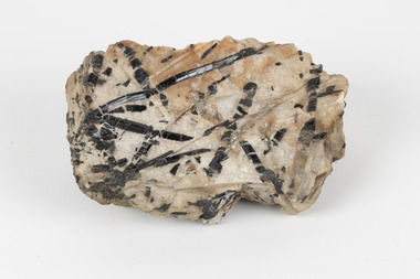 The Beechworth Burke Museum
Geological specimen - Tourmaline in Quartz, Unknown
... minerals ...Tourmaline specimens are members of a crystalline silicate mineral group based on boron but influenced by elements including aluminium, iron, magnesium, sodium, lithium, or potassium. Specimens present a wide variety of colours and forms according to the specific mix of these elements. Tourmalines are semi-precious gemstones with many applications, including commercial jewellery production. The word 'tourmaline' derives from the Sinhalese term for the carnelian or red-shaded specimens, "tōramalli". This specimen has been classified by geologists as 'Black Schoalou/Tourmaline in quartz'. Schoalou may equate to a common black-hued type of Tourmaline associated since around 1400 with mines in Saxony, Germany near a village called Schorl (today's Zchorlau). If this specimen is part of the 'Schorl' species of tourmaline it is a member of the most common group of Tourmalines, a divalent sodium ion influenced group accounting for 95% of specimens. On assessment, it was noted that the crossed lines (XIs) of this tourmaline have been fractured and rehealed by the quartz matrix in which the tourmaline rests. This item is significant as an example of its type of gemstone and the geological processes leading to its formation. A solid medium-sized piece of Black Schoalou/Tourmaline in a cream and peach coloured quartz matrix. Existing label: Black Schoalou / Tourmaline in / quartz. / Tourmalines XIs have / been fractured and / rehealed with / quartz / C. Willman / 15/4/21 /geological specimen, geology, geology collection, burke museum, beechworth, indigo shire, north-east victoria, tourmaline, quartz, boron, crystals, minerals, gemstones, semi-precious, black schoalou, zchorlau, schorl -
 Bendigo Historical Society Inc.
Map - STRUGNELL COLLECTION: HUSTLER'S LINE OF REEFS, September 1913
Map, Hustler's Line of Reefs, Hustler's Reef Mine, Transverse Section, Bendigo. Plate No. XV111 (18).Bulletin No 33 Signed, H.A.Whitelaw. Drawing shows the vertical shaft descending to over 2195 feet and appears to show samples of connecting horizontal shafts with their respective mineral contentsUnderground Survey Office, Bendigo.map, bendigo, hustler's reef mine -
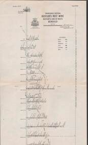
 Bendigo Historical Society Inc.
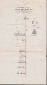
Map - STRUGNELL COLLECTION: HUSTLER'S LINE OF REEFS, September 1913
Map, Hustler's Line of Reefs, Hustler's Reef No.1 Mine Bendigo, Transverse Section.Plate No. XX1 (21).Bulletin No 33 Signed H.A.Whitelaw. Drawing shows the vertical shaft descending to over 1428 feet and appears to show samples of connecting horizontal shafts with their respective mineral contentsUnderground Survey Office, Bendigo.map, bendigo, hustler's reef no.1 mine -
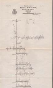
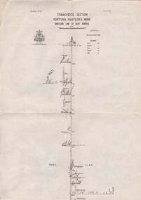
 Bendigo Historical Society Inc.
Map - STRUGNELL COLLECTION: HUSTLER'S LINE OF REEFS, BENDIGO, September 1913
Map, Hustler's Line of Reefs, Comet Mine, Bendigo Plan.Plate No.XX1V (24). Map, Bulletin No 33 Signed H.A.Whitelaw Underground survey Office Bendigo September 1913 Drawing shows upper and lower levels and appears to show samples of connecting horizontal shafts with their respective mineral contentsUnderground Survey Office, Bendigo.map, bendigo, comet mine -
 Bendigo Historical Society Inc.
Map - STRUGNELL COLLECTION: HUSTLER'S LINE OF REEFS, BENDIGO, September 1913
Map, Hustler's Line of Reefs, Fortuna Hustler's Mine, Bendigo, Transverse Section. Plate Mo.111(3).Bulletin No 33 Signed H.A.Whitelaw. Drawing shows the vertical shaft descending to over 2228 feet and appears to show samples of connecting horizontal shafts with their respective mineral contentsUnderground Survey Office, Bendigo.map, bendigo, fortuna hustler's mine -
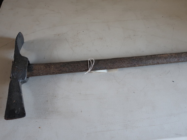 Kiewa Valley Historical Society
Miners Pick - long
Miners' picks were commonly used in the nineteenth and early twentieth century for extracting gold from underground mine tunnels.Found in the Harrietville area. Similar to those used in the nearby Kiewa Valley where prospecting for gold was also an occupation.Formerly KV 071. Handmade - of steel with a wooden handle. It was used to break up rock and ore, making it easier to extract valuable minerals. The pointed end of the pickaxe was used to chip away at rock, while the flat end was used to strike the rock for breaking it apart. This one has a long handle.gold mining, miners' pick -
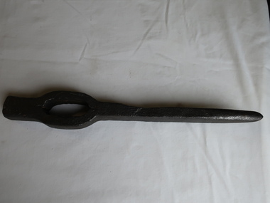 Kiewa Valley Historical Society
Miners' Pick Axe Head
Miners used pickaxes to break up rock and ore, making it easier to extract valuable minerals. The pointed end of the pickaxe was used to chip away at rock. The flat end was used to strike the rock for breaking it apart.Used in the Kiewa Valley by miners searching for gold.Cast steel 14 inches long with a sharp pointed end and a small flat end. There is a space for the handle which is missing and may have been made from wood.mining, miners' pick axe -
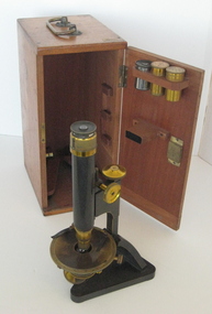 Federation University Historical Collection
Scientific Instrument, Petrographic Microscope
This microscope is thought to be one of the earliest 'mineral microscopes' obtained by the Ballarat School of Mines. See reference in SMB Calendar 1896, p47, also Ballarat SChool of Mines Calendar 1908-9, p35 - "petrological microscope".Black-finished brass microscope and brass stage. Includes adjustment knobs, lens mounts,three objective lenses and two eyepiece lenses of same rating. The microscope is boxed in a timber storage case, hinged at the front with a brass handle on top. Model: London, Ser.no. 26791Engraved on rear of base frame "R. & J. BECK Ltd LONDON 26791"petrographic microscope, microscope, petrology, ballarat school of mines, school of mines ballarat, mineral microscope, laboratory, r. & j. beck ltd -
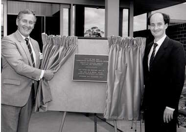 Box Hill Historical Society
Photograph - Consolidated Electricity Services Centre
Unveiling of a plaque at the opening of the Consolidated Electricity Services Centre, by the Hon. D R White, Minister for Minerals and Energy on Saturday 24th November 1984. On the left is John Wilkins, Chief Electrical Engineer with the Box Hill Electric Supply.Black and white photographbox hill electric supply, electricity, opening ceremonies, wilkins> john, white> david -
 Bendigo Historical Society Inc.
Map - STRUGNELL COLLECTION: HUSTLER'S LINE OF REEFS, BENDIGO, September 1913
Map, Hustler's Line of Reefs, Hustler's Reef Mine, East & West Cross-Cuts, North & South of Shaft. Plate No. X1X (19).Bulletin No 33 Signed H.A.Whitelaw. Drawing shows the vertical shaft descending to over 1296 feet and appears to show samples of connecting horizontal shafts with their respective mineral contentsUnderground Survey Office, Bendigo.map, bendigo, hustler's reef mine -
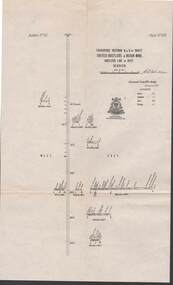 Bendigo Historical Society Inc.
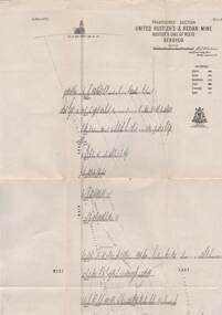
Map - STRUGNELL COLLECTION: UNITED HUSTLER'S & REDAN MINE, September 1913
Map, Transverse Sections N. & S. Of shaft, United Hustler's & Redan Mine, Hustler's Line of Reef, Bendigo. Plate No. XXX (30).Bulletin No 33 Signed H.A.Whitelaw. Drawing shows the vertical shaft descending to over 976 feet and appears to show samples of connecting horizontal shafts with their respective mineral contentsUnderground Survey Office, Bendigo.map, bendigo, hustler's & redan mine -
 Bendigo Historical Society Inc.
Map - STRUGNELL COLLECTION: HUSTLER'S LINE OF REEFS K.K.MINE, September 1913
Map, Hustler's Line of Reefs, K.K.Mine,Transverse section.Plate No.XXX11(32).Geological Survey of Victoria.Bulletin 33.Signed H.A.Whitelaw. Drawing shows the vertical shaft descending to over 1932 feet and appears to show samples of connecting horizontal shafts with their respective mineral contents and dotted lines appear to show connecting reefs .Underground Survey Office, Bendigo,map, bendigo, k.k.mine -
 Federation University Historical Collection
Letter - Correspondence, Miss B.E. Jacka, Secretary of the Australasian Institute of Mining and Metallurgy et al, Correspondence on Letterhead from the Australasian Institute of Mining and Metallurgy, 1968, 1968
The Australasian Institute of Mining and Metallurgy (The AusIMM) was founded in 1893 and provides services to professionals engaged in all facets of the global minerals sector. With a focus on providing leadership and opportunities to minerals industry professionals, the AusIMM delivers an ongoing program of professional development services to ensure our members are supported throughout their careers, enabling them to provide high-quality professional input to industry and the community. in 2015 The AusIMM represents 14 000 members drawn from all sections of the industry and supported by a network of branches and societies in Australasia and internationally. (http://www.ausimm.com.au/content/default.aspx?ID=94, accessed 09 September 2015).1) Typed letter on letterhead from the Australasian Institute of Mining and Metallurgy to to the Ballarat School of Mines from B.E. Jacka, Secretary. The letter relates to the application for admission to the Institute from Robert Frederic Murrell who received a Diploma at the Ballarat School of Mines in 1962. .2) Carbon copy of a typed letter from Harold J. Trudinger, Principal of the Ballarat School of Mines. ausimm, australasian institute of mining and metallurgy, b.e. jacka, harold trudinger, robert f. murrell, ballarat school of mines, mining -
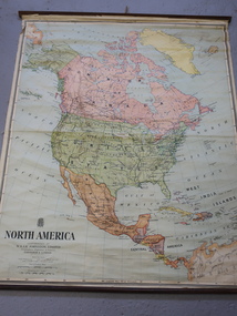 Kiewa Valley Historical Society
Maps - Educational x 10 and Kiewa Scheme x1
Maps were used to teach children geography, the explorers, the minerals, the world etc. The school bought and stored the maps so that they were available for use. This predated electronic devices. The KHE Works map was hand drawn showing lots of detail.These maps were used by the Bogong Primary School. The Kiewa Hydro Electric Works was built by the SECV and produced hydro power. This map may have been used by pupils as well as workers on the Works. Large coloured maps on canvas, with a wooden beam along the top and bottom. Each one has a cord attached to the top so that the map may be hung up on a wall. Some are made by Chas. H. Scally & Co., Baronia Ave., Wollstonecraft, N.S.W. The Kiewa Hydro Electric Works map is pinkish and shows Rocky Valley Dam, Lake Guy and Mt Beauty pondage in dark blue.maps, educational maps, geography, primary school, kiewa hydro electric works -
 Bendigo Historical Society Inc.
Map - STRUGNELL COLLECTION: HUSTLER'S LINE OF REEF'S. HUSTLER'S REEF NO.1 MINE, September 1913
Map, Hustler's Line of Reefs, Hustler's Reef No. 1, Bendigo, East & West Cross-cuts, North & South of Shaft, Plate No.XX11 (22). Bulletin No 33 Signed H.A.Whitelaw. Drawing shows the vertical shaft descending to over 1229 feet and appears to show samples of connecting horizontal shafts with their respective mineral contentsUnderground Survey Office, Bendigo.map, bendigo, hustler's reef no.1 mine -
 Bendigo Historical Society Inc.
Map - STRUGNELL COLLECTION: HUSTLER'S LINE OF REEFS, BENDIGO, September 1913
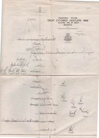
Map, Hustler's Line of Reefs, Great Extended Hustler's Mine, Bendigo, Transverse Section. Plate No. X11 (12). Bulletin No 33 Signed H.A.Whitelaw Underground survey Office Bendigo September 1913 Drawing shows mine shaft to over 3454 feet deep and appears to show samples of connecting horizontal shafts with their respective mineral contentsUnderground Survey Office, Bendigo.map, bendigo, great extended hustler's mine -
 Bendigo Historical Society Inc.
Map - STRUGNELL COLLECTION: HUSTLER'S LINE OF REEFS, BENDIGO, September 1913
Map, Hustler's Line of Reef, Hustler's Royal Reserve No. 2, Park Shaft, Bendigo, Plate No. 1X (9). Bulletin No 33 Signed H.A.Whitelaw Underground survey Office Bendigo September 1913 Drawing shows mine shaft to over 1099 feet deep and appears to show samples of connecting horizontal shafts with their respective mineral contentsUnderground Survey Office, Bendigo.map, bendigo, hustler's royal reserve no. 2 mine* -
 Bendigo Historical Society Inc.
Map - STRUGNELL COLLECTION: UNITED HUSTLER'S & REDAN MINE, September 1913
Map, United Hustler's & Redan Mine, Transverse Section, Hustler's Line of Reefs, Bendigo. Plate No. XX1X (29).Bulletin No 33 Signed H.A.Whitelaw. Drawing shows the vertical shaft descending to over 1805 feet and appears to show samples of connecting horizontal shafts with their respective mineral contents. One level shows respective water levels .Underground Survey Officemap, bendigo, hustler's & redan mine