Showing 11365 items
matching on the map
-
 Tatura Irrigation & Wartime Camps Museum
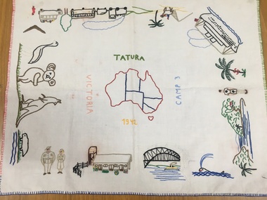
Tray Cloth, Exodus of Templers to Australia, 1942
Calico brought from Palestine and embroidered in camp 3 by 14 year old Anne Marie Treftz (now Mrs Anne Marie Reugg)Calico tray cloth, embroidered in many colours, around the 4 edges with scenes depicting the progressive exodus of the Templers from Palestine to Australia by bus, train, camel, and super liner the Queen Elizabeth. Sydney Harbour Bridge, Army personnel and unique Australian fauna. In the centre is an embroidered map of Australia. Around the map are the words: Tatura Camp 3 1942 VictoriaAround the Map of Australia- words Tatura- Camp 3- 1942- Victoriatatura, tray cloth, treftz, anne marie, palestine, kazenwadel, kurt, camp 3, reugg, templers, handcrafts, embroidery, manchester, table, linen -
 Greensborough Historical Society
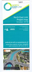
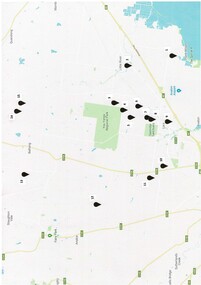
Leaflet, North East Link Authority, North East Link: project map October 2018, 2018_10
North East Link Authority was set up to lead development of this project. This map shows the proposed route with major intersections/interchanges. Map, colour text and images.north east link -
 Kew Historical Society Inc
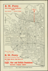
Map - Map of Kew and Hawthorn Districts
Map of Kew, East Kew and Hawthorn produced for a Kew Real Estate Agent, RW Perry. The map is undated.Two-colour map of Kew and Hawthorn Districts produced for by R.L. Jarrett for RW Perry, Real Estate & Insurance Agent. The map has unusual features such as a planned railway link from Kew Station to the former Outer Circle Railway. RW Perry / Real Estate & Insurance Agent, 602 High Street, East Kewmaps - kew (vic), maps - hawthorn (vic), r.w. perry, real estate agents -- kew (vic.) -
 Whitehorse Historical Society Inc.
Map - Parish Map, Parish of Nunawading, 1892
A map copied from 'Directory maps - parishes and counties' dated 26 Nov 1892. Compiled and lithographed by G.S. Bonney. The map includes roads, railway, stations, names of property owners. It has a scale [ca. 1:31,680] 40 chains to an 1 inch.A map copied from 'Directory maps - parishes and counties' dated 26 Nov 1892. Compiled and lithographed by G.S. Bonney. The map includes roads, railway, stations, names of property owners. It has a scale [ca. 1:31,680] 40 chains to an 1 inch.non-fictionA map copied from 'Directory maps - parishes and counties' dated 26 Nov 1892. Compiled and lithographed by G.S. Bonney. The map includes roads, railway, stations, names of property owners. It has a scale [ca. 1:31,680] 40 chains to an 1 inch.maps, parish of nunawading -
 Greensborough Historical Society
Map, Victoria. Department of Crown Lands and Survey, Keelbundoora; Counties of Bourke and Evelyn, 1950c
Map of the Victorian counties of Bourke and Evelyn showing parish boundaries and land ownership.Show the original landholders for this area.Map on light brown parchment, covered in plastic."L.5305" and "3462" -
 Peterborough History Group
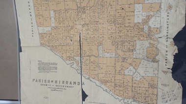
Map - Map of the Parish of Nirranda, Parish of Nirranda
Map of the Parish including roads, names of landowners, location of schools etc in 1939A3 size map of the Parish of Nirranda in 1939nirranda, maps, parish map -
 Whitehorse Historical Society Inc.
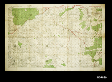
Map - WW1 map of France, WW1 map of France - regional. Field Survey Map of Enemy Rear Organisation, 08/10/1918
Enemy Rear Organisation map Scale 1 : 40,000Field Survey Map of Enemy Rear Organisationnon-fictionEnemy Rear Organisation map Scale 1 : 40,000maps, world war 1914 - 1918 -
 Bendigo Military Museum
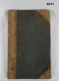
Journal - Army Survey Regiment Map Store Distribution Register 1978-1986, 04.07.1978
This is a record of the maps that were despatched from the Army Survey Regiment Map Store 1978 - 1986Leather Bound "Minute Book", lined paper, hand written records of ASR Map distribution. royal australian survey corps, rasvy, fortuna, army survey regiment, army svy regt, asr -
 Clunes Museum
Pamphlet, BUSINESS & TOURISM, BURIED RIVERS OF GOLD, 2021
MAP OF DEEP LEAD MINES, CRESWICK. WALKING TOURCOLOURED PAMPHLET FOLDED TO DL SIZE. INCLUDES MAP AND INFORMATION FOR SELF GUIDED TOUR. MAP OF THE DEEP LEAD MINES, CRESWICK, AND NOTES FOR YOUR SELF-GUIDED TOUR.gold mining, creswick -
 Tatura Irrigation & Wartime Camps Museum
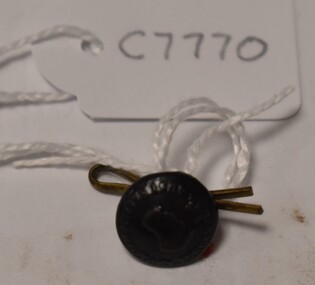
Button, Stokes and Sons
Issued to Sister Kathleen Heaphy of Australian Army Nursing service. Sister Heaphy was attached, for part of her service, to 28 Camp Hospital Internment camp 1.Small round button with a metal shank. Crown and map of Australia and wording around the circumference. A split pin is through the shanks. Red cotton around the shank.Australian Military Forces A crown and map of Australia Stokes and Sons Melbaustralian army nursing service, sister kathleen heaphy, 28 camp hospital internment camp 1, brass buttons -
 Marysville & District Historical Society
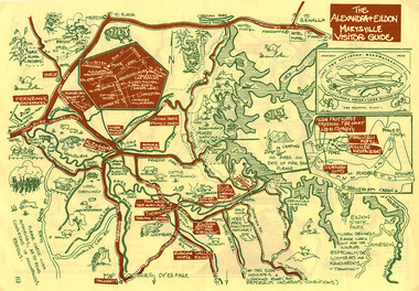
Map (Item) - Tourist map, The Alexandra and Eildon Standard, THE ALEXANDRA & EILDON MARYSVILLE VISITOR GUIDE, 1997
A tourist map for the Alexandra, Eildon and Marysville region that was produced by the Alexandra and Eildon Standard newspaper. This tourist map was produced in 1997.A tourist map for the Alexandra, Eildon and Marysville region that was produced by the Alexandra and Eildon Standard newspaper.c 1997/ PUBLISHED BY/ THE ALEXANDRA/ AND EILDON/ STANDARD./ GRAPHICS/ BY THE T.T.S./ EILDON.alexandra, eildon, marysville, victoria, australia, tourist map, alexandra & eildon standard -
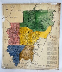 Greensborough Historical Society
Poster - Map, City of Heidelberg, 1965c
Map of the City of Heidelberg showing municipal boundaries and Wards are coloured. Scale 20 chains to 1 inch.An example of hard copy plans from the 1960s. Mainly from the Shire of Diamond Valley era (1964-1994).Colour map, pasted on card and laminated.Stamped and handwritten Council permissions, dates and other details. city of heidelberg, heidelberg - maps, local government -
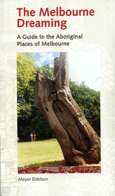 Victorian Aboriginal Corporation for Languages
Book, Meyer Eidelson, The Melbourne dreaming : a guide to the Aboriginal places of Melbourne, 1997
This guide shows Melbourne?s Aboriginal places so that people using it can gain easy access to and a greater knowledge of them. Important historical events occurred at some of them. Others are Archaeological sites where there are still physical remains of Aboriginal activity before settlement. Locations have been mapped and Melways references and maps are included.maps, b&w illustrations, colour illustrations, colour photographs, word listswoi wurrung, wurundjeri, boon wurrung, kulin, yarra yarra, yarra river, werribee river, bunjil, waa, moieties, maribyrnong, sacred sites -
 Warrnambool and District Historical Society Inc.
Map - Soldier Settlement Map, Soldier Settlement Commission, Tarrone Estate Alex Boyd, 1940s
This is a map of the Tarrone Soldier Settlement land divisions probably produced by the Soldier Settlement Commission. The map is incomplete with lots 48,49 and 50 missing. The Soldier Settlement Commission purchased 23,373 acres of Tarrone Station from the Boyd brothers in 1947 and the sub divided lots were occupied by soldier settlers commencing in 1949. Tarrone Station was established in 1840 by Doctors Kilgour and Bernard and the Boyd brothers secured the free hold in the 1890s and retained it until 1947. The map hung for many years in the Warrong school near Hawkesdale.This map is of considerable interest as an original item from the establishment of the Tarrone Soldier Settlement..The map is made of brown cloth and creased. The edges are tattered and there is a piece missing at the top. It is a map of allotments, hand drawn and with faded colours in red, blue and yellow. The names of localities and land holders are hand written in ink and chalk. The map is contained within two pieces of wood at the bottom and the top. There are two screws and a cord to hang on a wall. A scale of measurement is shown under the map. tarrone soldiers settlement, boyd brothers tarrone -
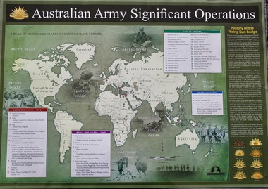 Lara RSL Sub Branch
Map - Areas in Which Australian Soldiers Have Served - World War 1 and World War 2 and Other Theatres (2 Off), Australian Army Significant Operations Map. (2 Off)
This map shows the areas in which Australian soldiers have served.Map of World showing Australian Armed Forces Theatre of Operations (Map)Rectangular in shape with a glossy front. (2 Off)Australian Army Significant Operationsaustralian army significant operations -
 Vision Australia
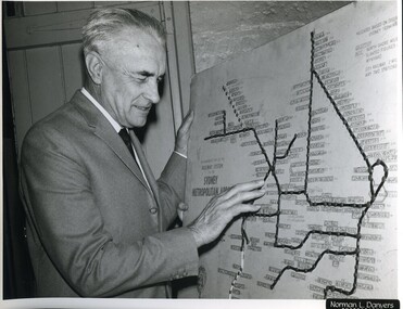
Photograph - Image, Ron Bruce reading Sydney Train map, 1971?
Ron Bruce reading a Braille map of Sydney's railway network.B/W photograph of man reading braille map1/71016 M&O -historicalroyal blind society of nsw, ron bruce, maps -
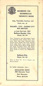 Melbourne Tram Museum
Map - Map, Timetable, Sections, and Fares, etc., of BULLEEN - CITY - GARDEN CITY BUS SERVICES
Map of the MMTB Bulleen - City - Garden City bus routes. Map, timetable & fares for Bulleen to City bus routemmtb, buses, doncaster, city -
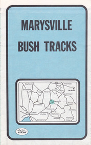 Marysville & District Historical Society
Map (Item) - Bush tracks map, John Siseman et al, MARYSVILLE BUSH TRACKS, 1987
A fold out map of the bush tracks in and around Marysville with information regarding each track. This map was published by Pindari Publications and distributed by Algona Publications. The track notes were compiled by John Siseman in 1987. The map was drawn by Glenn van der Knijff.A fold out map of the bush tracks in and around Marysville with information regarding each track.marysville, victoria, australia, map, bush tracks, pindari publications, algona publications, john siseman, gleen van der knijff, lady talbot forest drive, beauty spot walk, michaeldene track, steavenson falls, tree fern gully walk, trestle track, phantom falls, marysville town walk, marysville lookouts round walk, keppel falls, the beeches round walk, cumberland scenic reserve, cambarville, lake mountain, lake mountain walking track -
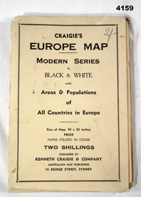 Bendigo Military Museum
Map - MAP of EUROPE, Craigie"s Europe Map, 1939
The map features the areas and populations of all European countries as per 1939. Part of the collection re Frederick Gardner Davey DFC No 410533 RAAF. Refer Cat No 3536P for his service details.Folded map in black and white. Coloured British and German flags are pinned to countries on the map.On the front cover in pencil, “2/-“. (2 schillings)maps, europe -
 Lara RSL Sub Branch
Work on paper - Map of Lara and surrounds, Soldiers Settlement Lara District WWI
Soldier Settlement Lara District After World War 1Map of Lara with soldiers settlements marked 1-15 Legend of the soldiers settlements Conditional Purchase LeaseMap is numbered 1-15 Legend lists names and allotments Lease shows costings of such leasessoldier settlement lara district after world war 1 -
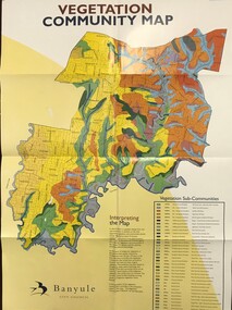 Greensborough Historical Society
Maps, Vegetation Community Map, 2000c
Map and table of indigenous vegetation 'communities' in Banyule. Map & table, printed in colour both sides, folded to A4banyule city council, flora, vegetation, gum trees -
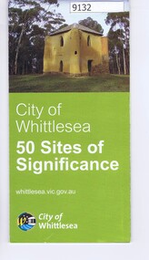 Greensborough Historical Society
Pamphlet - Map, City of Whittlesea, City of Whittlesea, 50 Sites of Significance
Pamphlet of historical places in Whittlesea with map and imagesColour pamphlet with text, fold out map and coloured imageswhittlesea, historic sites whittlesea -
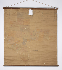
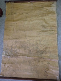 Greensborough Historical Society
Map, Map of Greensborough - Jessop's Real Estate, 1930c
This map of Greensborough hung in the office of Cec Jessop's Real Estate office corner Main and Grimshaw Street. Includes a word document listing street name changes from the original map to today, according to Norm Colvin.This map was saved from the building when the business closed.Canvas roll-up map with timber rails top and bottom.greensborough - maps, cecil jessop, greensborough street names -
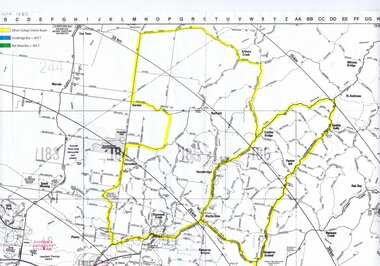
![Map, Plan showing proposed deviation of the road through McKenzie's Flat to Bacchus Marsh. [Undated]](/media/collectors/5e461d8021ea67224c82f2a1/items/677d22f37f2053f3e5d500dc/item-media/677d25247f2053f3e5d50950/item-fit-380x285.jpg) Bacchus Marsh & District Historical Society
Bacchus Marsh & District Historical SocietyMap, Plan showing proposed deviation of the road through McKenzie's Flat to Bacchus Marsh. [Undated]
The date of this map or plan is uncertain. McKenzie's Flat is a bushland picnic area on the Lerderderg River in the Lerderderg State Park close to Bacchus Marsh. The proposed road deviation shown on this map is very close to a sharp bend in the Lerderderg River which shows an island in the centre of that bend. The name of a landholder, J.B. Perry is shown on the map close to the area of the road deviation.The land shown is identified as within the Parish of Merrimu.Single page map showing a proposed deviation of the road from McKenzie's Flat to Bacchus Marsh. Scale: 5 chains to 1 inch. Part of a set of maps which are pasted into a bound volume containing 76 maps or plans in total. High resolution digital image stored on BMDHS computer network. mckenzies flat bacchus marsh, bacchus marsh roads and streets -
 Kiewa Valley Historical Society
Maps - Educational x 10 and Kiewa Scheme x1
Maps were used to teach children geography, the explorers, the minerals, the world etc. The school bought and stored the maps so that they were available for use. This predated electronic devices. The KHE Works map was hand drawn showing lots of detail.These maps were used by the Bogong Primary School. The Kiewa Hydro Electric Works was built by the SECV and produced hydro power. This map may have been used by pupils as well as workers on the Works. Large coloured maps on canvas, with a wooden beam along the top and bottom. Each one has a cord attached to the top so that the map may be hung up on a wall. Some are made by Chas. H. Scally & Co., Baronia Ave., Wollstonecraft, N.S.W. The Kiewa Hydro Electric Works map is pinkish and shows Rocky Valley Dam, Lake Guy and Mt Beauty pondage in dark blue.maps, educational maps, geography, primary school, kiewa hydro electric works -
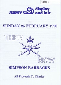 Greensborough Historical Society
Booklet, Simpson Barracks, Then and now: Army display and fair 1990, 25/02/1990
Display and fair programme describing events with map of locations, held at Simpson Army Barracks 25/02/1990.8 page booklet with programme and map.Paperaustralian army, watsonia army barracks, simpson army barracks -
 Peterborough History Group
Map - Map of the town, Government Printer, Township of Peterborough
Map donated by Barry Jenkins and assume that updated names were written on the map by him. Good information pertaining to the history of each allotment. Significant as it shows the names of the owners of each allotment in 1931 and handwritten notes of more recent owners.27/6/1931 paper map of the township of Peterborough including names of the landowners at that time.Handwritten landowner names over the original printed names.peterborough, old maps, maps -
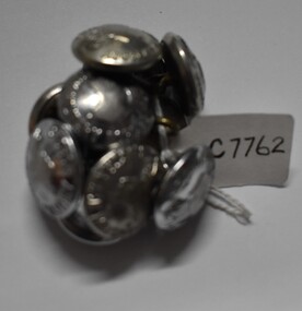
Tatura Irrigation & Wartime Camps Museum
Buttons
Issued to Sister Kathleen Heaphy of Australian Army Nursing service. Sister Heaphy was attached, for part of her service, to 28 Camp Hospital Internment camp 1.4 round identical brass buttons with a metal shank crown and map of Australia and wording around the circumference. 2 of the buttons have split pins through the shank.Australian Military Forces and a crown and map of Australia. Stokes and Sons Melbourneaustralian army nursing service, sister kathleen heaphy, 28 camp hospital internment camp 1, brass buttons -
 Tatura Irrigation & Wartime Camps Museum
Buttons, 1049's
Issued to Sister Kathleen Heaphy of Australian Army Nursing service. Sister Heaphy was attached, for part of her service, to 28 Camp Hospital Internment camp 1.10 identical round silver metal buttons with a metal shank crown and map of Australia and wording around the circumference. 2 have split pins through the shank.Australian Military Forces and a crown and map of Australia. Stokes and Sons Melbourneaustralian army nursing service, 28 camp hospital internment camp 1, silver metal buttons -
 Greensborough Historical Society
Map, Greensborough c 1980s, 1980s
Map of Greensborough and surrounds showing bus routes servicing Eltham College.Map of Greensborough and surrounds, black print with colour markings."Bundoora Retirement Village" marked in red pen at E20greensborough - maps, eltham college, bus routes, public transport