Showing 294 items
matching original settlers
-
 Victorian Aboriginal Corporation for Languages
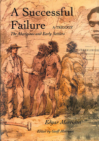
Book, Edgar Morrison, A successful failure, a trilogy : the Aborigines and early settlers, 2002
Tells of the Aboriginal Protectorate System in Colonial Victoria during the period 1838 to 1852. The system was designed to be a buffer between the original inhabitants and the influx of white squatters. That the system failed is of little wonder. This story traces the times of Edward Stone Parker, Assistant Aboriginal Protector in the Loddon region of Victoria.maps, b&w photograph, colour photographs -
 Victorian Aboriginal Corporation for Languages
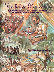
Book, Lindsey Arkley, The hated protector : the story of Charles Wightman Sievwright, protector of Aborigines 1839-42, 2000
"The hated Protector" tells for the first time the real story behind the extraordinary experiences of Charles Sievwright, Assistant Aboriginal Protector from 1839-42 in what was then part of the British colony of New South Wales, but is now the Western District of the Australian state of Victoria. Sievwright, an Edinburgh-born former British army officer, lived in the bush with his young family as he tried to save the Aborigines of the District from extinction. In doing so, he would isolate himself from the rest of his fellow whites. The hated Protector tells of this process. The book should appeal to anyone interested in British colonial and Australian history, particularly in the years of first contact between British settlers and the Aborigines. More broadly, it should also appeal to anyone interested a story of one man's battle against overwhelming odds, where the price of failure was numerous deaths. It is a story of hatred, prejudice, courage, determination, and hope. In telling Sievwright's story, Lindsey Arkley draws largely on original archival material, including official reports, journals and letters, found in Melbourne, Sydney, Hobart, Edinburgh and London. Most has never before been published. The archival material is supplemented by contemporary newspaper accounts, and some oral history. Full notes are given to all sources, and the book is indexed and lavishly illustrated with drawings by Joan Bognuda, as well as about 80 paintings and samples of documents. Contents: 1. In the bush 2. "Equal and indiscriminate justice" 3. "A few doses of lead" 4. "A curse to the land" 5. "The most unpopular man" 6. Retaliation 7. A hostage debate 8. Hallucinations 9. A mass escape 10. Possessors of the soil 11. Move to Keilambete 12. Bureaucratic 13. "A hideous pandemonium" 14. Divine visitations 15. Pay backs 16. Explanations 17. A squatter on trial 18. Claptrap and deceit 19. The black cap - 20. To Mt Rouse 21. "The impending evil" 22. In the balance 23. An arrest at Mt Rouse 24. A fair moral name 25. Roger's trial 16. Intensified evidence 27. A declaration of war 28. Mr Cold Morning 29. Holding ranks 30. To rags 31. Fightback 32. Return to London 33. The inquiry 34. Judgement 35. And what remains.maps, document reproductions, b&w photographs, colour photographs, b&w illustrationscharles wightman sievwright, racial policies, british colonial history, race relations, victorian history -
 Clunes Museum
Photograph
MRS. WILLIAMSON WAS THE ORIGINATOR AND ORGNISER OF THE MEMORIAL PANELS OF W.W.1 SOLDIERS PHOTOGRAPHS WHICH FOR MANY YEARS HUNG IN THE CLUNES TOWN HALL. NOW ON DISPLAY IN MUSEUM.PHOTOGRAPH, BLACK AND WHITE [ORIGINAL] IN ORIGINAL WOODEN MOUNT OF MRS. G. WILLIAMS, MRS WILLIAMS ORGANISED THE MILITARY PHOTOS. THERE WERE ORIGINALLY FOUR PANELS OF PHOTOS, BUT TWO PANELS WERE DAMAGED WHILE IN THE TOWN HALL AND THE REMAINING TWO PANELS ARE LOCATED IN THE HOLLY BARKELL GALLERY.J.HALLAM WEBB & WEBB. PERTH W.A.photographs, military, early settlers, mrs. g. williams -
Koorie Heritage Trust
Document - Printed Sheets, Batey, Isaac, The Aboriginals - transcript of the handwritten memoirs of Isaac Batey
This memoir contains observations of the Aboriginal people in the Sunbury area mainly. From 1844 onwards this young boy has recounted memories of his life, this section deals with Aboriginals. Although the language and observations may offend some people they are also a reflection of the attitudes of his times, and give an indication of the settlers' reactions to the inhabitants of a new land. Recorded in 1909.17 P.;This memoir contains observations of the Aboriginal people in the Sunbury area mainly. From 1844 onwards this young boy has recounted memories of his life, this section deals with Aboriginals. Although the language and observations may offend some people they are also a reflection of the attitudes of his times, and give an indication of the settlers' reactions to the inhabitants of a new land. Recorded in 1909.batey, isaac b. 1838., sunbury - red stone hill - ?boriginals, history., aboriginals - woiworong - hunting; possum skin rug making; baskets; cooking ovens; death-customs; myrnong. -
 Whitehorse Historical Society Inc.
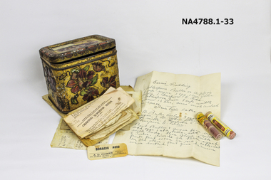
Container - Tin, 1897
... grandmother. William Course was an original settler in 6the area ...Tin belonged to Martha Edwards (nee Course) who died in 1957. She was married in 1897. Martha was the donor's grandmother.William Course was an original settler in 6the area arriving in the area in1859. Martha was the 11th of 12 children. the boys of the family all worked at Geal Bros. potteries.A tin containing hand written recipes and two phials of junket tablets and Boracic acid label. Tin has a yellow background with flowers in purple and green leaves around all four sides.The top has a frame of flowers with a scene in the middle of a large building with trees around it. Many handwritten recipes inside with two junket tablet phials and a boracic acid label. A total of 33 items including the tin.Martha Edwards Recipe box 1950s. notice spicy smelldomestic items, cooking -
 Ballarat Heritage Services
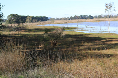
Photograph - Digital photograph, Dorothy Wickham, Winter's Swamp, Ballarat, January to April 2014
Study of Winter's Swamp commissioned by BEN and completed by BHS. The swamp was named after one of the first European settlers in the district. Winter Swamp LAT -37 32 LONG 143 47, Parish of Dowling Forest, County of Grenville Winter Swamp, on the southwest corner of Ballarat West Town Common, was not included in the original proclamation of the Common in 1861. However, being marshland, it was not considered suitable for grazing, so was added to the Common soon after 1861. Winter Swamp is a large wetland with native and exotic pasture significant for wildlife. John Winter (Jock) was born in Berwickshire, Scotland. He married Janet Margaret Irving the daughter of Robert Irving, advocate, Bonshaw, Dumfries, Scotland. Winter died in Ballarat in 1875 and was buried at the Ballaarat Old Cemetery. He took up the run Bonshaw from 1841; Leigh River Buninyong 1842-46; Junction, Delatite, March 1851 to September 1862; with sons: Carag Carag and Corop, April 1857 to September 1872; Colbinabbin and Stewart’s Plains, April 1857 to December 1872; St Germains February 1867 to March 1871. (The name became Winter-Irving in 1890). Mr John Winter, who died on August 22 at the age of 72, was a man of some note it the mining community of Ballarat. He was a self-made man, and one of our oldest colonists, it being over a quarter of a century age since he took up county about Ballarat and settled at Bonshaw. He died very rich. It is calculated that if he had retained an interest in all his runs, his income must have been not less than £10,000 or £50,000 a year. Some eight or ten years ago he sold his Bonshaw pre-emption to the Bonshaw Gold mining Company for £20,000, and a few years later the ground belonging now to Winter's Freehold Company brought him £50,000 more, the payment being made at the requisition of the deceased in sovereigns. In these relations Mr. Winter has been closely identified with the mining industry at Ballarat. The deceased was a native of Lauder, in Berwickshire, and landed in Victoria several years before the gold discovery.The principle task of this project was the delivery of a report outlining the history of European settlement in the Skipton and Cardigan/Ballarat districts as pertinent to the use of and impact on the natural environment of the two reserves Skipton Common and Winter Swamp. The report was delivered in digital form only. The report, upon completion, was presented to the Network’s Committee in order to discuss the project. The report identified and described the uses of Skipton Common and Winter Swamp, and their impacts. In particular, this report examined farming/grazing (official and informal), mining, vegetation removal (including the removal of woodlands for timber, grasslands for pasture improvement) & use of riparian areas for access to water and timber removal. Recording the more benign and environmentally friendly uses such as picnicking, community activities, nature walks and the roles of organisations such as Field Naturalists’ and Bird Observers’ clubs, school and scout/guide groups will be relevant in helping to depict overall community attitudes towards the reserves; e.g.: has the Common generally been viewed as little more than a grazing paddock and fire hazard; has Winter Swamp always been the unknown natural asset that seems to have been its lot for at least the past 40 years? In this regard, the more contemporary history of actions surrounding the use and management of the reserves is of particular interest, in view of the extant evidence at both reserves; e.g. the actions of the Shire of Ballarat in the 1980s in establishing Winter Swamp as something of a competitor to Lake Wendouree but with a more environmental bent (although almost none of the plants used are indigenous species, but that is part of the story); the trotting track constructed on Skipton Common in the 1960s following representations to Premier Henry Bolte and the cropping of the western section of the Common to raise funds for the town’s new swimming pool, the fertilizing of the land putting an end to the native grassland vegetation. There are obviously multiple sources of information to source in preparing the report, however sources that the contractor is specifically requested to consult are the Skipton Historical Society, the former Skipton Common managers (specifically Graeme Pett), the Cardigan Windermere Landcare Group and the Learmonth Historical Society (believed to hold many of the former Shire of Ballarat’s records pertaining to the Council’s role as the Committee of Management for both Winter Swamp and the Ballarat West Town Common – Winter Swamp was split between 2 separate Crown Land tenures). The contractor is also encouraged but not required to utilise community newsletters, such as the Skipton Community Newsletter, to publicise and seek information about the project. Skipton Historical Society (Mary Bradshaw) contacted on Thursday 12 June 2.30pm. Mary lived on a farm out of Skipton but is currently living in the township. She remembers walking along the creek of the Common especially in spring and autumn in bare feet and that it was a very pretty place. There were a few snakes around the waterway in summer. People put cows and a couple of horses on the commonage to graze. Graeme Pett has always lived close to the Common and would know a lot about it. Other possible contacts would be Nicole Petress, Secretary of the Progress Association, and the Corangamite Council, Camperdown. Digital images of Winter's Swampwinter's swamp, ballarat, john winter, ballarat environmental network, mullawullah -
 Whitehorse Historical Society Inc.
Photograph, Mrs Jane McDonnell
Black and white copy of a print of Mrs Jane Donnell (nee Cooney), wife of John Donnell, early settler and owner of the original Reserve Hotel in Mitcham. Donnell was known as McDonnelldonnell, jane, mcdonnell, cooney, john, reserve hotel, mitcham -
 Whitehorse Historical Society Inc.
Photograph, John McDonnell
Black and white photo of a print of John Donnell (died 27-4-1921) an early settler and owner of the original Reserve Hotel in Mitcham. Donnell was known as McDonnelldonnell, john, mcdonnell, reserve hotel, mitcham -
 Hume City Civic Collection
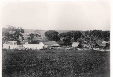
Photograph - Emu Bottom
The photograph was taken from the rear of the Emu Bottom Homestead and its outbuildings. George Evans, one of the earliest European settlers in Sunbury, built Emu Bottom homestead in the 1830s. The original building was made from Silurian sandstone cut from the surrounding hills. A black and white landscape photograph with a cream border of farm buildings.homesteads, emu bottom, george evans, settlers, jackson creek -
 Hume City Civic Collection
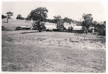
Photograph, Emu Bottom Homestead
... Evans, one of the district's earliest European settlers built... Evans, one of the district's earliest European settlers built ...The photograph was taken from the rear of the Emu Bottom Homestead and its outbuildings in front of the home paddock. George Evans, one of the district's earliest European settlers built the original homestead from Silurian sandstone removed from the surrounding hillsides in the 1830s.A black and white landscape photograph with a cream border of a farm house and outbuildingsemu bottom homestead, homesteads, george evans, jackson creek, sunbury -
 Mt Dandenong & District Historical Society Inc.
Photograph, Barber's Bridge on Olinda Creek
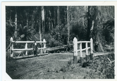
John Lundy-Clarke grew up in the Kalorama/Mt Dandenong area and later in life (1972-74) began to write a comprehensive history of the area working from an original settlement map in an effort to cover all areas. Barbers Bridge was named after George Barber, an early settler.Black and white photograph showing a man standing on a bridge over the Olinda Creek. 1910Handwritten n reverse: Barbers Bridge on Olinda Creek 1910. This was a ford crossed by the road after Isaac Jeeves selected allotment “C” “Jeeves Saddle” in 1871 and stopped travel through his property. The bridge has been built several times but at time of writing (1974) is replaced by a culvert consisting of two pipes two feet six inches wide. They are quite incapable of carrying the maximum flow of the creek and will be swept away.lundy-clarke, barber, barbers bridge, isaac jeeves, jeeves saddle, bridge, olinda creek -
 Mt Dandenong & District Historical Society Inc.
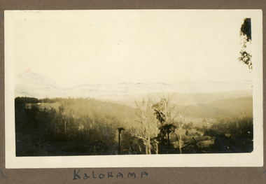
Photograph, View Over Roof of "Kalorama"
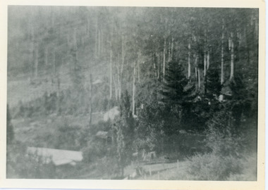
Taken in 1908, this photograph, though rather blurry, gives an indication of the location of the early settler properties in the valley in relation to one another. European trees have been planted at 'Kalorama' , the first home of Ellis Jeeves. John Lundy-Clarke grew up in the Kalorama/Mt Dandenong area and later in life (1972-74) began to write a comprehensive history of the area working from an original settlement map in an effort to cover all areas.Black and white photograph looking across hillside with large trees and rooftops visible. Handwritten description on reverse by John Lundy-Clarke.1908 View over roof of “Kalorama” towards the Falls. Paynter’s house on LOT 29 in low centre (now “Yosemite”). Pimms house on LOT 19 above Paynters and beyond scrub. Logan’s house faint above left of “Kalorama”. Dunbar’s LOT 20 beyond Pimm’s orchard. Gum trees on right were on Price’s LOT 19 now Tosari Rd area. It was one of these that figured in the episode of the runaway log in 1930. It leaped in one bound over Barbers Road at bottom of scrub in centre of picture then over Logan’s house.kalorama, ellis jeeves, jeeves -
 Mt Dandenong & District Historical Society Inc.
Photograph, View of Kalorama Gap 1905
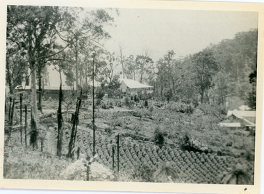
Kalorama Gap viewed from the South West in 1908. Ellis Jeeves' 'Mountjoy' is in the centre with the stables to the left. The raspberry patch belongs to Harry Walker and the building centre right to Edward Joseph Price. John Lundy-Clarke grew up in the Kalorama/Mt Dandenong area and later in life (1972-74) began to write a comprehensive history of the area working from an original settlement map in an effort to cover all areas.Black and white photograph showing an extensive raspberry crop in the foreground with a house and outbuilding in the centre and another dwelling centre right. Handwritten description on reverse by John Lundy-Clarke. 1908 view of Kalorama Gap taken from corner of Village Settlement LOTS 2 and 3 on Ridge (then Main Road) which crosses centre of picture with Walker’s driveway dropping left. Walker’s raspberry patch in foreground. “Mountjoy” in centre of picture with coaching stables on left. Price’s house and shop on right showing large cross room used by the Village Settlers for dancing. Mrs Hand’s “Beulah Tearooms” later Mt Dandenong North Post Office is above Price’s roof.kalorama gap, kalorama, harry walker, walker, edward joseph price, raspberry, mountjoy -
 Mt Dandenong & District Historical Society Inc.
Photograph, Edward Joseph Price and Grandson
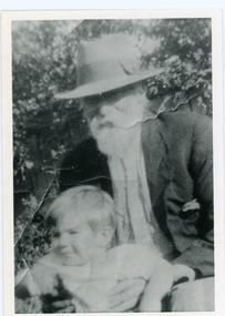
John Lundy-Clarke grew up in the Kalorama/Mt Dandenong area and later in life (1972-74) began to write a comprehensive history of the district working from an original settlement map in an effort to cover all areas. Edward Joseph Price took out Lot 1, Section 1 of the Village Settlement and became the first settler, moving his family up into a slab hut on his selection in 1896. Edward Joseph had two sons (Charles Joseph and Edward John) and a daughter (Kathleen Nathalie Caroline). Edward Joseph Price is holding his grandson Teddie, son of Edward John Price. Photo taken 1936.Black and white photograph in close up showing an old man with a white beard wearing a brimmed hat holding a male toddler under the arms. Reverse of photograph has handwritten description by John Lundy-Clarke.Edward Joseph Price and his grandson Teddie son of Edward John. E. Joseph was the first settler in the Village Settlement choosing LOT 1, part of which is still family property (1974). He worked for the surveyors who were marking out the blocks, and disregarded their advice as to which had the best soil, and so doing he obtained the best commercially. He died in 1943 leaving two sons & daughter. Edward John born 1899 died 1974. Charles born 1892 died 1958. Kathleen born 1895 died 1954. Wife Annie nee Ross died 1932.edward joseph price, edward john price, teddie price -
 Mt Dandenong & District Historical Society Inc.
Photograph, Home and Shop of Edward Joseph Price
John Lundy-Clarke grew up in the Kalorama/Mt Dandenong area and later in life (1972-74) began to write a comprehensive history of the district working from an original settlement map in an effort to cover all areas. Edward Joseph Price was the first settler to take up a lot (Lot 1, Section 1) in the Village Settlement. He built a slab hut and brought up his family in 1896. This photograph shows a newer home built in 1908. It had a section used as a shop and also had a large room built that was to be used for public gatherings. Health department regulations led to this being impossible. The house faced Ridge Road.Black and white close up photograph showing a building made from wooden boards with trees in the front. Reverse of photograph has handwritten description by John Lundy-Clarke.On Front STORE MT DANDENONG On Reverse Home and Shop of Edward Joseph Price LOT 1 SECT 1 erected in 1908 on site of earlier dwelling from which goods had been sold without a special room for shop. In picture the room on the extreme left was bedroom for boys Charlie and Ted (Edward John). Under the gable was a large room planned for public use but never used owing to Health Department Regulations. The narrow door (open) and window were the shop which was the district’s first newsagency. Window behind leaves at right was the kitchen. 1908-1912. Gabled portion is now part of home “Mirra Laken” 1975edward joseph price, store, shop -
 Mt Dandenong & District Historical Society Inc.
Photograph, Edward John Price aged 14
John Lundy-Clarke grew up in the Kalorama/Mt Dandenong area and later in life (1972-74) began to write a comprehensive history of the district working from an original settlement map in an effort to cover all areas. Edward John Price (1898 - 1974) was the son of early settlers on Lot 1 of the Village Settlement Edward Joseph Price and Annie (nee Ross) Price. He was the brother of Charles and Kathleen Price. Edward John married Myra Wilson in 1930.Black and white studio portrait showing well groomed boy holding a violin. Reverse of photograph has handwritten description by John Lundy-Clarke.Edward John Price aged 14. Son of Edward Joseph Price and Annie Ada nee Ross. Farmer, sawmiller, logging contractor,. proprietor of shop at Kew Junction 1935. Quarry master (Kilsyth). Father of Alan and Eddie J. A daughter died young. Married Myra Wilson 1930. Died 1974.edward john price, edward joseph price, annie price, annie ross, kathleen price, charles price -
 Mt Dandenong & District Historical Society Inc.
Photograph, Harmony Vale Homestead
This photograph of 'Harmony Vale' homestead was taken by Daisy Rowse c1917. It is a copy of the original. 'Harmony Vale' was the home built c1860 by early settler Jabez Richardson and his wife Sarah Ann. Jabez Richardson arrived in 1855 with the Child and Jeeves families. The building and barn stood until 1933. The name Harmony Vale was given to the early settlement.Black and white photograph with the roof of a house in centre surrounded by trees. harmony vale, daisy rowse, jabez richardson, richardson, homestead -
 Mt Dandenong & District Historical Society Inc.
Photograph, Alan Price
John Lundy-Clarke grew up in the Kalorama/Mt Dandenong area and later in life (1972-74) began to write a comprehensive history of the district working from an original settlement map in an effort to cover all areas. Alan Price was the son of Edward John Price and Myra (nee Wilson) Price. He had a brother Edward Joseph 2nd (Teddie). Alan and Teddie were the grandsons of early settlers Edward Joseph and Annie (nee Ross) Price. Alan Price worked at his brother's depot in Ringwood, in charge of mechanical equipment. He rode to and from work on his motorbike. Alan was killed in a motorbike accident on his way home from work in 1971. Alan married Patricia Guerin in 1960. They had five daughters and one son. The family had a house on part of Lot 5 facing Mt Dandenong Road.Black and white close up of man in suit and tie. Reverse of photograph has handwritten description by John Lundy-Clarke. Alan Price 1969. Son of Edward John Price and Myra nee Wilson. alan price, patricia guerin, edward joseph (teddie) price, edward john price, myra price, myra wilson, edward joseph price, annie price, annie ross, kalorama, accident -
 Mt Dandenong & District Historical Society Inc.
Photograph
The photograph is from the album of Ivy My Child. The area depicted would be looking across the Kalorama Valley with the visible roof tops being the homes of the early settler families. Ivy May Child (1910 – 1989) was the daughter of Arthur Edward (Ted) Child (1878 – 1964) and Ethel May Madden (1888 – 1970). Ted Child was the son of Matthew Francis Child (1839 – 1933) and Martha Jeeves (1857 – 1926). He was the grandson of one of the early pioneers Francis Child. Ivy grew up on the family property on Childs Road and took many photographs. Most of these are glued into her photo album. The album covered the years from c1927 – 1932. Ivy married Henry William Burgess (1906 – 1968) in 1944. The photographs remain in their original state in the album with individual copies made. Black and white photograph with trees and bushes in the foreground and hills in the distance. White shapes scattered throughout the centre are the roofs of buildings.Written below the photograph in album: Kaloramakalorama valley, kalorama -
 Southern Sherbrooke Historical Society Inc.
Information folder - Madigan Cottage
... marker of the Madigan family who were original settlers ...The buildings are probably rare remnant examples of their type in the local area and as such are significant to the settlement of Menzies Creek. The dwelling is significant as a longstanding marker of the Madigan family who were original settlers in the area. Its retention in its site close to the road boundary expresses and maintains a connection with early settlement and rural lifestyles in Menzies Creek over the last century. The old shed is of interest as a local example of bush construction, particularly in context with the cottage and farm environs. Without the life of the farm and other elements presumed now gone, its value is lessened.Folder containing information pertaining to the history of Madigan Cottage, Menzies Creek. NB: the shed was demolished in November 2001 and the cottage burned down sometime later. Contents:- Letter, Southern Sherbrooke Historical Society to Shire of Yarra Ranges, dated 9th March 2001, re. sale of property and need for it to be included in shire's Heritage Study. -Letter, shire to society, dated 20th March 2001, reply to above. -Letter, shire to society, dated 15th May 2001, follow-up to above, requesting more information. -Letter, society to shire, dated 30th May 2001, responding to above and including a copy of information previously sent to Chris Johnston, Heritage Study consultant. -Letter, society to shire, undated, noting intention to lodge an objection to proposed application for development on site. -Letter, shire to society, dated 22nd October 2001, advising of consultation meeting. -Yarra Ranges Shire Heritage Study Place Nomination form for Madigan Cottage, prepared by Marian Matta, includes nine colour photos and diagram showing where photos were taken from. -Black and white copies of photos. -A3 copy of real estate advertisement, "Mount Evergreen Estate" dated 21st April 1924. -A3 map showing proposed resubdivision boundary variation, drawn up for Mr. P. Melville, undated but 1990s. -Copy of application for a planning permit, dated 6th August 2001, including letter by Nick Jonkers describing proposed new buildings, site map showing current vegetation, letter re. proposed removal of vegetation, subdivision plan dated March 1998, and larger scale map printed from shire website on 10th August 2001. -5 A3 sheets showing site and house plans drawn up for Mr & Mrs N. Jonkers, dated July 2001.madigan cottage, menzies creek, madigan family, mount evergreen, patrick madigan -
 Otway Districts Historical Society
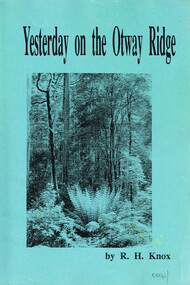
Book, R.H. Knox, Yesterday on the Otway Ridge
A history dealing with the Otways from Barramunga to Lower Gellibrand by R.H. Knox, the son of an original selector, and his wife, the daughter of another original selector.Yesterday on the Otway Ridge. R.H. Knox. 1st ed. np; R.H. Knox; nd. ii, 192 p.; illus. Soft cover.otway ridge; r.h. knox; history; settlers; timber; sawmilling; farmer; transport; -
 Queenscliffe Maritime Museum
Functional object - Fishermans Cottage, Built in 1870/1880 for Thomas and Anna Ikin
This low-lying northern-most tip of Queenscliff saw its physical origins in 1863 with allotments let to a burgeoning fishing community previously accommodated on the site of the current railway station and whose construction in 1879 necessitated eviction. Among this community, Chinese fishermen are thought to be of the first international settlers. The success of the fishermen’s settlement was due in part to commercial trading prospects the railway afforded and the size of catch available to those fishing in Bass Strait. Salmon, snapper and particularly barracouta led to the success of the local industry.Original Fishermans Cottage previously located at Swan Bay end of Bridge Street Queenscliff. Timber - Weatherboardfishermen's cottage, fishermen's flat, queenscliff -
 Buninyong & District Historical Society
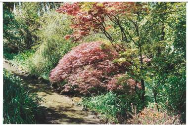
Photograph - Original Colour Photograph, Ann Beggs Sunter, Gardens at Lal Lal House, Yendon, October 1993
Early settlers, Fisken family's dwelling.Colour photo part of Garden at Lal Lal House, Yendon, cottage-style garden, gravel path curving to left, Japanese Maple with autumn foliage centre.lal lal house, yendon, garden, fisken -
 Buninyong & District Historical Society
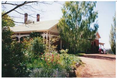
Photograph - Original Colour Photograph, Ann Beggs Sunter, Lal Lal House, Yendon, side view, October 1993
Early settlers, Fisken family's dwelling.Colour photo Lal Lal House, Yendon, Victorian single story, red brick, gabled tin rooflal lal house, yendon, garden, fisken -
 Buninyong & District Historical Society
Photograph - Original Colour Photograph, Ann Beggs Sunter, Lal Lal House, Yendon, October 1993
House built for early settler Archibald Fisken.Colour photo Lal Lal House, Yendon, cottage-style garden, gravel driveway, Birch Tree centre.lal lal house, yendon, garden, fisken -
 Buninyong & District Historical Society
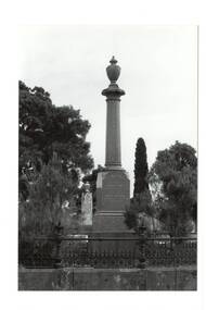
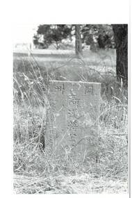
Photograph - Original B/W Photograph, Clive Brooks, Buninyong Cemetery, Monument for George Innes and his daughter, 9/4/1994
Part of series to record changes in BuninyongGrave of Buninyong Pioneer.A B/W and a colour photo, monument, polished granite, pillar on engraved plinth, urn cap, cast iron fence, for early settler George Innes and his daughter.. in Buninyong Cemetery.buninyong, cemetery, headstone, graves, innes, king of splitters, pound, buninyong defiance mine -
 Buninyong & District Historical Society
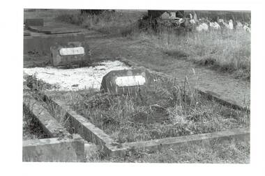
Photograph - Original B/W Photograph, Clive Brooks, Buninyong Cemetery, graves of (Francis) Moss and Tresise, 9/4/1994
Part of series to record changes in BuninyongGrave of Buninyong Pioneer.A B/W and a colour photo, monument, polished granite, pillar on engraved plinth, urn cap, cast iron fence, for early settler George Innes and his daughter.. in Buninyong Cemetery.buninyong, cemetery, headstone, graves, francis moss, tresise, apples -
 Buninyong & District Historical Society
Photograph - Original B/W Photograph, Clive Brooks, Buninyong Cemetery, engraved headstone for Chinese grave, 9/4/1994
Part of series to record changes in BuninyongGrave of early Buninyong Chinese settlers.A B/W photo , Buninyong Cemetery, engraved headstone for Chinese grave.buninyong, cemetery, headstone, graves, chinese -
Kew Historical Society Inc
Archive (Sub-series) - Subject File, DERRICK family, 1958
Various partiesReference, Research, InformationSecondary Values (KHS Imposed Order)The Derrick family were early settlers in Kew. Derrick Street is named after them. The Derrick file includes minutes of meetings at which Derrick family descendants attended, correspondence, research notes on the Derrick Family, maps of the Derrick landholding in Kew (and a photocopy of the Certificate of Title), and photocopy of a letter from John Derrick to Francis Barnard (original in archive). There are also sundry newspaper articles/clippings.derrick family, kew -- history -- pioneersderrick family, kew -- history -- pioneers -
 Kew Historical Society Inc
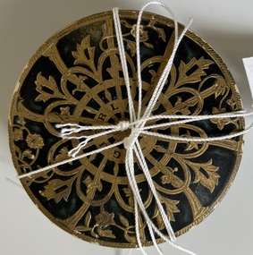
Accessory - Container of face powder, Guerlaine, 1920s
The French Collection was donated to the Society in 2022. This collection includes documents, artworks, books, costumes and artefacts belonging to two families. A number belonged to, or were made by the grandparents of the donor: Vida May Wing and her husband Hubert Charles McDonald. [Other items belonging to Vida and Hubert are in the collections of the Australian Performing Arts Museum and Museum Victoria.] A second significant group of objects were gifts made to the donor's family by Lucy (Jean) Hornby of Queen Street, Kew whose family had been early settlers in the district. Vida May Wing was born in Richmond in 1882. A noted teacher of plain, fancy and step dancing, during the first two decades of the twentieth century she held annual fancy dancing and floral balls, where her pupils were the performers. In 1916, she married Hubert Charles McDonald. She died in 1959.Round box of Guerlaine [established 1828] face powder. The name of the manufacturer is embossed on the base. The navy blue and gold cardboard container is filled with the original powder by Guerlain Shalimar, 'Ocre Doree'. It belonged to to Vida May McDonald.Reverse: "Guerlaine"guerlaine, vida may wing, cosmetics, face powder