Showing 620 items
matching park j
-
 City of Moorabbin Historical Society (Operating the Box Cottage Museum)
Programme - Memorial Service - Bentleigh Recreation Reserve, Unveiling Memorial Tablet to Our Fallen Soldiers, 1918
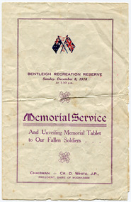
The memorial service held at the Bentleigh Recreation Reserve on Sunday, December 8, 1918. It was largely attended. The president of the Sire, Cr. D. White, was introduced to those present, by Cr T Marriott. Mr O. R. Snowball, M.L.A., unveiled the memorial tablet, which was inscribed as follows :-- “To the memory of Bentleigh boys who died for their country in the Great War 1914.18,. Greater love hath no Man than this, that a man lay down his life for his friends.” OUR FALLEN HEROES Austin, R J, (M.M.); Mitchell, R A; Baker, O R; Manfield G S; Bevis, D E; Norris, H; Crutchfield, C; Odgen, A.; Dodson, H E; Perry, L.; Dunigan, F J; Sharpin, G; Hill, G; Searle, J H; Jones, C; Smith, E R Bentleigh residents remembers the "Bentleigh Boys" that were killed in World War One, the sons of pioneer familiies of the districtFour page Programme, for the Memorial Service and unveiling of memorial Table to the Shire of Moorabbin's fallen Soldiers.world war one, wwi, memorial, bentleigh recreation reserve, moorabbin, bentleigh, shire of moorabbin, austin, mitchell, baker, manfield g s, bevis, norris, crutchfield, odgen, perry, dunigan, sharpin, hill, searle, smith, dodson -
 City of Moorabbin Historical Society (Operating the Box Cottage Museum)
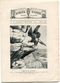
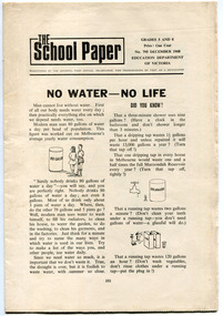
Magazine - The School Paper for Grades III and IV (1948) No 569 to 597; Feb 1948 to Dec 1948, 11 Editions, 1948
School Papers were issued to the children going to school in the state of Victoria by the Education Department for a cost of 1 penny per issue. These copies were collected and saved by one of the pioneer families of City of Moorabbin.Issued by the Education Department of Victoria, printed J. J. Gourley, Government Printer, Melbourne The School Paper For Grades III and IV (1948)EDUCATION DEPARTMENT VICTORIA / SCHOOL PAPER / For Grades III and IV (1948)education, victoria, australian history, victorian education department, marriott william, marriott geoff, market gardeners, pioneers, moorabbin shire, henry dendy special survey brighto 1841, east bentleigh state school no. 2083 -
 City of Moorabbin Historical Society (Operating the Box Cottage Museum)
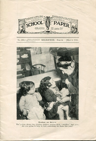
Magazine - The School Paper for Grades III and IV (1949) No 293 May and No 597 September, 2 editions, 1949
These School Papers were issued to the children going to school in the state of Victoria by the Education Department for a cost of 1 penny per issue. This copy was collected and saved by one of the pioneer families of City of Moorabbin.Issued by the Education Department of Victoria, printed J. J. Gourley, Government Printer, MelbourneThe School Paper For Grades III and IV (1949) 12 pagesEDUCATION DEPARTMENT VICTORIA / SCHOOL PAPER / For Grades III and IV (1949)education, victoria, australian history, victorian education department, marriott william, marriott geoff, market gardeners, pioneers, moorabbin shire, henry dendy special survey brighto 1841, east bentleigh state school no. 2083 -
 City of Moorabbin Historical Society (Operating the Box Cottage Museum)
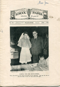
Magazine - The School Paper for Grades III and IV (1950), 1949
These School Papers were issued to the children going to school in the state of Victoria by the Education Department for a cost of 1 penny per issue. This copy was collected and saved by one of the pioneer families of City of Moorabbin.Issued by the Education Department of Victoria, printed J. J. Gourley, Government Printer, MelbourneThe School Paper For Grades III and IV (1950) 12 pagesEDUCATION DEPARTMENT VICTORIA / SCHOOL PAPER / For Grades III and IV (1950)education, victoria, australian history, victorian education department, marriott william, marriott geoff, market gardeners, pioneers, moorabbin shire, henry dendy special survey brighto 1841, east bentleigh state school no. 2083 -
 City of Moorabbin Historical Society (Operating the Box Cottage Museum)
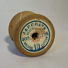
Textile - Sewing Equipment, Cotton reel ' Coates' 400yds, c20thC
An example of the Cotton Reels used by residents of City of Moorabbin and Australia in 20th CAn example of the Cotton Reels used by residents of City of Moorabbin and Australia in 20th CA wooden cotton reel with some white thread remaining from the 400yards when made Around Top of reel J&P COATS MACHINE 10 COTTON / BEST S........ / 400 YDS Base damaged 366 METRES -
 City of Moorabbin Historical Society (Operating the Box Cottage Museum)
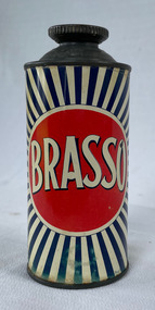
Equipment - BRASSO, Reckitt and Colman Ltd, Metal Polish, 20thC
Reckitt & Sons' opened a branch in Sydney in1886. Brasso was developed by Reckitt & Sons in 1905. In 1938 Reckitt and Sons merged with J. and J. Colman to become Reckitt and Colman Ltd.Brasso was used by most Housewives for cleaning and polishing Kitchen Equipment in the City of Moorabbin during 20thC Metal container with blue sun burst effect, with a red circle with 'BRASSO' printed, in white and blue, inside. The instructions are printed on the back. FRONT: 'BRASSO' Back: Picture of the Royal Coat of Arms - By appointment to Her Majesty Queen ElizabethII. Suppliers of Metal Polish Reckitt & Colman Ltd. BRASSO Metal Polish for polishing Brass, Copper, Zinc, Steel, Pewter etc. SHAKE WELL Apply with a soft cloth. Polish off with a dry, soft cloth preferably before the polish has completely dried. DO NOT PLACE THIS TIN CLOSE TO THE FIRE Made in Australia by Reckitt & Colman (Australia) Ltd. No. 6 - Contents 6½ Fl oz when packed. brasso, metal polish -
 City of Moorabbin Historical Society (Operating the Box Cottage Museum)
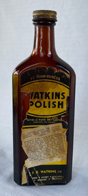
Domestic object - Watkins Polish, J. R. Watkins Co (USA), 20thC
The J. R. Watkins Co. opened its first overseas branch in Australia in 1935. The J. R. Watkins built a large factory at Highett on a six acres on the east side of Nepean Highway (no. 1123) in 1954. The J. R. Watkins company was founded in 1868 in Plainview, Minnesota USA, moving to Winona in 1885, by J. R. Watkins.Example of industry in the City of Moorabbin.Amber glass bottle with a metal screw on lid. A paper label is on the front of the bottle 'Watkins Polish" printed in yellow, black and white.PRINTED ON LABEL: 11 Fluid ounces - WATKINS POLISH - Gives a hard dry lustre excellent for Dusting For cleaning, dusting and polishing furniture, pianos, woodwork, linoleum, hardwood floors and all polished surfaces. Directions: If the article to be polished is dirty or gummy, clean it by washing with mild soap and warm water. Apply Watkins Polish with a damp, soft cloth (Dampened with water and wrung almost dry). The Polish may be poured on the damp cloth or on the surface to be polished. In either case rub it all with a dry cloth to obtain a high polish. When dusting, dampen the cloth with Watkins Polish - it keeps down the dust and gives a lustre which is neither greasy not gummy. The J. R. Watkins Co. Melbourne - Sydney - Adelaide - Kogarah EMBOSED ON BOTTLE: "The J.R.Watkins co. Made in Australia" the j. r. watkins co, highett, polish -
 City of Moorabbin Historical Society (Operating the Box Cottage Museum)
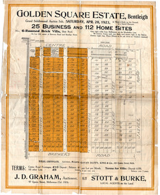
Flyer - Golden Square Estate, Bentleigh, 1923
Land sales in the Municipality of Moorabbin increased when the train line from the City to Frankston was electrified.Example of the progress of the Municipality of MoorabbinThe train line from the city to Frankston was electrified which intensified the sale in the municipality of Moorabbin, particularly land which was in the vicinity of the railway stations.Golden Square Estate, Bentleigh - J. D. Graham, Stott & Burke - 25 business sites and 112 home sitescentre road, brewers road, jasper road, robert street, mitchell street, daley street, bendigo avenue, auction, real estate, moorabbin, bentleigh -
 City of Moorabbin Historical Society (Operating the Box Cottage Museum)
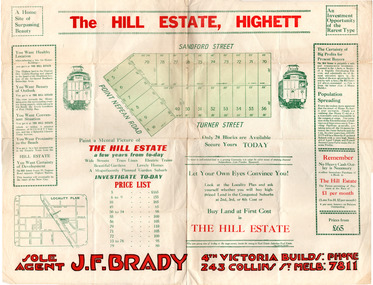
Flyer - Hill Estate, Highett
Land sales in the Municipality of Moorabbin increased when the train line from the City to Frankston was electrified.Example of the progress of the Municipality of MoorabbinAdvertising flyer for auction of real estate sales - plan of building blocks for saleThe Hill Estate, Highett - 24 Housing Blocks - J. F. Bradypoint nepean road (nepean highway), turner street, sanford street, real estate, highett -
 City of Moorabbin Historical Society (Operating the Box Cottage Museum)
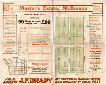
Flyer - Master's Estate, McKinnon
The end of WWI bought new interest in residential land. This sale must have been just before the electrification of the railway line from the city to Frankston which happened in 1922.Example of the progress of the Municipality of MoorabbinAdvertising flyer for auction of real estate sales - plan of building blocks for saleMaster's Estate, McKinnon - 99 Blocks - Agent: J. F. Bradymanchester road (now mckinnon road), tucker road, moylan street, lancaster street, preston street, real estate, bentleigh, mckinnon, moorabbin -
 City of Moorabbin Historical Society (Operating the Box Cottage Museum)
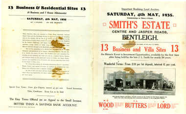
Flyer - Smith Estate, Bentleigh, 1935
This Land was owned by one the pioneers of Bentleigh Mr John Logan Smith (1860-1932), who owned J. L. Smith Hay & Grain Store, on the corner of Jasper and Centre Road, Bentleigh. The family sold the property after Mr Smith passed away.Example of the progress of the Municipality of MoorabbinAdvertising flyer for auction of real estate sales - plan of building blocks for sale - PhotocopySmith's Estate, Bentleigh 13 Home Sites and 13 Business Sites Auction Saturday 4 may 1935 - W. H.Wood, T. A. Butters, H. Lordjohn logan smith, centre road, jasper road, bentleigh, aution, real estate -
 City of Moorabbin Historical Society (Operating the Box Cottage Museum)
Flyer - Smith's Estate, Highett
The train line from the city to Mordialloc was built which opened up the land for housing development. The section bounded by Peterson Street Telford Street and Highett Road is now Peterson Street Reserve.Example of the progress of the Municipality of MoorabbinAdvertising flyer for auction of real estate sales - plan of building blocks for saleSmith's Estate, Highett - J. F. Bradyhighett, real estate, highett road, hillside street (no longer exists), peterson st, frederico st, tolhurst st (no longer exists), wickham road, danson street, peterson street reserve -
 City of Moorabbin Historical Society (Operating the Box Cottage Museum)
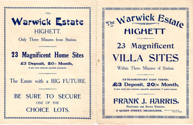
Flyer - Warwick Estate, Highett
The train line from the city to Frankston was electrified in 1922 which intensified the sale in the municipality of Moorabbin, particularly land which was in the vicinity of the railway stations.Example of the progress of the Municipality of MoorabbinAdvertising flyer for sale of real estate sales - plan of building blocks for saleWarwick Estate Highett, 23 housing blocks - Frank J. Harriswickham road, herbert street, highett, real estate -
 City of Moorabbin Historical Society (Operating the Box Cottage Museum)
Magazine - The School Paper, Grades 5 and 6, No. 795 December 1968 and Grades 3 and 4, No. 809 December 1968, The last issue of The School Paper, 1968
These School Papers were issued to the children going to school in the state of Victoria by the Education Department for a cost of 1 cent per issue. These were the last edition of the School Paper to be printed. This copy was collected and saved by one of the pioneer families of City of Moorabbin.Issued by the Education Department of Victoria, printed J. J. Gourley, Government Printer, MelbourneThe School Paper For Grades 5 and 6 (1968) and For Grades 3 and 4 (1968)EDUCATION DEPARTMENT VICTORIA / SCHOOL PAPER / For Grades III and IV (1950)education, victoria, australian history, victorian education department, marriott william, marriott geoff, market gardeners, pioneers, moorabbin shire, henry dendy special survey brighto 1841, east bentleigh state school no. 2083 -
 City of Moorabbin Historical Society (Operating the Box Cottage Museum)
Magazine - Meteor The School Paper 1971 - 11 Editions, Albert J Mullett Government Printer for Education Dept Victoria, 1971
Issue no 807 - 828 of The School Paper Feb 1970 - 11 Editions issued for Victorian State School students by Education Department of Victoria .Issued by the Education Department of Victoria, printed A. C. Brooks, Government Printer, MelbourneMagazines distributed by the Education Department of Victoria to State School Children.METEOR / The School Paper / February 1971 to December 1971 Education Dept of Victoria Signed Amanda Cook education, victoria, australian history, victorian education department -
 City of Moorabbin Historical Society (Operating the Box Cottage Museum)
Book - A Journey of Faith - The Stained Glass Windows of St Paul's Bentleigh Holy Trinity Parish, by Patrick Ferry, 2015
St Paul's Church is in Jasper Road, Benlteigh. A foundation stone reads " This stone symbol of Christ, Chief corner stone of the church was blessed and set by His Grace Archbishop Simonds 13th November 1960, T O'Sullivan P.P. S. J. Morgan and Associates Architect H.P. Yunken Pty Ltd Builder". The stained glass windows were commissioned by Father Timothy O'Sullivan and the artist was Alan Sumner. The window were progressively installed from 1961, and took nearly 20 years to complete.St Paul's Catholic Church Bentleigh was integral to the spiritual well being and social life of the early settlers.A book about the stained glass windows in St Paul's Catholic Church in Jasper Road, Bentleigh - containing photos and diagram.city of moorabbin, county of bourke, shire of moorabbin, market gardeners, nepean highway, st paul's catholic church, bentleigh, jasper road, religion -
City of Moorabbin Historical Society (Operating the Box Cottage Museum)
Booklet - Souvenir History of the Church of Christ Cheltenham - 80th Anniversary May 2 & 3, 1937, by J. Ernest Allan, 1937
Cheltenham Church of Christ was opened in 1878 and is still in use today. Built on Chesterville Road, Cheltenham.Cheltenham Church of Christ was opened in 1878 and was integral to the spiritual well being and social life of the early settlers.Booklet 19 pages with typed text and photosearly settlers, parish of moorabbin, city of moorabbin, county of bourke, shire of moorabbin, market gardeners, cheltenham, nepean highway, church of christ cheltenham, religion, chesterville road -
City of Moorabbin Historical Society (Operating the Box Cottage Museum)
Booklet - One Hundred Years - Church of Christ Chesterville Road, Cheltenham 1857-1957, by J. Ernest Allan, 1957
Cheltenham Church of Christ was opened in 1878 and is still in use today. Built on Chesterville Road, Cheltenham.Cheltenham Church of Christ was opened in 1878 and was integral to the spiritual well being and social life of the early settlers.Booklet 12 pages with typed text and photosearly settlers, parish of moorabbin, city of moorabbin, county of bourke, shire of moorabbin, market gardeners, cheltenham, nepean highway, church of christ cheltenham, religion, chesterville road -
 City of Moorabbin Historical Society (Operating the Box Cottage Museum)
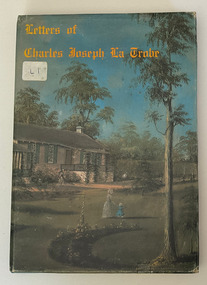
Book, Charles Joseph La Trobe, 1801-1875, Letter of Charles Joseph La Trobe, 1975
96p.,[12]p. of plates(part col.) : ill.non-fictioncharles joseph la trobe, victoria -
 City of Moorabbin Historical Society (Operating the Box Cottage Museum)
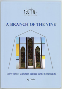
Booklet, Davis, A. J. (Jack), St John's Anglican Church, Bentleigh : A Branch of the Vine : 150 Years of Christian Service in the Community, 2004
The 150 Anniversary of St John's Anglican Church in Tucker Road, Bentleigh - a narrative about St John's, Bentleigh.58pp ; ill ;non-fictionThe 150 Anniversary of St John's Anglican Church in Tucker Road, Bentleigh - a narrative about St John's, Bentleigh.st john's, st john's church, tucker road, benteligh, religion, moorabbin -
 City of Moorabbin Historical Society (Operating the Box Cottage Museum)
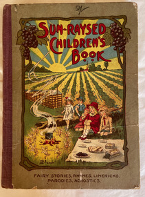
Book, DeGaris, C. J. (Clement John), Sun-Raysed Children's Book : Fairy Stories, Rhymes, Limericks, Parodies, Acrostics, 1919
Contains prize-winning fairy stories, rhymes, limericks, etc. from entries in the Sun-raysed competitions of January, 1919.52 p. : ill. (some col.) ;fictionContains prize-winning fairy stories, rhymes, limericks, etc. from entries in the Sun-raysed competitions of January, 1919.fairy tales, dried fruit, children's literature -
 City of Moorabbin Historical Society (Operating the Box Cottage Museum)
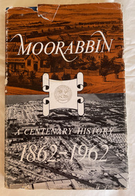
Book, Thomas Arthur Sheehy, Moorabbin : a centenary history, 1862-1962, 1962
History of Moorabbin and surrounding suburbs that were part of the Moorabbin Roads Board, Moorabbin Shire, Moorabbin Council.96 p., 24 leaves of plates : ill. ;non-fictionHistory of Moorabbin and surrounding suburbs that were part of the Moorabbin Roads Board, Moorabbin Shire, Moorabbin Council.moorabbin, moorabbin history -
 City of Moorabbin Historical Society (Operating the Box Cottage Museum)
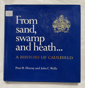
Book, Murray, Peter R. et al, From sand, swamp and heath : a history of Caulfield, 1980
278p. : ill., graphs, maps, portrs. includes index.non-fictioncaulfield history, caulfield council -
 Bendigo Historical Society Inc.
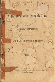
Book - BENDIGO SALEYARDS COLLECTION: THE BYE-LAWS AND REGULATIONS OF THE SANDHURST CORPORATION
Book with faded and stained pink cover. Much of the book held together with sticky tape. Titled The Bye-laws and Regulations of the Sandhurst Corporatiion, in connection with Local Government 1889. Printed by J. B. Young, General Printer, Book-Binder, Lithographer, &c., Lyttleton Terrace. Contained in the book are Regulations on buildings, parks, carriages, animals, noxious trades shops and tents.bendigo, council, cattle markets, bendigo saleyards collection - the bye-laws and regulations of the sandhurst corporation 1889, j b young, henry hattam, dugald macdougall, ebenezer neill, john buckley, j a woodward, w d c denovan, w g jackson, john delbridge, s h mcgowan, jacob cohn, j w colville, alexander bayne, d c sterry, john a woodward, patrick hayes, t jefferson conmnelly -
 Bendigo Historical Society Inc.
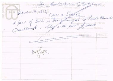
Document - THE AUSTRALIAN SKETCHER 1873
Handwritten, detailed account of Hospital Sunday at Sandhurst. It mentions the crowds coming into town, the procession, and the day’s entertainment at the Reserve. Also mentions the donations raised for charity. Also a number of small pages titled Facts & Scraps. Mentions a number of daily happenings and the bells at St. Paul's Church.event, entertainment, sandhurst, the australian sketcher 1873, rev mr croxton, the bendigo advertiser, hallas' band, northcott's regimantal band, captain moorhead, captain boyd, lieutenant sibley, lieutenant henderson, mr morrison, bendigo rifles, major taylor, captain joseph, lieutenant blackham, bendigo hotel, bank of victoria, prince alfred, mr abbott, st paul's church bells, hustlers mine, prince bismarck, james park, bell, william hartlett, mr williamson, mr purcell, connell watson & hogarth, mr j b watson, the engineers engine-drivers and blacksmiths association, melbourne botanical gardens, mr hodgkinson, baron von muellerus, patrick hugo mchugh, golden fleece mine, orpheus c kerr, jones, the victorian racing club, mr walker, spencer, robert chambers's index to heirs-at-law legatees missing friends and persons advertised for during 150 years past, mr higinbotham, mr d r morrison, mr mccosh, mr hicks, carlisle company, james hamilton, samuel rochford, royal hustlers claim, william mycroft, rifle brigade hotel, mr randall, the right rev dr gould, r m s s china, james kennedy -
Bendigo Historical Society Inc.
Document - JUNE PARRY COLLECTION: MINING IN BENDIGO - LETTER TO MISS J. PARRY
Typed letter from W. M. Flentje to Miss J. Parry, Secretary, Bendigo Historical Society referring to the preservation of land to preserve mining relics. Part of the land may extend into private property and some crown Land. He says 'If the Land Conservation Council should decide to add the Crown land part of the area to the Forest Park, then preservation of the area will become our responsibility.' Letter written Forests Cmmission Victoria letterhead. It has a green logo on toe top of two trees, one eucalypt type and the other, a pine. Letter dated 10th December, 1976.document, memo, mining in bendigo, mining in bendigo, letter to miss j parry, forests commission victoria, whipstick forest park advisory committee, w m flentje -
 Bendigo Historical Society Inc.
Book - SCRAPBOOK, 1950S EPHEMERA
... . Mrs J. Braddy, Dixons Caravan Park, Marong written on the back.... J. Braddy, Dixons Caravan Park, Marong written on the back ...Yellow spring back Spirax No. 578 Sketch Book. Book contains Menu/Programmes, In Memoriam King George VI, thank you cards, business cards, Golden Square Methodist Church Centenary, Boort Lodge No. 183 Golden Jubilee Meeting, Mannequin Parade Program, serviette, business stationary, advertising for Fair-View Upholsterers, musical and concert tickets, members badges, Bendigo Masonic Meeting, chemist's label, marriage invitations, Greenvale Kennels stationary, Bendigo Rotary dinner menu and programme, Past Presidents of Rotary, Christmas Greeting cards, Business Cheques, 3BO Duty Pass, Templeton's Sports Store, Sea Lake ticket, Bendigo Agricultural Show Society 1953 Prize Tickets for First, Second, Third, Champion and Highly Commended. Printing in book by Ray Purtill. Mrs J. Braddy, Dixons Caravan Park, Marong written on the back.book, bendigo, bendigo organisations & businesses, book, scrapbook, mrs j braddy, ray purtill, bendigo organisations, bendigo businesses, see link -
 Bendigo Historical Society Inc.
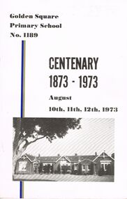
Book - GOLDEN SQUARE LAUREL STREET P.S. COLLECTION: GOLDEN SQUARE PRIMARY SCHOOL CENTENARY, August, 1973
Three copies of the Golden Square Primary School No. 1189 Centenary 1873 - 1973 booklet. Centenary held on August 10th, 11th, and 12th, 1973. Book contains some photos, history, newspaper articles, List of Head Teachers, List of School Inspectors, Presidents of the School Committee, Presidents of the Mothers Club, Honor Rolls, and Names of Teachers.Cambridge Press Bendigo.education, primary, golden square laurel st p.s., golden square laurel street p.s. collection - golden square primary school centenary 1873 - 1973, b comte, l raeburn, d munari, j w hendry, f kinsman, mrs l jackman, mrs e bradley, mrs l mckerlie, mrs j wynne, mr n pinch, cambridge press, foley's bendigo caravan park -
 Bendigo Historical Society Inc.
Document - BENDIGO AND SANDHURST GOLF CLUBS: AN EARLY HISTORY, 21st August, 1901
(Draft) of early history of Bendigo Golf Club and Sandhurst Golf Club awaiting information to complete from documents sought from the Titles Office. Mention of: Prince Patrick Hotel (Fitspatrick's) , Eaglehawk; Tom Glover; ''Woodbury'' property' of Rupert Putnam; Ben Roper; Turf Tavern, Epsom; Bendigo Golf Club opening 21st Aug 1901; ''Ascot Park''; care of the new 18 hole course (mown by sheep!). Two copies.bendigo, clubs, bendigo golf club, prince patrick hotel (fitzpatrick's), eaglehawk, mr tom glover's, rupert putnam, "woodbury", drs catford, green, ker and lyons, messrs w. cook, j. smalley, p. samiley, messrs. mueller, sagar. myor, cr. ryan. the turf tavern -
 Bendigo Historical Society Inc.
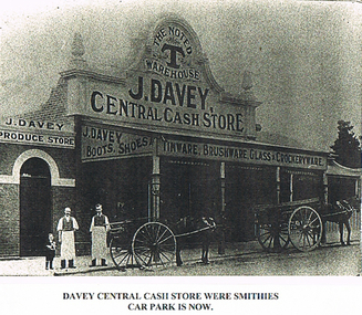
Photograph - LONG GULLY HISTORY GROUP COLLECTION: DAVEY CENTRAL CASH STORE
Black and white photocopy of a photo of the Davey Central Cash Store printed on cream paper. The store has the name and a number of wares which they sold painted on the top edges of the veranda. there are two horse and carts and two men and a pony standing out the front of the store. Printed on a piece of white paper stuck to the paper is - Davey Central Cash Store were Smithies Car Park is now.bendigo, history, long gully history group, the long gully history group - davey central store, j davey, the noted t warehouse