Showing 22310 items
matching parks
-
 Kew Historical Society Inc
Photograph - Flooding of the Yarra Valley at Kew East, 1974
Flooding of the Yarra Valley, including that section of the Yarra bordering Kew and Kew East in the north and west of the municipality, was a regular occurrence. Extreme flood events of the Yarra River are recorded to have occurred in 1891, 1901, 1916, 1923 and 1934. The Municipality of Kew's response to these floods was to enact planning decisions restricting residential development in flood prone areas following the floods of 1916, 1921 and 1934. While floods continued after the development of the Upper Yarra Reservoir (construction 1948-57), the regularity and extent of these inundations diminished. During the nineteenth century, the land abutting the south side of the Yarra in Kew was devoted to dairy farming. In the twentieth century, before and after the construction of the Eastern Freeway, much of this low-lying area was used as golf courses and public parks.Late example of the capacity of the Yarra Valley at Kew to flood, even though drainage works and the Upper Yarra Reservoir had reduced their regularity.Original black and white print photograph of the low-lying land at East Kew under floodwater on 16 May 1974. The photograph is of Hyde Park looking north-east.Annotation verso: "Hyde Park looking nth-east / Flood Level / 16 May 1974 11.15am / R.L. 46.61"floods, yarra river, hyde park -
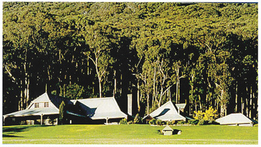 Marysville & District Historical Society
Photograph (Item) - Colour photograph, Unknown
A colour photograph of Howen Park.A colour photograph of Howen Park.howen park, photograph -
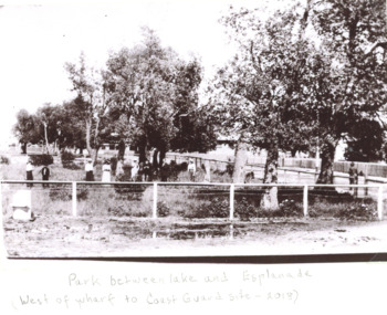 Lakes Entrance Historical Society
Photograph - Recreation Park Esplanade Lakes Entrance 1910, Recreation Park Esplanade Lakes Entrance, 1910 c
... Parks ...Black and white photograph of people in a fenced park which was situated west of the Eastern wharf between the lake and Esplanade Lakes Entrance Victoriaparks, social history, roads and streets -
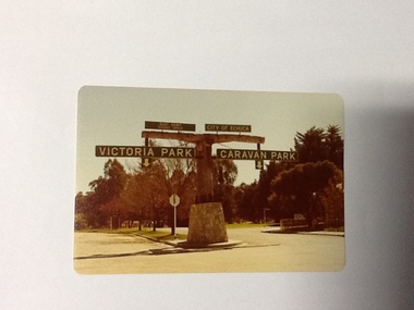 Port of Echuca
Colour Photograph, Approx.1979
In 1869 the Council moved to name this park "Victoria Park. The cricket pitch construction began in 1873 and major improvements to the ground were undertaken in 1881. It is still the primary sporting ground in Echuca, offering AFL football oval, cricket pitch and nets, athletics and entry to the Echuca boat ramp and the natural bush land of the scenic drive. It also houses Echuca Council caravan park. The signage in this photograph is no longer there and the enterance to the caravan park has moved.This area of Echuca has historically been a major recreational area for the town. Being the primary sporting ground since its establishment in 1869., the area has a number of sporting and recreational facilities for the people of Campaspe Shire, from natural bush walks in and along the Murray river to more formal facilities such as AFL football ground, firefighting training area, netball courts, cricket pitch and nets, and grass tennis courts. Colour photograph (post-card size) of directory signs to entrance of Victoria Park, Echuca taken facing north. Two driveways are shown, to the east "Caravan Park" and to the west , "Victoria Park", "Boat ramp", " Scenic drive"Printed in black on the reverse:"this paper manufactured by Kodak"echuca, port of, echuca council caravan park, victoria park, echuca, echuca-tourist attraction -
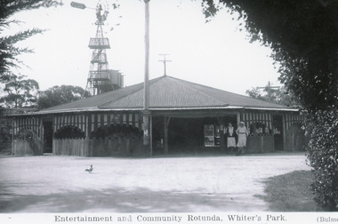
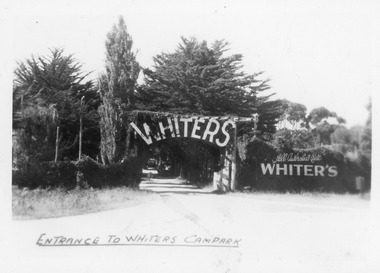 Lakes Entrance Historical Society
Postcard - whiters camp park, Bulmer H D, 1945c
One of a set of eight small format postcardsBlack and white small format postcard taken from road, showing entrance, treed with signage above double gated driveway at Whiters Camp Park. Sign on fence at eastern side of gateway, Still Australia's Best. Lakes Entrance VictoriaEntrance to Whiters Camp Parkresort, tourism, recreation -
 Lakes Entrance Historical Society
Photograph, Bulmer H D, Whiters Camp Park, 1940c
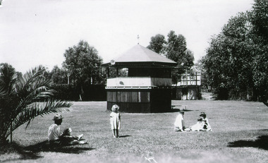
Black and white photograph showing original band rotunda, Whiters Camp Park, surrounded by manicured lawns, five people in foregound. Lakes Entrance VictoriaThe Band Rotunda, Whiters Camping Park, Lakes Entranceresort, recreation -
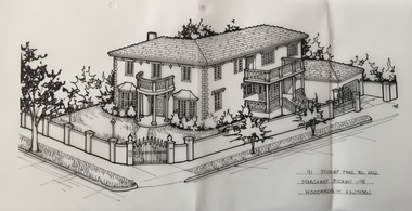
 Kew Historical Society Inc
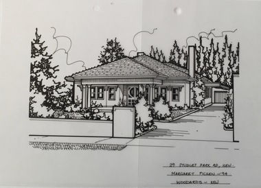
Drawing - Property Illustration, Margaret Picken, 29 Studley Park Road, Kew, 1994
After training as a Cartographic Draftsman within the mining industry, I worked as a property illustrator for real estate firms in the eastern suburbs of Melbourne for 22 years from 1983. I initially photographed houses with a Polaroid camera and made a 'thumbnail' sketch while there. The photos were used to scale off a sketch in pencil and then that sketch was overlaid with drafting film and the 'pen and ink' completed. The pens I used were the Rotring ‘Rapidigraph’ drafting pens. The ink was also made by Rotring (German).The film was ‘Rapidraw’, polyester drafting film, double matte. It takes a very fine line and doesn’t bleed. As well as house sketches, there were often floor plans and site plans ordered. Aerial sketches were ordered when the property needed an overall view. (Margaret Picken, 2020)This drawing is one of a series created by Margaret Picken for a number of real estate agents in Melbourne between 1983 and 2005. Each work is signed and dated by the artist.Gift of Margaret Picken, 2020Pen and ink architectural drawing on drafting film of 29 Studley Park Road, Kew by Margaret Picken.29 STUDLEY PARK RD., KEW / MARGARET PICKEN ~94 / WOODARDS ~ KEWartist -- margaret picken 1950-, architectural drawings -- houses -- kew (vic.), 29 studley park road - kew (vic) -
 Kew Historical Society Inc
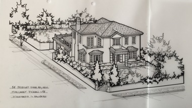
Drawing - Property Illustration, Margaret Picken, 55 Studley Park Road, Kew, 1998
After training as a Cartographic Draftsman within the mining industry, I worked as a property illustrator for real estate firms in the eastern suburbs of Melbourne for 22 years from 1983. I initially photographed houses with a Polaroid camera and made a 'thumbnail' sketch while there. The photos were used to scale off a sketch in pencil and then that sketch was overlaid with drafting film and the 'pen and ink' completed. The pens I used were the Rotring ‘Rapidigraph’ drafting pens. The ink was also made by Rotring (German).The film was ‘Rapidraw’, polyester drafting film, double matte. It takes a very fine line and doesn’t bleed. As well as house sketches, there were often floor plans and site plans ordered. Aerial sketches were ordered when the property needed an overall view. (Margaret Picken, 2020)This drawing is one of a series created by Margaret Picken for a number of real estate agents in Melbourne between 1983 and 2005. Each work is signed and dated by the artist.Gift of Margaret Picken, 2020Pen and ink architectural drawing on drafting film of 55 Studley Park Road, Kew by Margaret Picken.55 STUDLEY PARK RD., KEW / MARGARET PICKEN ~98 / WOODARDS ~ HAWTHORNartist -- margaret picken 1950-, architectural drawings -- houses -- kew (vic.), 55 studely park road - kew (vic) -
 Kew Historical Society Inc
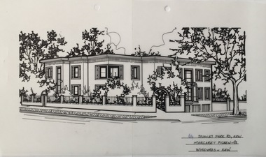
Drawing - Property Illustration, Margaret Picken, 64 Studley Park Road, Kew, 1993
After training as a Cartographic Draftsman within the mining industry, I worked as a property illustrator for real estate firms in the eastern suburbs of Melbourne for 22 years from 1983. I initially photographed houses with a Polaroid camera and made a 'thumbnail' sketch while there. The photos were used to scale off a sketch in pencil and then that sketch was overlaid with drafting film and the 'pen and ink' completed. The pens I used were the Rotring ‘Rapidigraph’ drafting pens. The ink was also made by Rotring (German).The film was ‘Rapidraw’, polyester drafting film, double matte. It takes a very fine line and doesn’t bleed. As well as house sketches, there were often floor plans and site plans ordered. Aerial sketches were ordered when the property needed an overall view. (Margaret Picken, 2020)This drawing is one of a series created by Margaret Picken for a number of real estate agents in Melbourne between 1983 and 2005. Each work is signed and dated by the artist.Gift of Margaret Picken, 2020Pen and ink architectural drawing on drafting film of 64 Studley Park Road, Kew by Margaret Picken.64 STUDLEY PARK RD., KEW / MARGARET PICKEN ~93 / WOODARDS ~ KEWartist -- margaret picken 1950-, architectural drawings -- houses -- kew (vic.), 64 studley park road - kew (vic) -
 Kew Historical Society Inc
Drawing - Property Illustration, Margaret Picken, 91 Studley Park Road, Kew, 1998
After training as a Cartographic Draftsman within the mining industry, I worked as a property illustrator for real estate firms in the eastern suburbs of Melbourne for 22 years from 1983. I initially photographed houses with a Polaroid camera and made a 'thumbnail' sketch while there. The photos were used to scale off a sketch in pencil and then that sketch was overlaid with drafting film and the 'pen and ink' completed. The pens I used were the Rotring ‘Rapidigraph’ drafting pens. The ink was also made by Rotring (German).The film was ‘Rapidraw’, polyester drafting film, double matte. It takes a very fine line and doesn’t bleed. As well as house sketches, there were often floor plans and site plans ordered. Aerial sketches were ordered when the property needed an overall view. (Margaret Picken, 2020)This drawing is one of a series created by Margaret Picken for a number of real estate agents in Melbourne between 1983 and 2005. Each work is signed and dated by the artist.Gift of Margaret Picken, 2020Pen and ink architectural drawing on drafting film of 91 Studley Park Road, Kew by Margaret Picken.91 STUDLEY PARK RD., KEW / MARGARET PICKEN ~98 / WOODARDS ~ HAWTHORNartist -- margaret picken 1950-, architectural drawings -- houses -- kew (vic.), 91 studley park road - kew (vic) -
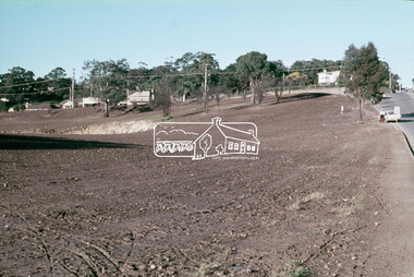 Eltham District Historical Society Inc
Slide, Construction of Eltham Town Park, 25 Jul 1973
Construction of Eltham Town Park; landscape has been scupltured and lakes formed. View looking up towards intersection of Bridge Street with Main Road. On the high side of Main Road is Garni Burges former home at the corner of Bridge Street then further to the left the former bakery on the corner of York Street. On the opposite corner is the feed store now the site of Le Pine Funerals. The park was later renamed Alistair Knox Park.35 mm colour positive transparency Mount - Agfacolor Service (Blue)Memorial Park 25 July 1973eltham, main road, alistair knox park, eltham town park, shillinglaw cottage, bridge street -
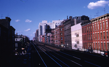
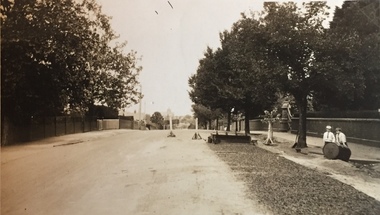 Kew Historical Society Inc
Photograph - Street Works, Studley Park Road, March 1934
Studley Park Road, like most streets in Kew, was originally a dirt road. Street works during the Great Depression included bituminising major roads in the district. This photograph of Council works originated in the City of Kew Engineers Department as a record of works undertaken. It was given to the collection by a Mrs Fisher in 1998.Well provenanced photograph of Council-funded public works in Kew during the Great Depression. Original sepia photographic positive of Studley Park Road, Kew while resurfacing of the street was taking place. The Kew Junction is just visible in the distance. Boys sitting on a drum at right. Behind them is the brick fence and front entrance to Tara Hall.Typed reverse: "B4 / Kew C.C. / Studley Park Road showing drag spread surfacing with premixed material, unrolled material on the right, March 1934"roadworks -- kew (vic.), street works -- kew (vic.), public works kew (vic.), studley park road -- kew (vic.), city of kew -- engineers department, city of kew -- public works -- great depression -- 1930s -
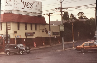 Kew Historical Society Inc
Photograph - Clifton Hotel, Kew Junction, 1994
Of the eight hotels established in Kew since European settlement, The Hotel Kew, known for most of its existence, as the Clifton Hotel was the seventh to be built in 1868. Its location on the corner of Studley Park Road and High Street at Kew Junction makes it a prominent landmark. Its current name is confusing for local historians as its main rival for the first 52 years was O'Shaughnessy's Hotel (1855), later renamed the Kew Hotel, on the corner of High Street and Denmark Street. Looking at the façade of the Hotel Kew, it is hard to imagine its mid-nineteenth appearance. There have probably been at least four renovations or rebuilding(s) of the structure. The documented renovations have occurred in the 1930s when the late Victorian façade was given an Art Deco update. In about 1970 its façade was again 'improved'. The many publicans who have held the licenses of the Clifton Hotel have been identified in in the 'Tetlow Index' and on the 'Boroondara Local History Wiki'. The most significant of these are Henry Madden (1880-87); Michael O'Donnell (1902-1920); and the Cronin-Ryan family (1935–53ff).Fading colour positive photograph of the Clifton Hotel at Kew Junction on the corner of High Street South and Studley Park Road. The hotel had been modified extensively over time, disguising the original Italianate facade. This is the colour scheme of the fourth restoration, including huge advertising billboards on the roof.Reverse: "Clifton Hotel. Studley Park Road at Kew Junction. 1994clifton hotel -- kew (vic.), hotels -- kew (vic.), kew junction -
 Glenelg Shire Council Cultural Collection
Photograph - Photograph - Casterton, Victoria, c. 1963
SOURCED FROM CASTERTON TOWN HALL (FORMER SHIRE OF GLENELG)Black and white photo. Island Park Casterton, looking across oval to C.R. Gill pavilion.Back: 'Island Park Casterton showing C.R. Gill Pavilion' - handwritten, green birocasterton -
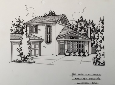 Kew Historical Society Inc
Drawing - Property Illustration, Margaret Picken, 2/42 Park Crescent, Kew, 1993
After training as a Cartographic Draftsman within the mining industry, I worked as a property illustrator for real estate firms in the eastern suburbs of Melbourne for 23 years from 1983. I initially photographed houses with a Polaroid camera and made a 'thumbnail' sketch while there. The photos were used to scale off a sketch in pencil and then that sketch was overlaid with drafting film and the 'pen and ink' completed. The pens I used were the Rotring ‘Rapidigraph’ drafting pens. The ink was also made by Rotring (German).The film was ‘Rapidraw’, polyester drafting film, double matte. It takes a very fine line and doesn’t bleed. As well as house sketches, there were often floor plans and site plans ordered. Aerial sketches were ordered when the property needed an overall view. (Margaret Picken, 2020)This drawing is one of a series created by Margaret Picken for real estate agents in Melbourne between 1983 and 2006. Each work is signed and dated by the artist.Gift of Margaret Picken, 2020Pen and ink drawing on drafting film of 2/42 Park Crescent, Kew, by Margaret Picken.2/42 PARK CRES., KEW EAST / MARGARET PICKEN ~93 / WOODARDS ~ KEWartist -- margaret picken 1950-, property illustrations — buildings — kew (vic.), 2/42 park crescent - kew (vic) -
 Lakes Entrance Historical Society
Photograph - Whiters Camp Park, Bulmer H D, 1940c
Black and white photograph showing rotunda with driveway in foreground, of Whiters Camp Park. Wind powered bore pump and tank stand in background. Lakes Entrance VictoriaThe Homestead Fringed in a Setting of Cypress, Whiters Camp Park.resort, recreation -
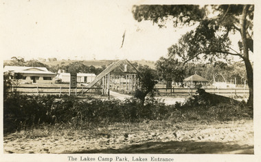 Lakes Entrance Historical Society
Postcard, Whiters Camp Park, 1928c
This is the before paired photograph used in the 150 year Lakes Entrance 1858-2008 display.|The after paired photograph number 02373.1|Also one 12 x 16 framed photograph used in room display.Black and white postcard of the Whiters Camp Park, showing entry from Roadknight Street. Homestead, picnic shelter, sign beside entry gives mileage to towns between Lakes Entrance and Melbourne. Lakes Entrance VictoriaThe Lakes Camp Park, Lakes Entranceresort, room display -
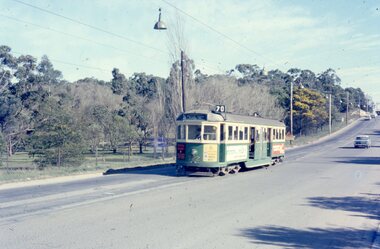 Melbourne Tram Museum
Photograph - Four colour slides - Wattle Park Single Line, Warren Doubleday, 1-8-1970
Set of four photographs taken at the time of the conversion of the Wattle Park route, in Riversdale Road from single line to double track between Warragul Road and the terminus, alongside Wattle Park itself. Yields information on the single line operation of the Wattle Park line prior the conversion to double track operation.Set of four colour Anscochrome slides, of single line operations on the Wattle Park line. .1 - W5 722 on Wattle Park single line, Sat. p.m. .2 - W2 388 meets W2 344 on Wattle park loop - shows the commencement of roadworks. .3 - SW5 853 from the park .4 - W5 738 at Warragul Road - shows the gates to Wattle park and the Caltex Service Station sign.Has photographers slide numbers on each slide.wattle park, route 70, riversdale rd, w2 class, w5 class, sw5 class, trackwork, tram 722, tram 388, tram 853, tram 738, trams, tramways -
 Kew Historical Society Inc
Drawing - Property Illustration, Margaret Picken, 3/47 Studley Park Road, Kew, 1990
After training as a Cartographic Draftsman within the mining industry, I worked as a property illustrator for real estate firms in the eastern suburbs of Melbourne for 22 years from 1983. I initially photographed houses with a Polaroid camera and made a 'thumbnail' sketch while there. The photos were used to scale off a sketch in pencil and then that sketch was overlaid with drafting film and the 'pen and ink' completed. The pens I used were the Rotring ‘Rapidigraph’ drafting pens. The ink was also made by Rotring (German).The film was ‘Rapidraw’, polyester drafting film, double matte. It takes a very fine line and doesn’t bleed. As well as house sketches, there were often floor plans and site plans ordered. Aerial sketches were ordered when the property needed an overall view. (Margaret Picken, 2020)This drawing is one of a series created by Margaret Picken for a number of real estate agents in Melbourne between 1983 and 2005. Each work is signed and dated by the artist.Gift of Margaret Picken, 2020Pen and ink architectural drawing on drafting film of 3/47 Studley Park Road, Kew by Margaret Picken.3/47 STUDLEY PARK RD., KEW / MARGARET PICKEN '90 / WOODARDS ~ artist -- margaret picken 1950-, architectural drawings -- houses -- kew (vic.), 3/47 studley park road - kew (vic) -
 Robin Boyd Foundation
Slide, Robin Boyd, 1956-1957
Robin Boyd developed a close friendship with the founder of the Bauhaus in Weimar Germany, Walter Gropius, who had moved to the USA in the 1930s. Through this connection, Boyd was invited to be the Massachusetts Institute of Technology (MIT) Bemis Professor at the School in the North American academic year 1956-7. Robin and Patricia Boyd, with their youngest daughter Suzy, were based in Cambridge, Massachusetts for the year. Boyd gave some lectures at MIT and he was also invited to give lectures at many other universities, allowing him to travel widely within the USA, especially on the East Coast. This gave him the opportunity to meet architects like Frank Lloyd Wright, Eero Saarinen, Paul Rudolph and many others, and visit the offices of Skidmore, Owings and Merrill, and places like Taliesin and the General Motors Technical Center Detroit. On the way home, the Boyds visited London, Berlin, Paris and Le Corbusier’s Ronchamp Chapel in France.Colour slide in a mount. Park Avenue, uptown Manhattan, New York, USAMade in USA / 13 / PARK AVE. UPTOWN / 24 (Handwritten) / Encircled 35F (Handwritten) / C46 (Handwritten)mit bemis professorship, mit, robin boyd, slide -
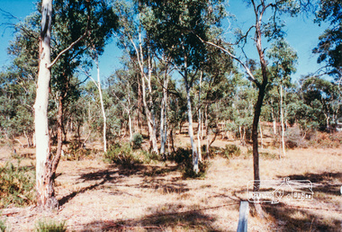 Eltham District Historical Society Inc
Photograph, Hohnes Reserve, Eltham Lower Park
... parks ...Colour photograph of bushland, Hohnes Reserve, Eltham Lower Parkeltham lower park, hohnes reserve, parks, bushland, hohnes road, eltham -
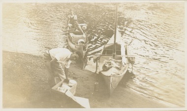 Kew Historical Society Inc
Photograph - Victorian Canoe Club, Xmas 1930, leaving Studley Park
Canoeing on the River Yarra at Melbourne was an important and widespread recreational pursuit for Melbournians, especially in the first half of the twentieth century. The Victorian Canoe Club was formed in 1912 at a meeting in Melbourne and its first committee elected in the same year. Records indicate that the Club continued into at least the 1950s .The photos in this album are historically and socially significant as a record of recreational activities in the first half of the twentieth century. A number of photographs in the album provide views of sections of the Yarra, as well as areas in regional Victoria, that may otherwise be unavailable.One of 12 sepia [faded] photographs of members of the Victorian Canoe Club. The first photo reveals three of the four club members leaving their clubhouse in Studley Park to travel downstream to the Lower Yarra and beyond to Port Phillip Bay. "Xmas 1930. Leaving Studley Park"victorian canoe club, river yarra, travel -- 1930s, canoeing -
University of Melbourne, Burnley Campus Archives
Booklet, Kenneth J. Polakowski, Marybyrnong Valley Metropolitan Park Master Development Plan, 1977
... parks ...parks, melbourne and metropolitan board of works, kenneth j polakowski, centre for environmental studies, university of melbourne -
Glenelg Shire Council Cultural Collection
Postcard - Postcard - Casterton, Victoria, 1960s
Sourced from Casterton Town Hall (former Shire of Glenelg)Postcard, black and white, Island Park, Casterton, showing football oval and pavilion, gum trees in backgroundFront: 'ISLAND PARK, CASTERTON, VIC', '4015' in bottom margin Back: Maker's stamptourism, travel, casterton -
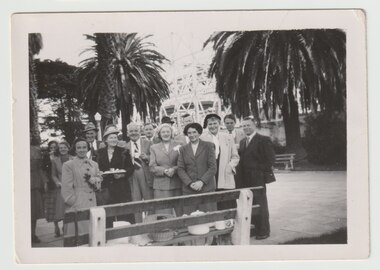 Melbourne Legacy
Photograph - Widows outing, Luna Park, 1952
Black and white photo x 4 of a group of Legacy widows at Luna Park in St Kilda, Melbourne. The legatees in the photos could be Morrie Tonkin, S Neville and Pat Hanna. Legatees looked after the widows and families of deceased ex-servicemen. Pat Hanna was a legatee who was an entertainer. It is unknown if the photos were posted from the UK or if the enveloped was reused.A record of outings and activities being provided for the widows.Black and white photo x 4 of widows at Luna Park in a brown envelope with airmail sticker and post mark from UK.Envelope has handwritten note 'Snapshots of widows at lawns outside Luna Park with Pat Hanna'. It is from the Ministry of Defence in Gloucester UK. Each photo has on back handwritten '1952/53' in blue pen and one has 'Legatee M Tonkin, S Nevile'widows, pat hanna, morrie tonkin -
 Bendigo Historical Society Inc.
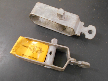
Tool - PITTOCK COLLECTION: TWO WIRE STRAINERS
Two steel wire strainers, one with makers tag noting Whites Wires Arndell Park NSW 2148; includes directions for application. Items stored in Pittock Coach builder's box, reference 13000.1.Whites Wires Arndell Park NSW 2148 -
 Port Melbourne Historical & Preservation Society
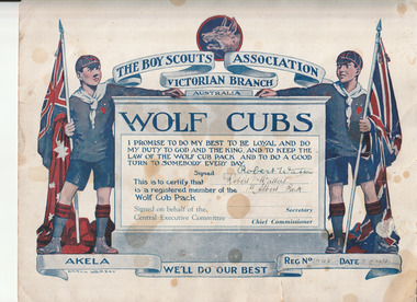
Certificate (Item) - The Boy Scouts' Certificate - Wolf Cubs, Victorian Education Department, 12 Sep 1931
Wolf Cub certificate presented to Robert WATTERS when joining the 1st Albert Park troop.Robert Watters, 1st Albert Park robert cornelius watters, club societies, 1st albert park wolf cubs -
 Marysville & District Historical Society
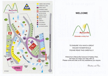
Flyer (Item) - Welcome flyer, WELCOME-Marysville Caravan & Holiday Park, Unknown
A welcome flyer for guests staying at the Marysville Caravan and Holiday Park that lists places to eat and local attractions to visit. Also shows a map of the caravan park.A welcome flyer for guests staying at the Marysville Caravan and Holiday Park that lists places to eat and local attractions to visit. Also shows a map of the caravan park.marysville, victoria, australia, marysville caravan & holiday park, welcome flyer -
Glenelg Shire Council Cultural Collection
Photograph - Photograph - Island Park Casterton, c. 1963
Sourced from Casterton Town Hall (Former Shire of Glenelg)Black and white photo, Island Park oval, Casterton, showing cycle track inside fence.Back: 'Island Park Oval. Cycle track shows inside fence', handwritten in green biro -
Whitehorse Historical Society Inc.
Pamphlet, Antonio Park, 1980?
Antonio Park: a valuable remnant of natural bush :Antonio Park: a valuable remnant of natural bush : leaflet for visitors including map and notes on the park's history, flora and fauna.Antonio Park: a valuable remnant of natural bush :antonio park, mitcham