Showing 232 items matching "princes pier"
-
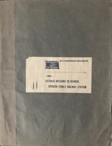 Mission to Seafarers Victoria
Book (Item) - Scrapbook, Edith E Hitchcock, Victoria Missions to Seamen, Spencer Street Railway Station, 1931-1943
... and the American ship: California State berthed in Prince's Pier. (plus two... and the American ship: California State berthed in Prince's Pier. (plus two ...The scrapbook, compiled by Edith E Hitchcock, displays a variety of newspaper clippings with photographs relating to ships, sailors, their hobbies, Padre Oliver. Page 1 - Map of the British Empire Page 3 - Newspaper clipping with photographs: "Happy Sailors Lads" onboard the CB Pedersen C.1935 Page 5 - Photograph depicting three children watching of a ship at sea Page 7 - 1937: article: with photograph"Sea Captain and Artist": Captain A.C.G. Dreillek, Swedish ship Yngaren (similar photo published in 1937 in the Courier Mail Brisbane) Page 9 - 1935: "Reunited": Dog Patsy with ship Pegasus crew members / "Sydney Harbour Bridge": Phillip Vanderhill, Cook of the Kota Inter and its sitar creation Page 11: Mr G. Gatty and Tim, the cat from the Esperance Bay / Herbert the hen, pet on the ship King Arthur / Frank Simpson, quartermaster and painter from the ship City of Dieppe. Page 13: Conway Seymour and shipmate aboard the Orford. Page 15: 3 photographs of French sailors from the cruiser Rigault de Grenouilly in 1936. Page 16: Photograph of A.J. Kramer working on a ship model aboard the Dutch ship, Kota Inten. Page 17: 1936: Photographs of sailors from the French ship Rigault de Grenouilly and the American ship: California State berthed in Prince's Pier. (plus two large loose clippings with portraits of same sailors). Page 18: 1934: Ball on the Manunda to raise funds for the Mission: photograph of Captain Robert Sunter, Padre Oliver, Moira Oliver, Mrs Harold Clapp. Page 19: Photograph of French sailors from the Rigault de Grenouilly in a bus en route to the Dandenong Ranges. Page 21: Photographs of a shipwreck (probably Kakariki in 1938, see next page). Page 23: Aerial photograph of the shipwreck Kakariki in Hobson's Bay in 1937 Page 25: Photograph of the shipwreck Kakariki in Hobson's Bay in 1937. Page 26: Photograph of the shipwreck Kakariki in Hobson's Bay in 1937. Page 27: Photograph of the survivors from the shipwreck Kakariki in the Mission in 1937: A. Bunyard, W. Fisk, J. Greene, L. Tarlington, J. McInnes, G. Coote, G. Sugar. Page 28: Photograph of the survivors from the shipwreck Kakariki in the Caradale in 1937: W. Fisk, T.W. White. Page 29: Missioneers talk to Firemen: Padre Oliver and his assistant, L.V. Owen talking to ship's firemen.(the Argus, 24 July 1931) Page 31: 3 articles with photographs: American cadets from the California State / Governor's Surprise Visit: Lord Huntingfield visiting Padre Oliver in the Mission (the Argus, 19 May 1936) / Sea Scouts on Liner: Padre Oliver on the P&O Cathay (the Argus, 16 June 1936) Page 33: Harbour Lights: padre Oliver, Lord Somers and Rev. R. Kerdell / Visit of the Duchess to the Mission (the Argus, 26 february 1945). Page 34: Photograph titled "An old salt still yearns for the sea- 369 miles away". Page 35: two clippings : Presentation of cheques for Merchant Navy: Betty Raymond giving a cheque to Padre L.L. Elliott / A cheque for the Seamen's Mission: Photograph of Padre Oliver with a cheque. Page 37: 4 clippings with photographs: Padre Oliver playing the piano for the cadets of the C.B. Pedersen / Miss Gladys Grant with parcels (from the Age 10 November 1943) / All Nations' Dance / Christmas at the Flinders Street mission, Padre Oliver cutting the cake (The Age, 15 December 1942) Page 39: Unveiling of the Memorial window to Captain Robert Sunter in 1936. Page 41: 2 clippings: At the Seamen's Mission: photographs of J. W. Neill and Padre Oliver / Married: Albert Robertson and Beryl Landrigan / Postcard of the St Peter Chapel. Page 43: 2 postcards: The Cloisters / The Mission view from Flinders Street. Page 45: Postcard of the windvane. / clipping of Sailors from the Zealandic. Page 46: 2 clippings: Virtually a Man without a country: Frans Nobel on the ship Milleeta / Seaman, Soldier, Waiter, Singer, Cook Finds Peace (Frans Nobel).(1939) Page 47: That Land Looks Good: two seamen from the tanker British Fame Page 48: large clipping of the C.B. Pedersen "Like a page from the past".(april-May 1935) Page 49: Photograph of Padre Oliver in his army uniform.This scrapbook is significant because it makes reference to contemporaneous events related to the Mission to Seafarers. On the inside cover is the name Edith E. Hitchcock.edith e. hitchcock, scrapbooks, c.b. pedersen, hobbies, ship models, painting, frank leslie oliver, mv manunda, captain robert sunter, windvane, rigault de genouilly, french, german, california, kakariki, ship pegasus, sydney harbour bridge, sugar, kota inten, philip vanderhill, lord somers, reverend r. kerdell, r.m.s. moldavia, victoria dock, ww2, pets, bird, dog, cat, gladys grant, alphonse polo, eugene emonin, raoul gannson, esperance bay, g. gatty, captain a. macwhirter, frank simpson, city of dieppe, conway seymour, orford, a.j. kramer, dutch, moira bird oliver (nee good), mrs harold clapp, caradale, 3uz radio, betty raymond, l.l. elliott, j.h. bustard, merchant navy patriotic fund, g.h. martin, j.w. neill, albert robertson, beryl landrigan, zealandic, frans nobel, milleeta, british fame -
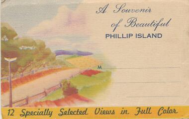 Phillip Island and District Historical Society Inc.
Postcard Folder, A Souvenir of Beautiful Phillip Island, 1920-30
Photograph Folder donated by Joe Prince.Colour Foldout photographs of Phillip Island. 1. Summerland Surf Beach 2. Thompson Avenue, Cowes 3. Cowes from the Pier 4. Fishing Fleet at San Remo 5. The Nobbies on south west end of Phillip Island 6. Koalas at home, Phillip Island 7. Erehwon Point, Cowes 8. Little Penguins at Summerland Beach 9. Isle of Wight Hotel, Cowes 10. The Nobbies and Blowhole 11. Bathing Beach, from the pier 12. The Newhaven to San Remo bridgeA Souvenir of Beautiful Phillip Island 12 specially selected views in full colour.cowes phillip island, wildlife - koala, the nobbies, the nobbies phillip island, newhaven - san remo bridge, summerland surf beach, thompson avenue, cowes, isle of wight hotel cowes phillip island, fishing fleet san remo, erehwon point, cowes, wildlife - penguins, joe prince -
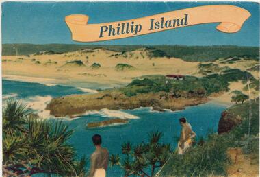 Phillip Island and District Historical Society Inc.
Postcard Folder, 1940 - 1950
Folder donated by Joe Prince. Inside folde as writtenr: "Phillip Island, Victoria, Australia" "Situated in Westernport Bay, Phillip Island offers a delightful combination of rugged coastal scenery, quiet restful countryside, and calm sheltered coves. The tourist finds ample interesting features within easy reach of the many Guest Houses and Hotels. The native Koala Bear is seen in numerous parts of the island, and tourist parties are given the opportunity of visiting the haunts of the Penguin and Seal. Excellent beaches provide good swimming and surfing, and the sportsman finds plenty of scope for his activities. The new bridge from San Remo to Newhaven provides an alternative means of communication to that supplied by the Ferry from Stony Point to Cowes." Colour photo folder of Phillip Island. 1. The picturesque rugged coastline at Phillip Island 2. Isle of Wight Hotel, Cowes, Phillip Island 3. The Nobbies and Seal Rocks, Phillip Island 4. Summerland Beach, the home of the Fairy Penguins, Phillip Island (now called Little Penguins) 5. Overlooking the Jetty at Cowes, Phillip Island 6. View from the Jetty looking towards Cowes 7. The Australian Koala and young 8. Thompson Avenue, Cowes 9. One of the many fine beaches at Phillip Island 10. Coastal scene from Erehwon Point, Phillip Island 11. Seals on the Seal Rocks, off Phillip Island 12. The Parade of the Fairy Penguins, Phillip Island 13. Fishing craft at San RemoOn front: "Phillip Island"coastline phillip island, wildlife - koala, wildlife - penguins, wildlife - seals, cowes jetty, cowes pier phillip island, isle of wight hotel - cowes phillip island, fishing boats, the nobbies phillip island, seal rocks phillip island, seals on seal rocks phillip island, joe prince, thompson avenue, cowes -
 4th/19th Prince of Wales's Light Horse Regiment Unit History Room
Stereographic Photographs, Rose, George, Victorian Contingent. S.S.Medic Leaving the Pier, c. 1900
Albumem silver stereographs. The transport is pulling away from the pier. There is a crowd of onlookersThe titleboer war, victorian contingent -
4th/19th Prince of Wales's Light Horse Regiment Unit History Room
Stereographic Photographs, Victorian Contingent. S.S.Medic Leaving the Pier, c. 1900
Albumem silver stereograph. Shows SS Medic pulling away from the pier. A crowd is watchingThe titleboer war, victorian contingent -
Port Melbourne Historical & Preservation Society
Book, Richard Broome, Remembering Melbourne 1850-1960, 2016
"Remembering Melbourne 1850-1960". Large red covered book with black and white dust cover featuring panoramic view of Princes Bridge looking North. Photographs and text covering Melbourne CBD and 20 suburbs including Port Melbourne.Royal Historical Society Victoria (RHSV) bookplate signed by Don Garden and Richard Broome.built environment, business and traders, centenary bridge, piers and wharves - railway pier, sport, industry, religion - anglican (holy trinity), swallow & ariell ltd, sandridge lagoon, melbourne air service, joshua brothers distillery, robert harper & co ltd, faram brothers hardware, j kitchen & sons pty ltd, courthouse, police station, north port oval, missions to seamen, commonwealth engine works -
Port Melbourne Historical & Preservation Society
Postcard - Spirit of Tasmania, Tasmanian Ferry, c. 1993
Found at Hazel Wilson's house (78 Princes Street) when things were being removed after she went into a nursing home. Postcard was sent to Mrs Wilson on 23.5.1995 from her friends Lila and RayPostcard of Spirit of Tasmania, sent to a Port Melbourne address in 1995. Image of ship loaded at Station PierMessage on back, postmark, stamppiers and wharves - station pier, transport - ferries, hazel trembath wilson, spirit of tasmania -
Port Melbourne Historical & Preservation Society
Photograph - Aerial view of cruise ships at Port Melbourne piers, 13 Feb 2001
This photograph records the concurrent visit to Station Pier of three cruise ships - the peak of the Cruising Victoria strategy aimed at encouraging cruise shipping to Melbourne. Also the Devil Cat was berthed at Station Pier on this day but not in the photo (4 ships in one day)Aerial colour photograph taken by The Age, showing from left to right, cruise ships Regal Princess, QE2 and Silver Cloud, all at Station Pier on 13 February 2001. An unusual persective showing the rear of 'The Anchorage', formerly Swallow and Ariell, also Stokes and Princes Streetspiers and wharves - station pier, transport - shipping, rms queen elizabeth 2, qe2, swallow & ariell ltd, regal princess, silver cloud -
Port Melbourne Historical & Preservation Society
Document - 2014 Calendar, Pat Grainger, Historic Port Melbourne - Hotels, Sep 2013
Researched, written and designed by member Pat GRAINGER as a fundraiser for PMH&PS. 2014 PMHPS calendar ; Hotels. Cover shows Bay St from the North west showing Scott's Hotel and the National Bank of Australasia All following years calendars also recorded against cat no 1864built environment - commercial, business and traders - hotels, piers and wharves, sport - australian rules football, natural environment - beaches and foreshore, port melbourne historical & preservation society, pmhps, scott's hotel, lamb's hotel, chusan hotel, royal mail hotel, exchange hotel, united states hotel, t thomas, chequers inn, bay and boundary hotel, freemasons hotel, donaldson, peter gallienne grut, whithorn and son, foresters arms hotel, flower hotel, boundary rovers football club, wilbraham frederick evelyn liardet, pier hotel, london family hotel, prince alfred hotel -
Port Melbourne Historical & Preservation Society
Document - List of Port Melbourne Hotels & Licencees 1872, 1872
Handwritten list of hotels & their licencees in 1872 believed to have been complied by donor's ancestor, a member of the LOBB family.A4 size handwritten sheet with names, addresses and licencees of Port Melbourne hotels in 1872.business and traders - hotels, built environment - commercial, lobb, h. fonseca, harry hall, william hays, j mcculloch, wm reynolds, g sefton, mrs crockford, andrea lagogiannis, g braithwaite, v sanderson, j carter, g w hall, j michie, t cowling, jas. bartlett, edward suffolk, martin clasby, mrs peatt, w kinyon, william spire, thomas turville, w cruickshank, charles peacock, j williams, william cannon, j bell, michael flanagan, william carroll, j w carr, john allen, j e crockford, charles sharp, henry o'brien, g t potter, f johnson, all england eleven hotel, army & navy hotel, auld reekie hotel, australian hotel, bay view hotel, brunswick pier hotel, chequers inn, chusan hotel, commercial hotel, cosmopolitan hotel, customs house hotel, exchange hotel, fitzjames hotel, floodgate hotel, foresters arms hotel, foundry hotel, fountain inn, freemasons hotel, happy home hotel, hibernian hotel, kent hotel, locomotive hotel, lord raglan hotel, marine hotel, naval brigade hotel, new great britain hotel, pier hotel, president lincoln hotel, prince alfred hotel, retreat inn, royal hotel, ship hotel, station hotel, victoria hotel -
Port Melbourne Historical & Preservation Society
Photograph - Demolition of Centenary Bridge, 1991
... Tasman Station Pier Gatehouse Princes Street Twenty One (21 ...Twenty One (21) colour photographs of demolition of Centenary Bridge and redevelopment of Station Pier to create roll on/roll off facility for Bass Strait ferries.piers and wharves - station pier, engineering - bridges, centenary bridge, abel tasman, station pier gatehouse, princes street -
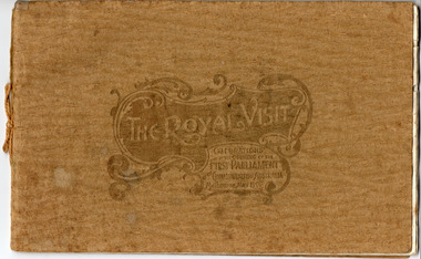 St Kilda Historical Society
Memorabilia - Booklet, The Royal Visit Celebrations at the Opening of the First Parliament Commonwealth of Australia Melbourne May 1901, 1901
Booklet contains photographs of: THH the Duke and Duchess of Cornwall and York; Earl of Hopetoun, Governor General, and Countess; Commonwealth Ministry; The Royal Party at Government House Melbourne; TRH the Duke and Duchess Landing at St Kilda Pier; The Mayor of Melbourne Welcoming His Royal Highness at the entrance to the City; Procession Passing down Bourke Street; Presentation of War Medals to Victorian Soldiers; The Duke of York and his Staff; St Kilda and Prahran Arch; City Arch; Procession passing Princes Bridge; Opening Ceremony at First Federal Parliament; Citizens' Arch; Queen Victoria Arch; Royal Yacht Ophir; Warships Gromoboi (Russian) and Brooklyn (USA); German Arch; Chinese Arch; State School Fete at Exhibition Building; The University Commencement; Group of Fijian Constabulary; Laying Foundation Stone, Soldiers' Memorial Ballarat; Visit to South Star Gold Mine, Ballarat; Illuminations at Princes Bridge and Flinders Street Station; Illuminations at Parliament House and Treasury; Illuminations at Town Hall and City ArchGold coloured paper cover embossed and tied with gold thread. Contains 16 pages of cream coloured paper printed in black, some with blue decorative margins.Handwritten inscription on title page: 'For the Boy from Grandfather in memory of a very happy time we spent together May 1901'duke and duchess of cornwall and york, royal visits, 1901, opening of parliament, federation arch, st kilda and prahran arch, city arch, german arch, chinese arch -
 St Kilda Historical Society
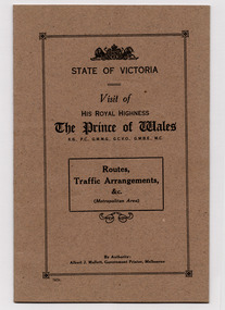
Administrative record - Booklet, Visit of His Royal Highness The Prince of Wales - Routes, Traffic Arrangements &c, 1920
Routes and traffic arrangements for the visit to Victoria on 26 May - 7 June 1920 by the Prince of Wales (later King Edward VIII). The visit was to officially thank Australia for the support to Great Britain during World War I and to strengthen the links between Australia and the Empire. The booklet details the routes, escorts, and traffic arrangements, starting with the procession from St Kilda Pier to Federal Government House on his arrival on 26 May.Multi-page booklet of white pages with a brown card cover and bound with two staples. Printed in black.royal visits, prince of wales -
 St Kilda Historical Society
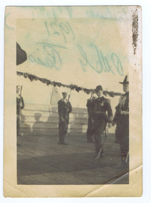
Photograph, St Kilda Pier, c. 1921
St Kilda Pier at the time of visit of HRH Prince Edward of Wales 1921black and white photograph, unmounted, original, poor conditionOn back: St Kilda Pier at the time of visit of HRH Prince Edward of Wales 1921. Presented by C Kelly 14-2-82 -
 City of Ballarat
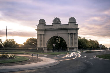
Public Artwork, Arch of Victory Monument, 1920
A grand cement rendered masonry structure of a single central arch flanked by wide piers 20metres in width, spanning the roadway, and 18 metres high. Crowned by the 'Rising Sun' symbol of the Australian Commonwealth Military Forces beneath which the words Avenue of Honour and Victory are written prominently across the arch. Erected in 1920, the Arch marks the beginning of s 22 kilometre stretch of 3728 trees, each one a memorial to men and women in order of enlistment for World War 1. On 2 June 1920, the Prince of Wales opened the Arch and was presented with a pair of silk pyjamas embroidered with Australian emblems. Each of the 500 'Lucas Girls' had put in a stich. The Arch of Victory, located at the entrance to the Avenue of Honour Ballarat, was erected in 1920 as a memorial to the people of the Ballarat and the surrounding district who enlisted in World War I. The Avenue of Honour, with the Arch of Victory, was officially opened by the Prince of Wales on 3rd June 1920. The single central arch is flanked by wide piers 20 metres in width, spanning the roadway, and 18metres high. The monument is of historical significance to the people of BallaratCement rendered masonry arch structureCrowned by the 'Rising Sun' symbol of the Australian Commonwealth Military Forces beneath which the words Avenue of Honour and Victory are written prominently across the arch.arch of victory, avenue of honour ballarat, australian commonwealth military forces, world war i, prince of wales, lucas girls -
Port Melbourne Historical & Preservation Society
Photograph - Photographic copy, Sketch of the Duke arrivng at Town Pier, Sandridge, Illustrated Australasian News, c. 1869
NB the date of this and the fact that the hotels shown were there in 1868-9 suggests this isn't the Duke of Edinburgh - he arrived late in 1867, at Railway Pier, and stayed quite a few months in Australia, but would he have been at Town Pier in 1869?Photographic copy of sketch of the Duke (Prince Alfred, Duke of Edinburgh?) arriving at Town Pier, Sandridge' (Illustrated Aust. News 22.3.1869 p.59) shows Bell's Pier Hotel and Scott's Royal Hotelnumber 53 on back with some detail until pasted paperpiers and wharves - town pier, transport - shipping -
Port Melbourne Historical & Preservation Society
Audio - Oral History, Sylvia Gleeson, 29 May 1991
Interviewed by Pat Grainger at Sylvia's home at 98 Princes Street. Interview used in contributions to the book "They Can Carry Me Out" .Sylvia Gleeson discussing her life in Port Melbourne, particularly in relation to the operation of the kiosk on the East Wing Pier of Station PierDuration 01:03:07families, domestic life, piers and wharves - station pier, business and traders - kiosk, sylvia gleeson -
 Lakes Entrance Historical Society
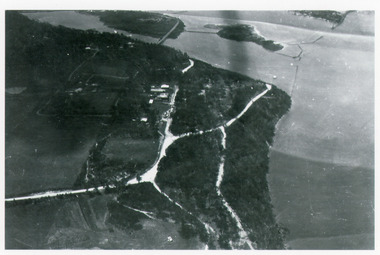
Photograph - Kalimna, Bulmer H D, 1940c
Black and white photograph of aerial view of Kalimna escarpment, Princes Highway, road to Kalimna Hotel, scattering of buildings including Gainsborough House, in distance is North Arm bridge, footbridge to undeveloped Bullock Island with rock groynes in place. Part of eastern pier of entrance at Lakes Entrance, Victoria. waterways, topography, township, bridges -
 Eltham District Historical Society Inc
Photograph - Digital Photograph, Alan King, Eltham Railway Trestle Bridge, 28 December 2007
Covered under National Trust of Australia (Victoria) State Significance and Heritage Overlay, Nillumbik Planning Scheme. Published: Nillumbik Now and Then / Marguerite Marshall 2008; photographs Alan King with Marguerite Marshall.; p103 The Eltham railway trestle bridge is the only one of its kind still regularly used in Melbourne’s metropolitan railway network. Opened in 1902, it is also one of Victoria’s very few timber rail bridges that still carries trains.1 The bridge is part of the railway line extension from Heidelberg - extended to Hurstbridge in 1912. This extension resulted in one of the greatest social changes experienced in Eltham Shire, as it considerably lessened its isolation attracting tourists, artists and suburban commuters particularly after World War Two.2 The bridge has been classified by the National Trust as historically, scientifically, aesthetically and socially significant at state level. But this has not always been recognised, and in 1977, locals fought to save it from destruction. The Victorian Railways proposed to replace the bridge with an earth embankment and large culverts to avoid maintenance problems and fire. This was rejected by the Eltham Council who protested that the bridge helped maintain the area’s rural character, historic link and beauty, as well as avoiding possible serious flooding on the flood plain if a culvert was blocked. The bridge stands as part of a National Trust classified landscape which includes the Alistair Knox Park, named after the local conservationist and architect who helped to make Eltham famous for its mud-brick houses. The landscape includes tall and spreading manna gums and candlebarks, and the historic Shillinglaw Cottage. Artist Walter Withers, one of the Heidelberg School of painters, painted the bridge early in the 20th century. The 38 span single-track railway bridge over creek and road has 34 timber-beam spans and four steel-joist spans, supported by four-pile timber piers and timber abutments. It has almost 200m of timber deck. All of the timbers have been replaced over the years, but the only change to the bridge’s character was the addition of pylons and wiring for electric trains in 1923. A petition for a railway to the shire was first made in 1883. A large deputation of local citizens to the Commissioner of Railways proposed a route passing through Alphington to midway between Greensborough and Eltham up the Diamond Creek valley towards Queenstown and Kinglake. As a result the Princes Bridge-Heidelberg Railway was opened in 1888. From 1888 locals demanded a railway extension. Kangaroo Ground farmers in particular, led by Shire Councillor and Member for Evelyn, Ewen Cameron, said it would assist local farmers and orchardists send their produce to the Melbourne market. In 1890, before the severe economic Depression, an extension of the line to Hurst’s Bridge (now Hurstbridge) was included in a new Railways Bill. The parliamentary delegations were regaled with a banquet at Hurst’s barn and entertained by the Diamond Creek Brass Band, but the extension was abandoned when the Depression struck in 1892-1893. The extension of the railway to Eltham, completed in 1902, was one of the few built in those hard times. That is why the Eltham timber-trestle railway bridge is a rare example of a broad-gauge rail bridge constructed between 1893 and 1910. At the opening, despite persistent drizzle, 300 children waving flags and banners were among the large crowd welcoming the first train, carrying official dignitaries, to Eltham. It had taken 24 years to bring the railway to Eltham. From then Eltham became a popular destination for outings. Mr Orford of Eltham recalled that after the railway came to Eltham ‘the craze for picnics on weekends and holidays began…. During the wattle season, wattle trains came to Eltham frequently. The visitors roamed the creek pulling great armfuls of wattle blossom to take back with them to Melbourne’.3 In 1926 the railway line was electrified as part of the metropolitan rail network. But the Victorian Railways decided not to complete the formerly planned Diamond Valley Railway to Queenstown (now St Andrews) and Kinglake.This collection of almost 130 photos about places and people within the Shire of Nillumbik, an urban and rural municipality in Melbourne's north, contributes to an understanding of the history of the Shire. Published in 2008 immediately prior to the Black Saturday bushfires of February 7, 2009, it documents sites that were impacted, and in some cases destroyed by the fires. It includes photographs taken especially for the publication, creating a unique time capsule representing the Shire in the early 21st century. It remains the most recent comprehenesive publication devoted to the Shire's history connecting local residents to the past. nillumbik now and then (marshall-king) collection, eltham railway trestle bridge, eltham trestle bridge -
 Lakes Entrance Historical Society
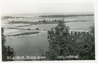
Postcard - Bullock Island, The Lakes Studio, 1920c
One black and white copy 17 x 25Black and white postcard showing North Arm Bridge, Bullock Island and foot bridge northern end of piers at entrance to Bass Strait and sand dunes. Left foreground shows power pole and water bore and telephone poles along Princes Highway Lakes Entrance Victoria.The Entrance, Bullock Island, Lakes Entranceislands, bridges, waterways, topography -
 Lakes Entrance Historical Society
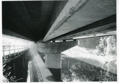
Photograph - Bridges, Lakes Post Newspaper, 1991
This photo appeared in the Lakes Post Newpaper 24 July 1991Black and white photograph looking under the decking of the new Princes Highway concrete bridge over Toorloo Arm, showing the support pier shaped to fit the camber of the curved bridge. Timber bridge in left of image still in use. Toorloo Arm Victoriabridges, construction -
Port Melbourne Historical & Preservation Society
Photograph - Foreshore, Port Melbourne
... - Station Pier Natural Environment - Beaches and Foreshore Princes ...See cat nos 3354, 3355, 3359, 3361, 3362Black and white photographs, taken from Station Pier, each showing part of Centenary Bridge and Eastwards along the foreshore. Taken Sunday 4 February 1962piers and wharves - station pier, natural environment - beaches and foreshore, princes street drain jetty, piers and wharves - miscellaneous, swallow & ariell ltd, john harper & sons, centenary bridge, engineering - bridges