Showing 634 items matching "river view"
-
 Eltham District Historical Society Inc
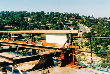
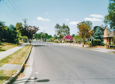
Photograph, Southeast view from new bridge over Plenty River looking along Plenty River Drive, Greensborough Bypass construction, c.1986, 1986c
Mura Close and Tangari Court visible on left, Warriparri Crescent on right of Plenty River Drive.Colour photograph originally located in a magnetic style album titled 'Greensborough Bypass 1990s 5' suffering significant degradation. No information contained in album or on reverse of photos except where noted. Relocated to archival photosafe storage.greensborough bypass, road construction, greensborough, mura close, tangari crescent, plenty river drive, warriparri crescent -
 Eltham District Historical Society Inc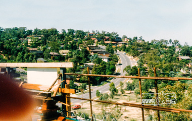
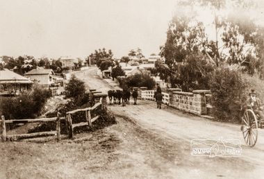
Photograph, Main Street, Greensborough, c.1900, 1900c
Shows view looking up Main Street, Greensborough across the Plenty River BridgePhotograph copy originally located in a magnetic style album titled 'Greensborough Bypass 1990s 5' suffering significant degradation. No information contained in album or on reverse of photos except where noted. Relocated to archival photosafe storage.greensborough, main street, plenty river bridge -
 Eltham District Historical Society Inc
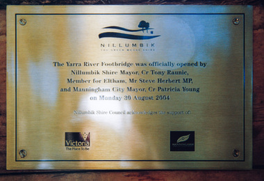
Photograph, Doug Orford, Completion of bridge works across Yarra River at rear of Eltham Lower Park, August 2004
... lovely views over the Yarra River.... lovely views over the Yarra River. bridges yarra river eltham ...Plaque commemorating the opening of the Yarra River Footbridge opened by Nillumbik Shire Mayor Cr. Tony Ranuic, Member for Eltham, Mr Steve Herbert MP, and Manningham City Mayor, Cr. Patricia Young on Monday 30 August 2004. Nillumbik Shire Couuncil acknowledges the support of the Victorian State Government and City of Manningham. The footbridge links the Diamond Creek Trail between the Shire of Nillumbik and City of Manningham. It is a shared pathway and also links with the Main Yarra Trail. It affords lovely views over the Yarra River.One of three colour photographsbridges, yarra river, eltham south, eltham lower park, lenister farm, homestead road, plaque, yarra river footbridge, steve herbert, tony ranic, patricia young -
 Eltham District Historical Society Inc
Photograph, Doug Orford, Mountain View Road, Briar Hill, near River Street, 1991, 1991
From a collection of 35 photos taken by Doug Orford at 35 specific locations along the exact boundary of the then Shire of Eltham.Colour photographbriar hill, mountain view road -
 Eltham District Historical Society Inc
Photograph, Doug Orford, Completion of bridge works across Yarra River at rear of Eltham Lower Park, July 2004
... lovely views over the Yarra River..... It affords lovely views over the Yarra River. bridges yarra river ...Bitumen shared pathway under construction at the new Eltham-Templestowe footbridge over the Yarra River off Homestead Road, Eltham which was completed in July 2004. The Yarra River Footbridge was opened in August 2004 and links the Diamond Creek Trail between the Shire of Nillumbik and City of Manningham. It is a shared pathway and also links with the Main Yarra Trail. It affords lovely views over the Yarra River.Three colour photographs showing commencement of construction of Eltham-Templestowe footbridge over Yarra River off Homestead Road, Eltham which was completed July 2004. Third photograph of dedictaion plaque at opening 30 Aug 2004bridges, yarra river, eltham south, eltham lower park, lenister farm, homestead road, asphaldt, bitumen, shared pathway, diamond creek trail -
 Eltham District Historical Society Inc
Photograph, Pedestrian suspension bridge over the Yarra River at Lower Plenty, 18 Apr 1998, 1998
Lower Plenty Heritage Excursion included the former monastery of the Blessed Sacrament Fathers, now Odyssey House, and its suspension footbridge across the Yarra River. Odyssey House drug rehabilitation centre in Bonds Road, Lower Plenty is a distinctive landmark, especially when viewed from across the Yarra at Templestowe. It was built in the 1950’s as a seminary for the Blessed Sacrament Fathers. Because of the poor and circuitous road access, a suspension footbridge was built across the river. As well as providing easy access for the priests residents of Templestowe could attend services at the seminary. The bridge is now part of the Yarra Trails system.Roll of 35mm colour negative film, 6 strips Also photographic prints 10 x 15 cmKodak Gold 200-6activities, blessed sacrament fathers, bonds road, bridge, foot bridge, lower plenty, odyssey house, seminary, yarra river -
 Eltham District Historical Society Inc
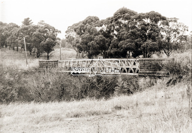
Photograph, Monash Bridge, Arthurs Creek Road, Hurstbridge, Eltham Heritage Tour, 24 May 1992, 24/05/1992
ELTHAM HERITAGE TOUR The Society excursion on 24th May 1992 was arranged by David Bick, leader of the team carrying out the Shire's heritage study. David selected a number of sites or buildings identified in the study, some of them lesser known components of the Shire's heritage. The tour commenced at the Eltham Shire Office at 10.00 am. Travel was by private car and mini-bus with stops at about twelve locations for commentary by David.It included a short walk in Hurstbridge and lunch at Kinglake. Highlights of the tour included: - 10 am Leave from Shire Offices - 3 Important Trees - A Physical Link to Eltham's First Settlers - Toorak Mansion Gates - A Surviving Farm House - An Intact Circa 1900 Main Street - First Settlers - Gold Miners, and Timber-getters - An Early Hotel - A Pioneering Homestead - Changing Eltham Shire - 20th Century - 4 pm Afternoon Tea and Finish Tour Extract from ELTHAM CULTURAL HERITAGE TOUR (Newsletter No. 85, July 1992, by Bettina Woodburn) "On the Arthurs Creek Road is a bridge designed by Monash, which we admired before walking across the little park with a mud-brick and timber shelter, to the Hurst family graveyard. There are two marked graves, one, Henry who was shot by Burke the bushranger and a cairn has a plaque listing others buried here from 1866 onwards. Burke was captured and tied to the wheel of a dray under the eucalypt near the waterhose/standpipe. Close by the kindergarten, at this place are three trees on the National Trust Register, a Canary Island pine, a Canadian cedar and probably a spruce. Radiata pines and a thick bolled peppercorn surround the little cemetery. Continuing along Main Street we notice elm trees planted as a war memorial, then on the left a 1930 timber house, a 1910 store and residence, resplendent with wrought iron trim, a double fronted Hardware Store and cypresses on the back alignment of a new vacant block. On the right side of the street is a less interesting attempt at an 'in character' shop. Further on are more early homes, one tucked away at the rear with two tall palms by the front steps. Another curiosity is a rounded veranda corner and there are more galvanised iron sheds or garages, before a mud-brick Dentist's Surgery. Beyond the round-a-about is St Peters Church, of mud-brick construction shared by Catholic and Anglican parishioners, overlooking the river flood plain. Leaving Hurstbridge on the Kinglake Road, we ate our picnic lunch beside the communication tower and enjoyed views of Melbourne, Yan Yean Reservoir and the distant Dandenongs beyond the spreading suburbs. Next we drove to the North West boundary of the Shire at Masons Falls Road towards Whittlesea. On the way to the North East Boundary we passed St Peters, a yellow wooden Church with a Tudor Archway; built in the early 1920's in the style of the 1860's. From the Healesville-Kinglake road the rolling hills had European aspects, the hedged fields and chestnut trees. Then it was back down the Hurstbridge Road through 'Aussie' bush of towering gums, with bracken and scrubby understorey, the Kinglake National Park, before more open country with deciduous trees planted in line, and a creek lined with willows."Record of the Society's history and activities and highlighting various aspects of the Heritage Study undertaken by David Bick used to create the future heritage overlay for the Shire of Eltham and later Nillumbik Shire.Roll of 35mm colour negative film, 4 stripsKodak Gold 100 5095shire of eltham historical society, activities, heritage tour, hurstbridge, monash bridge, arthurs creek road -
 Eltham District Historical Society Inc
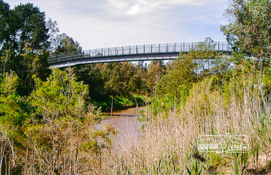
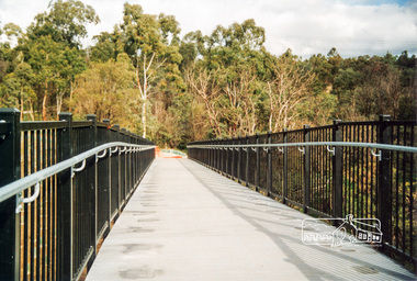
Photograph, Footbridge across the Yarra River at Eltham Lower Park
... with the Main Yarra Trail. It affords lovely views over the Yarra River.... with the Main Yarra Trail. It affords lovely views over the Yarra River ...The Yarra River Footbridge was opened in August 2004 and links the Diamond Creek Trail between the Shire of Nillumbik and City of Manningham. It is a shared pathway and also links with the Main Yarra Trail. It affords lovely views over the Yarra River.Colour photographbridge, eltham lower park, eltham south, homestead road, lenister farm, yarra river, footbridge, lookout, diamond creek trail -
 Eltham District Historical Society Inc
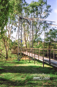
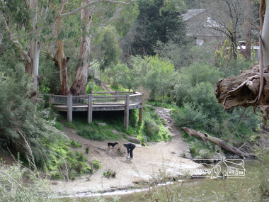
Photograph, Liz Pidgeon, Heritage Excursion; Eltham Lower Park Walk and Talk, 1 July 2017, 1 July 2017
Connecting trunks of gum trees near the viewing platform on the Diamond Creek. Newsletter No., 234, June 2017 Heritage Excursion - Saturday 1st July - Eltham Lower Park - Walk and Talk Eltham Lower Park has played an important part in the history of our area since the early days of European settlement when it was used by local residents as an informal racecourse. Prior to that its location at the junction of the Diamond Creek and the Yarra River made it an important meeting place for the Wurundjeri people. The park combines formal elements and sporting facilities with remnant bushland that is of environmental significance. It is home to sporting and horse riding clubs, popular play spaces and the Diamond Valley Miniature Railway, which attracts large numbers of visitors. The park will be the venue for our July excursion which will comprise a walk of about 3.5 km around the park and adjacent areas. Along the way we will discuss the history and natural history of the area. The path along the creek and the river provides a pleasant and scenic walk. This walk on Saturday 1st July is about 3.5 km in length and will take 2 to 2.5 hours. It will start at 2pm at the Main Road car park at the front of the park. (Melway ref 21 H 10). Born Digitalheritage excursion, activities, eltham district historical society, eltham lower park, gum trees -
 Eltham District Historical Society Inc
Photograph, Liz Pidgeon, Heritage Excursion; Maroondah Aqueduct, 3 September 2016, 3 September 2016
View of Diamond Creek Newsletter No., 229, August 2016 Heritage Excursion - Maroondah Aqueduct Walk - Saturday 3rd September The Maroondah Aqueduct was once a major link in Melbourne’s water supply system. It was built between 1886 and 1891 to transfer water from the Watts River near Healesville to the Preston Reservoir. It was 66 km in length, made up of 41 km of open channel, 10 km of tunnel through hills and 15 km of pipeline across stream valleys known as inverted siphons. The section of the aqueduct through the Eltham area has been abandoned since the 1980s but the open channel has largely been retained. A recreational path follows the aqueduct reserve. For our excursion on 3rd September we intend to walk along the section of the aqueduct adjacent to Allendale Road. This is a section not visited on previous excursions and includes the transition from open channel to the inverted siphon across the Diamond Creek valley. Apart from the aqueduct itself the main feature of the walk is the extensive views across Eltham North and Diamond Creek. Along the way we will talk about the history of the aqueduct and the area. This easy walk is about 3 km return and will take 2 to 2.5 hours. It will start at 2pm at the junction of Allendale Road with Godber Road and Zig Zag Road North, officially Diamond Creek, but on the northern boundary of Eltham. (Melway ref.12 B10). Born Digitalmaroondah aqueduct, eltham north, activities, eltham district historical society, heritage excursion, diamond creek, acqueduct trail -
 Eltham District Historical Society Inc
Photograph, Liz Pidgeon, View from Candlebark Park across the Yarra to the confluence of the Diamond Creek and Yarra River at Lennister Farm, 16 July 2017, 16 July 2017
Born Digitaleltham, candlebark park, yarra river, diamond creek, lennister farm -
 Kiewa Valley Historical Society
Photos - Tawonga Bridge x 2
The first Tawonga bridge was built in 1884. It was destroyed by floods in 1916. The new bridge was constructed in 1923 and destroyed in 1953. The present concrete bridge was constructed in 1986 and named Ryders Bridge. Also refer to ?KVHS 0962 and KVHS 1051, KVHS 1090, KVHS 1123Bridge constructed over the Kiewa River in 1923 and destroyed in 1953.1. Dark Brownish photo framed by thin wood. Photo shows bridge with mountain behind and river and river bank in the foreground. 2. Small photo showing 2 sides of the bridge - a close up view.tawonga bridge, kiewa valley, kiewa river -
 Kiewa Valley Historical Society
Photograph of Kiewa Valley Panorama, Kiewa Valley from No. 5 Road, Before 1945
In 1943 a camp for workmen was erected and a commencement made with the erection of plant storage and workshop buildings in the new township of Mt. Beauty. The photograph was probably taken after the completion of these buildings. There is no sign of construction of the town itself. In the latter part of 1945 work was commenced on the Mt. Beauty township area with a medical centre, general trading store and some houses under construction. The No. 5 Road, from where the photograph was taken, is the road to West Kiewa Power Station and Big Hill Scenic Lookout.Is an excellent view of the Kiewa Valley before there was little work undertaken to establish the town of Mt. Beauty. Farming was well established with the evidence of huge areas of cleared land. The junction of the East and West Kiewa Rivers can be clearly seen. The first Workmen's camp is near the river and some workshop buildings can also be seen. Black and white photograph of the Kiewa Valley, looking North.Handwritten on the back of photograph "Kiewa Valley from No. 5 Road".kiewa valley, camp, buildings, mt. beauty -
 Eltham District Historical Society Inc
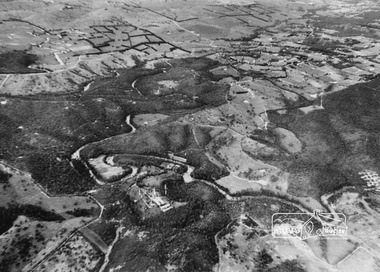
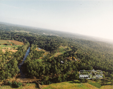
Photograph, Aerial view of Yarra River near Kangaroo Ground - Bend of Islands area
... Aerial view of Yarra River near Kangaroo Ground - Bend of...Sepia aerial view of Yarra river at Bend of Islands; Henley... Sepia aerial view of Yarra river at Bend of Islands; Henley Road ...Sepia aerial view of Yarra river at Bend of Islands; Henley Road on left in foregroundbend of isles, kangaroo ground, yarra river, henley road -
 Eltham District Historical Society Inc
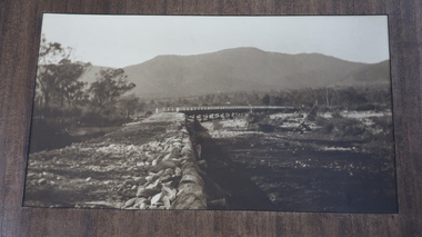
Photograph, Old Lower Plenty Bridge, c.1970
... collections as well as several recent views. main road plenty river ...Old bridge across the Plenty River at Lower Plenty now part of the Plenty River Trail. Part of a slide show presentation "Bridges & Waterways of the Shire" by Russell Yeoman to the 13 September 1989 Society meeting. The presentation included slides of historic photos from the Shire of Eltham Pioneers collections as well as several recent views.Black and white photographmain road, plenty river, bridge, lower plenty, plenty river trail -
 Eltham District Historical Society Inc
Photograph, Sweeneys Lane looking southwest, Dec 1984, 198412
Two colour photographs of view south across Sweeneys flats and Yarra River, Sweeneys Lane, Elthamsweeneys lane, yarra river, eltham, thomas sweeney, culla hill -
 Eltham District Historical Society Inc
Photograph, Yarra River, Sweeneys flats, 1994c
Colour photogrpah of oblique aerial view looking east over Yarra River and Sweeneys flats c.1994sweeneys lane, yarra river, culla hill, thomas sweeney, aerial photographs -
 Eltham District Historical Society Inc
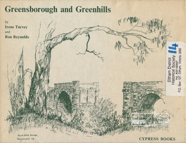
Book, Irene Turvey et al, Greensborough and Greenhills / words by Irene Turvey ; Drawings by Ron Reynolds, 1973
Pen and ink sketches accompanied by appropriate text in double page spreads. Contents cover : Blue stone bridge, Introduction, House cnr Church and Hailes Street, House - 25 Hailes Street, Yandell Reserve, Greensborough Hotel, Lobb's Kiosk, House - 49 Grimshaw Street, View of Greensborough (from Delphin Crescent), Railway Station, Old Barn (near Greensborough Railway Station), Partington's Flat and River Valley, Rand Street Bridge, Lower Main Street, Greenbriar Nursery, Hitching rail, Ashmead - Dr Cordner's Home, Greensborough Primary School, House - cnr St Helena and Diamond Creek Raods, Sondermeyer's Hill, Methodist Church, Football Pavilion, Cemetery, St Katherine's Church, St. Helena, Civic Centre, Briar Hill Timber Mill, 24 River Street, Kelly's Garden Supplies, 158 Main Street, Old Swimming pool, 105 Main Street.Hardback; 62 p. : ill., map ; 19 x 25 cm.ISBN 0909807108 Signed by author and illustrator Two copiesgreenhills, greensborough -
 Eltham District Historical Society Inc
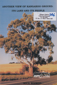
Book, Mick Woiwod, Another view of Kangaroo Ground : its land & its people / Mick Woiwod, 2009
Paperback; 54 p. : ill. (some col.), maps, port ; 30 cm.Inscribed and signed by Author wurundjeri, social customs, place names, yarra river, environment, kangaroo ground, culture, aborigines -
 Eltham District Historical Society Inc
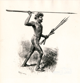
Photograph, Sketch of Aboriginal man with spears by W. Macleod
... , inasmuch as he has furnished posterity with many view of towns..., inasmuch as he has furnished posterity with many view of towns ...This black and white image appears on page 9 "Painters and Pioneers: One hundred years of Eltham and its Shire" by Alan Marshall (1971). (It is incorrectly acknowledged as S.T. Gill in the acknowledgements). It relates to Chapter 1 "The Beginning" and the description of explorer's Joseph Gellibrand journey through the area (and beyond) of the area now known as Eltham and wider Shire of Nillumbik. Gellibrand was accompanied by male aborigines. William Macleod (1850-1929) was a contributor to the "Picturesque Atlas of Australia" 1886. Described in "The Daily Telegraph" 21 June 1924 :"Macleod is a preserver of the scenic records of his own time, inasmuch as he has furnished posterity with many view of towns, rivers, and other localities, as they appeared in the years 1886-8. Among these, he has given us ...a blackfellow throwing a spear...' Image first published 1886. Image re-published in "Painters and Pioneers", 1971 pioneers and painters, aborigine, spear, drawing, william macleod, picturesque atlas of australia, aboriginal australian -
 Eltham District Historical Society Inc
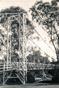
Photograph, Pedestrian suspension bridge over the Yarra River at Lower Plenty
Odyssey House drug rehabilitation centre in Bonds Road, Lower Plenty is a distinctive landmark, especially when viewed from across the Yarra at Templestowe. It was built in the 1950’s as a seminary for the Blessed Sacrament Fathers. Because of the poor and circuitous road access, a suspension footbridge was built across the river. As well as providing easy access for the priests residents of Templestowe could attend services at the seminary. The bridge is now part of the Yarra Trails system.Two black and white photographs of footbridge over Yarra River, part of the Ruffey Trail just off the Main Yarra Trail near the former seminary (now Odyssey House) Lower Plentybridges, yarra river, odyssey house, bonds road, lower plenty, seminary, blessed sacrament fathers -
 Eltham District Historical Society Inc
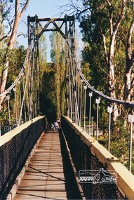
Photograph, Pedestrian suspension bridge over the Yarra River at Lower Plenty
Odyssey House drug rehabilitation centre in Bonds Road, Lower Plenty is a distinctive landmark, especially when viewed from across the Yarra at Templestowe. It was built in the 1950’s as a seminary for the Blessed Sacrament Fathers. Because of the poor and circuitous road access, a suspension footbridge was built across the river. As well as providing easy access for the priests residents of Templestowe could attend services at the seminary. The bridge is now part of the Yarra Trails system.Colour photograph of footbridge over Yarra River, part of the Ruffey Trail just off the Main Yarra Trail near the former seminary (now Odyssey House) Lower Plentybridges, yarra river, lower plenty, seminary, blessed sacrament fathers, odyssey house, bonds road -
 Eltham District Historical Society Inc
Photograph, Doug Orford, Completion of bridge works across Yarra River at rear of Eltham Lower Park, July 2004, July 2004
... with the Main Yarra Trail. It affords lovely views over the Yarra River.... with the Main Yarra Trail. It affords lovely views over the Yarra River ...Brand new Eltham-Templestowe footbridge over the Yarra River off Homestead Road, Eltham which was completed in July 2004. The Yarra River Footbridge was opened in August 2004 and links the Diamond Creek Trail between the Shire of Nillumbik and City of Manningham. It is a shared pathway and also links with the Main Yarra Trail. It affords lovely views over the Yarra River.One of three colour photographs.yarra river, eltham south, eltham lower park, lenister farm, homestead road, shared pathway, diamond creek trail, footbridge -
 Warrnambool and District Historical Society Inc.
Postcard - Views of Warrnambool
Pictures depicting scenes of Warrnambool & District. 9 pictures are, The Beach. Hopkins River. Thunder Point. Liebig St. Botanical Gardens. Breakwater and pier. Hopkins River. Soldiers Memorial. Hopkins Falls.A typical souvenir postcard from the 1930'sOblong postcard with flip down views of Warrnambool from a purse with two kittensValentine's Mail Novelty Post Card; Good Luck And a Bagful of Views from WARRNAMBOOLwarrnambool, hopkins river, warrnambool breakwater, warrnambool postcards, postcards, hopkins falls, thunder point, soldiers memorial -
 Warrnambool and District Historical Society Inc.
Souvenir - Post Card 12 views of Warrnambool, Nucolorvue Productions, 1950's
This type of folded postcards was popular with tourists in the 1940s, 50s, and 60s and often kept by them for many years afterwards. The views of Warrnambool here, taken about the 1950s, were typical of the Warrnambool postcards available at the time and were mass-produced as many examples survive today. They include photographs of Hopkins Falls, the beach and harbour, Liebig Street, Hopkins River, coastal scenery and the Botanical Gardens. These postcards are of some historical interest, though the photographs appear frequently in many publications. They also have a social significance showing what tourists bought 60 or more years ago.This is a packet in envelope form containing 12 coloured postcards of views of Warrnambool about the 1950s. The photographs are printed on buff-coloured paper and fold up to envelope size so that they can be sent by post. The front cover includes three dotted lines for the address and the back cover has a space to include the name of the sender. One page gives some general information on Warrnambool. Front cover: ‘A Souvenir of Beautiful Warrnambool’, ’12 Specially Selected Views in Full Color’ Back cover: ‘From…’ , ‘Published by Nucolorvue Productions, Elwood, Victoria’ tourism, warrnambool -
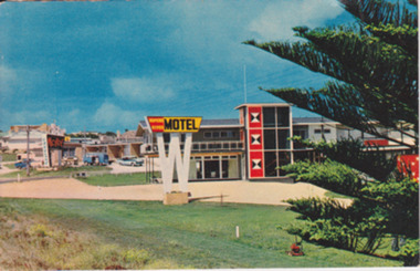 Warrnambool and District Historical Society Inc.
Postcard - Post Card Warrnambool Motels, Circa 1960’s
These two motels were built in the 1960’s on the eastern outskirts of Warrnambool on the corner of the old Princes Highway and Simpson St. They were both built around 1960. The Turn In was originally known as Freeland’s Turn In. The Hopkins River, later the Riverside Motel, was demolished in around 2000. This photograph provides a view of Warrnambool as it was beginning the expansion on the East side of Warrnambool. The buildings depicted are very typical of the style of buildings of the 1960.s Coloured photograph postcard depicting the Hopkins River Motel. Large red and yellow sign mounted on top of a white ‘W’ Part of Norfolk pine. The back is unused. Nucolorvue productions Pty Ltd. W4. Printed in Australia. Printed in Australia. warrnambool, freeland’s turn in, hopkins river motel, turn in motel, warrnambool motels -
 Warrnambool and District Historical Society Inc.
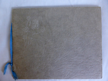
Album - Views of Warrnambool
The album contains postcards (photographs). The photographs (postcards) of Warrnambool and district in the 1930s/40s include views of the Botanic Gardens, the coast line, the main streets, the War Memorial and Hopkins Falls. The postcards from the 1890s include Wilmot, the Hopkins River, Hopkins Falls and Shelly Beach.The postcards in the album are in good condition and will be useful for reproduction. The 1930s/40s collection of photographs (also postcards) is a useful one also and a good example of how people preserved mementoes of their visit to a town. All the photographs are contained in other collections or albums held elsewhere in the Historical Society collection.This is a photograph album of ten pages with a buff-coloured cover of thickened card with a raised surface and an embossed image of a woman in the left corner of the front page. There are five postcards attached to the inside covers and 31 other photographs (postcards) in the slots provided. One photograph is missing from these slots. Embossed ornately decorated image of a woman on the front cover. postcards and photographs, warrnambool 1930s/1940s -
 Eltham District Historical Society Inc
Negative - Photograph, Warrandyte Bridge over River Yarra, c.1910
View of the 1875 timber trestle bridge over the Yarra River reproduced from a newsprint image. Also known as Anderson's Creek (Road) Bridge A contract was accepted for William Elliot to erect a bridge over the Yarra River at Warrandyte on Anderson's Creek Road and other improvements for £1,331.6.2 - Gazette No. 143. Tuesday, November 13th 1860 - http://gazette.slv.vic.gov.au/view.cgi?year=1860&class=general&page_num=2161&state=V&classNum=G143&id=). The bridge was washed away by floods in 1863. It was replaced with a taller timber trestle structure in October 1875, designed and built by C.S. Wingrove, Shire Clerk, Engineer and Surveyor for Eltham Shire Council. A replacement for this bridge was commenced in 1955 to cope with increasing traffic and this structure was widened in 2018 to meet further traffic demands. Argus (Melbourne, Vic. : 1848 - 1957), Thursday 23 September 1875, page 7 ________________________________________ THE WARRANDYTE BRIDGE. The ceremony of formally opening the newly erected bridge over the Yarra at Ander-son's Creek was performed on Monday last, in the presence of the members of the Eltham and Bulleen shire councils whose territories it joins, and a goodly number of the residents of the district. The task was delegated to Mr. Cameron, M.L.A., who, after a few introductory remarks declared the bridge to be opened, and christened it the " Warrandyte Bridge." The party then adjourned to Grant's Hotel, where a cold collation had been prepared. The chair was taken by the president of the Eltham shire (Mr. John Bell) and the vice chair by Mr. Kent, a member of the Bulleen council. Mr Robert Williamson proposed "Success to the bridge," coupling with it the name of Mr. Cameron, to whose exertions was in the main to be attributed the erection of that structure which was an ornament to the district and would prove of great service to both sides of the river. Mr. Cameron, in responding, alluded to the great difficulties, mainly of a pecuniary nature, that had been encountered in carrying out the project, and which had only been got over by their united efforts and by the liberal spirit in which the late Commissioner of Roads had dealt with the case. The healths of the contractor and the engineer were also drunk. The bridge is a trussed timber one, resting on yellow box piles sunk into the solid rock, each pier being weighted with 50 tons of stone. The abutments consist of dry stone walls, 6ft. thick at the base, and tapering to 3ft. on the top, the face of the work having a batter of 1 to 1. The length of the bridge is 308ft., there being four openings in the centre of 66ft. each, and two at the ends of 20ft. each. The width in the clear is 9½ft., and the height from the bed of the river about 33ft. The approaches comprise 1,100 cubic yards of earthwork, and the formation of 48 chains of sideling, the whole cost of the work, which was carried out under the direction of the engineer to the Eltham Shire Council, being £1,413.This photo forms part of a collection of photographs gathered by the Shire of Eltham for their centenary project book,"Pioneers and Painters: 100 years of the Shire of Eltham" by Alan Marshall (1971). The collection of over 500 images is held in partnership between Eltham District Historical Society and Yarra Plenty Regional Library (Eltham Library) and is now formally known as the 'The Shire of Eltham Pioneers Photograph Collection.' It is significant in being the first community sourced collection representing the places and people of the Shire's first one hundred years.Digital image 4 x 5 inch B&W Neg B&W Print 12.5 x 9 cmsepp, shire of eltham pioneers photograph collection, warrandyte, bridge