Showing 575 items
matching road construction building
-
 Eltham District Historical Society Inc
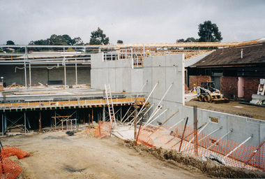
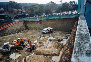
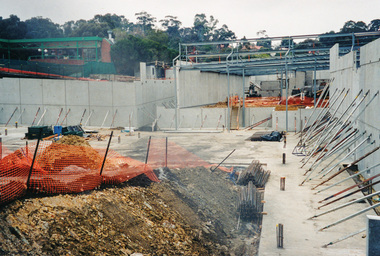
Photograph, Ruth H. Pendavingh, Building of the new Coles store at the corner of Main Road and Arthur Street, Eltham, 1999, 1999
Four colour photographs showing construction of the Coles store in Arthur streeteltham, coles store, arthur street, construction, buildings -
 Eltham District Historical Society Inc
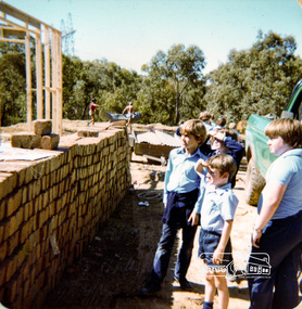
Photograph, Excursion to Fields house next to school early in year, Eltham Christian School, 1982, 1982
... photograph. eltham christian school nyora road buildings construction ...Excursion to Fields family house under construction next to school early in year, Eltham Christian School, 1982. From a series of photographs (some cropped) from a magnetic photo album relating to the staff, students and activities of the Eltham Christian School which operated as part of the Eltham Christian Church at Nyora Road, Eltham. See also entries for each photograph.3 colour photographseltham christian school, nyora road, buildings, construction, field house -
 Eltham District Historical Society Inc
Photograph, Liz Pidgeon, Heritage Excursion; The 1901 Eltham Railway Walk, 3 May 2014, 3 May 2014
Newsletter No. 216, May 2014 May Excursion – The 1901 Eltham Railway Walk The railway from Heidelberg to Eltham was opened in 1902. Over the previous year railway construction cut a curving swathe through Josiah Holloway’s 1851 Little Eltham subdivision. The survey plans for the railway show the owners and occupiers of land within Little Eltham affected by the railway alignment and for some distance each side. The plans show houses and other buildings but development at that time was rather sparse. Copies of these plans from the State Library of Victoria collection have been provided to the Society by Alan Sheehan. For our walk on 3rd May we intend to follow the railway from the Eltham Station to Ryans Road, which was the boundary of the adjoining Montmorency Farm. The return will be by way of nearby streets. Along the way we will discuss the details shown on the railway plans as well as more recent railway documents and photographs. At the conclusion and if time permits we can inspect the historical display at the Eltham Station. The walk is about 3 km in length and will take about 2.5 hours. It will start at 2 pm at the Eltham Railway Station car park (east/Main Road side) (Melway Ref. 21 J5).Born Digitalheritage excursion, activities, eltham district historical society, eltham railway station, eltham library, trestle bridge -
 Eltham District Historical Society Inc
Photograph, Liz Pidgeon, Heritage Excursion; The 1901 Eltham Railway Walk, 3 May 2014, 3 May 2014
Football match at Eltham Central Park between Eltham and Heidelberg Newsletter No. 216, May 2014 May Excursion – The 1901 Eltham Railway Walk The railway from Heidelberg to Eltham was opened in 1902. Over the previous year railway construction cut a curving swathe through Josiah Holloway’s 1851 Little Eltham subdivision. The survey plans for the railway show the owners and occupiers of land within Little Eltham affected by the railway alignment and for some distance each side. The plans show houses and other buildings but development at that time was rather sparse. Copies of these plans from the State Library of Victoria collection have been provided to the Society by Alan Sheehan. For our walk on 3rd May we intend to follow the railway from the Eltham Station to Ryans Road, which was the boundary of the adjoining Montmorency Farm. The return will be by way of nearby streets. Along the way we will discuss the details shown on the railway plans as well as more recent railway documents and photographs. At the conclusion and if time permits we can inspect the historical display at the Eltham Station. The walk is about 3 km in length and will take about 2.5 hours. It will start at 2 pm at the Eltham Railway Station car park (east/Main Road side) (Melway Ref. 21 J5).Born Digitalheritage excursion, activities, eltham district historical society, eltham railway station, eltham library, trestle bridge, eltham central park, football -
 Eltham District Historical Society Inc
Photograph, Liz Pidgeon, Heritage Excursion; The 1901 Eltham Railway Walk, 3 May 2014, 3 May 2014
Newsletter No. 216, May 2014 May Excursion – The 1901 Eltham Railway Walk The railway from Heidelberg to Eltham was opened in 1902. Over the previous year railway construction cut a curving swathe through Josiah Holloway’s 1851 Little Eltham subdivision. The survey plans for the railway show the owners and occupiers of land within Little Eltham affected by the railway alignment and for some distance each side. The plans show houses and other buildings but development at that time was rather sparse. Copies of these plans from the State Library of Victoria collection have been provided to the Society by Alan Sheehan. For our walk on 3rd May we intend to follow the railway from the Eltham Station to Ryans Road, which was the boundary of the adjoining Montmorency Farm. The return will be by way of nearby streets. Along the way we will discuss the details shown on the railway plans as well as more recent railway documents and photographs. At the conclusion and if time permits we can inspect the historical display at the Eltham Station. The walk is about 3 km in length and will take about 2.5 hours. It will start at 2 pm at the Eltham Railway Station car park (east/Main Road side) (Melway Ref. 21 J5).Born Digitalheritage excursion, activities, eltham district historical society, eltham railway station, eltham library, trestle bridge -
 Eltham District Historical Society Inc
Photograph, Liz Pidgeon, Heritage Excursion; The 1901 Eltham Railway Walk, 3 May 2014, 3 May 2014
EDHS Member Doug Orford stands by a yarn bombing installation. ewsletter No. 216, May 2014 May Excursion – The 1901 Eltham Railway Walk The railway from Heidelberg to Eltham was opened in 1902. Over the previous year railway construction cut a curving swathe through Josiah Holloway’s 1851 Little Eltham subdivision. The survey plans for the railway show the owners and occupiers of land within Little Eltham affected by the railway alignment and for some distance each side. The plans show houses and other buildings but development at that time was rather sparse. Copies of these plans from the State Library of Victoria collection have been provided to the Society by Alan Sheehan. For our walk on 3rd May we intend to follow the railway from the Eltham Station to Ryans Road, which was the boundary of the adjoining Montmorency Farm. The return will be by way of nearby streets. Along the way we will discuss the details shown on the railway plans as well as more recent railway documents and photographs. At the conclusion and if time permits we can inspect the historical display at the Eltham Station. The walk is about 3 km in length and will take about 2.5 hours. It will start at 2 pm at the Eltham Railway Station car park (east/Main Road side) (Melway Ref. 21 J5).Born Digitalheritage excursion, activities, eltham district historical society, eltham railway station, eltham library, trestle bridge, yarn bombing, doug orford -
 Eltham District Historical Society Inc
Photograph, Liz Pidgeon, Heritage Excursion; The 1901 Eltham Railway Walk, 3 May 2014, 3 May 2014
Newsletter No. 216, May 2014 May Excursion – The 1901 Eltham Railway Walk The railway from Heidelberg to Eltham was opened in 1902. Over the previous year railway construction cut a curving swathe through Josiah Holloway’s 1851 Little Eltham subdivision. The survey plans for the railway show the owners and occupiers of land within Little Eltham affected by the railway alignment and for some distance each side. The plans show houses and other buildings but development at that time was rather sparse. Copies of these plans from the State Library of Victoria collection have been provided to the Society by Alan Sheehan. For our walk on 3rd May we intend to follow the railway from the Eltham Station to Ryans Road, which was the boundary of the adjoining Montmorency Farm. The return will be by way of nearby streets. Along the way we will discuss the details shown on the railway plans as well as more recent railway documents and photographs. At the conclusion and if time permits we can inspect the historical display at the Eltham Station. The walk is about 3 km in length and will take about 2.5 hours. It will start at 2 pm at the Eltham Railway Station car park (east/Main Road side) (Melway Ref. 21 J5).Born Digitalheritage excursion, activities, eltham district historical society, eltham railway station, eltham library, trestle bridge -
 Kiewa Valley Historical Society
Photo: Making of Kiewa Valley Highway at Tawonga
The Kiewa Valley Highway was/is a major road along the Kiewa River ending at Mt Beauty the site of the S.E.C.V. town built for the construction of the K.H.E.S.Black and white photo with roofless old car beside two horses pulling a cart with man behind the cart. All coming towards the photographer on a road with paddocks on each side.kiewa valley highway, road building -
 Kiewa Valley Historical Society
Photos - King Family Collection
The King family lived in Tawonga South where my older brother and sister went to school. We lived over the road from Wally Madison's farm. Later when a house became available, we moved into Valley Avenue, Mt Beauty. This is when I turned 5 and started my schooling. It was a long walk for a 5 year old as I remember. Then later we moved to 50 Lakeside Ave. I remember we loved living there as it was close to the school, footy ground and kindergarten. My father, Ted King, wad a carpenter and was involved in the building of many houses in Mt Beauty which was the home for the workers on the Kiewa Electric Scheme. So as they are part of the history of Mt Beauty I thought they may be useful to you as part of the history. The tennis photos, I vaguely remember Lou Hoad and Ken Rosewell giving exhibition matches in Mt Beauty. I may stand corrected on this, but I do remember my parents who were keen tennis players themselves were most excited at seeing these famous tennis players. As I was only 9 when we left Mt Beauty to live in Dimboola I still remember the shock of leaving a beautiful mountainous county side and arriving in a flat farming land next to a desert and seeing windmills One thing I do remember from school is, once a week (or fortnight) the teacher used to come around with a jar of little white pills, of which we were all to take. I really don't know what they were?? or for?? I also remember being taught to swim in the freezing cold river by a Mrs Smith who wore black bathers and wore her hair in a bun...... ...I am now in my 70s My father used to also carve intricate trays and jewellery boxes in his spare time. I think they were used for tennis trophies. by Diane Werner.x33 photos of small black and white photos of the Tawonga, Tawonga South and Mt Beauty - Photos not labelled but described as follows. See each photo for a possible label. A. Tawonga? B. Mt Beauty taken on the road to Bogong ? C. SEC Works D. Industrial buildings with mountains in the background E. Building site with wooden frame and 3 men F. Buildings with power poles G. Building site with lots of huts H. Buildings under construction I. Group of houses in the distance J. Group of houses in the distance K. Group of people in front of a building L. Group of 8 men sitting on timber planks, corrugated iron at back. M.& N. Building site with floor and upright timbers O. Mountain view with camp site in foreground P.& Q. Buiding site, several houses R.5 men at a building site S. portable building on trailer T & U. Mountain view V. Building site W. Group of men, car and mountains in background X. Cows Y. Pigs Z. 2 men standing next to cars. AA. Football players BB. Man painting a corrugated iron building CC. Football DD. Men in front of a building EE Buildings with mountains in background FF & GG Tennis payersHH & II. Electricity infrastructure -
 Kiewa Valley Historical Society
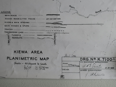
Map - Kiewa Area Planimetric Map
Planimetric maps are two-dimensional representations of the Earth's surface, showing the location and spatial arrangement of features such as roads, buildings, and bodies of water.A very clear map showing the Kiewa Hydro Electric Scheme in two dimensions to include the construction done by the SECV.Black and white Map of the Kiewa Area from Mt Beauty to the High Plains covering the Kiewa Hydro Electric Scheme and surrounds. Drawn on 11th May 1966kiewa hydro electric scheme 1966 -
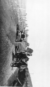
 Kiewa Valley Historical Society
Photograph of Kiewa Valley Panorama, Kiewa Valley from No. 5 Road, Before 1945
In 1943 a camp for workmen was erected and a commencement made with the erection of plant storage and workshop buildings in the new township of Mt. Beauty. The photograph was probably taken after the completion of these buildings. There is no sign of construction of the town itself. In the latter part of 1945 work was commenced on the Mt. Beauty township area with a medical centre, general trading store and some houses under construction. The No. 5 Road, from where the photograph was taken, is the road to West Kiewa Power Station and Big Hill Scenic Lookout.Is an excellent view of the Kiewa Valley before there was little work undertaken to establish the town of Mt. Beauty. Farming was well established with the evidence of huge areas of cleared land. The junction of the East and West Kiewa Rivers can be clearly seen. The first Workmen's camp is near the river and some workshop buildings can also be seen. Black and white photograph of the Kiewa Valley, looking North.Handwritten on the back of photograph "Kiewa Valley from No. 5 Road".kiewa valley, camp, buildings, mt. beauty -
 Kiewa Valley Historical Society
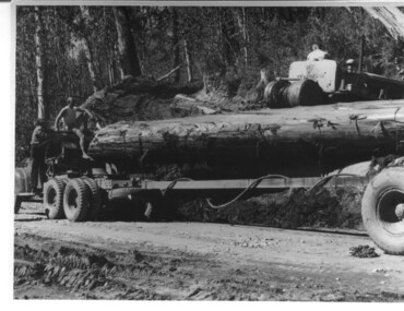
Photograph, logging at McKay Creek, Logging at McKay Creek, 1949/50
This photo was most likely taken at the site of the proposed McKay Creek Power Station. Excavation of this site was commenced in 1951 but an access road (a rough, narrow track) was put it in 1948 and widened in 1954. The State Electricity Commission would have milled logs from this area at their mill at Howman's Gap. The timber was used for building of housing and camps and provided a much needed resource as there was a general shortage of this commodity. The power station was relocated underground owing to repeated problems with landslides in the area. Restricted financial resources and the repositioning of the power station retarded construction activities and it was not completed until early 1961. An historical pictorial record of the type of machinery used in the 1950's - logging truck with bogie attached, the bull dozer and winch for hauling logs to the truck and note the lack of protective clothing!Black and white photograph showing a logging truck, bogie and bull dozer with winch for hauling the logs to the truck. Two men are on the truck, a driver on the bull dozer and a large log on the bogie. Hand written on the back of photo "Logging at McKay Creek".logging, mckay creek, timber, machinery