Showing 19805 items
matching shipwrecked-coast
-
 Lakes Entrance Historical Society
Book, Discovery of Bass Straight and Shipwrecks
A folder of information on discovery of Bass Strait and other information on shipwrecks including the Sydney Cove Victoriashipwrecks, waterways -
 Phillip Island and District Historical Society Inc.
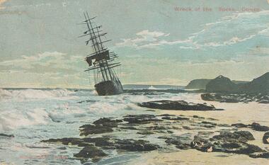
Photograph - Post Card, 1906
One of a collection of photographs donated by Shirley Peterson.Colour postcard of the wreck of the :Speke" on the south coast of Phillip Island in 1906."Wreck of the "Speke", Cowes" "Robb Bros. Cowes"wreck of the sailing ship "speke", phillip island coastline, phillip island, shirley peterson -
 Phillip Island and District Historical Society Inc.
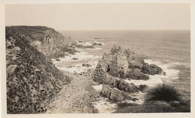
Photograph, Unknown
One of 6 photograph donated by M. BattyBlack & White photograph of South Coast of Phillip Island with rocky outcrop.phillip island coastline, coastline - south coast, rocky outcrock phillip island, phillip island, m batty -
 Bendigo Historical Society Inc.
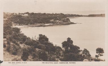
Postcard - THE BEAUTIFUL COAST MORNINGTON ,VIC
The Beautiful Coast Mornington, Vic. To Florrie from Ada on their''Lovelly holiday''. -
 Robin Boyd Foundation
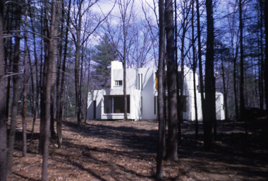
Slide, Robin Boyd, 1971
Colour slide in a mount. Unknown building, probably east coast USAMade in Australia / 15 / AUG 71M1slide, robin boyd -
 Orbost & District Historical Society
black and white photograph, late 19th century - early 20th century
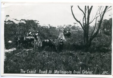
Prior to the sealing of the Princes Highway west of Orbost, the road surface was anything but good, even by C1917 when cars started to use the road. From Orbost the old road via Marlo to Sydenham was abandoned for the new location which traversed more rugged country via Cabbage Tree, Bell Bird and Club Terrace to Cann River, and the reason for this diversion was on account of settlements being established at Murrungowar and Club Terrace, at which latter place there was a temporary rush to obtain gold. This road was constructed by the Public Works department and a maximum grade of 1 in 19 was adopted, and as speed was not to be catered for the grade followed in and out round the spurs and gullies, resulting in a maze of turns and twists which required a good deal of skill on the part of the horse driver to negotiate." - Bairnsdale Advertiser, Friday, May 2, 1947. (More information from Newsletter February 2010)n the late 1800's early 1900's transporting goods by road was difficult and at times impossible because roads as thoroughfares did not exist.The means of travelling along the roads in the 1800's was by bullock wagon, horse pulled dray, pack horse or simply by foot. This road is still in use in East Gippsland as a part of many four-wheel-drive touring routes.A large black / white photograph of two horse - drawn wagons on a narrow sandy bush track. It is surrounded by scrub. There is one man standing beside a horse not harnessed to a wagon.on front - "The Coast Road to Mallacoota from Orbost JPC" -
 Warrnambool and District Historical Society Inc.
Document - South West Coast Piper Drummer Dancer 2014, 2014
This item advertises a performance by the Warrnambool & District Pipes & Drums in 2014. Many sponsors were gained. The Warrnambool Pipe Band was established in 1906. It went into recess from 1916 to 1835 when it was re-formed. Today it performs under the name of Warrnambool & District Pipes & Drums in the area.This item is of minor significance as a memento of the Warrnambool & District Pipes & Drums A page advertising a performance by the Warrnambool & District Pipes and Drums. It contains sixteen logos in colour including that of the Warrnambool and District Pipes and Drums . South West Coast Piper Drummer Dancer 2014warrnambool & district pipes and drums, wadpadi, south west coast piper drummer dancer -
Glenelg Shire Council Cultural Collection
Souvenir - Pen, n.d
Pen, biro, blue/black marbled, gold trims, gold lettering on cap.Front: 'Portland Coast Region Water Authority' - gold -
 Queenscliffe Maritime Museum
Poster - Safety at Sea Poster
Poster published by the Department of Transport , Communication, Federal sea Safety and Surveillance CentreSafety at sea InitiativePoster depicting a reproduction of 'The Shipwreck' by JMW Turner with the heading 'Let's make the next 200 years safer' poster, public awareness, safety at sea, turner, 'the shipwreck' -
 Phillip Island and District Historical Society Inc.
Photograph, The Speke, 22/02/1906
The Speke was an all steel ship of 310 feet, beam of 35 feet and weight of 2,712 tons and triple masted. She was built in 1891 at Carnarvon in Wales for a cost of 22,000 pounds. The wreck of the Speke was purchased for a mere 12 pounds after it went aground in 1906. The Speke had come from Peru to Sydney. She was then on her way to load wheat in Geelong when she ran aground on the 22 February 1906. Captain Tiltson confused a bushfire, near Cowes, for navigation lights. The ship drifted close to shore in Kitty Miller Bay and was eventually holed at 3 pm on the rocks. Life boats were immediately lowered and the ship’s crew all made it to shore except Seaman Frank Henderson, who lost his life.Black & White photograph of The Speke running aground on the south coast of Phillip Island.wreck of the speke, the speke, jack loney -
 National Vietnam Veterans Museum (NVVM)
Photograph, South Vietnamese Coastal patrol - 1969
Photograph of South Vietnamese Gun boat off the coast. there is a beach and hills in the backgroundMy Vietnam Collection. copyright Norm Cooperphotograph, gunboat, coastal patrol -
Lakes Entrance Historical Society
Book, Fletcher Meredith, Squires Debra, Barraclough Linda, Gippsland Heritage Journal Vol 1 No. 1, 1986
Early discovery of Bass Straight and Gippsland coast and social history of Gippsland Victoriaexplorers, township, bibliography -
 Flagstaff Hill Maritime Museum and Village
Document - Navigation Chart, Admiralty Office, Lady Bay and Warrnambool Harbour, 03/04/1871
This Chart titled “Lady Bay and Warrnambool Harbour” was surveyed by Nav. Lieut. H.J. Stanley, of Britain's Royal Navy, in 1870 and printed in April 1871. The chart was made before the Warrnambool Breakwater was built (construction had begun in 1874 and was completed in 1890). The chart includes Directions for entering Lady Bay, Warrnambool Harbour. These are "Vessels entering Warrnambool Harbour must bring the Red Light in sight and steer in with it in line with the upper white Light bearing North, until the Green Light on the Jetty is opened, when steer towards it and anchor. The best anchorage is in 2 ¼ fms [fathoms)] of water, about a cable from ledge off Breakwater rock. Or where convenient, according to draught of water, only endeavouring to anchor as close as possible to Breakwater rock. It is not safe to enter or leave the Harbour in south westerly or Southerly gales.” This chart is significant for its strong connection to the maritime history of Warrnambool Harbour and Lady Bay, and eventually to the Warrnambool Breakwater. The Warrnambool Breakwater is registered as a place of significance on the Victorian Heritage Database (VHR H2024). A copy of the same chart was used to plan several submissions for future changes to the jetty and breakwater. The chart is a historical record of structures existing in 1870; the Warrnambool Jetties, Lady Bay, the leading lights (lighthouses), streets, roads, bridges and many buildings. It also shows the lay of the land and seabed.Canvas chart of Australia, South Coast, Victoria Title: Lady Bay and Warrnambool Harbour Surveyed by Nav. Lieut. H.J. Stanley, R.N., 1870. Magnet Variation, 1870 Published April 3, 1871, by the Admiralty, London. Directions for vessels entering Warrnambool Harbour are printed on the chart. The chart has a lacquer or seal over it.Top of chart has logo "HYDROGRAPHER OFFICE" "Price Eighteen Pence". "Engraved by Edward Weller" Along bottom of Chart: “London… Published at the Admiralty, 3rd April 1871, under the Superintendence of Rear Admiral G.H. Richards, F.R.S. Hydrographer, Corrections July 71” Bottom of chart “Australia South Coast Victoria Lady Bay and Warrnambool Harbour. 2494”flagstaff hill, warrnambool, chart of lady bay warrnambool 1870, warrnambool harbour, cartography, navigation, warrnambool breakwater, 1871, australia – south coast / victoria, lady bay, 1870, nav. lieut. h.j. stanley, r.n, directions for entering warrnambool harbour, hydrographer office, rear admiral g.h. richards, edward weller, port of warrnambool, flagstaff hill maritime museum & village, maritime museum, maritime village, shipwreck coast, map, chart, navigation chart, admiralty chart, breakwater, jetty, pier, vhr h2024 -
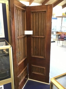 Queenscliffe Maritime Museum
Functional object - Doors
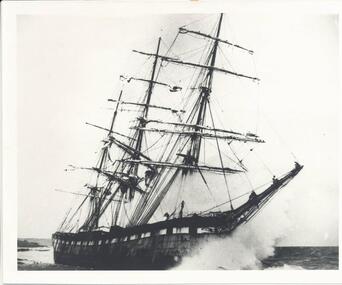
There are only seven shipwrecks in Victoria that have had more than 100 objects recovered from them reported as a result of the Commonwealth Amnesty held in 1993-94. These are the Loch Ard (1878), Schomberg (1855) and Fiji (1891) - all situated along the western district 'Shipwreck Coast' - and the George Roper (1883), Light of the Age (1868), Joseph H. Scammell (1891) and Victoria Tower - all situated along the short section of the 'Surf Coast' between Point Lonsdale and Torquay.The Victoria Tower is archaeologically significant as the wreck of an international inward-bound passenger and cargo vessel. It is educationally and recreationally significant as a coherently intact example of a British built iron clipper ie: representative of a class or type. Along with the wrecks of the Light of the Age (1868 - American-built wooden clipper ship) and Sussex (1871 - Blackwall frigate) nearby these vessels represent the three major design classes, and span the evolution of commercial and immigrant sailing ships used by the British in the colonial Australian trade in the last half of the nineteenth century.2 Doors from the 'Victoria Tower' made from teak and mahoganydoors, salvage, shipwreck, torquay, victoria tower -
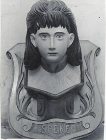 Phillip Island and District Historical Society Inc.
Photograph
One of a collection of over 400 photographs in an album commenced in 1960 and presented to the Phillip Island & Westernport Historical Society by the Shire of Phillip IslandPhotograph of the restored figurehead of the shipwrecked "Speke". Now resides in the Phillip Island & District Society Museum in Cowes - 2017.local history, photography, figurehead of the "speke", black & white photograph, sailing ships, figureheads, john jenner, bryant west -
Port Melbourne Historical & Preservation Society
Plant specimen - Relics, From SS Nairana, shipwrecked on Sandridge Beach
Bag containing pieces of coal and one piece of timber salvaged from SS Nairana shipwrecked on Sandridge Beachtransport - shipping, don hossack, ss nairana -
Lakes Entrance Historical Society
Book, M Holding, Fishing Industry Wrecks and Drownings
A folder of some information on fishing industry boats shipwrecks and deaths associated with the work place Lakes Entrance Victoriaboats and boating, ships and shipping, shipwrecks -
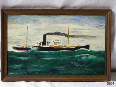 Flagstaff Hill Maritime Museum and Village
Painting - Vessel, Steamship, Mike McCrea (artist), ca 1985
... shipwrecked-coast ...This is one of a pair of paintings by artist Mike McCrea, created when he was in Warrnambool in 1985. The painting was framed and sold by Patana Galleries, Paton Place, Manly Vale, NSW. It was later purchased by athe company of Master Mariners of Australia and who donated the pair to Flagstaff Hill. The pair of paintings are significant for their association with steamships and the Master Mariners of Australia group. The paintings represent a time in local history when many steamships were sailing the coast and transporting passengers and goods.Painting; timber framed oil painting with the image of a cargo steamship off the coast of Warrnambool. Artist is Mike McCrea. Framed by Patana Galleries, Manly Vale, NSW. Hand written, "Red. No. 390 A" Sticker "61"flagstaff hill, warrnambool, shipwrecked-coast, flagstaff-hill, flagstaff-hill-maritime-museum, maritime-museum, shipwreck-coast, flagstaff-hill-maritime-village, painting, mic mccrea, patana galleries, master mariners of australia, steamship -
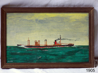 Flagstaff Hill Maritime Museum and Village
Painting - Vessel, Steamship, Mike McCrea (artist), ca 1985
... shipwrecked-coast ...This is one of a pair of paintings by artist Mike McCrea, created when he was in Warrnambool in 1985. The painting was framed and sold by Patana Galleries, Paton Place, Manly Vale, NSW. It was later purchased by athe company of Master Mariners of Australia and who donated the pair to Flagstaff Hill. The pair of paintings are significant for their association with steamships and the Master Mariners of Australia group. The paintings represent a time in local history when many steamships were sailing the coast and transporting passengers and goods.Painting, framed oil on board; cargo steamship off the coast of Warrnambool by artist Mike McCrea. Framed by Patana Galleries, Manly Vale, N.S.W. Signed by artist.Signed; "MIKE" "J15/62 McCrea" "Red. No. 390 A" Sticker with "62" "PATANA GALLERIES / PATON PLACE, MANLY VALE / PHONE 949-1535"flagstaff hill, warrnambool, shipwrecked-coast, flagstaff-hill, flagstaff-hill-maritime-museum, maritime-museum, shipwreck-coast, flagstaff-hill-maritime-village, painting, mike mccrea, steamship, master mariners of australia, patana galleries -
Glenelg Shire Council Cultural Collection
Letter - Letter - Invitation 'Shipwrecks' Part of Admella 150 Festival, Aug-09
Invitation, black print on bluecard, from Portland Bay Press, exhibition titled 'Shipwrecks' Part of Admella 150 Festival. -
Lakes Entrance Historical Society
Book, Holding M, Shipwrecks, 2010
Information on shipwrecks drownings and shipping adjacent to the entrance to the lakes also various other unrelated information gipplsand Lakes Victoriashipwrecks, fishing industry -
Glenelg Shire Council Cultural Collection
Poster - Poster - Admella 150 Festival, c. 2009
Laminaterd A3 poster promoting Admella 150 festival events in the limestone coast and Discovery coast regions. Posters shades of blue with black and white printing. Admella 150 logo top left corner. Gold sponsors logo's top right. -
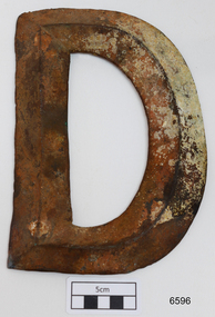 Flagstaff Hill Maritime Museum and Village
Plaque - Nameplate, Circa 1886
The brass letter “D” is from the starboard bow of the FALLS OF HALLADALE, a 2085 ton iron-hulled and four-masted sailing ship that was wrecked near Peterborough on 14 November 1908. Two companion pieces, the letters “S” and “A”, are also in the Flagstaff Hill Maritime Village collection of shipwreck artefacts (as registered numbers 748 and 6595). The ship’s name originally appeared in these impressively large brass letters across the stern and both port and starboard bows of the vessel. The FALLS OF HALLADALE was built in 1886 by Russell & Co at their Greenock shipyards on the River Clyde. She was the seventh of nine similar cargo carriers produced for the owners of the Falls Line, Wright, Breakenridge & Co of Glasgow. All nine ships were named after waterfalls in Scotland. First was the FALLS OF CLYDE in 1878, then the FALLS OF BRUAR in 1879 (lost in 1887), the FALLS OF DEE in 1882 (sunk in 1917), the FALLS OF AFTON in 1882, the FALLS OF FOYERS in 1883 (disappeared in 1898), the FALLS OF EARN in 1884 (wrecked in 1892), the FALLS OF HALLADALE in 1886 (wrecked in 1908), the FALLS OF GARRY in 1886 (wrecked in 1911), and the last of the fleet, the FALLS OF ETTRICK (lost in 1906). The FALLS OF CLYDE is still afloat as an exhibit at the Hawaii Maritime Center in Honolulu. Russell & Co delivered the owners full-bottomed, economical ships of 1800 to 2000 tons, practically designed to minimise loss of speed while increasing seaworthiness and carrying capacity. The sturdily constructed FALLS OF HALLADALE had iron masts and wire rigging, allowing her to maintain full sail even in gale conditions, and square “warehouse-type” bilges to accommodate maximum bulk cargo on her long-haul voyages. This class of ship remained commercially competitive into the twentieth century despite the advantages of coal-fired steamships. When the 22 years old FALLS OF HALLADALE finally foundered on Victoria’s Shipwreck Coast in 1908, the Melbourne Court of Marine Inquiry found it was entirely due to Captain D.W. Thomson’s navigational error, rather than any technical failure of the Clyde-built ship. The shipwreck of the FALLS OF HALLADALE is of state significance — Victorian Heritage Register No. S255. The Falls of Halladale shipwreck is listed on the Victorian Heritage Register (No. S255). She was one of the last ships to sail the Trade Routes. She is one of the first vessels to have fore and aft lifting bridges. She is an example of the remains of an International Cargo Ship and also represents aspects of Victoria’s shipping industry. The wreck is protected as a Historic Shipwreck under the Commonwealth Historic Shipwrecks Act (1976).Large brass letter “D”, from the shipwreck FALLS OF HALLADALE, dented but in generally good unrestored condition. Front face of dull grey-green metal showing reddish oxide stain and some cream-coloured concretisation. Rear face has not been brushed clean and displays more encrustation.The four bolt collars for fixing letter to ship are filled with sediment.warrnambool, shipwreck coast, flagstaff hill, shipwrecked coast, flagstaff hill maritime village, flagstaff hill maritime museum, shipwreck artefact, maritime museum, great ocean road, brass lettering, falls of halladale, 1908 shipwreck, russell & co., ship nameplate, nameplate, letter, letter d -
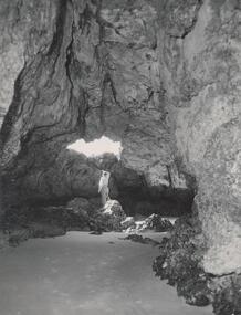 Phillip Island and District Historical Society Inc.
Photograph, Bryant West
One of a collection of over 400 photographs in an album commenced in 1960 and presented to the Phillip Island & Westernport Historical Society by the Shire of Phillip IslandPhotograph inside Forrest Caves South Coast Phillip Island. Man inside looking out. local history, photography, photographs, coastline, caves, phillip island, forrest caves phillip island, john jenner, bryant west -
Glenelg Shire Council Cultural Collection
Souvenir - Keyring - Portland Coast Region Water Authority, n.d
Key ring - Portland Coast Region Water Authority, gold coloured metal, enamelled designsouvenir, advertising -
Glenelg Shire Council Cultural Collection
Accessory - Badge - Bridgewater Sports, n.d
Metal badge, Bridgewater Sports New Year's Day with image of Cape Bridgewater and coast; roundcelebration, new years day, badge, cape bridgewater -
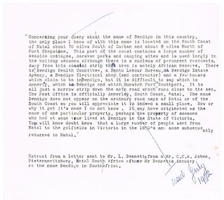 Bendigo Historical Society Inc.
Document - BENDIGO - NATAL, 07/1972
Typed notes about a query about the name of Bendigo on the South Coast of Natal, South Africa.document, bendigo - natal, mr l bennetts, mr c c w johnn -
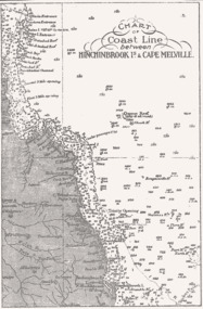 Queenscliffe Maritime Museum
Map - B & W coastal map of Hinchinbrook Island to Cape Melville in Queensland, Coastal map Queensland Hinchinbrook Is to Cape Melville, Before donation in 1987
Australian coastal mapsAustralian coastal mapsMap from unknown book of Queensland coast Hinchinbrook Island to Cape Melville, pre 1987Reverse " NIL "old maps of australian coast -
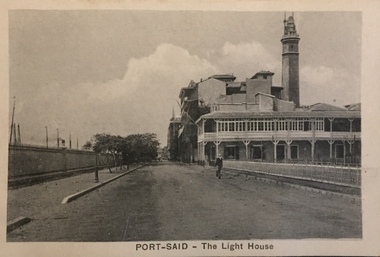 Kew Historical Society Inc
Postcard, The Cairo Postcard Trust, Port-Said - The Lighthouse, c.1918
One of a number of 'real photo' and commercial postcards created by or owned by members of the Christian and Washfold families of Kew. The postcards are part of a larger collection of photographs, postcards and publications donated to the collection in May 2021.Sepia postcard of Lighthouse at Port Said, located on the north east coast of Egypt on the Mediterranean Sea.The Cairo Postcard Trust Cairo 957 / Serle 632washfold family, postcards -- port said, christian family, christian-washfold collection -
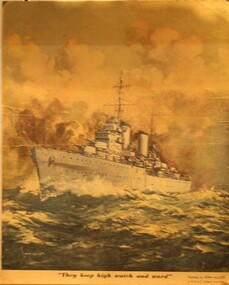 Ringwood RSL Sub-Branch
Printed Display item, Circa WW2
Coloured print of the HMAS Sydney which was lost with all hands of the Western Australian Coast in WW2"They keep high watch and ward" The HMAS Sydney in action by John Allcot.