Showing 521 items
matching studley
-
 Kew Historical Society Inc
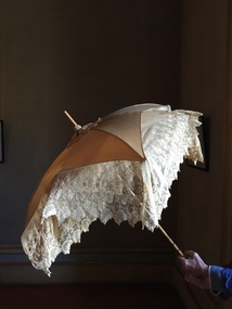
Accessory - Cream Silk & Lace Parasol, c. 1900
Joseph Butterworth COOMBS (1842-1901), was an accountant who founded a successful mercantile trading company. At the time of his marriage to Caroline Mary MICHEL in 1869, Coombs had already purchased ten acres of Studley Park. The acreage included land on the west of Fenwick Street that extended along lower Stawell Street to the corner of Yarra Street, all of it connected directly to the Yarra environs. A right of way to Studley Park Road was on the title, though Coombs went on to purchase more land, some of which faced Studley Park Road. In addition to owning the Studley Park acreage, Coombs later acquired 1,201 acres of land abutting the Acheron River. While retaining the Kew property he became a Taggerty Councillor and was Shire President for a time. J.B. Coombs died at Acheron Station in 1901 (aged 59 years). A few months after, tenders were called to repair the Kew dwelling, the Fenwick Street property now appearing in records with the name ‘Hope Mansell’. Caroline Coombs remained at Hope Mansell until she died in 1924, survived by three sons and five daughters. Not long after her death, advertisements appeared for the sale of the Studley Park land. The sale seems to have been a mechanism for distribution of the Estate, as the following year the original ten acre holding was transferred to members of the family. The eldest daughter Mabel married William Younger who, with his brother Alexander, developed Younger and Mackie Courts, both south of Studley Park Road. [Research: Kerry Fairbank]In 1961, the granddaughter of Joseph and Caroline Coombs, Mabel Isola (Younger) Grattan, donated ten 19th century dresses and parasols to the Kew Historical Society. The costumes, now known as the 'Coombs Collection', are the earliest recorded items of clothing to enter the Society's collection. Each of the items in the Coombs Collection, of which this item forms a part, is historically, aesthetically and socially significant. As a collection, the costumes includes outstanding examples of morning wear, day dresses, wedding dresses, and clothing accessories, providing evidence of outstanding dressmaker skills in Victoria during the mid to late Victorian period. One of a pair of cream silk parasols, each bordered by overlapping bands of beige lace. The underlying structure and mechanism includes a bent cane handle and black metal expanding spokes. The lace borders are layered to create an overlapping fringe. The high-domed umbrellas may have been created for a bridal party. This umbrella cannot be opened due to the silk being shattered."Coombs Collection"coombs collection, clothing accessories, parasols -
 Kew Historical Society Inc
Clothing - Quilted Wool & Silk Afternoon Dress, c.1878
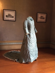
Joseph Butterworth COOMBS (1842-1901), was an accountant who founded a successful mercantile trading company. At the time of his marriage to Caroline Mary MICHEL in 1969, Coombs had already purchased 10 acres of Studley Park. The acreage included land on the west of Fenwick Street that extended along lower Stawell Street to the corner of Yarra Street, all of it connected directly to the Yarra environs. A right of way to Studley Park Road was on the title, though Coombs went on to purchase more land, some of which faced Studley Park Road. In addition to owning the Studley Park acreage, Coombs later acquired 1,201 acres of land abutting the Acheron River. While retaining the Kew property he became a Taggerty Councillor and was Shire President for a time. J.B. Coombs died at Acheron Station in 1901 (aged 59 years). A few months after, tenders were called to repair the Kew dwelling, the Fenwick Street property now appearing in records with the name ‘Hope Mansell’. Caroline Coombs remained at Hope Mansell until she died in 1924, survived by three sons and five daughters. Not long after her death, advertisements appeared for the sale of the Studley Park land. The sale seems to have been a mechanism for distribution of the Estate, as the following year the original 10 acre holding was transferred to members of the family. The eldest daughter Mabel married William Younger who, with his brother Alexander, developed Younger and Mackie Courts, both south of Studley Park Road. [Research: Kerry Fairbank]In 1961, the granddaughter of Joseph and Caroline Coombs, Mabel Isola (Younger) Grattan, donated ten 19th century dresses and parasols to the Kew Historical Society. The costumes, now known as the 'Coombs Collection', are the earliest recorded items of clothing to enter the Society's collection. Each of the items in the Coombs Collection, of which this item forms a part, is historically, aesthetically and socially significant. As a collection, the costumes includes outstanding examples of morning wear, day dresses, wedding dresses, and clothing accessories, providing evidence of outstanding dressmaker skills in Victoria during the mid to late Victorian period. Periwinkle blue afternoon dress made of finely woven wool with silk quilting to the yoke and cuffs. The one-piece outfit is fastened at front with large mother of pearl buttons. The dress includes a very long train. At one stage, the buttoning at the waist has been modified, presumably due to changes in the owner's waistline. women's clothing, australian fashion, costumes, dresses -
 Kew Historical Society Inc
Plan, Melbourne & Metropolitan Board of Works : Borough of Kew : Detail Plan No.1291, 1905
The Melbourne and Metropolitan Board of Works (MMBW) plans were produced from the 1890s to the 1950s. They were crucial to the design and development of Melbourne's sewerage and drainage system. The plans, at a scale of 40 feet to 1 inch (1:480), provide a detailed historical record of Melbourne streetscapes and environmental features. Each plan covers one or two street blocks (roughly six streets), showing details of buildings, including garden layouts and ownership boundaries, and features such as laneways, drains, bridges, parks, municipal boundaries and other prominent landmarks as they existed at the time each plan was produced. (Source: State Library of Victoria). This plan forms part of a large group of MMBW plans and maps that was donated to the Society by the Mr Poulter, City Engineer of the City of Kew in 1989. Within this collection, thirty-five hand-coloured plans, backed with linen, are of statewide significance as they include annotations that provide details of construction materials used in buildings in the first decade of the 20th century as well as additional information about land ownership and usage. The copies in the Public Record Office Victoria and the State Library of Victoria are monochrome versions which do not denote building materials so that the maps in this collection are invaluable and unique tools for researchers and heritage consultants. A number of the plans are not held in the collection of the State Library of Victoria so they have the additional attribute of rarity.Original survey plan, issued by the MMBW to a contractor with responsibility for constructing sewers in the area identified on the plan within the Borough of Kew. The plan was at some stage hand-coloured, possibly by the contractor, but more likely by officers working in the Engineering Department of the Borough and later Town, then City of Kew. The hand-coloured sections of buildings on the plan were used to denote masonry or brick constructions (pink), weatherboard constructions (yellow), and public buildings (grey). A detail plan of part of Studley Park bordered by the major streets of Hodgson Street, Stevenson Street and Studley Park Road. Included on the plan are a number of significant Studley Park mansions in existence at the beginning of the 20th century. The unnamed street shown in the middle of the plan is McEvoy Street. The most important house still extant is Campion House, formerly named Dalsraith [Dalswraith] and Glendalough, owned since the 1940s by the Society of Jesus. Campion House can be seen on the corner of Hodgson and Studley Park Road. Its stables at the rear of the block have now been incorporated into a contemporary residence. An interesting feature of the plan is the 1910 annotation by Ed Seitz, professional designing engineer. Is Seitz the contractor who modified the MMBW original?melbourne and metropolitan board of works, detail plans, mmbw 1291, cartography -
 Kew Historical Society Inc
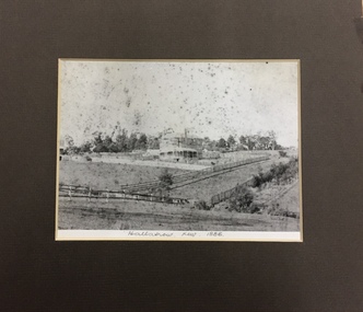
Photograph, 'Hallatrow', Holroyd Street, Kew, 1886
An important early photograph of a significant Kew mansion - Hallatrow - dating from 1886, soon after it was constructed.What appears to be a reprint of an earlier photograph of Hallatrow, now mounted, originally listed as A'Beckett Street West or Conran Street, but now 6 Holroyd Street in Studley Park. The photograph was originally taken when the house was occupied by the family of Thomas Brodribb. Pencil: “Hallatrow, Kew, 1886” hallatrow - 6 holroyd street - kew )vic), historic buidlings - studley park - kew (vic) -
 Kew Historical Society Inc
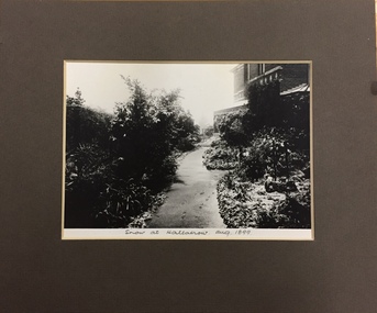
Photograph, Snow at Hallatrow, Aug 1899, 1899
An important early photograph of a significant Kew mansion - Hallatrow - dating from 1899.What appears to be a reprint of an earlier photograph of Hallatrow, now mounted, originally listed as A'Beckett Street West or Conran Street, but now 6 Holroyd Street in Studley Park. The photograph was originally taken when the house was occupied by the family of Thomas Brodribb. Pencil: “Snow at Hallatrow, Aug 1899” hallatrow - 6 holroyd street - kew )vic), historic buidlings - studley park - kew (vic) -
 Kew Historical Society Inc
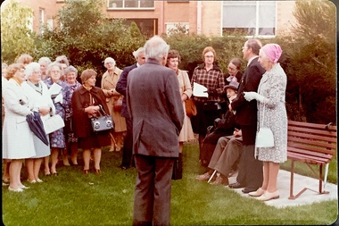
Photograph - Opening of the Dorothy Rogers Reserve, 1976
Dorothy Rogers wrote two major books on Kew's history: Lovely Old Homes of Kew (1961) and A History of Kew (1973). In addition to her published works, she was a regular contributor on issues of local history to suburban newspapers. Her archives are held in the collections of the State Library of Victoria and Kew Historical Society. Three years after her death in 1973, the Reserve was opened in her honour.Faded colour positive photograph of the opening of the Dorothy Rogers Reserve in 1976. The naming of the reserve honoured the contribution of the historian Dorothy Rogers, foundation member of the Society. The reserve is located on the north side of Studley Park Road just west of Kew Junction. Inscribed verso: "Members and relatives of the late Dorothy Rogers. Memorial reserve named and unveiled in her honour by (Cr Whiting Mayor) and City Manager Mr Fell 1978. In respect for her great research and service to the history of early Kew, and other places."dorothy rogers reserve, public parks -- kew (vic.) -
 Kew Historical Society Inc
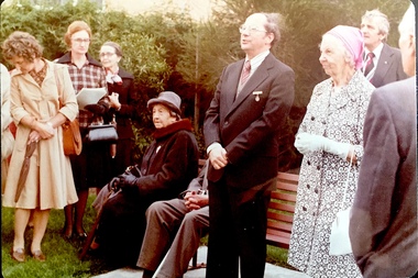
Photograph - Opening of the Dorothy Rogers Reserve, 1976
Dorothy Rogers wrote two major books on Kew's history: Lovely Old Homes of Kew (1961) and A History of Kew (1973). In addition to her published works, she was a regular contributor on issues of local history to suburban newspapers. Her archives are held in the collections of the State Library of Victoria and Kew Historical Society. Three years after her death in 1973, the Reserve was opened in her honour.Faded colour positive photograph of the opening of the Dorothy Rogers Reserve in 1976. The naming of the reserve honoured the contribution of the historian Dorothy Rogers, foundation member of the Society. The reserve is located on the north side of Studley Park Road just west of Kew Junction. Inscribed verso: "Left to right: Mrs Rogers Jnr, Joy Stewart, Miss Jenkins sitting / Mrs Richardson and Mr Richardson, Brother of D. Rogers), Mayor Cr Whiting, City Manager Mr Fell, Background / KHS President Miss Hall, Mr B O'Neill KHS member, / taken during the memorial unveiling of the Dorothy Rogers Reserve"dorothy rogers reserve, public parks -- kew (vic.) -
 Kew Historical Society Inc
Photograph - View of the Yarra River from 8 Kellett Grove, North Kew, 1948
North Kew, now divided between Kew and Kew East, bordered the Yarra River. As such, it was a region subject to flooding in the Yarra Valley. Development beyond this point (ie Kellett Grove) was limited by the City of Kew's planning regulations. Prior to urban development, the area since European settlement and the first land sales in the district in the 1840s, had been used for dairy farming. The view from the rear of 8 Kellett Grove predates the construction of the Eastern Freeway so provides a rare view of the area before it was built.Small sepia snapshot taken from the back yard of a house at 8 Kellett Grove, in what was then known as North Kew. A tower of the Kew Asylum on the top left of the horizon assist the viewer to recognise that the land to the left of the river is in Kew and Studley Park.Verso: NORTH KEW 1948 / Stamped 51019yarra river -- north kew, kellett grove -- north kew -
 Kew Historical Society Inc
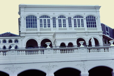
Slide - 'Burke Hall', Nolan Avenue, 1976
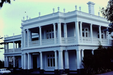
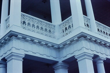
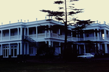
Colour transparency (slide) created in June 1976 during a tour by the Junior National Trust, which was led by members of Kew Historical Society. The collection of 21 slides reveals that the tour covered all parts of Kew, but focused understandably on heritage buildings and sites.Image of an historic place in Kew that can be dated to an exact time and place. The images, albeit amateurish in composition, frequently reveal aspects of important buildings and sites that have changed over time.35mm colour transparency of Burke Hall (formerly Studley House, Waverley) showing the front facade facing south away from Nolan Avenue and Studley Park Road. Now Xavier Junior School, the Victorian Heritage Register describes the building as: "...a largely intact mansion commenced in the mid-Victorian period that was sympathetically added to during the nineteenth century and as such, is one of the key Victorian buildings to have been built in Kew. the historical associations with figures such as Charles C. Staples and Carl Pinschof enhance the significance, while the additions made to the house in recent years detract from it."historic houses -- kew (vic.), nolan avenue -- kew (vic), xavier college -- kew (vic.), burke hall, waverley, studley hall -
 Kew Historical Society Inc
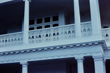
Slide - 'Studley House', Nolan Avenue, 1976
Colour transparency (slide) created in June 1976 during a tour by the Junior National Trust, which was led by members of Kew Historical Society. The collection of 21 slides reveals that the tour covered all parts of Kew, but focused understandably on heritage buildings and sites.Image of an historic place in Kew that can be dated to an exact time and place. The images, albeit amateurish in composition, frequently reveal aspects of important buildings and sites that have changed over time.35mm colour transparency of Studley House in Nolan Avenue, Kew, now part of Xavier Primary School. The Victorian Historic Buildings Register describes the building as: ""Studley House", 15 Nolan Avenue Kew is an early house, extensively added to, which is of architectural importance in its present form and has important historical associations with John Hodgson, an early settler in the district and with subsequent owners. The first part of the house is an early and particularly fine example of the Italianate style in Victoria. The later additions dwarf the original house but are of interest in their own right. Plaster and woodwork internally and some stained glass are notable."historic houses -- kew (vic.), nolan avenue -- kew (vic), xavier college -- kew (vic.), studley house -- nolan avenue -- kew (vic.) -
 Kew Historical Society Inc
Slide - 'Studley House', Nolan Avenue, 1976
Colour transparency (slide) created in June 1976 during a tour by the Junior National Trust, which was led by members of Kew Historical Society. The collection of 21 slides reveals that the tour covered all parts of Kew, but focused understandably on heritage buildings and sites.Image of an historic place in Kew that can be dated to an exact time and place. The images, albeit amateurish in composition, frequently reveal aspects of important buildings and sites that have changed over time.35mm colour transparency of Studley House in Nolan Avenue, Kew as it appeared in 1976. The oldest parts of the house were constructed for John Hodgson in the1850s. Later additions were made when John Wren was the owner. The house is now part of Xavier Primary School.. historic houses -- kew (vic.), xavier college -- kew (vic.), nolan avenue -- kew (vic.), john wren, john hodgson -
 Kew Historical Society Inc
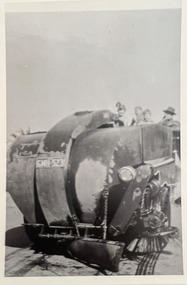
Photograph - City of Kew steamroller and workers, c. 1960
Tom Bentley (1912-1993) was born in Lancashire (UK). From circa 1951, he was the Overseer/Superintendent of Outdoor Works for Kew City Council. Until his retirement in the 1970s, he was based at the Kew Council Depot, located in the former MTB Horse Tram Depot on the corner of Disraeli and High Streets, Kew. Accompanying the set of twelve photographs is a 12-page illustrated biography of the Bentley and Plumridge families, separately kept in the 'Bentley' subject file.Duplicate black and white positive print photograph of road works in Studley Park Road, Kew, carried out under the supervision of Tom Bentley, Overseer/Superintendent of Outdoor Works for the City of Kew. The photograph shows a Council-owned steamroller used for road construction.city of kew, public works, tom bentley, road works, steamrollers -
 Kew Historical Society Inc
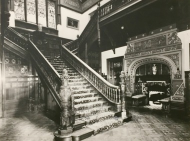
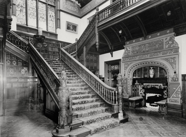
Photograph - Staircase in the Main Hall of 'Tara Hall', Kew, Marc Strizic, c.1960
Edward George Kilburn, of Ellerker & Kilburn, designed 'Byram' (later renamed 'Goathland', 'Lowa' and 'Tara Hall') for the industrialist George Ramsden in 1888. The mansion, one of the most significant in Kew, was demolished in 1960.This is an original small photograph of this historic Kew mansion with provenance by descent from the first owners of the house.An angled view of the main hallway and staircase of Tara Hall (previously named Byram, Goathland and Lowan). To the right of the staircase in this Studley Park Road mansion, was a large inglenook fireplace surrounded by stucco decoration. The latter was a characteristic of the architect, Edward G. Kilburn’s late style.Inscription reverse: "Interior Tara Hall, demolished 1960. Donated by Grandson [Peter Ramsden] of original owner George Ramsden. Home was also called Goathlands [sic] during its ownership by Sir Malcolm McEacharn. Other owners - Mrs F Treadway, Count O'Loughlin, Dr Edward Ryan, Mrs Evans, Royal Womens' Hosp. KH-324"byram, tara hall, lowan, goathland, edward g. kilburn (architect), george ramsden -
 Kew Historical Society Inc
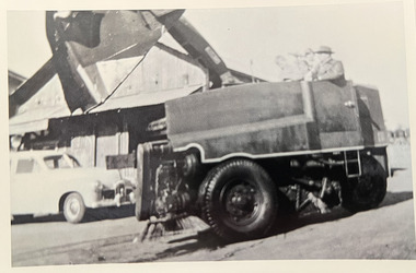
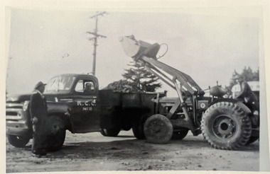
Photograph - City of Kew vehicles and workers, c. 1960
Tom Bentley (1912-1993) was born in Lancashire (UK). From circa 1951, he was the Overseer/Superintendent of Outdoor Works for Kew City Council. Until his retirement in the 1970s, he was based at the Kew Council Depot, located in the former MTB Horse Tram Depot on the corner of Disraeli and High Streets, Kew. Accompanying the set of twelve photographs is a 12-page illustrated biography of the Bentley and Plumridge families, separately kept in the 'Bentley' subject file.Duplicate black and white positive print photograph of road works in Studley Park Road, Kew, carried out under the supervision of Tom Bentley, Overseer/Superintendent of Outdoor Works for the City of Kew. The photograph shows a Council-owned front end loader and a Council trailer.city of kew, public works, tom bentley -
 Kew Historical Society Inc
Archive (series) - Subject File, LUSH, Joseph
Kew Historical SocietySince its foundation in 1958, members of the Kew Historical Society have been compiling and storing information about subjects relating to the history of Kew and its environs, of which this file is an example. Arranged by Secondary Values (value of records to users)Subject file containing information about Joseph Lush of Moubray, Lush and Co, an earlier European landowner in Kew, initially in Studley Park Road. The file contains a copy of his last will and testament, which include information about his property - Walmer House - in Walmer Street, Kew.joseph lush, walmer house -- walmer street -- kew (vic.)joseph lush, walmer house -- walmer street -- kew (vic.) -
 Kew Historical Society Inc
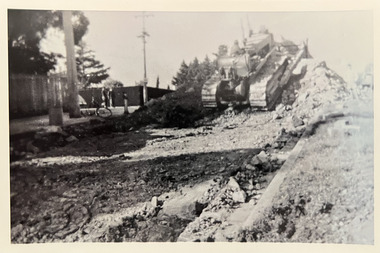
Photograph - Road-making, Studley Park Road, c. 1960
Tom Bentley (1912-1993) was born in Lancashire (UK). From circa 1951, he was the Overseer/Superintendent of Outdoor Works for Kew City Council. Until his retirement in the 1970s, he was based at the Kew Council Depot, located in the former MTB Horse Tram Depot on the corner of Disraeli and High Streets, Kew. Accompanying the set of twelve photographs is a 12-page illustrated biography of the Bentley and Plumridge families, separately kept in the 'Bentley' subject file.Duplicate black and white positive print photograph of road works in Studley Park Road, Kew, carried out under the supervision of Tom Bentley, Overseer/Superintendent of Outdoor Works for the City of Kew. The location at which the photograph was taken is believed, by the donor, to be in the vicinity of Tara Hall (dem. 1960).city of kew, public works, road-making, studley park road, tom bentley -
 Kew Historical Society Inc
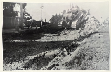
Photograph - Road construction in Studley Park Road, c. 1960
Tom Bentley (1912-1993) was born in Lancashire (UK). From circa 1951, he was the Overseer/Superintendent of Outdoor Works for Kew City Council. Until his retirement in the 1970s, he was based at the Kew Council Depot, located in the former MTB Horse Tram Depot on the corner of Disraeli and High Streets, Kew. Accompanying the set of twelve photographs is a 12-page illustrated biography of the Bentley and Plumridge families, separately kept in the 'Bentley' subject file.Duplicate black and white positive print photograph of road works in Studley Park Road, Kew, carried out under the supervision of Tom Bentley, Overseer/Superintendent of Outdoor Works for the City of Kew. The blurred photograph shows Council-owned vehicles used for road construction and council workers.city of kew, public works, tom bentley, road works -
 Kew Historical Society Inc
Album - Scrapbook, Eva Grant, Historic Buildings, Kew, 1958-78, 1970s
One of three scrapbooks of photographs and newspaper cuttings taken and or collected by Eva Grant, a past member of the Kew Historical Society, which were donated by her niece, Julie Thomson. The albums include many photographs of Kew from the 1950s to the 1970s. Buildings included in the scrapbook include: Billy Hughes' house - 167 Cotham Road Congregational Church - Walpole Street (c.1978) Country Roads Board - Denmark Street (1960) Dorothy Rogers Reserve - Studley Park Road Ellsmere (also Ellesmere/Ellsmore) - Princess Street Field Place - 3 Henty Court Fernhurst - 13 Fernhurst Grove Kew Civic Centre (1959) Kew Junction (1958) Kew Railway Station (1902, 1959) Kew Recreation Hall - Wellington Street (1960) Neama (Hall) - Studley Park Road Southesk (formerly Ordsall) - Cotham Road (c.1960) St Anthony's Home for Babies (formerly Madford) - 43 Wellington Street (c.1976) Studley House - Nolan AvenueThe scrapbook contains historically significant, rare and sometimes unique images of significant heritage buildings in Kew, including their erection and demolition. 11-page scrapbook of photographs and newspaper clippings with annotations by Eva Grant, a past member of the Kew Historical Society. The pages of the album can be viewed in the image carousel above. Based on the text and known dates of demolition of a number of the buildings, the scrapbook was assembled over a twenty year period between c.1958-c.1978.Includes letter from donoreva grant, billy hughes' house - 167 cotham road, congregational church - walpole street - kew, country roads board - denmark street - kew, dorothy rogers reserve - studley park road - kew, field place - 3 henty court - kew (vic), ellsmere (also ellesmere/ellsmore) - princess street - kew, fernhurst - 13 fernhurst grove - kew (vic), kew civic centre - civic drive - kew (vic), kew junction - kew (vic), kew railway station - denmark street - kew (vic), recreation hall - wellington street - kew, neama - hall - studley park road - kew (vic), southesk - ordsall - cotham road- kew (vic), st anthony's home for babies - madford - 43 wellington street (vic), studley house - nolan avenue - kew (vic) -
 Kew Historical Society Inc
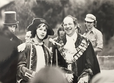
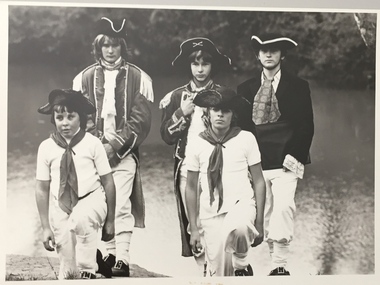
Photograph, Standard Newspapers, Charles Grimes Re-enactment, Yarra River, 1978
The party of the British surveyor Charles Grimes were the first Europeans to view the River Yarra, as it was later to be named. Members of the party reached the area now known as Studley Park in 1803. This local re-enactment commemorated 175 years since that event. Charles Grimes Re-Enactment, Yarra River, Kew, 1978. The photograph is of a student of Trinity Grammar School and the Mayor of Kew, Cr. Whiting. Inscription on reverse: "KH-161. Society's contribution to the 1978 Festival of Kew. Re-enactment of first white man's journey and discovery of the Yarra River and the area now know (sic) as Kew. 1978. This was in the year 1903 when Grimes and party came upon the Yarra to seek a possible site for a new convict settlement. Cr. Whiting, Mayor of Kew, receiving the report from Grimes, 'Andrew Allen'. Cr. Hutchinson in top hat 'town cryer'. Bush band in backround." Ripped stamp on reverse: "Standard N[ewspapers]."charles grimes re-enactment, trinity grammar school, cr whiting -- mayors -- kew (vic.), yarra river, andrew allen, kew historical society -
 Kew Historical Society Inc
Photograph, Standard Newspapers, Charles Grimes Re-enactment, Yarra River, 1978
The party of the British surveyor Charles Grimes were the first Europeans to view the River Yarra, as it was later to be named. Members of the party reached the area now known as Studley Park in 1803. This local re-enactment commemorated 175 years since that event.Charles Grimes, Re-enactment, Yarra River, Kew, 1978. Inscription on reverse: "Trinity Grammar School students taking part in Grimes' journey up the Yarra, 1803. Re-enactment Historical Society Kew contribution to the 1978 Festival of Kew."charles grimes re-enactment, trinity grammar school, cr whiting -- mayors -- kew (vic.), yarra river, andrew allen, kew historical society -
 Kew Historical Society Inc
Photograph, Standard Newspapers, Charles Grimes Re-enactment, Yarra River, 1978
The party of the British surveyor Charles Grimes were the first Europeans to view the River Yarra, as it was later to be named. Members of the party reached the area now known as Studley Park in 1803. This local re-enactment commemorated 175 years since that event.Charles Grimes, Re-enactment, Yarra River, Kew, 1978. Inscription on reverse: "KH-191. Grimes' party in boat on Yarra 1978. Re-enactment organised by Kew Historical Society. Actors Trinity Grammar boys. Mrs Argyle's History class." Sticker on back: "771. Standard News. WHS. Festival. 4 cols. May 3. [Page] 5."charles grimes re-enactment, yarra river (kew) 1978, cr whiting (mayor of kew), andrew allen, trinity grammar school, kew historical society -
 Kew Historical Society Inc
Photograph - Staircase of 'Tara Hall', Studley Park Road, Marc Strizic (attrib), c.1960
'Lost Glories: a memorial to forgotten Australian buildings' was published by David Latta in 1986. It tells the story of a number of significant Australian buildings that had previously been demolished. A chapter in the book was devoted to Goathland, later known as Tara Hall. To supplement the text, he sourced photographs from a range of suppliers, chiefly the Royal Women's Hospital which had once owned Tara Hall, but had sold it in 1960. This is one of the photographs donated to KHS by the author. The Staircase at Tara Hall, circa 1957. An angled view of the main hallway and staircase of Tara Hall (previously named Byram, Goathland and Lowan). To the right of the staircase in this Studley Park Road mansion, a large inglenook fireplace was located, which was surrounded by stucco decoration. The latter was a characteristic of E. G. Kilburn’s late style.Typed inscription on reverse: "The Staircase at Tara Hall. Above the ornate fireplace is the legend 'Come When You Mind, A Welcome Find'. (Royal Women's Hospital, Melbourne)." byram, goathland, tara hall, lowan, studley park (kew), george ramsden, sir malcolm mceacharn, edward george kilburn (architect), studley park road (kew) -
 Kew Historical Society Inc
Work on paper - Sepia Wash & Ink, G B Richardson, Creek and Old Watering Stage, on the Yarra, East Collingwood, 1854
Blind Creek was located between the Abbotsford Convent and what is now the Collins Bridge in Studley Park. In an 1858 map of East Collingwood by Clement Hodgkinson, in the State Library of Victoria, one can see how the creek was originally a significant landmark in Collingwood; remaining vacant land until a barrel drain enclosed it. The area was later filled in, surveyed and developed. The position where Blind Creek entered the Yarra was in the immediate vicinity of Hodgson’s Punt, which had linked Kew to the other side of the Yarra from 1839. The Punt was purchased by the Colonial Government in 1852 and was in use until the opening of the Studley Park Road (Johnston Street) Bridge in 1858 made its continued use redundantThe point of view selected by the artist for the watercolour is from the banks of Blind Creek in East Collingwood, looking across the Yarra to the Kew side of the river.Inscribed verso 'Creek and Old Watering stage, on the Yarra East Collingwood 1854 / Trees, stage, &c have long since disappeared / [Artist Signature] / FT 110 / Creek itself now being filled in 1903.gb richardson, blind creek - abbotsford, yarra river - abbotsford (vic) - kew (vic), colonial artists, australian art - 19th century, george bouchier richardson -
 Kew Historical Society Inc
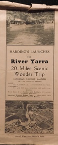
Flyer, Melbourne Ferries Pty Ltd, River Yarra: 20 Miles Scenic Wonder Trip
Bifold brochure including route map of the full 44 mile 'Wonder Trip' on pages 2 & 3. Photos used include an 'Aerial view over Dight's Falls', two ferries, and a 'Scene near Dight's Falls'.Flyer for Harding’s Launches on the River Yarra: 20 miles scenic wonder trip. Aerial view over Dight’s Falls on front. non-fictionBifold brochure including route map of the full 44 mile 'Wonder Trip' on pages 2 & 3. Photos used include an 'Aerial view over Dight's Falls', two ferries, and a 'Scene near Dight's Falls'.river yarra, melbourne ferries pty ltd, yarra river -- tourism, harding's cruises, christian-washfold collection -
Kew Historical Society Inc
Archive (Sub-series) - Subject File, Findon (Kew), 1958
Various partiesReference, Research, InformationSecondary Values (KHS Imposed Order)Subject file on Findon, an early mansion in Studley Park and its owners including the Hon Henry “Money” Miller. The two main items in the file are an extract from Victoria and Its Metropolis on Miller and an article on the organ that was once in the house and according to an article on the Organ Trust website, currently in the Wesley Uniting (formerly Methodist Church) in Box Hill. kew (vic) - history, findon, henry "money" miller, organs - victoriakew (vic) - history, findon, henry "money" miller, organs - victoria -
 Kew Historical Society Inc
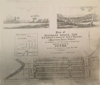
Print - Subdivision Plan, Rosebank Estate, Kew, Nineteenth Century
This work forms part of the collection assembled by the historian Dorothy Rogers, that was donated to the Kew Historical Society by her son John Rogers in 2015. The manuscripts, photographs, maps, and documents were sourced by her from both family and local collections or produced as references for her print publications. Many were directly used by Rogers in writing ‘Lovely Old Homes of Kew’ (1961) and 'A History of Kew' (1973), or the numerous articles on local history that she produced for suburban newspapers. Most of the photographs in the collection include detailed annotations in her hand. The Rogers Collection provides a comprehensive insight into the working habits of a historian in the 1960s and 1970s. Together it forms the largest privately-donated collection within the archives of the Kew Historical Society.A photographic reproduction of a plan in the Vale Collection of the State Library of Victoria. The plan shows the Rosebank Estate in Kew which was offered for sale in 1881. The subdivision was located in Studley Park and included lots in Redmond Street; Fellows Street; Wills Street; Molesworth Street; Barry Street and Princess Street. The surveyor of the subdivision was the local architect George Wharton.rosebank estate (kew), subdivisions -- studley park -- kew (vic.), thomas wills, wills family -
 Kew Historical Society Inc
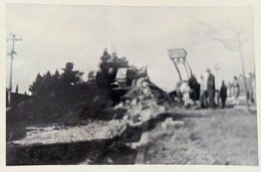
Photograph - Road works in Studley Park Road, c. 1960
Tom Bentley (1912-1993) was born in Lancashire (UK). From circa 1951, he was the Overseer/Superintendent of Outdoor Works for Kew City Council. Until his retirement in the 1970s, he was based at the Kew Council Depot, located in the former MTB Horse Tram Depot on the corner of Disraeli and High Streets, Kew. Accompanying the set of twelve photographs is a 12-page illustrated biography of the Bentley and Plumridge families, separately kept in the 'Bentley' subject file.Duplicate black and white positive print photograph of road works in Studley Park Road, Kew, carried out under the supervision of Tom Bentley, Overseer/Superintendent of Outdoor Works for the City of Kew. The location at which the photograph was taken is believed, by the donor, to be in the vicinity of Tara Hall (dem. 1960). The photograph shows two Council vehicles.city of kew, public works, studley park road, tom bentley, road works -
 Kew Historical Society Inc
Photograph - Road works in Studley Park Road, c. 1960
Tom Bentley (1912-1993) was born in Lancashire (UK). From circa 1951, he was the Overseer/Superintendent of Outdoor Works for Kew City Council. Until his retirement in the 1970s, he was based at the Kew Council Depot, located in the former MTB Horse Tram Depot on the corner of Disraeli and High Streets, Kew. Accompanying the set of twelve photographs is a 12-page illustrated biography of the Bentley and Plumridge families, separately kept in the 'Bentley' subject file.Duplicate black and white positive print photograph of road works in Studley Park Road, Kew, carried out under the supervision of Tom Bentley, Overseer/Superintendent of Outdoor Works for the City of Kew. The location at which the photograph was taken is believed, by the donor, to be in the vicinity of Tara Hall (dem. 1960). The photograph shows a Council vehicles shifting soil.city of kew, public works, studley park road, tom bentley, road works