Showing 313 items
matching sweet
-
 Eltham District Historical Society Inc
Negative - Photograph, Harry Gilham, Grave of Sarah and Phillip Shillinglaw, Eltham Cemetery, Victoria, Sep 2009
Philip Shillinglaw and his wife Sarah came to Eltham in 1882. Their property "Wattle Brae" originally encompassed present-day Eltham Central Park and part of Eltham Library, extending north to include Andrew Park and the site of the railway station. An early photo shows that much of it was planted for crops. They also had cows; in 1913 Philip wrote to the local paper complaining about an earlier report that one of them had been killed on the railway line. "I give an emphatic denial to the report. It is not true." Their house Shillinglaw Cottage (built by George Stebbings) still exists, though it was moved with funding from local residents in 1963-64 when faced with demolition to make room for new Council Offices. Philip was actively involved with the Methodist Church as preacher, Church Steward and Sunday School teacher. A Sunday School picnic and a sports carnival were held on his paddock. Eight of his children attended Eltham Primary School. In 1908 he ploughed part of the schoolyard (possibly for use as a garden) free of charge. When Philip died in 1914, his funeral was described as one of the largest ever seen in Eltham. He and Sarah are buried in Eltham Cemetery. In Loving Memory of Sarah Ann Shillinglaw Died 10th Dec. 1891 Also Phillip Loved husband of above Died 18th Aug. 1914 Sweet BestRoll of 35mm colour negative film, 6 stripsKodak GC 400-9eltham cemetery, gravestones, phillip shillinglaw, sarah ann shillinglaw -
 Coal Creek Community Park & Museum
Music Sheets
A collection of 41 music sheets. 5 - The Blackpool Walk / Angels of the Mons 6 - Love is Where you Find It / A Little Love, A Little Kiss 9 - Brown Eyes, Why are You Blue? / Poor Little Me 12 - My Dear / Why / You're as Pretty as a Picture / My Own (2 Copies) 13 - Cinderella Sweetheart / Hi-Ho Silver 14 - That Week In Paris / Two Sleep People 16 - Rock it for me / Say THat You Care For Me 17 - On The Bumpy Road to Love / There's Honey On The Moon Tonight 18 - The Same Sweet You / On Parade 21 - Cinderella / The Chestnut Tree 22 - Skating Down The Old Mill Stream / What Have You Got That Gets Me 26 - All Ashore / Sixty Seconds Got Together 32 - I Go For That / Junior 33 - The Great Waltz / Don't Wake Up My Heart 34 - Strike Up The Band / Kinda Lonesome 35 - Peace Of Mind / minute For Modern Miss 37 - The Night / Honolulu 38 - Hang Your Heart On A Rickory Limb / That Sly Old Gentleman 40 - Grandma Said / Something to Sing about 41 - Loving You / Killy-Ka-lee / I'll Still Be Loving You 91 - Waltzes From Vienna 96 - To You Sweetheart Aloha / Did I Remember 102 - At The Close Of A Long, Long Day / I Have Lost Me Heart In Budapest 111 - Man Of My Dreams / Life Is Empty Without Love 120 - Have You Ever Been Lonely / Sitting In The Dark 121 - And So I Married The Girl / Someone to Care For 122 - Thank Heaven For You / All Over Italy 123 - There's a Bridle Hanging On The Wall / You'll Never Go To Heaven 125 - There's a Lull in my Life / A Nic Cup Of Tea 138 - On Wings of a Song / Harmony Lane 149 - Swing it Here to Sway / The One Rose 150 - What Harlem is Tome 156 - Fifty Million Robins Can't Be Wrong / Nice Work If You Can Get It 162 - Sail Along, Silvery Moon / I Love To Whistle 164 - I Double Dare You / The Snake Charmer 168 - Sweet As A Song / Toodle Do 177 - I've Got A Pocketful of Dreams / When The Organ Played Promise Me 182 - This May Be The Night / I've Got A Date With A Dream 179 - At A Perfume Counter / On Linger Longer Island 183 - I Married An Angel / Spring is Here -
 Bendigo Historical Society Inc.
Newspaper - JENNY FOLEY COLLECTIONSNIPPETS OF BENDIGO
Bendigo weekly from Friday, November 1, 2002. Snippets of Bendigo history - Edith Lunn continues her stroll along a Pall Mall of earlier years - On the Williamson Street corner, across from the Shamrock Hotel, once stood the Bank of Australasia, later the ANZ bank, next to the bank was the millinery shop of a Miss Goldsworthy, then we have Myers. D.Whyte's Teapot Grocery Store followed, conducted by Mr Alex Hamilton. J. H. Abbott's boot and shoe business, a Mr Curnow was in charge of the shop. Next a Mr George Doussaites kept a fruit and vegetable shop and Sutton's the music people had their first business premises there. Upstairs were Mr. Rueben Smalley's Dental Surgery and Mrs Gordon dressmaking establishment, all this businesses were later absorbed into the Pall mall Myer store. On one corner of the Arcade was Angelo's sweet shop and café. On the opposite side of the Arcade was White's, the jewellers. In 1974, fire destroyed the famous Arcade. Victoria Lane is named for the hotel of that name which was adjacent to the Mining and Stock Exchange. The Colonial Bank had established in 1857 on the northern side of what became Victoria Lane. In 1886 on the southern side the National opened for business. The clip is in a folder. Two parts to this scan.newspaper, bendigo, bendigo weekly -
 Bendigo Historical Society Inc.
Container - CHOCOLATE BOX COLLECTION: PASCALL BOX, 1920s
Object.Pascall 1920s Yellow Chocolate Box. Design Flanged Sexangular Box with Curved Sectional Top, Sepia Photograph with Subject's Hat and Dress tinted in Pale Yellow in Centre of Lid. Photograph Surrounded by Gold Border. Subject Young Woman & Her Pet Cat. Photograph has White Mark PC Parts in a circle and the number 524 underneath. Inside Lid Pascall 1 lb Net. Contained in Box Labels Packers No 493 and Checkers No 476. Packaging Brown Paper and Fine Paper Shavings in Pale & Dark Colours. Also Another Tag Buff Paper & Red Text In Top Left Hand Corner is the Pascall London Trademark Purity & Sweetness Seal & In The Top Right-hand Corner is A Floral Emblem & The Words Furzedown. The Title On This Tag Reads Co-operation Between The Manufacturer & Consumer. The Remaining Text Reads: - These chocolates were packed with the greatest care and left in our factory in perfect condition. Extremely hot weather or contact with steam pipes may turn these chocolates grey. This is not an indication of age but of the temperature to which they have been exposed. Goods are all packed full weight; the paper shavings used are for packing and protection only. If any complaint necessary please return this ticket with the goods. James Pascall, Ltd London England. Chocolates are also still contained within the box all these years later.domestic equipment, containers, decorative chocolate box -
 University of Melbourne, Burnley Campus Archives
Photograph - Black and white prints and negatives, Department of Agriculture, Victoria, Flowers and Plants, 1961-1962
21 envelopes marked Department of Agriculture (Vic), 1 empty. Black and white photographs and most negatives. All labelled, mainly flowers and plants. (1) Neg. only, 'Lupinus'.' (2) 'Iris fulva B/G 23/10/61.' (3) 'Iris pseudacorus.' (4) 'Muscari plumosum B/G 23/10/61.' (5) 2 copies 'Erythrinum.' (6) 'Iris sibirica B.G. 23/10/61.' (7) 3 Neg. and 4 photographs 'Green, Variegated Agave.' 'Ref to Mr. Littlejohn.' (8) 'Pebble Mulch,' 'Rock Mulching Rock from Apollo Bay Mentone 23/10/61 ₤22.' (9) 'Gazania B.G. 23/10/61.' (10) Neg. only 'Grevillea hookeriana.' (11) Photograph only 'Hibiscus.' (12) 'Euphorbia Crown of Thorns BG 23/10/61.' 'Euphorbia splendens.' (13) 2 copies 'Greyia sutherlandii 23/10/61.' (14) 3 copies 'Aeonium Grouped with other succulents including Bryophyllum, Dickia, Echevera' 'Jan Jul '62 Photo E.G. Littlejohn.' (15) 'Agave Agave-variegated in tub.' (16) 'Lathyrus odoratus' '(Sweet Pea) on support B.G. 23/10/61.' (17) 'Pelargonium' B/G 23.10.61.' (18) 'Pelargonium.' (19) 'Callistemon coccineus.' 'Return to Mr. Littlejohn Burnley Gardens.' (20) 3 copies 'Aloe.' 'Return to Mr. Littlejohn Aloe.'flowers, plants, lupins, iris, agave, pebble mulch, rock mulch, grevillea, hibiscu, euphorbia, succulents, bryophyllum, dickia, echevera, e.g. littlejohn, pelargonium, burnley gardens, aloe -
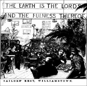 Mission to Seafarers Victoria
Print - Engraving, Sailors' Rest, Williamstown, 31 October 1878
The Sailors' Rest, located in Ann Street, Williamstown opened on 24 May 1878. An article dating 25 May 1878, in the Williamstown Chronicle, describes the interior of the renovated Wesleyan chuch as depicted on the print: "Inside the building the carpenters and painters have been busily engaged. It has been painted throughout, the lower part of the walls be ing stained blue. There is a form all round the building with tables up the sides, and a number of small round tables are scattered about the roomi. In the centre is a splendid wire stand for pot plants, of which there is a grand display. Pictures adorn, the walls; singing birds warble their sweet strains ; and the silent gold fish of which there are several globes add to the beauty of the display. At the east end of the room is the bar, occupying one corner, while in the other are the shelves which accommodate the books of the Library, while last evening across the end wall was in large illuminated letters-'" The earth is the Lord's and the fulness thereof." On the platform are a piano and harmonium. The room is very presentable whether in day light or illuminated vith gas." Eva Carmichael, one of the two survivors of the Loch Art tragedy, visited here on 19 July 1878. She had stayed with Mr and Mrs Gibson and travelled from Camperdown to Melbourne (15 July 1878) to sail back to Ireland. Article in the Leader, 20 July 1878, Page 19: "The Saitors' Rest at Williamstown was yesterday visited by Miss Carmichael, Mr. T. Pearce and Mr. and Mrs. Gibson. The objects of the institution were explained to them, and after a brief stay they complimented the committee on their arrangement. The attendance has ho largely increased that the receipts now average £80 per month. The print is a rare insight of the Sailors' Rest in Williamstown, depicitng the room filled with plants, birds in cages, the seamen enjoying some board games, and coffee.Illustration depicting the interios of the Williamstown Sailors' Rest in 1878 with decoration (plants, paintings, birds in cages), and sailors at tables busy playing chess, talking, having a drink.sailors' rest, williamstown, 1878, plants, books, library, tables, sailors, games, chess, coffee, seamen, sir william stawell, hugh ronald reid -
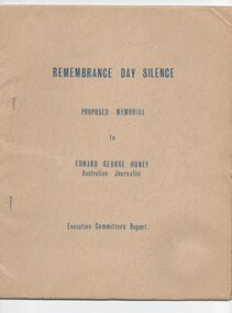 Melbourne Legacy
Booklet - Document, Remembrance Day Silence : Proposed Memorial to Edward George Honey, Australian Journalist. Executives Committee's Report, 1964
An interesting document outlining the evolution of the tradition of pausing in silence for remembrance on 11 November each year. The account outlines how King George V decreed a two minute silence be held at the first anniversary of the Armistice - originally referred to as Peace Day. The events included a letter written by Edward George Honey, an Australian journalist, proposing the idea on 8 May 1919. In it part of it says: "Should not this be the spirit of at least a fragment of our Peace Day? Communion with the Glorious Dead who won us Peace, and from the communion new strength, hope and faith in the morrow, Church services, too, if you will, but in the street, the home, the theatre, anywhere, indeed, where Englishmen and their women chance to be, surely this five minutes of bitter-sweet silence there will be service enough. Before and afterwards, sing and make merry as we will. Of one thing, I am quite certain, and the tis that our songs will take a deeper, truer note after those five minutes of remembrance We will have gathered from them strength for the morrow. God knows we need it!" The document was produced by a committee that was proposing a memorial to Edward Honey to record his role. It was forwarded too H.G. Brain, presumably a Legatee who could bring this information to Legacy's attention. Items were in an envelope with other photos and programmes from different items relating to the Shrine of Remembrance - including discussions on its location and design. Labelled 'Shrine of Remembrance S1 - S14' it was part of an old archive numbering system, that showed there has been efforts in the past to collect, order and save items of Legacy's history. (01181 - 01190, 01206 - 01212).A record of a committee approaching Legacy about a memorial to the man who suggested the adoption of silence as a form of remembrance in 1919. Also there was an effort to record historical events by the "Archive Committee" which collected this and other documents relating to the Shrine together in a file (see items 01181 - 01190, 01206 - 01212)A thirteen page report typed on buff paper in a dark brown card cover, on a proposed memorial to Edward Honey. Also a letter dated 20 March 1964 from the Memorial Committee to Mr H G Brain that accompanied the report.Handwritten 'S13' in red pen on top left of of the letter which is signed Roy Gordon in blue ink. memorial, remembrance day -
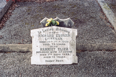
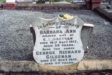
 Eltham District Historical Society Inc
Photograph, Peter Pidgeon, Gilsenan family graves, Eltham Cemetery, Victoria, 5 April 2021
Richard Gilsenan was a retired schoolteacher living at “Rosebank” in Eltham, now the site of the Living and Learning Centre. In 1906, Eltham Primary School’s headmaster John Brown died, and Richard was brought out of retirement (briefly) to be acting headmaster. His son Harold was a junior teacher there at the time. Thereafter, Richard was Secretary of the Eltham Progress League and more importantly was a magistrate at the Eltham Court of Petty Sessions. Cases commonly brought before him included not sending a child to school (typical fine 5/- or eight hours in the lock-up), not having a child vaccinated (fixed fine 40/-), stealing fruit from an orchard, selling liquor out of hours, and offensive language and behaviour. Other miscellaneous cases were allowing cattle to wander, selling cigarettes to a minor, carelessly burning off rubbish on a hot windy day, dumping a dead horse in the Diamond Creek, and youths throwing ripe fruit at passers-by. Richard died in 1920 and is buried in Eltham Cemetery with his wife Harriet Eliza. In mourning his passing, his peers noted that his decisions had been given in a very fair way. Incidentally, his son Harold (the teacher) died in 1921 after being trampled by a horse while en route from Eltham to Cathkin (his then school). In Loving Memory Of Richard Edward Gilsenan Died 30th July 1920 Aged 73 years Also Harriet Eliza Beloved wife of above Died 7th Sept. 1933 Aged 78 years Sweet Rest And In Loving Memory Of Barbara Ann Beloved wide of G. R. Gilsenan Died 18th Sept. 1917 Aged 38 years Also the above George Richard Gilsenan Died 2nd Nov. 1918 Aged 40 yearsBorn Digitaleltham cemetery, gravestones, barbara ann gilsenan, george richard gilsenan, harriet eliza gilsenan, richard edward gilsenan -
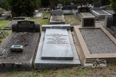 Eltham District Historical Society Inc
Photograph, Peter Pidgeon, Grave of John Arthur and Grace Mitchell, Eltham Cemetery, Victoria, 5 April 2021
Grace Mitchell, a talented artist in later life and baker, managed a pastry shop business near the corner of Mount Pleasant and Main roads, Eltham in the 1950s. Shortly after her marriage to Arthur Mitchell in 1948, Arthur incurred a head injury from an accident and was unable to work. Grace realised she needed to be home to care for her husband as well as earn an income. She managed the bureaucracy of council permits, and made modifications to her home with savings to get the business off the ground without having to borrow money. Grace and Arthur were avid gardeners and would grow, wash and mince vegetables for pasties while Grace handmade and rolled the pastry. They cooked and minced their own meat for the pies and the fruit for the sweet pies came from their orchard at the rear of the property. She also baked scones and cakes. With weekend visitors travelling to Eltham on the train for days trips, her reputation grew as the spot for afternoon tea. Grace’s daughter Jenni mentions the visit of dancer, Robert Helpmann and U.S. actress Katherine Hepburn in her Grace Mitchell: a short history [2012]. Reminiscences in We did open a school in Little Eltham: Eltham Primary School 209, 1856-2006 a history [2006] include a mention of Grace’s famous pastry shop and the Sunday afternoon visit by Helpmann and Hepburn. Grace operated her pastry shop for over 16 years. She supported the Shillinglaw Cottage Preservation Campaign to preserve the cottage through its Flavour of Eltham community cookbook published in 1964 and hosted cooking classes in the new Living and Learning Centre. Grace Mitchell passed away aged 95 years in 2011. In memory of John Arthur Mitchell 1905 – 1975 And Grace Mitchell 1916 – 2011 Loving parents of Jennifer MitchellBorn Digitaleltham cemetery, gravestones, grace mitchell, john arthur mitchell -
 Eltham District Historical Society Inc
Negative - Photograph, Harry Gilham, Grave of Richard Edward Gilsenan and his wife, Harriet Eliza, Eltham Cemetery, Victoria, 1 Aug 2007
Richard Gilsenan was a retired schoolteacher living at “Rosebank” in Eltham, now the site of the Living and Learning Centre. In 1906, Eltham Primary School’s headmaster John Brown died, and Richard was brought out of retirement (briefly) to be acting headmaster. His son Harold was a junior teacher there at the time. Thereafter, Richard was Secretary of the Eltham Progress League and more importantly was a magistrate at the Eltham Court of Petty Sessions. Cases commonly brought before him included not sending a child to school (typical fine 5/- or eight hours in the lock-up), not having a child vaccinated (fixed fine 40/-), stealing fruit from an orchard, selling liquor out of hours, and offensive language and behaviour. Other miscellaneous cases were allowing cattle to wander, selling cigarettes to a minor, carelessly burning off rubbish on a hot windy day, dumping a dead horse in the Diamond Creek, and youths throwing ripe fruit at passers-by. Richard died in 1920 and is buried in Eltham Cemetery with his wife Harriet Eliza. In mourning his passing, his peers noted that his decisions had been given in a very fair way. Incidentally, his son Harold (the teacher) died in 1921 after being trampled by a horse while en route from Eltham to Cathkin (his then school). In Loving Memory Of Richard Edward Gilsenan Died 30th July 1920 Aged 73 years Also Harriet Eliza Beloved wife of above Died 7th Sept. 1933 Aged 78 years Sweet Rest And In Loving Memory Of Barbara Ann Beloved wide of G. R. Gilsenan Died 18th Sept. 1917 Aged 38 years Also the above George Richard Gilsenan Died 2nd Nov. 1918 Aged 40 yearseltham cemetery, gravestones, memorials, barbara ann gilsenan, george richard gilsenan, harriet eliza gilsenan, richard edward gilsenan -
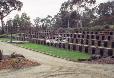 Eltham District Historical Society Inc
Negative - Photograph, Harry Gilham, Terrace Wall Section, Eltham Cemetery, Mount Pleasant Road, Eltham, 1 Aug 2007
Richard Gilsenan was a retired schoolteacher living at “Rosebank” in Eltham, now the site of the Living and Learning Centre. In 1906, Eltham Primary School’s headmaster John Brown died, and Richard was brought out of retirement (briefly) to be acting headmaster. His son Harold was a junior teacher there at the time. Thereafter, Richard was Secretary of the Eltham Progress League and more importantly was a magistrate at the Eltham Court of Petty Sessions. Cases commonly brought before him included not sending a child to school (typical fine 5/- or eight hours in the lock-up), not having a child vaccinated (fixed fine 40/-), stealing fruit from an orchard, selling liquor out of hours, and offensive language and behaviour. Other miscellaneous cases were allowing cattle to wander, selling cigarettes to a minor, carelessly burning off rubbish on a hot windy day, dumping a dead horse in the Diamond Creek, and youths throwing ripe fruit at passers-by. Richard died in 1920 and is buried in Eltham Cemetery with his wife Harriet Eliza. In mourning his passing, his peers noted that his decisions had been given in a very fair way. Incidentally, his son Harold (the teacher) died in 1921 after being trampled by a horse while en route from Eltham to Cathkin (his then school). In Loving Memory Of Richard Edward Gilsenan Died 30th July 1920 Aged 73 years Also Harriet Eliza Beloved wife of above Died 7th Sept. 1933 Aged 78 years Sweet Rest And In Loving Memory Of Barbara Ann Beloved wide of G. R. Gilsenan Died 18th Sept. 1917 Aged 38 years Also the above George Richard Gilsenan Died 2nd Nov. 1918 Aged 40 yearseltham cemetery, gravestones, memorials -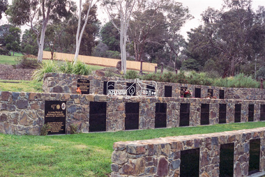
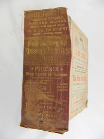 Kiewa Valley Historical Society
Book - Reference Melbourne Directory, Melbourne and Suburban Directory for 1889, Circa 1889
This Directory of 1889 covers the location of Melbourne based trade and professional offices by street and in Alphabetical order. It covers all of Melbourne and its suburbs. It also covers government and official, ecclesiastic, legal, municipal and miscellaneous information. The directory details a cross section of a developing city with a splattering of advertisements opening up an in depth look of all aspects of living in the late 1800s. It is interesting to see that all the advertisements do not have any telecommunication numbers listed (personal shoppers or mail orders only). This was a period of high moral standing within the community and hotels advertised rooms " suites of rooms for families and single rooms for Ladies and Gentlemen" also "electric bells throughout the house. Telephone, night porter and hot and cold baths."This directory would be used by the majority of families and businesses working and living within the Kiewa Valley and the surrounding area. Melbourne was the only place where every aspect of living requirement was catered for. Although the delivery of services and goods were not at a high rate, certain items or transactions would require a visit to "the big smoke". Business information are listed both by suburb and alphabetically. There is also a section for British and Foreign Trade. This directory covered nearly everything to do with commerce, an example pay days for principle firms. Greater evolution of trade locations started to balloon out after the mid 1950's. Increased populations and greater levels of communication and safe fast transport facilities permitted greater devolution of commercial enterprises into rural communities, such as the Kiewa Valley.This directory has no front or back cover and is held together by its cloth spine. It contains over 1300 pages, however there may be some pages missing front and back of the directory which would have contained advertisements of some unknown shops. All the sides of this directory (except the spine) have advertisements and content information stamped on. The spine cover has been placed in the directory until further conservation work is carried out. It has gold coloured printing and in the central section, a gold coloured background with the words "Sands & McDougall's Melbourne Directory 1889." The spine has three adverts on the spine.On the spine in gold colour "South * British insurance Company Fire and Marine. Risks Lowest Current Rates No. 11 Queen Street, Arthur J Masters, Manager" and half way down " *Phoenix* Fire Office of London established over 100 years Annual Income exceeds (pound sign) 1,000,000" underneath "Losses Paid Over (pound sign) 16,000,000" underneath "Reserve Fund Exceeds (pound sign) 1,000,000" underneath "9 Market Buildings William Street, Melbourne " underneath " R. Manfield Taylor, Agent" and at the bottom section" Henry Scott Auctioneer and Estate Agent 49 Bridport St., Albert Park" stamped on the bottom side across the page endings "The Wonderful Wertheim Sewing Machines Swanston Street opposite Town Hall", stamped on the top side across the page endings " The Sweet Hapsburg Pianos & Organs Swanston Street Opposite Town Hall"state government listings, names and location of early melbourne population business names, 1889 members of the victorian executive council -
 Eltham District Historical Society Inc
Photograph - Digital Photograph, Alan King, Pauline Toner Butterfly Reserve, 2008
One of seven sites in Eltham and Greensborough where the butterfly survives. Published: Nillumbik Now and Then / Marguerite Marshall 2008; photographs Alan King with Marguerite Marshall.; p181 The rare Eltham Copper Butterfly, Paralucia pyro-discus, was saved from near extinction by a community campaign in the late 1980s. Thanks to that effort, the butterfly, a form of the Fiery Copper Butterfly, with a wing span of only 2.5cm, can be seen in parts of Eltham and Greensborough from late November to April. As late as 1987 the butterfly was thought to be near extinction. But that year, entomologist, Michael Braby, found several colonies, including two major ones in natural bushland on Diosma Road, Eltham. However these were threatened with destruction, as their habitat was to be destroyed by a development of 71 houses. The colonies were on a 14 hectare subdivision owned by Esanda Finance, an ANZ Bank subsidiary. It would cost around $5 million, to reimburse the bank for the land. The butterfly, which depends on woodland, a stunted form of the Sweet Bursaria bush, and the Notoncus ant, was considered too fragile to relocate. Braby’s discovery led to a sometimes fiery two-year campaign, which even became an election issue. It involved the local community, local and state governments and the developer, before a compromise was reached. The larvae have an intricate relationship with the small black ant, Notoncus. During the day, the larvae shelter in nests made by the ants around the base of the trunk and roots of the Sweet Bursaria (Bursaria spinosa). The ants are thought to protect the larvae from predators and parasites, as they attend them from the nests to feed on the Bursaria leaves at night. In return, the larvae excrete a sugar solution, which the ants love to eat. The butterfly was first recorded in Victoria in 1893, and first collected scientifically from Eltham in 1931. But it was only officially named in 1951, by Victoria’s then top butterfly expert, David Crosby.2 However, from 1970, rapid housing development in Eltham destroyed much of the butterfly’s habitat. The discovery of several major colonies in 1987 met with great excitement, and 250 people attended the first local public meeting. The State Government commissioned Crosby to investigate how to protect the butterfly, and the council froze development for three weeks. Then Esanda agreed to suspend development for several months, until a compromise was reached. Crosby recommended that 62 of the 71 lots be kept to ensure the butterflys’ survival. However this would cost $1 million to $1.5million in compensation to Esanda. Greensborough MP Pauline Toner, launched a $1million fundraising campaign and many artists donated their works to the appeal. Toner offered Clifton Pugh’s painting Eltham Copper Country to millionaire Alan Bond for $1 million, after having heard that he had offered $6 million for the Van Gough painting Sunflowers. However Bond did not accept. The butterfly was considered a ‘hot’ election issue during the by-election, following Pauline Toner’s resignation. Liberal party candidate, Margaret Brown, was accused of falsely saying she had been involved in the butterfly campaign so as to win votes. Sadly, the $1million appeal fell short at $426,000, so a compromise was reached. The State Government donated the Education Department site on Eucalyptus Road, but only nine lots of the Diosma site were bought, and the rest of the development went ahead. On March 3, 1989, Ms Toner died. Thee Eucalyptus Road site was named in her honour. Around 2000 the butterfly was further threatened by proposed developments on Pitt Street, facing the Pauline Toner Reserve and between Diosma and Nyora Roads. Fortunately the Friends of the ECB, with the Shire of Nillumbik, ensured that more habitat was made available. The butterfly now survives in seven sites in Eltham and Greensborough, including the main sites at the Pauline Toner Reserve on Eucalyptus Road, the Western and Eastern colonies on Diosma Road, and the Yandell Reserve in Greensborough.5 The butterfly survives also in Castlemaine and in the Kiata and Salisbury areas. However, it remains endangered.This collection of almost 130 photos about places and people within the Shire of Nillumbik, an urban and rural municipality in Melbourne's north, contributes to an understanding of the history of the Shire. Published in 2008 immediately prior to the Black Saturday bushfires of February 7, 2009, it documents sites that were impacted, and in some cases destroyed by the fires. It includes photographs taken especially for the publication, creating a unique time capsule representing the Shire in the early 21st century. It remains the most recent comprehenesive publication devoted to the Shire's history connecting local residents to the past. nillumbik now and then (marshall-king) collection, eltham copper butterfly, pauline toner butterfly reserve -
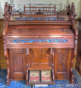 Flagstaff Hill Maritime Museum and Village
Instrument - Organ and stool, 1897-1901
This chapel organ, or pump organ, was made by the Packard Company of Fort Wayne, USA. It was purchased locally from John Broadwood Shepherd & Son of Liebig St, Warrnambool. The donor advised that it was played for many years in the Winslow Presbyterian Church, southwestern Victoria (on Caramut Road, now a private residence). The serial number of the organ dates to be no older than 1887 and no younger than 1901, according to The Pump Organ Society. The goals of The Packard Company, as quoted from the Fort Wayne Gazette, 6th August 1873 are summarised as such; “In the first place, it was determined to make an organ which should be excelled by none. …. It is interesting to the uninitiated to watch the different processes which literally convert the trees of the forest into the marvellous instruments which sound the praises of God in thousands of churches and Sabbath Schools, or make sweet music in multitudes of homes.” The music store of John Broadwood Shepherd and Son had an “impressive” stand at The Great Warrnambool Exhibition of 1896 – 1897 and received a medal for its exhibit. It was also involved in the community, sponsoring prizes for the Musical and Recital Competition, which was part of the entertainment for the Exhibition. The “Warrnambool Standard” newspaper has reference to John Broadwood Shepherd and Son in a newspaper of 1887 and another dated April 13, 1901. A brief history of the Packard Company: 1850, Isaac T. Packard joined with Nelson J. Foss and Calvin Hatch to form Packard, Foss, & Co., manufacturing reed organs, seraphines, and melodeons 1871 the Fort Wayne Organ Company was formed, and Isaac Packard has 40 shares. 1872 the first organ was completed 5th Sept 1899, “Fort Wayne Organ Company” was officially changed to “The Packard Company” 1908 – 1914 (different dates given) the Packard Company ceased producing organs and specialised in pianos. 1930 company went into receivership 1935 the city of Fort Wayne acquired the former Packard Company property, tore the buildings down and turned it into a park, now known as Packard Park. The organ is significant to local history for being sold by a Warrnambool business and played at a local chape or church. It represents community and religious life in late Victorian times.Chapel organ or pump organ (with stool), dated not before 1897 and not after 1901. Medium brown timber with fretwork and turned spindles, Manufactured by Packard, Fort Wayne U.S.A. Organ was purchased from John Broadwood Shepherd & Son, Liebig St, Warrnambool. Serial number is stamped into the wood, rear of organ. lower right panel. Pedals are covered in carpet and each has the maker's name on the lower part of the pedal frame. The keyboard has five octaves and twelve stoppers.Words on front panel “Packard Organ / Fort Wayne Ind. U.S.A. / JOHN BORADWOOD SHEPHERD & SON, / LIEBIG STREET, WARRNAMBOOL.” Serial Number "48870"flagstaff hill, warrnambool, shipwreck coast, flagstaff hill maritime village, flagstaff hill maritime museum, maritime museum, great ocean road, pump organ, packard organ, fort wayne usa, john broadwood shepherd & son, john broadwood, winslow victoria, church music, musical instrument, john broadwood shepherd and son, presbyterian church, winslow presbyterian church, the great warrnambool exhibition 1896-1897 -
Bendigo Historical Society Inc.
Document - THE BENDIGO CHORAL SOCIETY, 10 December 1918
The Bendigo Choral Society, Season 1918-Third Concert. Seventh Grand Concert, Masonic Hall, December 10th, 8pm. Artists: Miss Phillis Hannaford,L.A.B., Miss Claire Colgan, Miss Beryl Leggo L.A.B., Mr Gerson Krost. Conductor: Mr W C Frasier, A.R.C.O. Pianiste: Miss Muriel Hyett, L.A.B. Admission 1/- and 1d. Tax Patron: His Worship the Mayor, Ambrose Dunstan. Office bearers: President-mr H M Leggo. Vice Presidents-Mr M G Giudice & Cr J H Curnow. Sub Conductor-Mr E A Miller. Treasurer- Mr W H Dolpin. Lobrarian-Mr R J Duguid. Assistant Librarians-Messrs W B & G L M'Coy. Assistant Secretary-Mr F A Wittscheibe. Committiee-Office Bearers- Mesdames Perry & Scott, Misses Colgan, Veale, Gall and Weeks and Messers Duguid, Sleeman, W Brown, F Witscheibe and F J Walter. Executive O fficer-Messers Frank Wittscheibe and H Walker. Hon. Secretary- J Hudspeth, 85 Wills Street, Bendigo. Programme: God Save the King, Lift up your Heads, Nocturne op.9, No. 2, Inflammatus, Ballade in A, With Verdure Clad, Sanctus, Liberty, O Lieb, Danse Negre, Sweet and Low, Shadow Song, Air for G String, Hallelujah. Season 1919 Subscriptions. For the Season 1919, subscribers of 1 pound/1/- will be entitled to reseved seats for each Concert. Those subscribing more than one guinea will be entitled to two seats for each subscribed. Performing members who subscribe 10/6 for the Society (in addition to their membership fee) shall be entitled to 2 reserved seats for each Concert.Bolton Bros, Printers, Bendigoprogram, music, the bendigo choral society, the bendigo choral society season 1918 third concert seventh grand concert artists committee members programme -
 Flagstaff Hill Maritime Museum and Village
Domestic object - Pudding Mould
One of the first documented mentions of pudding can be found in Homer's Odyssey where a blood pudding roasted in a pig's stomach is described. This original meaning of a pudding as a sausage is retained in black pudding, which is a blood sausage originating in the United Kingdom and Ireland made from pork or beef blood, with pork fat or beef suet, and a cereal. Another early documented recipe for pudding is a reference to asida, found in a tenth century Arabic cookbook by Ibn Sayyar al-Warraq called Kitab al-Ṭabīḫ (Arabic: كتاب الطبيخ, The Book of Dishes). It was described as a thick pudding of dates cooked with clarified butter (samn). A recipe for asida was also mentioned in an anonymous Hispano-Muslim cookbook dating to the 13th century. In the 13th and 14th centuries, in the mountainous region of the Rif along the Mediterranean coast of Morocco, flour made from lightly grilled barley was used in place of wheat flour. A recipe for asida that adds argan seed oil was documented by Leo Africanus (c. 1465–1550), the Arab explorer known as Hasan al-Wazan in the Arab world. According to the French scholar Maxime Rodinson, asida were typical foods among the Bedouin of pre-Islamic and, probably, later times. In the United Kingdom and some of the Commonwealth countries, the word pudding can be used to describe both sweet and savoury dishes. Unless qualified, however, the term in everyday usage typically denotes a dessert; in the United Kingdom, pudding is used as a synonym for a dessert course. Puddings had their 'real heyday...', according to food historian Annie Gray, '...from the seventeenth century onward'. It is argued that 'the future of the boiled suet pudding as one of England's national dishes was assured only when the pudding cloth came into use' and although puddings boiled in cloths may have been mentioned in the medieval era, one of the earliest mentions is in 1617 in a recipe for Cambridge pudding, a pudding cloth is indicated; 'throw your pudding in, being tied in a fair cloth; when it is boiled enough, cut it in the midst, and so serve it in'. The pudding cloth is said, according to food historian C. Anne Wilson, to have revolutionised puddings. 'The invention of the pudding-cloth or bag finally severed the link between puddings and animal guts. Puddings could now be made at any time, and they became a regular part of the daily fare of almost all classes. Recipes for them proliferated.' https://en.wikipedia.org/wiki/PuddingPuddings and pudding making have evolved over the years, and continue to do so. White ceramic pudding bowl with fluted decoration on the outside.flagstaff hill, warrnambool, shipwrecked-coast, flagstaff-hill, flagstaff-hill-maritime-museum, maritime-museum, shipwreck-coast, flagstaff-hill-maritime-village, puddings, ceramics -
 National Wool Museum
Throw, 2017
Anlaby’s sheep are born, bred and shorn at their farm located in South Australia. The wool is then scoured at Michels in Adelaide, combed and turned into Tops at Cashmere Connections in Bacchus Marsh, and then Spun and Woven at a historic mill in Scotland named Johnstons of Elgin. Sewing is completed by artisan seamstresses and packaging is from a local Adelaide family business. Established in 1839 just North of the Barossa Valley in South Australia, Anlaby is the oldest continuing merino sheep stud on mainland Australia. Fredrick Dutton employed Alexander Buchannan to bring sheep to the buoyant market in Adelaide from Goulburn NSW. Several others speculated on possible successes, including Buchannan and a flock of 18,000 sheep were walked overland. The trek took nine months. During this time the Adelaide market prices had collapsed. Having found land with a spring of sweet water, Dutton decided to keep his flock of 5,000 stud sheep and purchased a small parcel of land that is now called Anlaby. The property prospered and Buchannan was employed as manager for the next 25 years. At its height Anlaby covered 250sq miles – 160,000 acres and employed 70 men. The first bale of wool from South Australia to be auctioned in London came from Anlaby. The Anlaby stud also provided the foundation ewes for the well-known Bungaree merino stud in 1841. With prosperity came a large house and gardens for Buchannan in 1861. Anlaby was inherited by Henry Dutton from his uncle in 1895. Squire Dutton, as he was known, continued to grow the family’s fortunes and spent his money expanding the grand home and creating a magnificent 10-acre garden. Today the Anlaby merino stud continues and both the house and garden are undergoing significant restorations. Wool continues to be one of the most important elements at Anlaby. It was the source of great wealth in the past and is now directly tied into Anlaby’s future. Anlaby makes beautiful woollen scarves, lady’s wraps, exquisite throws and small range of baby blankets. From the moment a lamb is conceived and through its entire lifecycle Anlaby look after nutrition and quality of life. Twice a year the sheep are shorn and the wool using minimal treatment is washed, combed, spun and woven into the Anlaby product range. This attention to detail results in the buttery softness distinctive of the exclusive woollen range.Throw came with packaging and information card which reads ANLABY in large capital lettering at the top and bottom of either side of card. Throw is white with green edging of 15cm on two edges. Within this edging is the sewing of a tree in white.Wording: ANLABY Pure Anlaby Merino Wool Oldest merino stud on mainland Australia Made in Australia Card. Wording: ANLABY Certificate of Authentication THIS CERTIFICATE AUTHENTICATES THE PRODUCT TO BE 100% AUSTRALIAN AND MADE FROM PURE MERINO WOOL PRODUCED EXCLUSIVELY AT THE ANLABY MERINO STUD IN SOUTH AUSTRALIA THE ANLABY FLOCK (REGISTERED NUMBER 102) IS THE OLDEST CONTINUOSLY OPERATING MERINO STUD IN MAINLAND AUSTRALIA. THE MERINO FLOCK AT ANLABY MAINTAINS A GENETIC LINE STARTED IN 1839 THIS PRODUCT IS PART OF THE LIMMITED EDITION RANGE PRODUCED AT ANLABY. IN 2014 WE CELEBRATED ANLABY’S 175TH ANNIVERSAY ANLABY Reverse. Wording: ANLABY PURE NATURAL WOOL THE SHEEP GRAZE AMONGST THE GUM TREES ON THE ROLLING HILLS OF ANLABY. ANLABY SHEEP ARE CHARACTERISTICALLY BIG BODDIED AND BRED TO FLOURISH IN THE WARM AUSTRALIAN CLIMATE. OUR WOOL IS MINIMALLY TREATED AND THE PRODUCTS ARE MADE IN SMALL RUNS UNDER THE PERSONAL SUPERVISION OF THE OWNERS. WE BELIEVE IN SUSTAINABLE AND RESPONSIBLE FARMING AND MILLING PRACTICES. THE ATTENTION TO DETAIL RESULTS IN THE BUTTERY SOFTNESS DISTINCTIVE OF THIS EXCLUSIVE WOOLLEN PRODUCT. WITH CARE THIS IS A TREASURED ITEM FOR THE NEXT GENERATION. ANLABY www.anlaby.com.auwool, merino sheep, south australia, wool processing, wool processing textile finishing -
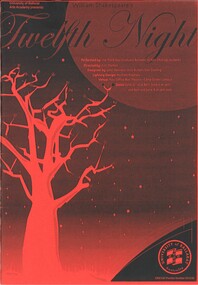 Federation University Historical Collection
Programme, Twelfth Night, 2006
This is the program for a University of Ballarat Performing Arts presentation of Twelfth Night by William Shakespeare, in 2006, performed by third year Graduate Bachelor of Arts (Acting) students. Director: Kim Durban; Design: John Bennett, Loris Button, Dan Cooling; Lighting Design: Michele Preshaw. The venue was Post Office Box Theatre, Camp Street Ballarat. Dates: June 14 16 at 8pm; June 17 at 2pm and 8pm and June 18th at 5pm. Kim Durban initially trained as a teacher in South Australia, then as a director at the Victorian College of the Arts in Melbourne.In 1990 Kim was awarded the Ewa Czajor Memorial Award for study in Europe. She was the recipient of an Australia Council Training Artistic Directors grant , working Artisiic Associate at Playbox 1994-95. During her Masters studies she received the Yvonne Taylor Award for Directors. In 2001 , Kim was appointed Senior Lecturer in Performing Arts at the University of Ballarat where her productions have included The White Rose, Sweet Charity, 42nd Street, Chekhov in Black and White, A Midsummer Night's Dream, The Night Before The Day After Tomorrow, Kiss Me Kate, All's Well That Ends Well, Richard the Third and On the Town. Synopsis: Sebastian and Viola are twins who are shipwrecked. Separately they find their way to the land of Illyria, both believing that the other had perished. Viola dresses herself as a boy (called Cesario) and enters the service of Count Orsino who asks 'him' to woo Olivia on his behalf. However Olivia falls for Cesario who has fallen in love with Orsino. A subplot involves two drunken knights, Sir Toby and Sir Andrew, a self important steward, Malvolio, a clown , a forged letter and a pair of yellow stockings. The back page of the program shows an advertisement for a performance of Eugene Iomesco's "The Killing Game"; Director Greg Stone, presented by The University of Ballarat Arts Academy for November, 2006, at The Theatreworks. Eugene Iomesco (1909-1994) was a Romanian born French playwright. The program also contains a promotion for a performance titled "Telling Tales An Evening of Subterfuge and Intrigue" presented by Ballarat National Theatre, to be held in June/July 2006 at the Courthouse Theatre. This comprises of three pieces- 'In by the half'; 'Three at a Table 'and 'Dead Frank'. The cast includes Lynne Birkelund, Brendon Clarke, Jez Constable, Lesley Hale, Katrina Hill, Gabrielle Leeds, Mary-Rose McLaren, Alisha Ryan, and Peppa Sindar.Fourteen page booklet containing information about three plays: 'Twelfth Night'; 'The Killing Game' and Telling Tales "An Evening of Subterfuge and Intrigue". Program contents for Twelfth Night: Cast: Synopsis; Director; Guest Artist; Performers; Artistic Team and Production Team. The front cover has the outline of a red tree on a black starlit sky. The back cover is black and red and is advertising a coming production in November, 2006, 'the Killing game.twelfth night, university of ballarat performing arts academy, john bennett, loris button, dan cooling, michele preshaw, post office box theatre, shakespeare, william shakespeare, kim durban, the killing game, greg stone, theatreworks, eugene ionesco, telling tales, lynne birkelund, brendon clarke, jez constable, lesley hale, katrina hill, gabrielle leeds, mary-rose mclaren, alisha ryan, peppa sindar -
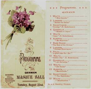 Bendigo Historical Society Inc.
Programme - Programme for German Masque Ball, 1905
Two cardboard parts to a printed programme. On one is a posy of violets and the printing: "Programme German Masque Ball, Tuesday 22nd. The second lists 15 dances. Printed by A. Brookley, Printers. Also are the following two articles from Trove: From the Bendigo Advertiser and the Bendigo Independant, Wed 23 Aug 1905: GERMAN MASQUE BALL. The pleasant plan of fancy masque ball, which for nearly 20 years now has been an annual fixture at this season, is always looked forward to with delight. It is got up by the Bendigo Deutcher Verein, in aid of their free library. The function took place last night in the Masonic Hall and was most enjoyable, and all who took part in it were delighted. The hall was tastefully decorated with flags, flowers and ferns. Bockelmann's Band occupied the stage and discoured sweet music. Many of the items on a long programme were of Mr. Bockelmann's own composition, notably the schottische "Bendigo," the waltz 'Como, 'and the waltz "Golden City." By 9 o'clock there were about 80 couples on the floor. Amongst the merry troupe of dancers were youths and maidens in all sorts and descriptions of gay costumes, including flower girls, Japanese lady, German peasant, lily of the valley, Mercia, Geisha girl, French Vivandiere, red dominos, black dominos, "The Last Rose of Summer," rose, sailor girls, gondolier, Pierot, Charles II., Tipperary boy. Toreador, Romeo, Prince Le Var, huntsman, Indian prince, fireman, barristers. jockeys, cricketers, etc. Many of the Iadies were in evening dress, but wore the masque. The arrangements were admirably carried out by the secretarv. Mr. J. D. Khaland, while it would be difficult to find a better M.C. than Mr. J. Armstrong. The dancing was witnessed by a large number of the public, who were accommodated on a temporary gallery at one end of the hall. A small charge was made for their admission, which helped to swell thelibrary funds. An excellent supper, served in Mr. W. C. Dick's best style, was much enjoyed. Dancing was kept up till about three o'clock, everybody pronouncing the gathering a highly enjoyable one. bendigo history, sandhurst, lutheran german church, penny school -
Coal Creek Community Park & Museum
Music Sheets
A selection of 36 music sheets. Numbers against each song title has been written by the original owner. 1 - Ginger Headed Feller 2 - Dreamy Hawaiian Moon 3 - Small Fry 4 - A Little Kiss At Twilight 7 - Musical Comedy Favourites Pt 1 & 2 9 - Moonlight in Waikiki 12 - You're Pretty as a Picture / My Own 19 - Sweethearts and Wooden Shoes (2 Copies) 20 - One Day When We Were Young 24 - Who Do You Think You Saw Last Night? / You're Lovely Madam 25 - Thanks For Everything / I Found My Yellow Basket 27 - Josephine / I'm Singing a Song for the Old Folks 30 - Romany / The Park Parade 31 - A Song of Old Hawaii / So little Time 83 - A Pretty Girl is like a Melody / You 101 - One Never Knows, Does One / Goodnight My love 103 - Someone to Care For Me / Rainbow on the Rive 105 - Miracles Sometimes Happen / I Want the Whole World to Love You 112 - The Coronation Waltz 116 - Looking Around Corners For You / There's That Look in Your Eyes Again 117 - May I Have The Next Romance With You? / Head Over Heels in Love 118 - Harbour Lights / There's Yoo-hoo in Your Eyes 146 - Its The Natural Thing to Do / The Moon Got In My Eyes 150 - The Little Boy Santa Forgot / Have You Ever Been In Heaven 152 - Where an Old Spanish Town Used To Be / Once In A While 154 - You're a Sweetheart / My Fine Feathered Friend 157 - Sweet Someone / Broadway's Gone Hawaii 158 - Always and Always / A Gypsy Told Me 160 - Got A Pair Of New Shoes / A Serenade to the Stars 161 - Down Where the Trade Winds Blow / Hawaii Calls 163 - More Than Ever / Let's Give love Another Chance 165 - A Foggy Day / Rosalie 166 - Who Are We To Say / Shadows on the Moon 169 - Melody Farm / The One I Love 170 - Moonshine Over Kentucky / An Old Straw Hat 175 - On The Sentimental Side / My Heart is Taking Lessonspencil and blue ink numbering system. -
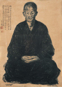 Duldig Studio museum + sculpture garden
Drawing, Karl Duldig, The Buddhist Monk, Guangqia by Karl Duldig 1940, 1940
The Buddhist monk Guangqia visited Karl Duldig’s studio on two consecutive days, in the company of the noted Chinese writer, Professor Yu Dafu, a friend of Karl’s. Karl made two portraits of the monk, the first depicting him sitting, and the second in a standing pose. The portraits were drawn using a Chinese brush and Indian ink. Surviving sketches in the Studio’s collection indicate that Karl thought about creating a life-size sculpture later on, but this was not realised. Guangqia added inscriptions in his own hand to both drawings and stamped them with a red seal. The seated drawing has an inscription in which he quoted from a Buddhist poem, ‘A Contented Mind’ by the scholar Lingfeng of Mt Tiantai. In the summer I went to visit the Austrian sculptor Duldig with Professor Yu Da Fu. My virtue is slight – I cannot accept your offerings and gifts; I am amply rewarded by the clouds and springs. Rather than a table laden with pearl-like rice, I prefer the wind and leaves falling on my bed. Sitting quietly on my meditation cushion Is sweeter than the wheat offered by a thousand families. The pity is that I am gradually growing old; My bitter journey is not worthy of your offerings. The second drawing has a quote from a Buddhist poem on the study of Chán (Zen) Buddhism, by the famed Chán master, Dàjiàn Huìnéng (638–713): The portrait, with its figure positioned on a scroll-like ground and inscription is reminiscent of traditional Zen Buddhist portraiture. In this school of portraiture, which stretched back to at least the thirteenth century, monks were depicted sitting or standing facing the viewer, and typically the monk added an autographic inscription to the portrait. The portraits were often passed from master to disciple, continuing the disciples’ journey of spiritual enlightenment and were revered for their association with remarkable or holy priests. The Buddhist monk, Guangqai who added his inscription and stamp to the drawings would most certainly have been aware of this tradition. It is likely that Karl was aware of this tradition, one of the points where the studio’s collections of art works from Singapore intersect with the earlier Viennese collections can be found in the Library where a catalogue of an exhibition, 'Ausstellung Ostasiatischer Malerie und Graphik' is held. The Viennese Friends of Asian Art and Culture and the Albertina Museum staged this exhibition of East Asian painting and graphic works in 1932. Such was the internationalism of Duldig’s education in Vienna, that adaption to a new environment and culture in the Straits Settlement was swift, and he was able to interpret the artistic traditions of the place, and make them his own. It is part of the strength of the collection, that in many cases contemporary supporting documentation for the works of art is available. In this case there is a photograph of the Monk with Yu Ta-fu, and Karl and Eva Duldig, outside the studio at the time the drawings were made. Ann Carew 2016The portraits of Guangqai have national and international aesthetic significance. The works of art demonstrate the artist’s skill in capturing the physical appearance and demeanour of his subject, and his ability to adapt his working methods to incorporate traditional Asian materials and cultural practices. The portrait is one of few examples in Melbourne of a central European modernist artists working in, and engaging with Asia, during this period and it is culturally and aesthetically significant for this reason. The portraits are also historically interesting in documenting the life and experiences of Karl Duldig in the Straits Settlement (Singapore). Ann Carew 2016Brush drawing in chinese ink on paper. Seated Buddhist Monk. Chinese calligraphy hand written in black ink. Two red stamps under calligraphy.Signed Karl Duldig in l.r. corner. Dated Singapore 1940 in l.l. corner. -
 Eltham District Historical Society Inc
Photograph - Aerial Photograph, Landata, Eltham; Crown Allotment 15, Section 5, Parish of Nillumbik (Stokes Orchard Estate), Dec. 1945
Centred on present day Diosma Rd, Stokes Pl, Nyora Rd and Eucalyptus Rd Historic Aerial Imagery Source: Landata.vic.gov.au Aerial Photo Details: Project No :5 Project : MELBOURNE AND METROPOLITAN AREA PROJECT Run : 36 Frame : 60546 Date : 12/1945 Film Type : B/W Camera : EAG4 Flying Height : 10200 Scale : 6000 Film Number : 195 GDA2020 : 37°42'47"S, 145°09'56"E MGA2020 : 338306, 5824438 (55) Melways : 22 C4 (ed. 42) A History of the Development of Crown Allotment 15, Section 5, Parish of Nillumbik – Stokes Orchard Crown Allotment 15, Section 5, Parish of Nillumbik (CA15) is a square allotment of 158 acres or approximately a quarter of a square mile. It lies just beyond the eastern end of Pitt Street, south of Nyora Road to the northern end of Eucalyptus Road and extends east from Eucalyptus Road to Reynolds Road. The topography of CA15 is generally steep, sloping up to a hill near the centre of the land, the ridgeline passing through the properties along the southern side of Diosma Road. Eucalyptus Road is a straight north-south road with its northern end at the north west corner of CA15. Until the end of the 1970s this road was an un-named Government Road and was largely not open to traffic. With residential development in the 1970s the road was constructed, and the council allocated the name obviously in recognition of the predominant species of the local bushland. CA15 was purchased from the Crown by George D’Arley Boursiquot, a prominent Melbourne printer, on 28th October 1852. On November 23, 1922, former Member for Gippsland and Melbourne Real Estate Agent, Hubert Patrick Keogh purchased the allotment then sold it March 13, 1925, to local farmer, Robert David Taylor, a former Shire of Eltham Councillor (1911-1920) and Shire President (1919). Taylor had extensive land holdings stretching west towards Bible Street and Main Road. The Taylor home was situated at the top of the hill in Bible Street at present day 82 Bible Street. At the time of Taylor’s purchase in 1925, CA15 was subdivided into 48 lots that could be described as small rural properties or large residential lots. A typical lot size was one hectare or 2.5 acres. The subdivision created two roads, Nyora Road, and Diosma Road, each following an irregular alignment between Eucalyptus and Reynolds Roads. However, the lots were not sold off separately nor were the roads constructed. The land effectively remained as one parcel for many further years. Robert David Taylor died November 30, 1934, and probate was granted to his son of the same name, Robert David Taylor of Bible Street, Salesman and William McLelland Vance Taylor of 73 Emmeline Street, Northcote, Clerk, with the transfer of the land into their names on July 8, 1935. Frank Stokes worked as a qualified accountant at Kennons leather factory in Burnley, while living at 1 Thomas Street, Mitcham. He suffered from migraines and wanted to return to working the land (he had previously worked on farms and orchards since coming to Australia from England in 1926, both in WA and Vic.). He first travelled to the district by train in July 1942 to find land with the intention to establish an orchard. By chance he met Arthur Bird of Bird Orchard (bounded by Pitt Street, Eucalyptus Road, and Wattle Grove) and they got talking over their common interest. Arthur put Frank up for the night and pointed out the land, 158 acres- part of the Taylor Estate- £900, Crown Allotment 15, Section 5, Parish of Nillumbik (CA15) somewhat diagonally opposite Bird Orchard. Stokes applied through the Riverina Agency to purchase the land who in turn applied for permission from Canberra to sell as there was a new government regulation introduced during the Second World War banning land sales except for immediate production. Stokes obtained a loan on his Mitcham house of £600 @ 5% and paid £450 deposit with quarterly payments of £15 spread over 5 years. Stokes was assisted and advised by Arthur Bird who farmed the neighbouring orchard. In early 1943 Stokes took possession and would catch the train out to Eltham on Fridays after work and began building a hut on the corner of Nyora Road and the Government Road (Eucalyptus Road) for shelter and to lock up tools. He established an orchard on the central western part of the land through the centre of which ran a natural waterway (part of the present-day linear park) and was able to pay a neighbour (Hawkins) to help with clearing and fencing 25 acres, and with a horse and single furrowed plough, planted approximately 2,500 fruit trees - cherries, peaches, plums, almonds, pears, apricots and lemons as well as a few apples and oranges; a massive task. Aerial photographs from the 1940s through to the 1990s clearly show the orchard with most of the larger CA15 site remaining as natural bushland. A huge problem was hares and rabbits eating all the new buds off the tiny trees. As well as laying poison he painted the trees with a mixture of cow manure and lime, often working by moonlight. Procurement of wire and wire netting was difficult because of the war but after much effort he obtained a permit from the Agricultural Department for supplies in March 1944. In February 1945 Stokes applied for a permit to build a “packing shed” as no house building was allowed. It was to be 33 feet x 21 feet and cost £312. It was constructed mostly from second-hand materials, which were hard to obtain, especially iron for roofing. Stokes finished work at Kennons on October 31, 1945, and in March 1946 he sold the family home at Mitcham for £1,230 plus £170 for furniture. On May 15, 1946, title to the CA15 property was issued to Frank Howard Alfred Stokes, Orchardist and Gladys Ethel Stokes, Married Woman, both of Pitt Street, Eltham. The family of five then moved into the very unfinished “packing shed” at Eltham, which was a struggle to weatherproof. Eventually rooms were divided off and lined with hessian bags and whitewashed. Their income was firewood (cut and sold), selling rockery stones and cut Sweet Bursaria. (It was discovered during the 1940s that Sweet Bursaria contained the sunscreen compound Aesculin. The RAAF utilised this compound from Sweet Bursaria during WW2 for pilots and gunners.) The orchard’s first fruit sale was a half-case of Le Vanq peaches in December 1947 for the price of 8 shillings. In 1956 plans for house were drawn and Glen Iris bricks purchased (1956 Olympic Rings variant). The building of the house commenced in 1957 - 12 feet of original packing shed was removed – and was completed in 1959. Water was connected from newly built pressure storage on the property at the end of 1959 and the electricity connection for the first time at 3pm on April 29, 1960. The house remains to present day (somewhat modified) at 1 Nyora Road, home to Nyora Studio Gallery. On occasions, spare remnants of the 1956 bricks have been known to be unearthed in gardens on the estate as they were utilised by Frank Stokes to fill in rabbit holes. On May 26, 1950, a parcel of land was compulsorily acquired by the Melbourne and Metropolitan Board of Works on the hilltop to establish an easement for a high-level service reservoir to augment Eltham’s water supply. The project also included pipe tracks for the necessary water mains. The reservoir has now been superseded by higher level water tanks east of Reynolds Road and its former site is now a public reserve. On November 27, 1964, the State Electricity Commission served notice to compulsorily acquire a further parcel through the eastern part of the land for a major electricity transmission line that augmented supply from the La Trobe Valley to Melbourne. The easement was registered February 11, 1966. The easement was widened July 18, 1969 for a second transmission line to be constructed. In 1971 Melbourne Metropolitan Planning Scheme amendments adopted Nyora Road as the boundary between a residential zone to the north and a rural zone to the south. This determined the future development of the land. In the mid-1970s the Shire of Eltham divided the orchard into numerous rate-able parcel lots, the 48 lots having been established in 1925 and the subsequent rates assessment proved unsustainable for Stokes. He commenced selling lots outside the boundary of the orchard, north of Diosma and South of Nyora. However shortly later the land between Nyora and Diosma Roads and west of the electricity easement was sold and subdivided into residential lots, a housing development by Macquarie Builders and marketed as the Stokes Orchard Estate. New streets were created, and most were named after trees, although one, Stokes Place, commemorates the former owners. The development was undertaken in two stages; Stage 1 (1975) encompassing Scarlet Ash Court, Ironbark Close and Peppermint Grove bounded by Nyora and Eucalyptus roads and Stage 2 (1978) encompassing Stokes Place, Orchard Way, The Crest and The Lookout bound by Nyora and Diosma roads. The developer, Macquarie Builders went bankrupt shortly after the release of Stage 2 leaving many purchasers to fend for themselves and arrange for their own independent builders. There were also difficulties with sewerage for the land immediately south of Diosma Road and so the conventional residential lots were abandoned in favour of larger lots. The development of Orchard Way, The Crest and The Lookout did not proceed as planned and the proposed lots were incorporated into five-acre parcels instead. These included a low-density group housing development by the Graves family and the award winning Choong House (1983) with Gordon Ford developed garden immediately next door situated on the ridge of the hill nestled amongst the original bush, Eucalypt trees and Sweet Bursaria. In 1994, Nillumbik Shire Council applied Significant Environment and Significant Landscape overlays upon the properties on the south side of Diosma Road to ensure protection of this natural bush garden environment. With the arrival of the sewer along Diosma Road in the 1990s, most of these five-acre parcels have since been subdivided multiple times. The Choong house presently sits on a 2.7-acre property, which in 2022 Nillumbik Council nominated for Cultural Significance Heritage protection and is considered potentially significant at State level. The Stokes family were also associated with the Eltham Christian Church. In the 1970s this church had met in temporary premises in Eltham. Lots of the original 1925 subdivision remained south of Nyora Road and a number of these lots were utilized for the Eltham Christian School, which was established by the Eltham Christian Church in 1981. The school operated on this site until 2000. The premises are now used by The Vine Baptist Church. By the mid-1980s the whole of CA15 had been developed for residential and school purposes, except for the sections north of Diosma Road and between the transmission lines and Reynolds Road. Sewerage issues had been resolved for the section north of Diosma Road and in 1987 it was in the process of being subdivided into residential lots. The development coincided with the discovery of colonies of the rare and endangered Eltham Copper Butterfly on the site. This resulted in a community and political campaign to save the butterfly habitat. With the co-operation of the land developer the subdivision was altered to create two bushland reserves in the critical butterfly habitat areas. In the late 1980s the State Government was investigating options for establishing a metropolitan ring road link between Diamond Creek and Ringwood. The chosen route was adjacent to Reynolds Road and so this created a freeze on development of CA15 between Reynolds Road and the electricity easement. The ring road proposal was eventually abandoned, and this part of the land was subdivided into low density residential lots. Diosma Road has been discontinued at the electricity easement and the eastern part incorporated into View Mount Court with access from Reynolds Road. The whole of CA15 has now been developed for residential or associated purposes, ranging from conventional density to quite low density south of Nyora Road. Some remnants of the orchard remain, a few cherry trees on the Graves property and a lone apple tree in Stokes Place. The butterfly reserves comprise significant areas of remnant bushland. Linear reserves through the estate link with central Eltham via the Woodridge linear reserve and with Research along the electricity easement. CA15 as it exists today has a complicated history of rural use, Government acquisition, urban development, and community action. References: • “Stokes Orchard, an incomplete history”; Russell Yeoman with Doug Orford • Correspondence, Beryl Bradbury (nee Stokes) • Aerial Photographs, 1931-1991, Landata (landata.vic.gov.au) • Certificate of Title, Vol. 4930 Fol. 985900 • Plan Number LP 10859 aerial photo, diosma road, eltham copper butterfly, eucalyptus road, ironbark close, nyora road, peppermint grove, peter & elizabeth pidgeon collection, power transmission lines, reynolds road, scarlet ash court, stokes orchard estate, stokes place, woodridge estate, frank stokes -
 Eltham District Historical Society Inc
Photograph - Aerial Photograph, Landata, Eltham; Crown Allotment 15, Section 5, Parish of Nillumbik (Stokes Orchard Estate), Nov. 1931
Centred over present day Reynolds Road and Mount Pleasant Road, Eltham (including Diosma Rd, Stokes Pl, Nyora Rd and Eucalyptus Rd) Historic Aerial Imagery Source: Landata.vic.gov.au Aerial Photo Details: Project No :1931 Project : MALDON PRISON Run : 21 Frame : 3160 Date : 11/1931 Film Type : B/W Camera : F8 Flying Height : 11000 Scale : 18860 Film Number : 60 GDA2020 : 37°43'31"S, 145°10'20"E MGA2020 : 338912, 5823086 (55) Melways : 22 E8 (ed. 42) A History of the Development of Crown Allotment 15, Section 5, Parish of Nillumbik – Stokes Orchard Crown Allotment 15, Section 5, Parish of Nillumbik (CA15) is a square allotment of 158 acres or approximately a quarter of a square mile. It lies just beyond the eastern end of Pitt Street, south of Nyora Road to the northern end of Eucalyptus Road and extends east from Eucalyptus Road to Reynolds Road. The topography of CA15 is generally steep, sloping up to a hill near the centre of the land, the ridgeline passing through the properties along the southern side of Diosma Road. Eucalyptus Road is a straight north-south road with its northern end at the north west corner of CA15. Until the end of the 1970s this road was an un-named Government Road and was largely not open to traffic. With residential development in the 1970s the road was constructed, and the council allocated the name obviously in recognition of the predominant species of the local bushland. CA15 was purchased from the Crown by George D’Arley Boursiquot, a prominent Melbourne printer, on 28th October 1852. On November 23, 1922, former Member for Gippsland and Melbourne Real Estate Agent, Hubert Patrick Keogh purchased the allotment then sold it March 13, 1925, to local farmer, Robert David Taylor, a former Shire of Eltham Councillor (1911-1920) and Shire President (1919). Taylor had extensive land holdings stretching west towards Bible Street and Main Road. The Taylor home was situated at the top of the hill in Bible Street at present day 82 Bible Street. At the time of Taylor’s purchase in 1925, CA15 was subdivided into 48 lots that could be described as small rural properties or large residential lots. A typical lot size was one hectare or 2.5 acres. The subdivision created two roads, Nyora Road, and Diosma Road, each following an irregular alignment between Eucalyptus and Reynolds Roads. However, the lots were not sold off separately nor were the roads constructed. The land effectively remained as one parcel for many further years. Robert David Taylor died November 30, 1934, and probate was granted to his son of the same name, Robert David Taylor of Bible Street, Salesman and William McLelland Vance Taylor of 73 Emmeline Street, Northcote, Clerk, with the transfer of the land into their names on July 8, 1935. Frank Stokes worked as a qualified accountant at Kennons leather factory in Burnley, while living at 1 Thomas Street, Mitcham. He suffered from migraines and wanted to return to working the land (he had previously worked on farms and orchards since coming to Australia from England in 1926, both in WA and Vic.). He first travelled to the district by train in July 1942 to find land with the intention to establish an orchard. By chance he met Arthur Bird of Bird Orchard (bounded by Pitt Street, Eucalyptus Road, and Wattle Grove) and they got talking over their common interest. Arthur put Frank up for the night and pointed out the land, 158 acres- part of the Taylor Estate- £900, Crown Allotment 15, Section 5, Parish of Nillumbik (CA15) somewhat diagonally opposite Bird Orchard. Stokes applied through the Riverina Agency to purchase the land who in turn applied for permission from Canberra to sell as there was a new government regulation introduced during the Second World War banning land sales except for immediate production. Stokes obtained a loan on his Mitcham house of £600 @ 5% and paid £450 deposit with quarterly payments of £15 spread over 5 years. Stokes was assisted and advised by Arthur Bird who farmed the neighbouring orchard. In early 1943 Stokes took possession and would catch the train out to Eltham on Fridays after work and began building a hut on the corner of Nyora Road and the Government Road (Eucalyptus Road) for shelter and to lock up tools. He established an orchard on the central western part of the land through the centre of which ran a natural waterway (part of the present-day linear park) and was able to pay a neighbour (Hawkins) to help with clearing and fencing 25 acres, and with a horse and single furrowed plough, planted approximately 2,500 fruit trees - cherries, peaches, plums, almonds, pears, apricots and lemons as well as a few apples and oranges; a massive task. Aerial photographs from the 1940s through to the 1990s clearly show the orchard with most of the larger CA15 site remaining as natural bushland. A huge problem was hares and rabbits eating all the new buds off the tiny trees. As well as laying poison he painted the trees with a mixture of cow manure and lime, often working by moonlight. Procurement of wire and wire netting was difficult because of the war but after much effort he obtained a permit from the Agricultural Department for supplies in March 1944. In February 1945 Stokes applied for a permit to build a “packing shed” as no house building was allowed. It was to be 33 feet x 21 feet and cost £312. It was constructed mostly from second-hand materials, which were hard to obtain, especially iron for roofing. Stokes finished work at Kennons on October 31, 1945, and in March 1946 he sold the family home at Mitcham for £1,230 plus £170 for furniture. On May 15, 1946, title to the CA15 property was issued to Frank Howard Alfred Stokes, Orchardist and Gladys Ethel Stokes, Married Woman, both of Pitt Street, Eltham. The family of five then moved into the very unfinished “packing shed” at Eltham, which was a struggle to weatherproof. Eventually rooms were divided off and lined with hessian bags and whitewashed. Their income was firewood (cut and sold), selling rockery stones and cut Sweet Bursaria. (It was discovered during the 1940s that Sweet Bursaria contained the sunscreen compound Aesculin. The RAAF utilised this compound from Sweet Bursaria during WW2 for pilots and gunners.) The orchard’s first fruit sale was a half-case of Le Vanq peaches in December 1947 for the price of 8 shillings. In 1956 plans for house were drawn and Glen Iris bricks purchased (1956 Olympic Rings variant). The building of the house commenced in 1957 - 12 feet of original packing shed was removed – and was completed in 1959. Water was connected from newly built pressure storage on the property at the end of 1959 and the electricity connection for the first time at 3pm on April 29, 1960. The house remains to present day (somewhat modified) at 1 Nyora Road, home to Nyora Studio Gallery. On occasions, spare remnants of the 1956 bricks have been known to be unearthed in gardens on the estate as they were utilised by Frank Stokes to fill in rabbit holes. On May 26, 1950, a parcel of land was compulsorily acquired by the Melbourne and Metropolitan Board of Works on the hilltop to establish an easement for a high-level service reservoir to augment Eltham’s water supply. The project also included pipe tracks for the necessary water mains. The reservoir has now been superseded by higher level water tanks east of Reynolds Road and its former site is now a public reserve. On November 27, 1964, the State Electricity Commission served notice to compulsorily acquire a further parcel through the eastern part of the land for a major electricity transmission line that augmented supply from the La Trobe Valley to Melbourne. The easement was registered February 11, 1966. The easement was widened July 18, 1969 for a second transmission line to be constructed. In 1971 Melbourne Metropolitan Planning Scheme amendments adopted Nyora Road as the boundary between a residential zone to the north and a rural zone to the south. This determined the future development of the land. In the mid-1970s the Shire of Eltham divided the orchard into numerous rate-able parcel lots, the 48 lots having been established in 1925 and the subsequent rates assessment proved unsustainable for Stokes. He commenced selling lots outside the boundary of the orchard, north of Diosma and South of Nyora. However shortly later the land between Nyora and Diosma Roads and west of the electricity easement was sold and subdivided into residential lots, a housing development by Macquarie Builders and marketed as the Stokes Orchard Estate. New streets were created, and most were named after trees, although one, Stokes Place, commemorates the former owners. The development was undertaken in two stages; Stage 1 (1975) encompassing Scarlet Ash Court, Ironbark Close and Peppermint Grove bounded by Nyora and Eucalyptus roads and Stage 2 (1978) encompassing Stokes Place, Orchard Way, The Crest and The Lookout bound by Nyora and Diosma roads. The developer, Macquarie Builders went bankrupt shortly after the release of Stage 2 leaving many purchasers to fend for themselves and arrange for their own independent builders. There were also difficulties with sewerage for the land immediately south of Diosma Road and so the conventional residential lots were abandoned in favour of larger lots. The development of Orchard Way, The Crest and The Lookout did not proceed as planned and the proposed lots were incorporated into five-acre parcels instead. These included a low-density group housing development by the Graves family and the award winning Choong House (1983) with Gordon Ford developed garden immediately next door situated on the ridge of the hill nestled amongst the original bush, Eucalypt trees and Sweet Bursaria. In 1994, Nillumbik Shire Council applied Significant Environment and Significant Landscape overlays upon the properties on the south side of Diosma Road to ensure protection of this natural bush garden environment. With the arrival of the sewer along Diosma Road in the 1990s, most of these five-acre parcels have since been subdivided multiple times. The Choong house presently sits on a 2.7-acre property, which in 2022 Nillumbik Council nominated for Cultural Significance Heritage protection and is considered potentially significant at State level. The Stokes family were also associated with the Eltham Christian Church. In the 1970s this church had met in temporary premises in Eltham. Lots of the original 1925 subdivision remained south of Nyora Road and a number of these lots were utilized for the Eltham Christian School, which was established by the Eltham Christian Church in 1981. The school operated on this site until 2000. The premises are now used by The Vine Baptist Church. By the mid-1980s the whole of CA15 had been developed for residential and school purposes, except for the sections north of Diosma Road and between the transmission lines and Reynolds Road. Sewerage issues had been resolved for the section north of Diosma Road and in 1987 it was in the process of being subdivided into residential lots. The development coincided with the discovery of colonies of the rare and endangered Eltham Copper Butterfly on the site. This resulted in a community and political campaign to save the butterfly habitat. With the co-operation of the land developer the subdivision was altered to create two bushland reserves in the critical butterfly habitat areas. In the late 1980s the State Government was investigating options for establishing a metropolitan ring road link between Diamond Creek and Ringwood. The chosen route was adjacent to Reynolds Road and so this created a freeze on development of CA15 between Reynolds Road and the electricity easement. The ring road proposal was eventually abandoned, and this part of the land was subdivided into low density residential lots. Diosma Road has been discontinued at the electricity easement and the eastern part incorporated into View Mount Court with access from Reynolds Road. The whole of CA15 has now been developed for residential or associated purposes, ranging from conventional density to quite low density south of Nyora Road. Some remnants of the orchard remain, a few cherry trees on the Graves property and a lone apple tree in Stokes Place. The butterfly reserves comprise significant areas of remnant bushland. Linear reserves through the estate link with central Eltham via the Woodridge linear reserve and with Research along the electricity easement. CA15 as it exists today has a complicated history of rural use, Government acquisition, urban development, and community action. References: • “Stokes Orchard, an incomplete history”; Russell Yeoman with Doug Orford • Correspondence, Beryl Bradbury (nee Stokes) • Aerial Photographs, 1931-1991, Landata (landata.vic.gov.au) • Certificate of Title, Vol. 4930 Fol. 985900 • Plan Number LP 10859 aerial photo, diosma road, eltham copper butterfly, eucalyptus road, ironbark close, nyora road, peppermint grove, peter & elizabeth pidgeon collection, power transmission lines, reynolds road, scarlet ash court, stokes orchard estate, stokes place, woodridge estate, frank stokes -
 Eltham District Historical Society Inc
Photograph - Aerial Photograph, Landata, Eltham; Crown Allotment 15, Section 5, Parish of Nillumbik (Stokes Orchard Estate), Jan. 1951
Centred on present day Diosma Rd, Stokes Pl, Nyora Rd and Eucalyptus Rd Historic Aerial Imagery Source: Landata.vic.gov.au Aerial Photo Details: Project No :65 Project : MELBOURNE AND METROPOLITAN PROJECT NO. 2 Run : 8 Frame : 71 Date : 01/1951 Film Type : B/W Camera : EAG9 Flying Height : 12200 Scale : 12000 Film Number : 1419 GDA2020 : 37°43'14"S, 145°09'46"E MGA2020 : 338081, 5823608 (55) Melways : 22 C6 (ed. 42) A History of the Development of Crown Allotment 15, Section 5, Parish of Nillumbik – Stokes Orchard Crown Allotment 15, Section 5, Parish of Nillumbik (CA15) is a square allotment of 158 acres or approximately a quarter of a square mile. It lies just beyond the eastern end of Pitt Street, south of Nyora Road to the northern end of Eucalyptus Road and extends east from Eucalyptus Road to Reynolds Road. The topography of CA15 is generally steep, sloping up to a hill near the centre of the land, the ridgeline passing through the properties along the southern side of Diosma Road. Eucalyptus Road is a straight north-south road with its northern end at the north west corner of CA15. Until the end of the 1970s this road was an un-named Government Road and was largely not open to traffic. With residential development in the 1970s the road was constructed, and the council allocated the name obviously in recognition of the predominant species of the local bushland. CA15 was purchased from the Crown by George D’Arley Boursiquot, a prominent Melbourne printer, on 28th October 1852. On November 23, 1922, former Member for Gippsland and Melbourne Real Estate Agent, Hubert Patrick Keogh purchased the allotment then sold it March 13, 1925, to local farmer, Robert David Taylor, a former Shire of Eltham Councillor (1911-1920) and Shire President (1919). Taylor had extensive land holdings stretching west towards Bible Street and Main Road. The Taylor home was situated at the top of the hill in Bible Street at present day 82 Bible Street. At the time of Taylor’s purchase in 1925, CA15 was subdivided into 48 lots that could be described as small rural properties or large residential lots. A typical lot size was one hectare or 2.5 acres. The subdivision created two roads, Nyora Road, and Diosma Road, each following an irregular alignment between Eucalyptus and Reynolds Roads. However, the lots were not sold off separately nor were the roads constructed. The land effectively remained as one parcel for many further years. Robert David Taylor died November 30, 1934, and probate was granted to his son of the same name, Robert David Taylor of Bible Street, Salesman and William McLelland Vance Taylor of 73 Emmeline Street, Northcote, Clerk, with the transfer of the land into their names on July 8, 1935. Frank Stokes worked as a qualified accountant at Kennons leather factory in Burnley, while living at 1 Thomas Street, Mitcham. He suffered from migraines and wanted to return to working the land (he had previously worked on farms and orchards since coming to Australia from England in 1926, both in WA and Vic.). He first travelled to the district by train in July 1942 to find land with the intention to establish an orchard. By chance he met Arthur Bird of Bird Orchard (bounded by Pitt Street, Eucalyptus Road, and Wattle Grove) and they got talking over their common interest. Arthur put Frank up for the night and pointed out the land, 158 acres- part of the Taylor Estate- £900, Crown Allotment 15, Section 5, Parish of Nillumbik (CA15) somewhat diagonally opposite Bird Orchard. Stokes applied through the Riverina Agency to purchase the land who in turn applied for permission from Canberra to sell as there was a new government regulation introduced during the Second World War banning land sales except for immediate production. Stokes obtained a loan on his Mitcham house of £600 @ 5% and paid £450 deposit with quarterly payments of £15 spread over 5 years. Stokes was assisted and advised by Arthur Bird who farmed the neighbouring orchard. In early 1943 Stokes took possession and would catch the train out to Eltham on Fridays after work and began building a hut on the corner of Nyora Road and the Government Road (Eucalyptus Road) for shelter and to lock up tools. He established an orchard on the central western part of the land through the centre of which ran a natural waterway (part of the present-day linear park) and was able to pay a neighbour (Hawkins) to help with clearing and fencing 25 acres, and with a horse and single furrowed plough, planted approximately 2,500 fruit trees - cherries, peaches, plums, almonds, pears, apricots and lemons as well as a few apples and oranges; a massive task. Aerial photographs from the 1940s through to the 1990s clearly show the orchard with most of the larger CA15 site remaining as natural bushland. A huge problem was hares and rabbits eating all the new buds off the tiny trees. As well as laying poison he painted the trees with a mixture of cow manure and lime, often working by moonlight. Procurement of wire and wire netting was difficult because of the war but after much effort he obtained a permit from the Agricultural Department for supplies in March 1944. In February 1945 Stokes applied for a permit to build a “packing shed” as no house building was allowed. It was to be 33 feet x 21 feet and cost £312. It was constructed mostly from second-hand materials, which were hard to obtain, especially iron for roofing. Stokes finished work at Kennons on October 31, 1945, and in March 1946 he sold the family home at Mitcham for £1,230 plus £170 for furniture. On May 15, 1946, title to the CA15 property was issued to Frank Howard Alfred Stokes, Orchardist and Gladys Ethel Stokes, Married Woman, both of Pitt Street, Eltham. The family of five then moved into the very unfinished “packing shed” at Eltham, which was a struggle to weatherproof. Eventually rooms were divided off and lined with hessian bags and whitewashed. Their income was firewood (cut and sold), selling rockery stones and cut Sweet Bursaria. (It was discovered during the 1940s that Sweet Bursaria contained the sunscreen compound Aesculin. The RAAF utilised this compound from Sweet Bursaria during WW2 for pilots and gunners.) The orchard’s first fruit sale was a half-case of Le Vanq peaches in December 1947 for the price of 8 shillings. In 1956 plans for house were drawn and Glen Iris bricks purchased (1956 Olympic Rings variant). The building of the house commenced in 1957 - 12 feet of original packing shed was removed – and was completed in 1959. Water was connected from newly built pressure storage on the property at the end of 1959 and the electricity connection for the first time at 3pm on April 29, 1960. The house remains to present day (somewhat modified) at 1 Nyora Road, home to Nyora Studio Gallery. On occasions, spare remnants of the 1956 bricks have been known to be unearthed in gardens on the estate as they were utilised by Frank Stokes to fill in rabbit holes. On May 26, 1950, a parcel of land was compulsorily acquired by the Melbourne and Metropolitan Board of Works on the hilltop to establish an easement for a high-level service reservoir to augment Eltham’s water supply. The project also included pipe tracks for the necessary water mains. The reservoir has now been superseded by higher level water tanks east of Reynolds Road and its former site is now a public reserve. On November 27, 1964, the State Electricity Commission served notice to compulsorily acquire a further parcel through the eastern part of the land for a major electricity transmission line that augmented supply from the La Trobe Valley to Melbourne. The easement was registered February 11, 1966. The easement was widened July 18, 1969 for a second transmission line to be constructed. In 1971 Melbourne Metropolitan Planning Scheme amendments adopted Nyora Road as the boundary between a residential zone to the north and a rural zone to the south. This determined the future development of the land. In the mid-1970s the Shire of Eltham divided the orchard into numerous rate-able parcel lots, the 48 lots having been established in 1925 and the subsequent rates assessment proved unsustainable for Stokes. He commenced selling lots outside the boundary of the orchard, north of Diosma and South of Nyora. However shortly later the land between Nyora and Diosma Roads and west of the electricity easement was sold and subdivided into residential lots, a housing development by Macquarie Builders and marketed as the Stokes Orchard Estate. New streets were created, and most were named after trees, although one, Stokes Place, commemorates the former owners. The development was undertaken in two stages; Stage 1 (1975) encompassing Scarlet Ash Court, Ironbark Close and Peppermint Grove bounded by Nyora and Eucalyptus roads and Stage 2 (1978) encompassing Stokes Place, Orchard Way, The Crest and The Lookout bound by Nyora and Diosma roads. The developer, Macquarie Builders went bankrupt shortly after the release of Stage 2 leaving many purchasers to fend for themselves and arrange for their own independent builders. There were also difficulties with sewerage for the land immediately south of Diosma Road and so the conventional residential lots were abandoned in favour of larger lots. The development of Orchard Way, The Crest and The Lookout did not proceed as planned and the proposed lots were incorporated into five-acre parcels instead. These included a low-density group housing development by the Graves family and the award winning Choong House (1983) with Gordon Ford developed garden immediately next door situated on the ridge of the hill nestled amongst the original bush, Eucalypt trees and Sweet Bursaria. In 1994, Nillumbik Shire Council applied Significant Environment and Significant Landscape overlays upon the properties on the south side of Diosma Road to ensure protection of this natural bush garden environment. With the arrival of the sewer along Diosma Road in the 1990s, most of these five-acre parcels have since been subdivided multiple times. The Choong house presently sits on a 2.7-acre property, which in 2022 Nillumbik Council nominated for Cultural Significance Heritage protection and is considered potentially significant at State level. The Stokes family were also associated with the Eltham Christian Church. In the 1970s this church had met in temporary premises in Eltham. Lots of the original 1925 subdivision remained south of Nyora Road and a number of these lots were utilized for the Eltham Christian School, which was established by the Eltham Christian Church in 1981. The school operated on this site until 2000. The premises are now used by The Vine Baptist Church. By the mid-1980s the whole of CA15 had been developed for residential and school purposes, except for the sections north of Diosma Road and between the transmission lines and Reynolds Road. Sewerage issues had been resolved for the section north of Diosma Road and in 1987 it was in the process of being subdivided into residential lots. The development coincided with the discovery of colonies of the rare and endangered Eltham Copper Butterfly on the site. This resulted in a community and political campaign to save the butterfly habitat. With the co-operation of the land developer the subdivision was altered to create two bushland reserves in the critical butterfly habitat areas. In the late 1980s the State Government was investigating options for establishing a metropolitan ring road link between Diamond Creek and Ringwood. The chosen route was adjacent to Reynolds Road and so this created a freeze on development of CA15 between Reynolds Road and the electricity easement. The ring road proposal was eventually abandoned, and this part of the land was subdivided into low density residential lots. Diosma Road has been discontinued at the electricity easement and the eastern part incorporated into View Mount Court with access from Reynolds Road. The whole of CA15 has now been developed for residential or associated purposes, ranging from conventional density to quite low density south of Nyora Road. Some remnants of the orchard remain, a few cherry trees on the Graves property and a lone apple tree in Stokes Place. The butterfly reserves comprise significant areas of remnant bushland. Linear reserves through the estate link with central Eltham via the Woodridge linear reserve and with Research along the electricity easement. CA15 as it exists today has a complicated history of rural use, Government acquisition, urban development, and community action. References: • “Stokes Orchard, an incomplete history”; Russell Yeoman with Doug Orford • Correspondence, Beryl Bradbury (nee Stokes) • Aerial Photographs, 1931-1991, Landata (landata.vic.gov.au) • Certificate of Title, Vol. 4930 Fol. 985900 • Plan Number LP 10859 aerial photo, diosma road, eltham copper butterfly, eucalyptus road, ironbark close, nyora road, peppermint grove, peter & elizabeth pidgeon collection, power transmission lines, reynolds road, scarlet ash court, stokes orchard estate, stokes place, woodridge estate, frank stokes -
 Eltham District Historical Society Inc
Photograph - Aerial Photograph, Landata, Eltham; Crown Allotment 15, Section 5, Parish of Nillumbik (Stokes Orchard Estate), Feb. 1956
Centred on present day Diosma Rd, Stokes Pl, Nyora Rd and Eucalyptus Rd Historic Aerial Imagery Source: Landata.vic.gov.au Aerial Photo Details: Project No :250 Project : MELBOURNE OUTER SUBURBS PROJECT Run : 18 Frame : 94 Date : 02/1956 Film Type : B/W Camera : EAG9 Flying Height : 10000 Scale : 12000 Film Number : 1176 GDA2020 : 37°42'30"S, 145°09'44"E MGA2020 : 338008, 5824963 (55) Melways : 22 C3 (ed. 42) A History of the Development of Crown Allotment 15, Section 5, Parish of Nillumbik – Stokes Orchard Crown Allotment 15, Section 5, Parish of Nillumbik (CA15) is a square allotment of 158 acres or approximately a quarter of a square mile. It lies just beyond the eastern end of Pitt Street, south of Nyora Road to the northern end of Eucalyptus Road and extends east from Eucalyptus Road to Reynolds Road. The topography of CA15 is generally steep, sloping up to a hill near the centre of the land, the ridgeline passing through the properties along the southern side of Diosma Road. Eucalyptus Road is a straight north-south road with its northern end at the north west corner of CA15. Until the end of the 1970s this road was an un-named Government Road and was largely not open to traffic. With residential development in the 1970s the road was constructed, and the council allocated the name obviously in recognition of the predominant species of the local bushland. CA15 was purchased from the Crown by George D’Arley Boursiquot, a prominent Melbourne printer, on 28th October 1852. On November 23, 1922, former Member for Gippsland and Melbourne Real Estate Agent, Hubert Patrick Keogh purchased the allotment then sold it March 13, 1925, to local farmer, Robert David Taylor, a former Shire of Eltham Councillor (1911-1920) and Shire President (1919). Taylor had extensive land holdings stretching west towards Bible Street and Main Road. The Taylor home was situated at the top of the hill in Bible Street at present day 82 Bible Street. At the time of Taylor’s purchase in 1925, CA15 was subdivided into 48 lots that could be described as small rural properties or large residential lots. A typical lot size was one hectare or 2.5 acres. The subdivision created two roads, Nyora Road, and Diosma Road, each following an irregular alignment between Eucalyptus and Reynolds Roads. However, the lots were not sold off separately nor were the roads constructed. The land effectively remained as one parcel for many further years. Robert David Taylor died November 30, 1934, and probate was granted to his son of the same name, Robert David Taylor of Bible Street, Salesman and William McLelland Vance Taylor of 73 Emmeline Street, Northcote, Clerk, with the transfer of the land into their names on July 8, 1935. Frank Stokes worked as a qualified accountant at Kennons leather factory in Burnley, while living at 1 Thomas Street, Mitcham. He suffered from migraines and wanted to return to working the land (he had previously worked on farms and orchards since coming to Australia from England in 1926, both in WA and Vic.). He first travelled to the district by train in July 1942 to find land with the intention to establish an orchard. By chance he met Arthur Bird of Bird Orchard (bounded by Pitt Street, Eucalyptus Road, and Wattle Grove) and they got talking over their common interest. Arthur put Frank up for the night and pointed out the land, 158 acres- part of the Taylor Estate- £900, Crown Allotment 15, Section 5, Parish of Nillumbik (CA15) somewhat diagonally opposite Bird Orchard. Stokes applied through the Riverina Agency to purchase the land who in turn applied for permission from Canberra to sell as there was a new government regulation introduced during the Second World War banning land sales except for immediate production. Stokes obtained a loan on his Mitcham house of £600 @ 5% and paid £450 deposit with quarterly payments of £15 spread over 5 years. Stokes was assisted and advised by Arthur Bird who farmed the neighbouring orchard. In early 1943 Stokes took possession and would catch the train out to Eltham on Fridays after work and began building a hut on the corner of Nyora Road and the Government Road (Eucalyptus Road) for shelter and to lock up tools. He established an orchard on the central western part of the land through the centre of which ran a natural waterway (part of the present-day linear park) and was able to pay a neighbour (Hawkins) to help with clearing and fencing 25 acres, and with a horse and single furrowed plough, planted approximately 2,500 fruit trees - cherries, peaches, plums, almonds, pears, apricots and lemons as well as a few apples and oranges; a massive task. Aerial photographs from the 1940s through to the 1990s clearly show the orchard with most of the larger CA15 site remaining as natural bushland. A huge problem was hares and rabbits eating all the new buds off the tiny trees. As well as laying poison he painted the trees with a mixture of cow manure and lime, often working by moonlight. Procurement of wire and wire netting was difficult because of the war but after much effort he obtained a permit from the Agricultural Department for supplies in March 1944. In February 1945 Stokes applied for a permit to build a “packing shed” as no house building was allowed. It was to be 33 feet x 21 feet and cost £312. It was constructed mostly from second-hand materials, which were hard to obtain, especially iron for roofing. Stokes finished work at Kennons on October 31, 1945, and in March 1946 he sold the family home at Mitcham for £1,230 plus £170 for furniture. On May 15, 1946, title to the CA15 property was issued to Frank Howard Alfred Stokes, Orchardist and Gladys Ethel Stokes, Married Woman, both of Pitt Street, Eltham. The family of five then moved into the very unfinished “packing shed” at Eltham, which was a struggle to weatherproof. Eventually rooms were divided off and lined with hessian bags and whitewashed. Their income was firewood (cut and sold), selling rockery stones and cut Sweet Bursaria. (It was discovered during the 1940s that Sweet Bursaria contained the sunscreen compound Aesculin. The RAAF utilised this compound from Sweet Bursaria during WW2 for pilots and gunners.) The orchard’s first fruit sale was a half-case of Le Vanq peaches in December 1947 for the price of 8 shillings. In 1956 plans for house were drawn and Glen Iris bricks purchased (1956 Olympic Rings variant). The building of the house commenced in 1957 - 12 feet of original packing shed was removed – and was completed in 1959. Water was connected from newly built pressure storage on the property at the end of 1959 and the electricity connection for the first time at 3pm on April 29, 1960. The house remains to present day (somewhat modified) at 1 Nyora Road, home to Nyora Studio Gallery. On occasions, spare remnants of the 1956 bricks have been known to be unearthed in gardens on the estate as they were utilised by Frank Stokes to fill in rabbit holes. On May 26, 1950, a parcel of land was compulsorily acquired by the Melbourne and Metropolitan Board of Works on the hilltop to establish an easement for a high-level service reservoir to augment Eltham’s water supply. The project also included pipe tracks for the necessary water mains. The reservoir has now been superseded by higher level water tanks east of Reynolds Road and its former site is now a public reserve. On November 27, 1964, the State Electricity Commission served notice to compulsorily acquire a further parcel through the eastern part of the land for a major electricity transmission line that augmented supply from the La Trobe Valley to Melbourne. The easement was registered February 11, 1966. The easement was widened July 18, 1969 for a second transmission line to be constructed. In 1971 Melbourne Metropolitan Planning Scheme amendments adopted Nyora Road as the boundary between a residential zone to the north and a rural zone to the south. This determined the future development of the land. In the mid-1970s the Shire of Eltham divided the orchard into numerous rate-able parcel lots, the 48 lots having been established in 1925 and the subsequent rates assessment proved unsustainable for Stokes. He commenced selling lots outside the boundary of the orchard, north of Diosma and South of Nyora. However shortly later the land between Nyora and Diosma Roads and west of the electricity easement was sold and subdivided into residential lots, a housing development by Macquarie Builders and marketed as the Stokes Orchard Estate. New streets were created, and most were named after trees, although one, Stokes Place, commemorates the former owners. The development was undertaken in two stages; Stage 1 (1975) encompassing Scarlet Ash Court, Ironbark Close and Peppermint Grove bounded by Nyora and Eucalyptus roads and Stage 2 (1978) encompassing Stokes Place, Orchard Way, The Crest and The Lookout bound by Nyora and Diosma roads. The developer, Macquarie Builders went bankrupt shortly after the release of Stage 2 leaving many purchasers to fend for themselves and arrange for their own independent builders. There were also difficulties with sewerage for the land immediately south of Diosma Road and so the conventional residential lots were abandoned in favour of larger lots. The development of Orchard Way, The Crest and The Lookout did not proceed as planned and the proposed lots were incorporated into five-acre parcels instead. These included a low-density group housing development by the Graves family and the award winning Choong House (1983) with Gordon Ford developed garden immediately next door situated on the ridge of the hill nestled amongst the original bush, Eucalypt trees and Sweet Bursaria. In 1994, Nillumbik Shire Council applied Significant Environment and Significant Landscape overlays upon the properties on the south side of Diosma Road to ensure protection of this natural bush garden environment. With the arrival of the sewer along Diosma Road in the 1990s, most of these five-acre parcels have since been subdivided multiple times. The Choong house presently sits on a 2.7-acre property, which in 2022 Nillumbik Council nominated for Cultural Significance Heritage protection and is considered potentially significant at State level. The Stokes family were also associated with the Eltham Christian Church. In the 1970s this church had met in temporary premises in Eltham. Lots of the original 1925 subdivision remained south of Nyora Road and a number of these lots were utilized for the Eltham Christian School, which was established by the Eltham Christian Church in 1981. The school operated on this site until 2000. The premises are now used by The Vine Baptist Church. By the mid-1980s the whole of CA15 had been developed for residential and school purposes, except for the sections north of Diosma Road and between the transmission lines and Reynolds Road. Sewerage issues had been resolved for the section north of Diosma Road and in 1987 it was in the process of being subdivided into residential lots. The development coincided with the discovery of colonies of the rare and endangered Eltham Copper Butterfly on the site. This resulted in a community and political campaign to save the butterfly habitat. With the co-operation of the land developer the subdivision was altered to create two bushland reserves in the critical butterfly habitat areas. In the late 1980s the State Government was investigating options for establishing a metropolitan ring road link between Diamond Creek and Ringwood. The chosen route was adjacent to Reynolds Road and so this created a freeze on development of CA15 between Reynolds Road and the electricity easement. The ring road proposal was eventually abandoned, and this part of the land was subdivided into low density residential lots. Diosma Road has been discontinued at the electricity easement and the eastern part incorporated into View Mount Court with access from Reynolds Road. The whole of CA15 has now been developed for residential or associated purposes, ranging from conventional density to quite low density south of Nyora Road. Some remnants of the orchard remain, a few cherry trees on the Graves property and a lone apple tree in Stokes Place. The butterfly reserves comprise significant areas of remnant bushland. Linear reserves through the estate link with central Eltham via the Woodridge linear reserve and with Research along the electricity easement. CA15 as it exists today has a complicated history of rural use, Government acquisition, urban development, and community action. References: • “Stokes Orchard, an incomplete history”; Russell Yeoman with Doug Orford • Correspondence, Beryl Bradbury (nee Stokes) • Aerial Photographs, 1931-1991, Landata (landata.vic.gov.au) • Certificate of Title, Vol. 4930 Fol. 985900 • Plan Number LP 10859 aerial photo, diosma road, eltham copper butterfly, eucalyptus road, ironbark close, nyora road, peppermint grove, peter & elizabeth pidgeon collection, power transmission lines, reynolds road, scarlet ash court, stokes orchard estate, stokes place, woodridge estate, frank stokes -
 Eltham District Historical Society Inc
Photograph - Aerial Photograph, Landata, Eltham; Crown Allotment 15, Section 5, Parish of Nillumbik (Stokes Orchard Estate), Jan. 1962
Centred on present day Diosma Rd, Stokes Pl, Nyora Rd and Eucalyptus Rd Historic Aerial Imagery Source: Landata.vic.gov.au Aerial Photo Details: Project No :539 Project : MELBOURNE-GEELONG PROJECT Run : 5 Frame : 14 Date : 01/1962 Film Type : B/W Camera : RC5 Flying Height : 6000 Scale : 15840 Film Number : 1524 GDA2020 : 37°42'42"S, 145°09'51"E MGA2020 : 338177, 5824603 (55) Melways : 22 C4 (ed. 42) A History of the Development of Crown Allotment 15, Section 5, Parish of Nillumbik – Stokes Orchard Crown Allotment 15, Section 5, Parish of Nillumbik (CA15) is a square allotment of 158 acres or approximately a quarter of a square mile. It lies just beyond the eastern end of Pitt Street, south of Nyora Road to the northern end of Eucalyptus Road and extends east from Eucalyptus Road to Reynolds Road. The topography of CA15 is generally steep, sloping up to a hill near the centre of the land, the ridgeline passing through the properties along the southern side of Diosma Road. Eucalyptus Road is a straight north-south road with its northern end at the north west corner of CA15. Until the end of the 1970s this road was an un-named Government Road and was largely not open to traffic. With residential development in the 1970s the road was constructed, and the council allocated the name obviously in recognition of the predominant species of the local bushland. CA15 was purchased from the Crown by George D’Arley Boursiquot, a prominent Melbourne printer, on 28th October 1852. On November 23, 1922, former Member for Gippsland and Melbourne Real Estate Agent, Hubert Patrick Keogh purchased the allotment then sold it March 13, 1925, to local farmer, Robert David Taylor, a former Shire of Eltham Councillor (1911-1920) and Shire President (1919). Taylor had extensive land holdings stretching west towards Bible Street and Main Road. The Taylor home was situated at the top of the hill in Bible Street at present day 82 Bible Street. At the time of Taylor’s purchase in 1925, CA15 was subdivided into 48 lots that could be described as small rural properties or large residential lots. A typical lot size was one hectare or 2.5 acres. The subdivision created two roads, Nyora Road, and Diosma Road, each following an irregular alignment between Eucalyptus and Reynolds Roads. However, the lots were not sold off separately nor were the roads constructed. The land effectively remained as one parcel for many further years. Robert David Taylor died November 30, 1934, and probate was granted to his son of the same name, Robert David Taylor of Bible Street, Salesman and William McLelland Vance Taylor of 73 Emmeline Street, Northcote, Clerk, with the transfer of the land into their names on July 8, 1935. Frank Stokes worked as a qualified accountant at Kennons leather factory in Burnley, while living at 1 Thomas Street, Mitcham. He suffered from migraines and wanted to return to working the land (he had previously worked on farms and orchards since coming to Australia from England in 1926, both in WA and Vic.). He first travelled to the district by train in July 1942 to find land with the intention to establish an orchard. By chance he met Arthur Bird of Bird Orchard (bounded by Pitt Street, Eucalyptus Road, and Wattle Grove) and they got talking over their common interest. Arthur put Frank up for the night and pointed out the land, 158 acres- part of the Taylor Estate- £900, Crown Allotment 15, Section 5, Parish of Nillumbik (CA15) somewhat diagonally opposite Bird Orchard. Stokes applied through the Riverina Agency to purchase the land who in turn applied for permission from Canberra to sell as there was a new government regulation introduced during the Second World War banning land sales except for immediate production. Stokes obtained a loan on his Mitcham house of £600 @ 5% and paid £450 deposit with quarterly payments of £15 spread over 5 years. Stokes was assisted and advised by Arthur Bird who farmed the neighbouring orchard. In early 1943 Stokes took possession and would catch the train out to Eltham on Fridays after work and began building a hut on the corner of Nyora Road and the Government Road (Eucalyptus Road) for shelter and to lock up tools. He established an orchard on the central western part of the land through the centre of which ran a natural waterway (part of the present-day linear park) and was able to pay a neighbour (Hawkins) to help with clearing and fencing 25 acres, and with a horse and single furrowed plough, planted approximately 2,500 fruit trees - cherries, peaches, plums, almonds, pears, apricots and lemons as well as a few apples and oranges; a massive task. Aerial photographs from the 1940s through to the 1990s clearly show the orchard with most of the larger CA15 site remaining as natural bushland. A huge problem was hares and rabbits eating all the new buds off the tiny trees. As well as laying poison he painted the trees with a mixture of cow manure and lime, often working by moonlight. Procurement of wire and wire netting was difficult because of the war but after much effort he obtained a permit from the Agricultural Department for supplies in March 1944. In February 1945 Stokes applied for a permit to build a “packing shed” as no house building was allowed. It was to be 33 feet x 21 feet and cost £312. It was constructed mostly from second-hand materials, which were hard to obtain, especially iron for roofing. Stokes finished work at Kennons on October 31, 1945, and in March 1946 he sold the family home at Mitcham for £1,230 plus £170 for furniture. On May 15, 1946, title to the CA15 property was issued to Frank Howard Alfred Stokes, Orchardist and Gladys Ethel Stokes, Married Woman, both of Pitt Street, Eltham. The family of five then moved into the very unfinished “packing shed” at Eltham, which was a struggle to weatherproof. Eventually rooms were divided off and lined with hessian bags and whitewashed. Their income was firewood (cut and sold), selling rockery stones and cut Sweet Bursaria. (It was discovered during the 1940s that Sweet Bursaria contained the sunscreen compound Aesculin. The RAAF utilised this compound from Sweet Bursaria during WW2 for pilots and gunners.) The orchard’s first fruit sale was a half-case of Le Vanq peaches in December 1947 for the price of 8 shillings. In 1956 plans for house were drawn and Glen Iris bricks purchased (1956 Olympic Rings variant). The building of the house commenced in 1957 - 12 feet of original packing shed was removed – and was completed in 1959. Water was connected from newly built pressure storage on the property at the end of 1959 and the electricity connection for the first time at 3pm on April 29, 1960. The house remains to present day (somewhat modified) at 1 Nyora Road, home to Nyora Studio Gallery. On occasions, spare remnants of the 1956 bricks have been known to be unearthed in gardens on the estate as they were utilised by Frank Stokes to fill in rabbit holes. On May 26, 1950, a parcel of land was compulsorily acquired by the Melbourne and Metropolitan Board of Works on the hilltop to establish an easement for a high-level service reservoir to augment Eltham’s water supply. The project also included pipe tracks for the necessary water mains. The reservoir has now been superseded by higher level water tanks east of Reynolds Road and its former site is now a public reserve. On November 27, 1964, the State Electricity Commission served notice to compulsorily acquire a further parcel through the eastern part of the land for a major electricity transmission line that augmented supply from the La Trobe Valley to Melbourne. The easement was registered February 11, 1966. The easement was widened July 18, 1969 for a second transmission line to be constructed. In 1971 Melbourne Metropolitan Planning Scheme amendments adopted Nyora Road as the boundary between a residential zone to the north and a rural zone to the south. This determined the future development of the land. In the mid-1970s the Shire of Eltham divided the orchard into numerous rate-able parcel lots, the 48 lots having been established in 1925 and the subsequent rates assessment proved unsustainable for Stokes. He commenced selling lots outside the boundary of the orchard, north of Diosma and South of Nyora. However shortly later the land between Nyora and Diosma Roads and west of the electricity easement was sold and subdivided into residential lots, a housing development by Macquarie Builders and marketed as the Stokes Orchard Estate. New streets were created, and most were named after trees, although one, Stokes Place, commemorates the former owners. The development was undertaken in two stages; Stage 1 (1975) encompassing Scarlet Ash Court, Ironbark Close and Peppermint Grove bounded by Nyora and Eucalyptus roads and Stage 2 (1978) encompassing Stokes Place, Orchard Way, The Crest and The Lookout bound by Nyora and Diosma roads. The developer, Macquarie Builders went bankrupt shortly after the release of Stage 2 leaving many purchasers to fend for themselves and arrange for their own independent builders. There were also difficulties with sewerage for the land immediately south of Diosma Road and so the conventional residential lots were abandoned in favour of larger lots. The development of Orchard Way, The Crest and The Lookout did not proceed as planned and the proposed lots were incorporated into five-acre parcels instead. These included a low-density group housing development by the Graves family and the award winning Choong House (1983) with Gordon Ford developed garden immediately next door situated on the ridge of the hill nestled amongst the original bush, Eucalypt trees and Sweet Bursaria. In 1994, Nillumbik Shire Council applied Significant Environment and Significant Landscape overlays upon the properties on the south side of Diosma Road to ensure protection of this natural bush garden environment. With the arrival of the sewer along Diosma Road in the 1990s, most of these five-acre parcels have since been subdivided multiple times. The Choong house presently sits on a 2.7-acre property, which in 2022 Nillumbik Council nominated for Cultural Significance Heritage protection and is considered potentially significant at State level. The Stokes family were also associated with the Eltham Christian Church. In the 1970s this church had met in temporary premises in Eltham. Lots of the original 1925 subdivision remained south of Nyora Road and a number of these lots were utilized for the Eltham Christian School, which was established by the Eltham Christian Church in 1981. The school operated on this site until 2000. The premises are now used by The Vine Baptist Church. By the mid-1980s the whole of CA15 had been developed for residential and school purposes, except for the sections north of Diosma Road and between the transmission lines and Reynolds Road. Sewerage issues had been resolved for the section north of Diosma Road and in 1987 it was in the process of being subdivided into residential lots. The development coincided with the discovery of colonies of the rare and endangered Eltham Copper Butterfly on the site. This resulted in a community and political campaign to save the butterfly habitat. With the co-operation of the land developer the subdivision was altered to create two bushland reserves in the critical butterfly habitat areas. In the late 1980s the State Government was investigating options for establishing a metropolitan ring road link between Diamond Creek and Ringwood. The chosen route was adjacent to Reynolds Road and so this created a freeze on development of CA15 between Reynolds Road and the electricity easement. The ring road proposal was eventually abandoned, and this part of the land was subdivided into low density residential lots. Diosma Road has been discontinued at the electricity easement and the eastern part incorporated into View Mount Court with access from Reynolds Road. The whole of CA15 has now been developed for residential or associated purposes, ranging from conventional density to quite low density south of Nyora Road. Some remnants of the orchard remain, a few cherry trees on the Graves property and a lone apple tree in Stokes Place. The butterfly reserves comprise significant areas of remnant bushland. Linear reserves through the estate link with central Eltham via the Woodridge linear reserve and with Research along the electricity easement. CA15 as it exists today has a complicated history of rural use, Government acquisition, urban development, and community action. References: • “Stokes Orchard, an incomplete history”; Russell Yeoman with Doug Orford • Correspondence, Beryl Bradbury (nee Stokes) • Aerial Photographs, 1931-1991, Landata (landata.vic.gov.au) • Certificate of Title, Vol. 4930 Fol. 985900 • Plan Number LP 10859 aerial photo, diosma road, eltham copper butterfly, eucalyptus road, ironbark close, nyora road, peppermint grove, peter & elizabeth pidgeon collection, power transmission lines, reynolds road, scarlet ash court, stokes orchard estate, stokes place, woodridge estate, frank stokes -
 Eltham District Historical Society Inc
Photograph - Aerial Photograph, Landata, Eltham; Crown Allotment 15, Section 5, Parish of Nillumbik (Stokes Orchard Estate), Apr, 1963
Centred on present day Diosma Rd, Stokes Pl, Nyora Rd and Eucalyptus Rd Historic Aerial Imagery Source: Landata.vic.gov.au Aerial Photo Details: Project No :486 Project : MELBOURNE (1963) PROJECT Run : 6 Frame : 122 Date : 04/1963 Film Type : B/W Camera : RC8 Flying Height : 5100 Scale : 9600 Film Number : 1805 GDA2020 : 37°43'12"S, 145°09'32"E MGA2020 : 337723, 5823642 (55) Melways : 22 B6 (ed. 42) A History of the Development of Crown Allotment 15, Section 5, Parish of Nillumbik – Stokes Orchard Crown Allotment 15, Section 5, Parish of Nillumbik (CA15) is a square allotment of 158 acres or approximately a quarter of a square mile. It lies just beyond the eastern end of Pitt Street, south of Nyora Road to the northern end of Eucalyptus Road and extends east from Eucalyptus Road to Reynolds Road. The topography of CA15 is generally steep, sloping up to a hill near the centre of the land, the ridgeline passing through the properties along the southern side of Diosma Road. Eucalyptus Road is a straight north-south road with its northern end at the north west corner of CA15. Until the end of the 1970s this road was an un-named Government Road and was largely not open to traffic. With residential development in the 1970s the road was constructed, and the council allocated the name obviously in recognition of the predominant species of the local bushland. CA15 was purchased from the Crown by George D’Arley Boursiquot, a prominent Melbourne printer, on 28th October 1852. On November 23, 1922, former Member for Gippsland and Melbourne Real Estate Agent, Hubert Patrick Keogh purchased the allotment then sold it March 13, 1925, to local farmer, Robert David Taylor, a former Shire of Eltham Councillor (1911-1920) and Shire President (1919). Taylor had extensive land holdings stretching west towards Bible Street and Main Road. The Taylor home was situated at the top of the hill in Bible Street at present day 82 Bible Street. At the time of Taylor’s purchase in 1925, CA15 was subdivided into 48 lots that could be described as small rural properties or large residential lots. A typical lot size was one hectare or 2.5 acres. The subdivision created two roads, Nyora Road, and Diosma Road, each following an irregular alignment between Eucalyptus and Reynolds Roads. However, the lots were not sold off separately nor were the roads constructed. The land effectively remained as one parcel for many further years. Robert David Taylor died November 30, 1934, and probate was granted to his son of the same name, Robert David Taylor of Bible Street, Salesman and William McLelland Vance Taylor of 73 Emmeline Street, Northcote, Clerk, with the transfer of the land into their names on July 8, 1935. Frank Stokes worked as a qualified accountant at Kennons leather factory in Burnley, while living at 1 Thomas Street, Mitcham. He suffered from migraines and wanted to return to working the land (he had previously worked on farms and orchards since coming to Australia from England in 1926, both in WA and Vic.). He first travelled to the district by train in July 1942 to find land with the intention to establish an orchard. By chance he met Arthur Bird of Bird Orchard (bounded by Pitt Street, Eucalyptus Road, and Wattle Grove) and they got talking over their common interest. Arthur put Frank up for the night and pointed out the land, 158 acres- part of the Taylor Estate- £900, Crown Allotment 15, Section 5, Parish of Nillumbik (CA15) somewhat diagonally opposite Bird Orchard. Stokes applied through the Riverina Agency to purchase the land who in turn applied for permission from Canberra to sell as there was a new government regulation introduced during the Second World War banning land sales except for immediate production. Stokes obtained a loan on his Mitcham house of £600 @ 5% and paid £450 deposit with quarterly payments of £15 spread over 5 years. Stokes was assisted and advised by Arthur Bird who farmed the neighbouring orchard. In early 1943 Stokes took possession and would catch the train out to Eltham on Fridays after work and began building a hut on the corner of Nyora Road and the Government Road (Eucalyptus Road) for shelter and to lock up tools. He established an orchard on the central western part of the land through the centre of which ran a natural waterway (part of the present-day linear park) and was able to pay a neighbour (Hawkins) to help with clearing and fencing 25 acres, and with a horse and single furrowed plough, planted approximately 2,500 fruit trees - cherries, peaches, plums, almonds, pears, apricots and lemons as well as a few apples and oranges; a massive task. Aerial photographs from the 1940s through to the 1990s clearly show the orchard with most of the larger CA15 site remaining as natural bushland. A huge problem was hares and rabbits eating all the new buds off the tiny trees. As well as laying poison he painted the trees with a mixture of cow manure and lime, often working by moonlight. Procurement of wire and wire netting was difficult because of the war but after much effort he obtained a permit from the Agricultural Department for supplies in March 1944. In February 1945 Stokes applied for a permit to build a “packing shed” as no house building was allowed. It was to be 33 feet x 21 feet and cost £312. It was constructed mostly from second-hand materials, which were hard to obtain, especially iron for roofing. Stokes finished work at Kennons on October 31, 1945, and in March 1946 he sold the family home at Mitcham for £1,230 plus £170 for furniture. On May 15, 1946, title to the CA15 property was issued to Frank Howard Alfred Stokes, Orchardist and Gladys Ethel Stokes, Married Woman, both of Pitt Street, Eltham. The family of five then moved into the very unfinished “packing shed” at Eltham, which was a struggle to weatherproof. Eventually rooms were divided off and lined with hessian bags and whitewashed. Their income was firewood (cut and sold), selling rockery stones and cut Sweet Bursaria. (It was discovered during the 1940s that Sweet Bursaria contained the sunscreen compound Aesculin. The RAAF utilised this compound from Sweet Bursaria during WW2 for pilots and gunners.) The orchard’s first fruit sale was a half-case of Le Vanq peaches in December 1947 for the price of 8 shillings. In 1956 plans for house were drawn and Glen Iris bricks purchased (1956 Olympic Rings variant). The building of the house commenced in 1957 - 12 feet of original packing shed was removed – and was completed in 1959. Water was connected from newly built pressure storage on the property at the end of 1959 and the electricity connection for the first time at 3pm on April 29, 1960. The house remains to present day (somewhat modified) at 1 Nyora Road, home to Nyora Studio Gallery. On occasions, spare remnants of the 1956 bricks have been known to be unearthed in gardens on the estate as they were utilised by Frank Stokes to fill in rabbit holes. On May 26, 1950, a parcel of land was compulsorily acquired by the Melbourne and Metropolitan Board of Works on the hilltop to establish an easement for a high-level service reservoir to augment Eltham’s water supply. The project also included pipe tracks for the necessary water mains. The reservoir has now been superseded by higher level water tanks east of Reynolds Road and its former site is now a public reserve. On November 27, 1964, the State Electricity Commission served notice to compulsorily acquire a further parcel through the eastern part of the land for a major electricity transmission line that augmented supply from the La Trobe Valley to Melbourne. The easement was registered February 11, 1966. The easement was widened July 18, 1969 for a second transmission line to be constructed. In 1971 Melbourne Metropolitan Planning Scheme amendments adopted Nyora Road as the boundary between a residential zone to the north and a rural zone to the south. This determined the future development of the land. In the mid-1970s the Shire of Eltham divided the orchard into numerous rate-able parcel lots, the 48 lots having been established in 1925 and the subsequent rates assessment proved unsustainable for Stokes. He commenced selling lots outside the boundary of the orchard, north of Diosma and South of Nyora. However shortly later the land between Nyora and Diosma Roads and west of the electricity easement was sold and subdivided into residential lots, a housing development by Macquarie Builders and marketed as the Stokes Orchard Estate. New streets were created, and most were named after trees, although one, Stokes Place, commemorates the former owners. The development was undertaken in two stages; Stage 1 (1975) encompassing Scarlet Ash Court, Ironbark Close and Peppermint Grove bounded by Nyora and Eucalyptus roads and Stage 2 (1978) encompassing Stokes Place, Orchard Way, The Crest and The Lookout bound by Nyora and Diosma roads. The developer, Macquarie Builders went bankrupt shortly after the release of Stage 2 leaving many purchasers to fend for themselves and arrange for their own independent builders. There were also difficulties with sewerage for the land immediately south of Diosma Road and so the conventional residential lots were abandoned in favour of larger lots. The development of Orchard Way, The Crest and The Lookout did not proceed as planned and the proposed lots were incorporated into five-acre parcels instead. These included a low-density group housing development by the Graves family and the award winning Choong House (1983) with Gordon Ford developed garden immediately next door situated on the ridge of the hill nestled amongst the original bush, Eucalypt trees and Sweet Bursaria. In 1994, Nillumbik Shire Council applied Significant Environment and Significant Landscape overlays upon the properties on the south side of Diosma Road to ensure protection of this natural bush garden environment. With the arrival of the sewer along Diosma Road in the 1990s, most of these five-acre parcels have since been subdivided multiple times. The Choong house presently sits on a 2.7-acre property, which in 2022 Nillumbik Council nominated for Cultural Significance Heritage protection and is considered potentially significant at State level. The Stokes family were also associated with the Eltham Christian Church. In the 1970s this church had met in temporary premises in Eltham. Lots of the original 1925 subdivision remained south of Nyora Road and a number of these lots were utilized for the Eltham Christian School, which was established by the Eltham Christian Church in 1981. The school operated on this site until 2000. The premises are now used by The Vine Baptist Church. By the mid-1980s the whole of CA15 had been developed for residential and school purposes, except for the sections north of Diosma Road and between the transmission lines and Reynolds Road. Sewerage issues had been resolved for the section north of Diosma Road and in 1987 it was in the process of being subdivided into residential lots. The development coincided with the discovery of colonies of the rare and endangered Eltham Copper Butterfly on the site. This resulted in a community and political campaign to save the butterfly habitat. With the co-operation of the land developer the subdivision was altered to create two bushland reserves in the critical butterfly habitat areas. In the late 1980s the State Government was investigating options for establishing a metropolitan ring road link between Diamond Creek and Ringwood. The chosen route was adjacent to Reynolds Road and so this created a freeze on development of CA15 between Reynolds Road and the electricity easement. The ring road proposal was eventually abandoned, and this part of the land was subdivided into low density residential lots. Diosma Road has been discontinued at the electricity easement and the eastern part incorporated into View Mount Court with access from Reynolds Road. The whole of CA15 has now been developed for residential or associated purposes, ranging from conventional density to quite low density south of Nyora Road. Some remnants of the orchard remain, a few cherry trees on the Graves property and a lone apple tree in Stokes Place. The butterfly reserves comprise significant areas of remnant bushland. Linear reserves through the estate link with central Eltham via the Woodridge linear reserve and with Research along the electricity easement. CA15 as it exists today has a complicated history of rural use, Government acquisition, urban development, and community action. References: • “Stokes Orchard, an incomplete history”; Russell Yeoman with Doug Orford • Correspondence, Beryl Bradbury (nee Stokes) • Aerial Photographs, 1931-1991, Landata (landata.vic.gov.au) • Certificate of Title, Vol. 4930 Fol. 985900 • Plan Number LP 10859 aerial photo, diosma road, eltham copper butterfly, eucalyptus road, ironbark close, nyora road, peppermint grove, peter & elizabeth pidgeon collection, power transmission lines, reynolds road, scarlet ash court, stokes orchard estate, stokes place, woodridge estate, frank stokes -
 Eltham District Historical Society Inc
Photograph - Aerial Photograph, Landata, Eltham; Crown Allotment 15, Section 5, Parish of Nillumbik (Stokes Orchard Estate), Oct. 1968
Centred on present day Diosma Rd, Stokes Pl, Nyora Rd and Eucalyptus Rd Historic Aerial Imagery Source: Landata.vic.gov.au Aerial Photo Details: Project No :656 Project : MELBOURNE 1968 PROJECT Run : 13A Frame : 64 Date : 10/1968 Film Type : B/W Camera : RC8 Flying Height : 5100 Scale : 9600 Film Number : 2172 GDA2020 : 37°42'46"S, 145°10'01"E MGA2020 : 338430, 5824467 (55) Melways : 22 D4 (ed. 42) A History of the Development of Crown Allotment 15, Section 5, Parish of Nillumbik – Stokes Orchard Crown Allotment 15, Section 5, Parish of Nillumbik (CA15) is a square allotment of 158 acres or approximately a quarter of a square mile. It lies just beyond the eastern end of Pitt Street, south of Nyora Road to the northern end of Eucalyptus Road and extends east from Eucalyptus Road to Reynolds Road. The topography of CA15 is generally steep, sloping up to a hill near the centre of the land, the ridgeline passing through the properties along the southern side of Diosma Road. Eucalyptus Road is a straight north-south road with its northern end at the north west corner of CA15. Until the end of the 1970s this road was an un-named Government Road and was largely not open to traffic. With residential development in the 1970s the road was constructed, and the council allocated the name obviously in recognition of the predominant species of the local bushland. CA15 was purchased from the Crown by George D’Arley Boursiquot, a prominent Melbourne printer, on 28th October 1852. On November 23, 1922, former Member for Gippsland and Melbourne Real Estate Agent, Hubert Patrick Keogh purchased the allotment then sold it March 13, 1925, to local farmer, Robert David Taylor, a former Shire of Eltham Councillor (1911-1920) and Shire President (1919). Taylor had extensive land holdings stretching west towards Bible Street and Main Road. The Taylor home was situated at the top of the hill in Bible Street at present day 82 Bible Street. At the time of Taylor’s purchase in 1925, CA15 was subdivided into 48 lots that could be described as small rural properties or large residential lots. A typical lot size was one hectare or 2.5 acres. The subdivision created two roads, Nyora Road, and Diosma Road, each following an irregular alignment between Eucalyptus and Reynolds Roads. However, the lots were not sold off separately nor were the roads constructed. The land effectively remained as one parcel for many further years. Robert David Taylor died November 30, 1934, and probate was granted to his son of the same name, Robert David Taylor of Bible Street, Salesman and William McLelland Vance Taylor of 73 Emmeline Street, Northcote, Clerk, with the transfer of the land into their names on July 8, 1935. Frank Stokes worked as a qualified accountant at Kennons leather factory in Burnley, while living at 1 Thomas Street, Mitcham. He suffered from migraines and wanted to return to working the land (he had previously worked on farms and orchards since coming to Australia from England in 1926, both in WA and Vic.). He first travelled to the district by train in July 1942 to find land with the intention to establish an orchard. By chance he met Arthur Bird of Bird Orchard (bounded by Pitt Street, Eucalyptus Road, and Wattle Grove) and they got talking over their common interest. Arthur put Frank up for the night and pointed out the land, 158 acres- part of the Taylor Estate- £900, Crown Allotment 15, Section 5, Parish of Nillumbik (CA15) somewhat diagonally opposite Bird Orchard. Stokes applied through the Riverina Agency to purchase the land who in turn applied for permission from Canberra to sell as there was a new government regulation introduced during the Second World War banning land sales except for immediate production. Stokes obtained a loan on his Mitcham house of £600 @ 5% and paid £450 deposit with quarterly payments of £15 spread over 5 years. Stokes was assisted and advised by Arthur Bird who farmed the neighbouring orchard. In early 1943 Stokes took possession and would catch the train out to Eltham on Fridays after work and began building a hut on the corner of Nyora Road and the Government Road (Eucalyptus Road) for shelter and to lock up tools. He established an orchard on the central western part of the land through the centre of which ran a natural waterway (part of the present-day linear park) and was able to pay a neighbour (Hawkins) to help with clearing and fencing 25 acres, and with a horse and single furrowed plough, planted approximately 2,500 fruit trees - cherries, peaches, plums, almonds, pears, apricots and lemons as well as a few apples and oranges; a massive task. Aerial photographs from the 1940s through to the 1990s clearly show the orchard with most of the larger CA15 site remaining as natural bushland. A huge problem was hares and rabbits eating all the new buds off the tiny trees. As well as laying poison he painted the trees with a mixture of cow manure and lime, often working by moonlight. Procurement of wire and wire netting was difficult because of the war but after much effort he obtained a permit from the Agricultural Department for supplies in March 1944. In February 1945 Stokes applied for a permit to build a “packing shed” as no house building was allowed. It was to be 33 feet x 21 feet and cost £312. It was constructed mostly from second-hand materials, which were hard to obtain, especially iron for roofing. Stokes finished work at Kennons on October 31, 1945, and in March 1946 he sold the family home at Mitcham for £1,230 plus £170 for furniture. On May 15, 1946, title to the CA15 property was issued to Frank Howard Alfred Stokes, Orchardist and Gladys Ethel Stokes, Married Woman, both of Pitt Street, Eltham. The family of five then moved into the very unfinished “packing shed” at Eltham, which was a struggle to weatherproof. Eventually rooms were divided off and lined with hessian bags and whitewashed. Their income was firewood (cut and sold), selling rockery stones and cut Sweet Bursaria. (It was discovered during the 1940s that Sweet Bursaria contained the sunscreen compound Aesculin. The RAAF utilised this compound from Sweet Bursaria during WW2 for pilots and gunners.) The orchard’s first fruit sale was a half-case of Le Vanq peaches in December 1947 for the price of 8 shillings. In 1956 plans for house were drawn and Glen Iris bricks purchased (1956 Olympic Rings variant). The building of the house commenced in 1957 - 12 feet of original packing shed was removed – and was completed in 1959. Water was connected from newly built pressure storage on the property at the end of 1959 and the electricity connection for the first time at 3pm on April 29, 1960. The house remains to present day (somewhat modified) at 1 Nyora Road, home to Nyora Studio Gallery. On occasions, spare remnants of the 1956 bricks have been known to be unearthed in gardens on the estate as they were utilised by Frank Stokes to fill in rabbit holes. On May 26, 1950, a parcel of land was compulsorily acquired by the Melbourne and Metropolitan Board of Works on the hilltop to establish an easement for a high-level service reservoir to augment Eltham’s water supply. The project also included pipe tracks for the necessary water mains. The reservoir has now been superseded by higher level water tanks east of Reynolds Road and its former site is now a public reserve. On November 27, 1964, the State Electricity Commission served notice to compulsorily acquire a further parcel through the eastern part of the land for a major electricity transmission line that augmented supply from the La Trobe Valley to Melbourne. The easement was registered February 11, 1966. The easement was widened July 18, 1969 for a second transmission line to be constructed. In 1971 Melbourne Metropolitan Planning Scheme amendments adopted Nyora Road as the boundary between a residential zone to the north and a rural zone to the south. This determined the future development of the land. In the mid-1970s the Shire of Eltham divided the orchard into numerous rate-able parcel lots, the 48 lots having been established in 1925 and the subsequent rates assessment proved unsustainable for Stokes. He commenced selling lots outside the boundary of the orchard, north of Diosma and South of Nyora. However shortly later the land between Nyora and Diosma Roads and west of the electricity easement was sold and subdivided into residential lots, a housing development by Macquarie Builders and marketed as the Stokes Orchard Estate. New streets were created, and most were named after trees, although one, Stokes Place, commemorates the former owners. The development was undertaken in two stages; Stage 1 (1975) encompassing Scarlet Ash Court, Ironbark Close and Peppermint Grove bounded by Nyora and Eucalyptus roads and Stage 2 (1978) encompassing Stokes Place, Orchard Way, The Crest and The Lookout bound by Nyora and Diosma roads. The developer, Macquarie Builders went bankrupt shortly after the release of Stage 2 leaving many purchasers to fend for themselves and arrange for their own independent builders. There were also difficulties with sewerage for the land immediately south of Diosma Road and so the conventional residential lots were abandoned in favour of larger lots. The development of Orchard Way, The Crest and The Lookout did not proceed as planned and the proposed lots were incorporated into five-acre parcels instead. These included a low-density group housing development by the Graves family and the award winning Choong House (1983) with Gordon Ford developed garden immediately next door situated on the ridge of the hill nestled amongst the original bush, Eucalypt trees and Sweet Bursaria. In 1994, Nillumbik Shire Council applied Significant Environment and Significant Landscape overlays upon the properties on the south side of Diosma Road to ensure protection of this natural bush garden environment. With the arrival of the sewer along Diosma Road in the 1990s, most of these five-acre parcels have since been subdivided multiple times. The Choong house presently sits on a 2.7-acre property, which in 2022 Nillumbik Council nominated for Cultural Significance Heritage protection and is considered potentially significant at State level. The Stokes family were also associated with the Eltham Christian Church. In the 1970s this church had met in temporary premises in Eltham. Lots of the original 1925 subdivision remained south of Nyora Road and a number of these lots were utilized for the Eltham Christian School, which was established by the Eltham Christian Church in 1981. The school operated on this site until 2000. The premises are now used by The Vine Baptist Church. By the mid-1980s the whole of CA15 had been developed for residential and school purposes, except for the sections north of Diosma Road and between the transmission lines and Reynolds Road. Sewerage issues had been resolved for the section north of Diosma Road and in 1987 it was in the process of being subdivided into residential lots. The development coincided with the discovery of colonies of the rare and endangered Eltham Copper Butterfly on the site. This resulted in a community and political campaign to save the butterfly habitat. With the co-operation of the land developer the subdivision was altered to create two bushland reserves in the critical butterfly habitat areas. In the late 1980s the State Government was investigating options for establishing a metropolitan ring road link between Diamond Creek and Ringwood. The chosen route was adjacent to Reynolds Road and so this created a freeze on development of CA15 between Reynolds Road and the electricity easement. The ring road proposal was eventually abandoned, and this part of the land was subdivided into low density residential lots. Diosma Road has been discontinued at the electricity easement and the eastern part incorporated into View Mount Court with access from Reynolds Road. The whole of CA15 has now been developed for residential or associated purposes, ranging from conventional density to quite low density south of Nyora Road. Some remnants of the orchard remain, a few cherry trees on the Graves property and a lone apple tree in Stokes Place. The butterfly reserves comprise significant areas of remnant bushland. Linear reserves through the estate link with central Eltham via the Woodridge linear reserve and with Research along the electricity easement. CA15 as it exists today has a complicated history of rural use, Government acquisition, urban development, and community action. References: • “Stokes Orchard, an incomplete history”; Russell Yeoman with Doug Orford • Correspondence, Beryl Bradbury (nee Stokes) • Aerial Photographs, 1931-1991, Landata (landata.vic.gov.au) • Certificate of Title, Vol. 4930 Fol. 985900 • Plan Number LP 10859 aerial photo, diosma road, eltham copper butterfly, eucalyptus road, ironbark close, nyora road, peppermint grove, peter & elizabeth pidgeon collection, power transmission lines, reynolds road, scarlet ash court, stokes orchard estate, stokes place, woodridge estate, frank stokes