Showing 429 items matching "whittlesea"
-
 Greensborough Historical Society
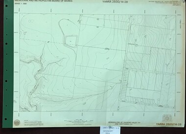
Map, Melbourne and Metropolitan Board of Works. Survey Division, MMBW, Yarra 2500 / 14.28. Yarrambat Park, 1977_09
Melbourne and Metropolitan Board of Works. Yarra 2500 [base map] 14.28. Yarrambat Park. Municipalities of Diamond Valley 257 and Whittlesea 239. Prominent streets include: Bannons Road and Yan Yean Road. Features include the Plenty River.MMBW Map in 1:2500 [scale] series. Cream parchment with green tape reinforcing on edges and punched holes on left edge.mmbw, melbourne and metropolitan board of works, shire of diamond valley, whttlesea, yarrambat - maps -
 Eltham District Historical Society Inc
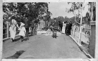
Photograph, Hurstbridge - Cr. Price crossing New Bridge (Opening Day), 1917, 1917
Eltham Shire Councillor Albert Price joined over 500 spectators for the official opening of the new re-inforced concrete bridge across the Diamond Creek at Hurstbridge. Eltham Shire shared the cost of the construction of the bridge with Heidelberg and Whittlesea Shires.This photo forms part of a collection of photographs gathered by the Shire of Eltham for their centenary project book, "Pioneers and Painters: 100 years of the Shire of Eltham" by Alan Marshall (1971). The collection of over 500 images is held in partnership between Eltham District Historical Society and Yarra Plenty Regional Library (Eltham Library) and is now formally known as 'The Shire of Eltham Pioneers Photograph Collection.' It is significant in being the first community sourced collection representing the places and people of the Shire's first one hundred years.Digital imagesepp, shire of eltham pioneers photograph collection, diamond creek, hurstbridge, wattle glen, bridge, councilor price, opening day, diamond creek (river) -
 City of Whittlesea
Print (series) - Photographs - Landscapes, Fred Kruger, Fred Kruger Collection
landscapes of the plenty river regionlandscapes of the plenty river region -
 Greensborough Historical Society
Book, Isabel Ellender, The Plenty Valley Corridor: the archaeological survey of Aboriginal sites / by Isabel Ellender 1991, 1991_
This archaeological survey of the Plenty Valley was conducted by Isabel Ellender in 1991 for the Board of Works (Melbourne Water), in particular the Plenty Gorge Metropolitan Park. The area studied is north of Greensborough to Whittlesea. A number of Aboriginal sites were identified and recommendations made for the future.67 p., illus., maps. Plastic spiral binding.plenty river, aboriginal heritage sites, plenty gorge metropolitan park -
 Melbourne Legacy
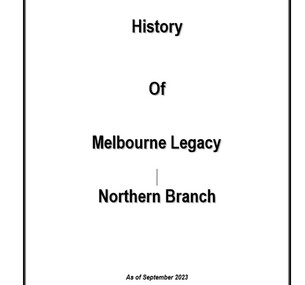
Document, History of Melbourne Legacy Northern Branch
The Northern Branch of Melbourne Legacy was formed in 1984 with a amalgamation of the Heidelberg Branch and Northcote/Preston/Whittlesea Branch. This document outlines the history of both branches. Heidelberg Branch was established 16th October, 1957. The Northcote/Preston/Whittlesea was established 3rd May, 1958. The history was compiled in 1988 by Legatee John N Roscholler and updated by Legatee Ian Harrison and Legatee Derithe Harrison in an addendum. It covers the formation of Widows Clubs. Preston/Reservoir was July 1985. Northcote began in May 1986, Heidelberg was November 1983. The Heidelberg Boys Club was established in 1958 and lasted until December 1979. Also information about the Legacy Support Group and Legacy Leadership Groups.The work of Legacy is worthy of recording and this covers the Northern Branch history.A4 document x 14 pages on the history of Northern Branch of Melbourne Legacy dated September 2023.heidelberg branch, northcote/preston/whittlesea branch, amalgamation, northern branch -
 Eltham District Historical Society Inc
Negative - Photograph, Log bridge over Pheasant Creek, Kinglake, c.1920
Reproduced on p74 of 'Pioneers & Painters' Driver is Mr. F. Thomson, brother of Mrs McMinn. The timber tramway bridge was built by Mr. Munro, owner of the saw mill. The wooden tram rail ran from the timber logging site to saw mill to Whittlesea.Roll of medium format 120 6x6 black and white negative film, 4 framesAgfa APX 100shire of eltham pioneers photograph collection, bridge, f. thomson, kinglake, log bridge, mr. munro, pheasant creek, pioneers and painters, timber tramway -
 Greensborough Historical Society
Map, Melbourne and Metropolitan Board of Works. Survey Division, MMBW, Yarra 2500 / 17.27. Central Hurstbridge, 1978_02
Melbourne and Metropolitan Board of Works. Yarra 2500 [base map] 17-27. Central Hurstbridge. Parish of Greensborough 2724, Municipalities of Diamond Valley 257, Eltham 238 and Whittlesea 239. Prominent streets include: Anzac Avenue and Hurstbridge-Arthurs Creek Road. MMBW Map in 1:2500 [scale] series. Cream parchment with green tape reinforcing on edges and punched holes on left edge.mmbw, melbourne and metropolitan board of works, shire of diamond valley, hurstbridge - maps -
 Greensborough Historical Society
Map, Melbourne and Metropolitan Board of Works. Survey Division, MMBW, Yarra 2500 / 13.26. Yarrambat, Worns Lane, 1978_02
Melbourne and Metropolitan Board of Works. Yarra 2500 [base map] 13.26. Yarrambat, Worns Lane. Municipalities of Diamond Valley 257 and Whittlesea 239. Prominent streets include: Worns Road, North Oatlands Road and Licola Street. Features include Plenty River.MMBW Map in 1:2500 [scale] series. Cream parchment with green tape reinforcing on edges and punched holes on left edge.mmbw, melbourne and metropolitan board of works, shire of diamond valley, whttlesea, yarrambat - maps -
 Greensborough Historical Society
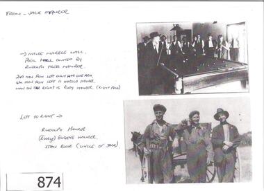
Photograph (copy), Jack Maurer photographs, 1915c
The Maurer family have historical links to the Greensborough area. Marble Hall has been demolished. This is a rare photograph of the interior. [Note: Eltham and Whittlesea Advertiser, on Friday 21 June 1929 Page 2 covers the accidental death of Rudolph Maurer, aged 35] Significant photo of the interior of Marble Hall and the Maurer family.One A4 page, photocopied photographs with handwritten captions.Captions: Photo 1: Inside Marble Hall, pool hall owned by Rudolf Fred Maurer. Photo 2: Rudolf Maurer, Eugene Maurer, Stan Rook (uncle of Jack Maurer)maurer family, jack maurer, marble hall -
![Photograph - Digital image, John and Rosalie McLaughlin [grave], 05/10/1933](/media/collectors/4f729f5697f83e03086015b8/items/543ce58e2162f103802c594f/item-media/543ce6962162f103802c6369/item-fit-380x285.jpg) Greensborough Historical Society
Greensborough Historical SocietyPhotograph - Digital image, John and Rosalie McLaughlin [grave], 05/10/1933
Photograph of the grave of John and Rosalie McLaughlin. The McLaughlin family came to Greensborough circa 1840 from Belfast. In 1865 the family moved to Whittlesea. McLaughlins Lane Plenty is named after the family. The McLaughlin family was related to the Black family of Watsonia by marriage. Rosalie died 30/09/1953.Digital copy of colour photograph.mclaughlin, john mclaughlin, caroline mclaughlin -
 Greensborough Historical Society
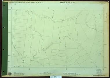
Map, Melbourne and Metropolitan Board of Works. Survey Division, MMBW, Yarra 2500 / 15.27. Yarrambat, De Fredricks Lane, 1977_10
Melbourne and Metropolitan Board of Works. Yarra 2500 [base map] 15.27. Yarrambat, De Fredricks Lane. Parish of Greensborough 2724. Municipality of Diamond Valley 257 and Whittlesea 239. Prominent streets include: De Fredricks Lane, Astons Road and Bannons Lane. Features include Scrubby Creek.MMBW Map in 1:2500 [scale] series. Cream parchment with green tape reinforcing on edges and punched holes on left edge.mmbw, melbourne and metropolitan board of works, shire of diamond valley, yarrambat - maps -
 Greensborough Historical Society
Newspaper clipping, Diamond Valley Leader, Enlisting help: stories honour Anzacs; with Yarra Plenty Regional Library flyer advertising Discover your Anzac story program, 26/11/2014
Research by Maureen Jones about Sgt. Reginald Simms and Nurse Elizabeth Gallagher as part of Yarra Plenty Regional Library publication program about people from Nillumbik, Banyule and Whittlesea who served in World War 1. Includes Yarra Plenty Regional Library flyer about the project.Front page colour image and article and image p. 5. Small colour flyer.world war 1, maureen jones, yarra plenty regional library, reginald simms, elizabeth gallagher -
 Greensborough Historical Society
Map, Melbourne and Metropolitan Board of Works. Survey Division, MMBW, Yarra 2500 / 11.21. Bundoora, east of Plenty Road, 1979_01
Melbourne and Metropolitan Board of Works. Yarra 2500 [base map] 11-21. Bundoora, east of Plenty Road. Parish of Keelbundoora 2856, Municipalities of Diamond Valley 257, Preston 225 and Whittlesea 239. Prominent streets include: Grimshaw Street, Settlement Road and Plenty Road. Includes Yulong Park.MMBW Map in 1:2500 [scale] series. Cream parchment with green tape reinforcing on edges and punched holes on left edge.mmbw, melbourne and metropolitan board of works, shire of diamond valley, bundoora - maps -
 Greensborough Historical Society
Map, Melbourne and Metropolitan Board of Works. Survey Division, MMBW, Yarra 2500 / 13.24. Plenty, Memorial Drive, 1979_03
Melbourne and Metropolitan Board of Works. Yarra 2500 [base map] 13-24. Plenty, Memorial Drive. Parish of Morang 3183. Municipalities of Diamond Valley 257 and Whittlesea 239. Prominent streets include: Oatland Road, River Avenue and Memorial Drive. Includes Plenty River and SEC Transmission easement.MMBW Map in 1:2500 [scale] series. Cream parchment with green tape reinforcing on edges and punched holes on left edge.mmbw, melbourne and metropolitan board of works, shire of diamond valley, plenty - maps -
 Eltham District Historical Society Inc
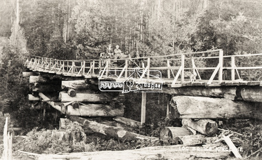
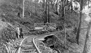
Negative - Photograph, Timber Tramway at Wright's Falls, Kinglake District, c.1920
Man and woman stand beside timber tramway track at Wright's falls Kinglake. The tramway was constructed alongside the road to support the large traffic in firewood between the mountains to Whittlesea. The Wright family owned the land on which the Falls were situated and were sold for a penny an acre according to a Wright family story. This photo forms part of a collection of photographs gathered by the Shire of Eltham for their centenary project book,"Pioneers and Painters: 100 years of the Shire of Eltham" by Alan Marshall (1971). The collection of over 500 images is held in partnership between Eltham District Historical Society and Yarra Plenty Regional Library (Eltham Library) and is now formally known as 'The Shire of Eltham Pioneers Photograph Collection.' It is significant in being the first community sourced collection representing the places and people of the Shire's first one hundred years.Digital image 4 x 5 inch B&W Negshire of eltham pioneers photograph collection, kinglake, timber tramway, wrights falls -
 Greensborough Historical Society
Map, Melbourne and Metropolitan Board of Works. Survey Division, MMBW, Yarra 2500 / 13.23. Plenty, Happy Hollow, 1979_03
Melbourne and Metropolitan Board of Works. Yarra 2500 [base map] 13-23. Plenty / Happy Hollow. Parishes of Morang 3183, Nillumbik 3310 and Keelbundora 2856. Municipalities of Diamond Valley 257 and Whittlesea 239. Prominent streets include: McLaughlans Lane and Happy Hollow Drive. Includes Janefield Colony Reserve.MMBW Map in 1:2500 [scale] series. Cream parchment with green tape reinforcing on edges and punched holes on left edge.mmbw, melbourne and metropolitan board of works, shire of diamond valley, plenty - maps, happy hollow -
 Greensborough Historical Society
Map, Melbourne and Metropolitan Board of Works. Survey Division, MMBW, Yarra 2500 / 13.23. Plenty, Middle Gorge, 1978_04
Melbourne and Metropolitan Board of Works. Yarra 2500 [base map] 13-23. Plenty / Middle Gorge. Parish of Morang 3183. Municipalities of Diamond Valley 257 and Whittlesea 239. Prominent streets include: Gorge Road, Kurrak Road and Browns Lane. Features include the Plenty River and Plenty Gorge Park.MMBW Map in 1:2500 [scale] series. Cream parchment with green tape reinforcing on edges and punched holes on left edge.mmbw, melbourne and metropolitan board of works, shire of diamond valley, plenty - maps, plenty gorge park -
 Eltham District Historical Society Inc
Document - Folder, Maroondah Acqueduct, 2008
Pages copied from the The Heidelberg Historian, newsletter of the Heidelberg Historical Society, February and June 2008 isues relating to guest speaker Lindsay Mann, President of Whittlesea Historical Society and his subject Yan Yean Reservoir: 150 years. - Folder 82 from Harry Gilham Collection. Material merged with folder on Maroondah Reservoir Various pagesyan yean reservoir, lindsay mann, heidelberg historical society, water supply, maroondah reservoir -
 Greensborough Historical Society
Map, Melbourne and Metropolitan Board of Works. Survey Division, MMBW, Yarra 2500 / 11.22. Bundoora, 1979_01
Melbourne and Metropolitan Board of Works. Yarra 2500 [base map] 11-22. Bundoora. Parish of Keelbundoora 2856, Municipalities of Diamond Valley 257 and Whittlesea 239. Prominent streets include: Greenhills Road, Cabernet Crescent and Plenty Road. Includes Parade College (Christian Brothers) and "proposed future freeway" (now Metropolitan Ring Road)MMBW Map in 1:2500 [scale] series. Cream parchment with green tape reinforcing on edges and punched holes on left edge.mmbw, melbourne and metropolitan board of works, shire of diamond valley, bundoora - maps -
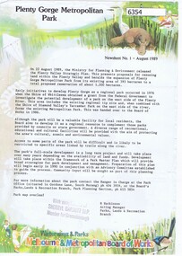 Greensborough Historical Society
Newsletter, Plenty Gorge Metropolitan Park Newsheet No. 1 August 1989, 1989_08
The Shire of Whittlesea obtained a grant from the federal government to investigate the potential development of a park to the west of the Plenty River in 1976. A regional tip site and the Shire of Diamond Valley's Yarrambat Park were handed over to the MMBW to form the existing Metropolitan Park in 1986. A long term project to develop the park further is to commence in 1990.2 p. text, map and col. illus."With compliments of Sherryl Garbutt M.P. Member for Greensborough" (rubber stamp)plenty gorge park -
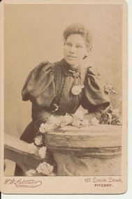 Greensborough Historical Society
Photograph - Digital image, Rosalie Ellen McLaughlin (nee Whatmough), 1899c
Part of a collection of photographs copied from the late Shirley Fraser (nee Black), also descendant of the McLaughlin and Whatmough family. This photograph shows Rosalie Ellen McLaughlin (nee Whatmough). John McLaughlin and Rosalie Ellen Whatmough came to Greensborough in 1840 from Belfast. In 1865 they moved to Whittlesea; McLaughlins Lane in Plenty is named after the family.Digital copy of black and white studio photograph.shirley fraser, rosalie mclaughlin, rosalie whatmough -
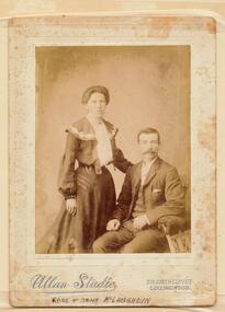 Greensborough Historical Society
Photograph - Digital image, Rose and John McLaughlin, 1910c
Part of a collection of photographs copied from the late Shirley Fraser (nee Black), also descendant of the McLaughlin and Whatmough family. This photograph shows John McLaughlin and Rosalie Ellen McLaughlin (nee Whatmough). John and Rose McLaughlin came to Greensborough in 1840 from Belfast. In 1865 they moved to Whittlesea; McLaughlins Lane in Plenty is named after the family.Digital copy of black and white studio photograph.shirley fraser, john mclaughlin, rosalie mclaughlin, rosalie whatmough -
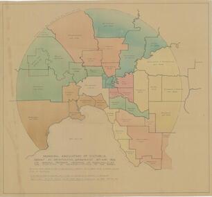 City of Whittlesea
Map - Maps, Municipal Association Of Victoria groupings of councils for representation, 1936
Map was produced as part of Municipal Association of Victoria report on Metropolitan Government, 18 May 1936. Map shows proprosed groupings of municipalities for election of representation to the MAV Board. Map includes net annual value of rateable property within each municipality. The net rateable value for metropolitan area of the Shire of Whittlesea in 1936 was £20,102. Maps, paper. Produced as part of Municipal Association of Victoria report on Metropolitan Government, 18 May 1936. Map shows proprosed groupings of municipalities for election of representation to the MAV Board. council, municipal association of victoria -
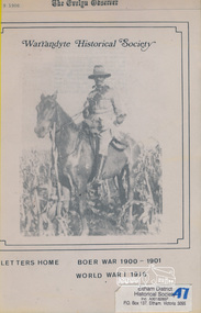 Eltham District Historical Society Inc
Book, Warrandyte Historical Society, Letters Home: Boer War 1900-1901, World War I 1916 (extracts from The Evelyn Observer reproduced by Warrandyte Historical Society)
Copies of newspaper articles copied from "The Evelyn Observer" with dates. Includes some news reports but mostly letters from soldiers. Names include W. J. Beard of Research E. Andrew of Eltham Private S. Harris (Kangaroo Ground, Queenstown and Kinglake) E. Payne (Whittlesea) W Reid of (Hazelglen) W. J. Capewell (Eltham)Various un-numbered pages held in place housed in yellow folder. Photo of soldier on a horse on the cover. No caption but probably Private/Trooper Shelley Harris of Kinglake, Bushmen's Corp. Boer Warevelyn observer, boer war, letters, world war 1 -
 Eltham District Historical Society Inc
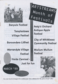
Journal, Peter Doughtery, ArtStreams: News in arts and cultural heritage; Vol. 4, No. 2, Mar-Apr 1999 Month of Festivals Supplement, 1999
Vol. 4, No. 2, Mar-Apr 1999 Month of Festivals Supplement CONTENTS MONTH OF FESTIVALS EVENTS GUIDE Banyule Festival 10 Heidi Festival 13 Petty's Orchard Antique Apple Festival 16 Boroondara LitFest 17 Mullum Mullum Festival 17 Templestowe Festival 19 Warrandyte Festival 21 City of Whittlesea Community Festival 23 "Peter Dougherty has been involved in the local art scene for many years. As publisher and editor of the arts magazine Artstreams, his comments on the various branches of the arts are widely respected. His "The Arts" column in the Diamond Valley Leader presents a brief summary for a much wider cross section of the local community. Peter also operates his own gallery and the Artstreams Cafe at the St Andrews market. Peter has a wealth of knowledge about present day and historical aspects of local art and artists." - Eltham District Historical Society Newsletter No. 161, March 2005Colour front and back cover with feature articles and literary pieces with photographs and advertisements printed in black and white. 36 pages, 30 cm. Vol. 1, no. 1 (Nov. 1996) - Vol. 10, no. 5 (summer ed. 2005/06) art streams, festivals, bnayule festival, eltham wiregrass gallery, willy wonka's ice cream gourmet food, victorian artists supplies, dianne bullen, kate mcgarrigle, anna mcgarrigle, bulleen art & garden centre, museum of modern art at heide, lovegroves of cottles bridge, rosanna community house, recherche, litfest, la piazza restaurant bar & cafe, carlucci's, mullum mullum festival, petty's orchard, festival of kites, mike rudd, bill putt, cynfi boste, bluecasters, templestowe village festival, bi-wize quality paints, jordie albiston, warrandyte village festival, mercer's restaurant, manningham gallery, la trobe university art museum, fleur de feliss florist, city of whittlesea community festival -
 Uniting Church Archives - Synod of Victoria
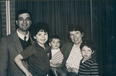
Photograph, Rev. John Canaris, 02/1988
Rev. John Canaris is listed at appointed to Whittlesea in January 1988, but is not listed in the 2000 Assembly Directory. He was 37 when ordained in December 18 1987. Originally from Qld, C&N records that he had been in Horsham for the past six years, and that he had had an "extensive ministry in mass evangelism". He later returned to Brisbane, Qld.B & W photograph of Rev. John Canaris with his wife Karen and three sons."John, Karen and the boys"karen canaris, whittlesea, john canaris -
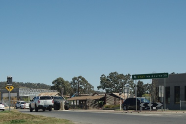
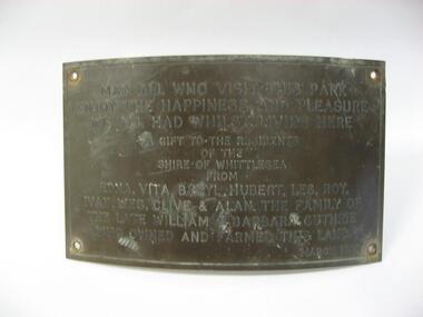 City of Whittlesea
Plaque (item) - Norris Bank Reserve Plaque, Guthrie Family Plaque
May all who visit this park / enjoy the happiness and pleasure / we all had whilst living here / a gift to the residents / of this / Shire of Whittlesea / from / Edna, Vita, Beryl, Hubert, Les, Roy / Ivan, Wes, Clive & Alan the family of the late William & Barbara Guthrie / who owned and farmed this land / March 1981norris bank reserve -
 Greensborough Historical Society
Photograph - Digital Image, Marilyn Smith, Old Mernda Market 2018, 27/09/2018
In 2018 GHS members visited Turner's Bakery in Mernda for lunch and continued on to visit historic sites remaining in the Mernda area. This photograph shows remnants of the Mernda Market, established in 1919 as a livestock market. It was sited on Plenty Road in the carpark of the Bridge Inn Hotel. It evolved into a weekend 'trash and treasure' market although livestock auctions still took place on Mondays. In 2012 the livestock auctions moved to Whittlesea Showgrounds.Mernda is an area of rapid modern growth with a few remaining historic buildings dating from the 19th century.Digital copy of colour photographsmernda, mernda historic sites, mernda market, plenty road mernda, livestock auctions, trash and treasure markets -
 Greensborough Historical Society
Map, Melbourne and Metropolitan Board of Works. Survey Division, MMBW, Yarra 2500 / 12.24. Plenty and Blue Lake, 1977_10
Melbourne and Metropolitan Board of Works. Yarra 2500 [base map]. 12-24, Municipalities of Whittlesea 239 and Diamond Valley 257. Shows street names, easement sizes, lot numbers, lodged plan numbers, names of prominent features, contour values, creek or river names. Watsonia Railway Station and environs. Prominent streets: Memorial Drive. Includes Plenty River and Blue Lake in the Plenty Gorge.MMBW Map in 1:2500 [scale] series. Cream parchment with green tape reinforcing on edges and punched holes on left edge.mmbw, melbourne and metropolitan board of works, shire of diamond valley, plenty - maps, blue lake -
 Greensborough Historical Society
Map, Melbourne and Metropolitan Board of Works. Survey Division, MMBW, Yarra 2500 / 13.22. Greensborough, Apollo Parkways, 1979_06
Melbourne and Metropolitan Board of Works. Yarra 2500 [base map] 13-22. Greensborough, Apollo Parkways. Parishes of Nillumbik 3310 and Keelbundora 2856. Municipalities of Diamond Valley 257 and Whittlesea 239. Prominent streets include: Plenty River Drive, Diamond Creek Road and Civic Drive. Includes Diamond Valley Civi Centre, Churinga, Janefield Colony Reserve and "proposed freeway" now Greensborough Highway (Bypass)MMBW Map in 1:2500 [scale] series. Cream parchment with green tape reinforcing on edges and punched holes on left edge.mmbw, melbourne and metropolitan board of works, shire of diamond valley, greensborough - maps, apollo parkways - maps