Showing 3733 items matching "landscape"
-
 Melbourne Tram Museum
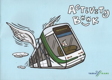
Photograph - Colouring Book, Yarra Trams, "Activity Book", 2006
Colouring or Activity book - 16 pages - A4 landscape with blue colour cover, centre stapled, prepared for the Family Day during the 100 years of Trams celebration at Docklands by Yarra Trams. Features colouring pages, spot the difference, word finder and two, mazes. Has the 100 years of electric tram logo on the rear page and Yarra Trams logos. Two copies held.trams, tramways, 100 years of electric trams, colouring book -
 Whitehorse Historical Society Inc.
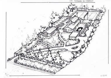
Artwork, other - Ink Line Drawing, Margaret Picken, 103 Terrara Rd. Vermont, circa 1985-2005
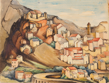
A property illustration by Margaret Picken Commissioned by a real estate agency for the purpose of advertising 103 Terrara Rd. Vermont. This property is listed as having sold in for $400,000 in 1986, and having been sold twice in the interim, sold again in 2004 for $1,080,000. Made by using Rotring ‘Rapidigraph’ drafting pens with Rotring ink on Rapidigraph polyester drafting film, double matte. Trained as a cartographic draftsman within the mining industry, Margaret Picken is an artist who worked producing property illustrations for real estate agencies in eastern suburbs of Victoria from 1983-2005. Retiring from the industry as technological changes favored coloured photography over illustrations, and commissioning companies over sole contractors.This artwork is of Historical Significance as a record of local domestic architecture.A black ink line drawing on drafters film by Margaret Picken, of a birds eye view of a property shown on the diagonal. In the bottom left corner a gated driveway winds toward the upper right, through landscaped gardens. Leading up to a separate multi car garage. There is a sperate annex left of the garage, and the main two story house further back. At the every end of the property is a tennis court.103 Terrara Rd. Vermontwhitehorse historical society, schwerkolt cottage, housing, architecture, margaret picken, house, garden, real estate, vermont, vermont south -
 National Wool Museum
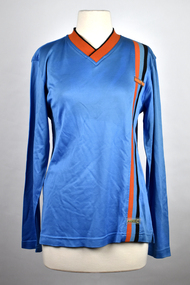
Textile - Australian Open Sportwool Top, CSIRO Division of Textile and Fibre Technology, c. 2000s
Sportwool® was developed to combine the physical performance attributes of synthetics with the comfort and breathability of a natural fibre. It is a lightweight, composite fabric consisting of a layer of machine-washable superfine Merino wool next to the skin and a layer of tough, easy-care polyester on the outside. As a result of this construction: - the wearer feels cooler more quickly and formation of liquid sweat is delayed - liquid sweat is carried away from the skin to the outside of the fabric, leaving - the inside dry and resulting in less ‘clammy’ garment cling - the wearer stays cooler when exercising - ‘post-exercise chill’ is reduced. In addition, Sportwool® is elastic, provides UV protection and does not retain odours. Sportwool® is constructed in weights ranging from ultra-light for jogging, to thicker, heavy-duty fabric for football jerseys. It is easily printed in bright colours and designs, including information about sponsors and players. Sportwool® can also be dyed in solid colours. The development of Sportwool® was funded by The Woolmark Company (now Australian Wool Innovation Limited). Source: https://csiropedia.csiro.au/sportwool/9095.1 - Long sleeve blue sports top with with orange and navy striped detail. 9095.2 - Clothing label tag featuring a black silhouette of a tennis player, with organe and white text and orange and blue graphics on a black background. 9095.3 - Four page fold out clothing label tag, front features printed text, silhouette sports graphics and a background of an orange and blue landscape.9095.1 Australian Open / Sportwool / Sportwool 9095.2 - front: [printed] Australian Open / OFFICIAL / LICENSED / PRODUCT 9095.3 - front: [printed] SPORTWOOL / Vapour Management Technology / www.sportwool.comsportswool, australian open, athletes, clothing, the woolmark company, csiro division of textile and fibre technology, uniforms -
 The Beechworth Burke Museum
Photograph, Unknown
Aerial view of Lake Sambell, Beechworth with town views. Lake Sambell is a beautiful Victorian recreation lake and urban park with a unique history. It was created in the mid-1800s by the Rocky Mountain Mining company during the gold rush era and used as a mining site until the early 1900s, which brought Europeans into the area. It was turned into a reserve for residents in 1920 and is considered an icon of Beechworth as it represents the development of the community, human endeavour, and the spirit of the landscape.This photograph represents Lake Sambell with town views.Black and white reproduced rectangular photograph print on paper.Reverse: Stampbeechworth lake, lake sambell, aerial photo, construction, australian landscape, #beechworth, victoria -
 Eltham District Historical Society Inc
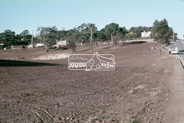
Slide, Construction of Eltham Town Park, 25 Jul 1973
Construction of Eltham Town Park; landscape has been scupltured and lakes formed. View looking up towards intersection of Bridge Street with Main Road. On the high side of Main Road is Garni Burges former home at the corner of Bridge Street then further to the left the former bakery on the corner of York Street. On the opposite corner is the feed store now the site of Le Pine Funerals. The park was later renamed Alistair Knox Park.35 mm colour positive transparency Mount - Agfacolor Service (Blue)Memorial Park 25 July 1973eltham, main road, alistair knox park, eltham town park, shillinglaw cottage, bridge street -
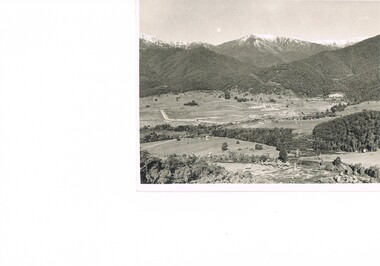 Kiewa Valley Historical Society
Photograph Transmission lines Mount Beauty, 66 KVA Transmission lines from Clover Power Station, Circa 1950
This photograph is a "snap shot" in time circa 1950s detailing the rural environmental change and the progressive effects of the Kiewa Valley Hydro Scheme on the basic rural setting of the valley (note the sparsity of rural infrastructure). This photograph shows the beginning of the accommodation and administration buildings for use by the construction workers and auxiliary administration employees of the Victorian State Electricity Commission. It also provides a view of the landscape before extensive development of Pondage and other non rural buildings.This photograph details a dramatic period in time which saw an enormous change to the exclusively rural area of the Kiewa Valley region in the mid 1900s (see sparse rural buildings/houses). This change presented both physical and mental challenges to the existing quiet rural inhabitants of the valley. The State of Victoria had to make adjustments to the changing demands imposed by population and industrial expansions. The development of cleaner energy supplies to a growing population has its downside ,which ever way the intrusion into the "natural" landscape is made. The construction of the large Pondage at the centre of the photograph is a good example.This black and white photograph of a panoramic view of the Kiewa Valley (Mount Beauty SEC construction workers village) shows the newly completed transmission line towers delivering electrical power(66KVA) from the Clover Power Station. The photo is on 200gms paper and not on special photographic paper.mount beauty 1940 to 1950s, development of sec kiewa hydro scheme, sec victoria -
 Robin Boyd Foundation
Document - Manuscript, Robin Boyd, The Best Houses in the World, 1965
Robin Boyd was on the judging panel for the American Institute of Architects, in conjunction with Sunset magazine, "Best houses" in the West Coast USA in 1965. Interesting commententary is given about the 364 houses entered and the award-winning houses. Some conclusions about what is new in planning are drawn. Comparisons are made with the best Australian houses and landscape architecture of 1965. This manuscript of Boyd's weekly newspaper column in 'The Australian' was published with the same title on 31/07/1965.Original manuscript of an article published in The Australian, 16/10/1965.Two copies. One typewritten (c copy), pencil edits and additions. Second typewritten (p/copy). Both quarto, 7 pages.american institute of architects, california, sunset magazine, house design, 1965, landscape design., robin boyd, manuscript, ohm2022, ohm2022_16 -
 Nillumbik Shire Council
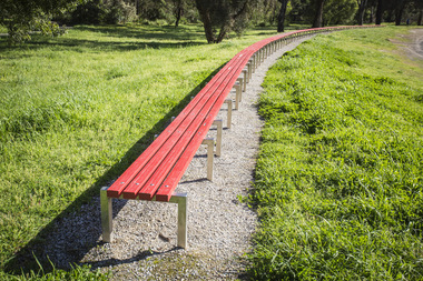
Public Art: Susie KUMAR & Naomi KUMAR, Benchmark (Location: Conventry Oval, Elizabeth Street, Diamond Creek), 1997
1996 Nillumbik Art in Public Places Award (installed late 1997). A biennial program that ceased in 2007. The program commissioned artists to make and install public art in various sites around the Shire. Award judges that year were Tony Trembath and artist Peter D. Cole. Susie Kumar has a Bachelor of Landscape Architecture degree from RMIT and Naomi Kumar has a Bachelor of Fine Art in photography degree from VCA. The Kumar sisters designed the sixty meter gently curving bench in response to the topography of the site, Conventry Oval. The sculpture is designed to describe the boundary between the formal oval and the natural creek bank and a considered relationship to the bike track and the river. It forms a link between the activities and aesthetics of its environment. The work is a comical interpretation of the utilitarian public bench. From a distance the bright red runners (the colour of the local football team's stripe) appear to float about the surrounding green. One end of the work is straight and finished. The other remains 'unfinished' hence allowing for the concept of unlimited extension. The 'legs' (steel hurdles) are arranged with a sense of movement and rhythm in sympathy with the activities happening around the work and with the stands of trees in he background. 'Benchmark' also serves as a functional purpose; providing a choice of places to sit to watch action on the oval. Stainless steel, timber (Victorian Ash) and red enamel paint. Sixty meter long red bench that gently curves in response to Conventry Oval. Bolted on top of evenly spaced stainless steel hurdles, four rows of timber runners are joined to provide unbroken continuous lengths. The bench stands on a framed bed of crushed rock (Lilydale topping).N/Abench, sport, wood, victorian ash, stainless steel, public art, ekphrasis2017 -
 Stawell Historical Society Inc
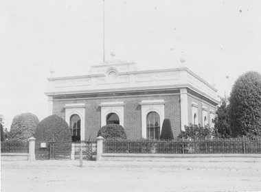
Photograph, Stawell Shire Hall 1866
Stawell Shire Hall built 1866 Hewitt Photo. A professional photograph of the Shire Hall showing the road and footpath in front of the building. The view shows three side windows and two at the front opf the building with four urn shaped decorations on top of the building. A flag post can be seen behind the central building decoration on the roof above the entrance doorway. The landscape around the building is well manicured with tall to medium sized shrubs. Stawell Shire Hall built 1866. Black & white photograph showing a front and side view of the building. This photo shows three side windows compared to an earlier photo, 84.2 where only one side window can be seen.Stawell Photographic Co. Close Railway Station C. HEWITT, Managerstawell -
 University of Melbourne, Burnley Campus Archives
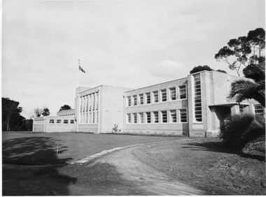
Photograph - Black and white print, Administration Building, 1949
Note by T.H. Kneen 20.02.1991, Early stages of landscaping for the new building. Note young Magnolia grandiflora planted to soften stark wall. The building comprised right to left Principal's office, office for school teaching staff, offices for Fruit Preserving Branch, Agrostology Branch and future Plant Breeding Branch (branches of the Department of Agriculture), four class rooms, Assembly Hall, Library and student change rooms. The old Pavilion was demolished earlier.3 copies black and white photographs. Very similar views of the newly constructed Administration Building. Planting around the building. Flag flying.principal's office, fruit preserving branch, agrostology branch, plant breeding branch, assembly hall, library, pavilion, planting, landscaping, magnolia grandiflora, staff room, class rooms, student change rooms -
![Royal Australian Nursing Federation campaign badge, [1986?]](/media/collectors/5bb42dc221eaf31100db1d3b/items/5c4668dc21ea670150f8e407/item-media/5c46691f21ea670150f94202/item-fit-380x285.jpg) Australian Nursing & Midwifery Federation
Australian Nursing & Midwifery FederationRoyal Australian Nursing Federation campaign badge, [1986?]
Distributed to nurses during campaigning for improved wages and working conditions in the 1980s, possibly during the historic 1986 Victorian 50-day nurses strike. The Royal Australian Nursing Federation (RANF) became the Australian Nursing Federation in 1989, suggesting that this button is from the late 1980s. Similar to the badges worn in this photo [https://stories.anmfvic.asn.au/86strike/media/2560-1440-landscape-sec2-contentb-hr_logwf7a.jpg] from 1986 (see individual on the far right).Circular white and blue plastic button. Silver metal, plastic-coated, with safety pin fastener adhered to back. Button printed with 'KEEP NURSES NURSING - Improve Nurses' Conditions' and 'R.A.N.F. [Royal Australian Nursing Federation] Vic. [Victorian] Branch'.nursing, industrial action, strike action, unionism, badges, nurses, buttons, pins, campaigning, trade unions, labour history -
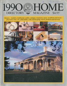 Eltham District Historical Society Inc
Magazine - Magazine Article, Rosscorp Pty Ltd, 1990 Home Directory Magazine, 1990
Articles featuring local Eltham mudbrick houses designed by Robert Marshall, Alistair Knox, etc and landscape bush gardens by Gordon Ford • “At Home with the Browns”, pp114-116 ‘Cherrytrees’, home of Margaret and Neil Brown, originally built in 1917 for eminent Collins Street surgeon, Dr. Kent-Hughes. • “The Mud Brick homes of Eltham”, pp148-149 References to Alistair Knox and Robert Marshall • “Mudbrick Collecting”, pp150-155 Features a Robert Marshall designed home built by Barry Wild and Geoff Williams • “Mudbrick sophistication”, pp156-158 Features a Robert Marshall designed home with Gordon Ford landscape garden • “It grew like topsy”, pp160-162 originally designed by Alistair Knox then extended upon • “A love of the environment”, pp163-164 Features artist and local Councillor Jenni Mitchell’s mudbrick cottage designed by Bohdan (Danny) Kuzyk with influences of Alistair Knox • “Build your own muddy”. Pp165-167 • “Pioneer of bush gardens; Gordon Ford and his no mowing no weeding approach”, pp174-177 robert marshall, alistair knox, gordon ford, mudbrick, margaret brown, neil brown, cherrytrees, dr kent-hughes, eltham, barry wild, geoff williams, jenni mitchell, bohdan (danny) kuzyk, bush gardens -
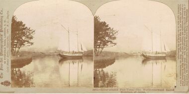 Bendigo Historical Society Inc.
Photograph - BLACK AND WHITE PHOTOGRAPH: JAPANESE YACHT
photograph - black and white -Japanese Yacht mounted on cardboard /The fine-art photographers publishing company , 46 Rydevale Rd , london S.W , Gold Medal series , Copyright 1901 , B.L. Singley -/ Stereo photograph - two photos side by side forming into one with use of relevant mechanism / rear small note describing the viewThe fine-art photographers publishing companyphotograph, landscape, -japanese yacht /the fine-art photographers publishing company , 46 rydevale rd , london s.w , gold medal series , copyright 1901 , b.l. singley -
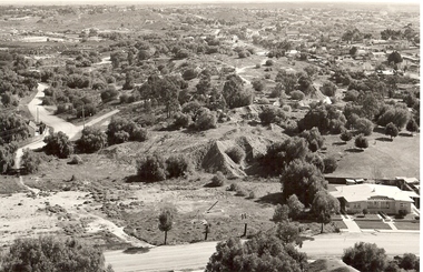 Bendigo Historical Society Inc.
Photograph - VIEW OF MINING AREA - VICTORIA HILL
Black and white photograph. View overlooking north from Victoria Hill, mullock heaps, houses - some mid to late 20th century and some miner's cottages, formed road, children's playground centre foreground. Inscriptions: on back - purple rubber stamp 'Robert Wallace Studios, 6 Ruth Street, Golden Square, Phone Bgo 37565.Robert Wallaceplace, mining site, victoria hill, bendigo, mines and mining, landscape, mining landscape, mullock heaps -
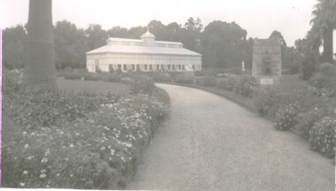 Bendigo Historical Society Inc.
Photograph - CONSERVATORY GARDENS
Black and White Photo of the Bendigo Gardens with the Conservatory in view in the centre of the imagephotograph, landscape, bendigo conservatory, bendigo, bendigo gardens, bendigo conservatory, gardens, conservatory -
 Bendigo Art Gallery
Work on paper, Madge FREEMAN, Italian Hilltop II, 1953
signed l.l., pen and ink, MADGE FREEMANcountryside, european, italy, landscape, village, town, watercolour, female artist -
 Bendigo Art Gallery
Work on paper, John WOLSELEY, The Language of Lizards, 2007-2008
l.r; Murray Sunset Wilderness, 2008, John Wolseleyaustralian artist, landscape, lizards, murray river, tree, flower, flora, abstract -
 Ballarat Heritage Services
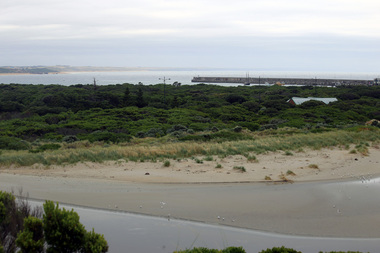
Photograph - Digital photographs, L.J. Gervasoni, Breakwater and Lady Bay, 2016
Digital imageslandscape, seascape, geology, warrnambool, coast, coastal, breakwater, lady bay -
 Ballarat Heritage Services
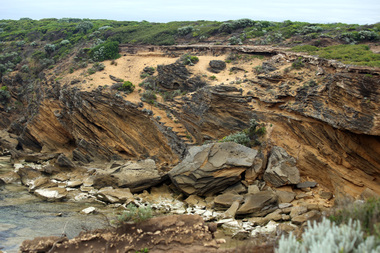
Digital photographs, L.J. Gervasoni, eroded steps, 2016
Digital imageslandscape, seascape, geology, warrnambool, coast, coastal, thunder point coastal walk, steps -
 Ballarat Heritage Services
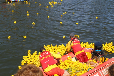
Digital photographs, L.J. Gervasoni, getting the ducks back in the boat, c2013
Colour photograph of the Duck Race on teh Moyne River held on New Year's Day at Port Fairy. landscape, port fairy, beach, waterscape, moyne river, moyneyana, new years day, duck race -
 Ballarat Heritage Services
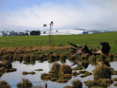
Digital Photograph, L.J. Gervasoni, Melting Snow Newlyn, 2006
Digital Photograph od snow on a distant hill at Newlyn.snow, weather, victoria, newlyn, hepburn shire, agriculture, landscape, rural -
 Ballarat Heritage Services
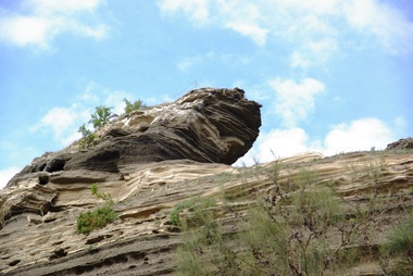
Digital photographs, L.J. Gervasoni, Tower Hill - international geological significance, c2015
tower hill, volcano, natural heritage, koroit, landscape, ash, geological, international significance -
 Ballarat Heritage Services
Photograph - Digital photographs, L.J. Gervasoni, Tower Hill - international geological significance - maar, c2015
Digital Photographs of tower hill near Koroit Victoria tower hill, volcano, natural heritage, koroit, landscape, ash, geological, international significance -
 Ballarat Heritage Services
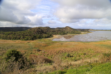
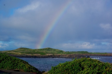
Digital photographs, L.J. Gervasoni, Griffith Island, Port Fairy, c2013
Colour photograph of Griffiths Island. landscape, port fairy, beach, waterscape, moyne river, griffith island, rainbow, weather -
 Ballarat Heritage Services
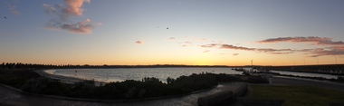
Photograph - Digital photographs, Clare Gervasoni, The Warrnambool Coast from Lady Bay, 29/06/2020
Panoramo at Warrnamboollandscape, seascape, geology, warrnambool, coast, coastal, breakwater, lady bay -
 Ballarat Heritage Services
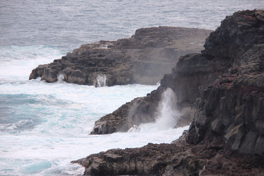
Digital photograph, Lisa Gervasoni, Cape Bridgewater, c2015
cape bridgewater, geology, ocean, coastal, landscape, seascape, blowhole, volcanic rock -
 Ballarat Heritage Services
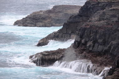
Digital photograph, Lisa Gervasoni, Cape Bridgewater, c2015
Colour photograph of the coastline at Cape Bridgewater, Victoria. cape bridgewater, geology, ocean, coastal, landscape, seascape, blowhole, volcanic rock -
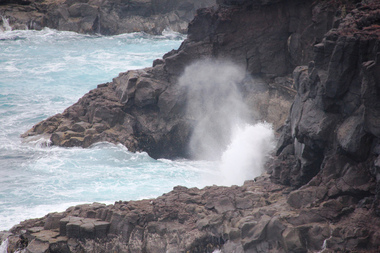 Ballarat Heritage Services
Digital photograph, Lisa Gervasoni, Cape Bridgewater, c2015
cape bridgewater, geology, ocean, coastal, landscape, seascape, blowhole, volcanic rock -
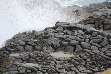
 Ballarat Heritage Services
Digital photograph, Lisa Gervasoni, Cape Bridgewater, c2015
cape bridgewater, geology, ocean, coastal, landscape, seascape, blowhole, volcanic rock -
 Ballarat Heritage Services
Digital photograph, Lisa Gervasoni, Cape Bridgewater, c2015
cape bridgewater, geology, ocean, coastal, landscape, seascape, blowhole, volcanic rock