Showing 110201 items matching "roads"
-
 Linton and District Historical Society Inc
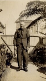
Photograph, Tom Jones, c1940
Thomas Jones, the son of Matthew Jones and Ann Jones, nee Parker, was born at Banongill Station near Skipton in 1859. He died at Linton in 1942. The photograph was probably taken in the garden at Murrell's newsagency in Sussex Street, Linton - Tom and Bill Murrell were good friends.Black and white photograph of a man wearing a suit, standing on a garden path.On back: "Thomas Jones, Geelong Road, Linton".thomas jones, old lintonian collection, tom jones -
 Lakes Entrance Historical Society
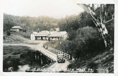
Postcard - Blue Duck Hotel, 1940
Hotel buildings moved from Omeo to present site, 1928 by William O'ConnellBlack and white postcard showing Blue Duck Hotel, Glen Wills Rd, East Gippsland, Victoria. Bridge over Mitta Mitta River, house at back, sedan car leaving bridge, dense forest surrounding.Blue Duck Hotel Glen Wills Roadbridges, hotels -
 Uniting Church Archives - Synod of Victoria
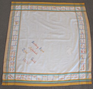
Textile - Tablecloth
Square tablecloth with text embroidered in squares around edges. The cloth has a yellow, blue, green and red border."Darling Road Methodist Ladies Guild 1939"methodist ladies guild, darling road east malvern methodist church -
 Kew Historical Society Inc
Photograph - Construction of the Eastern Freeway (F19), Ron Setford, March 1972
Ron Setford and his wife Grace Setford lived in Tanner Avenue, East Kew, from c.1946 to c.1995. A keen photographer, he recorded the changing face of Kew over a 20 year period. Apart from 30 photographs of built structures and places in Kew dating from 1960 and 1961, 145 of his 35mm colour slides chronicle the development of the F19 (later renamed Eastern) Freeway through the Yarra Valley in Kew over a five year period from c.1972 to c.1977. This important collection was donated to the Society by his granddaughter in 2025.This collection of 175 35mm slides is of local and statewide significance, owing to its subject matter, particularly the major development of road transport infrastructure during the 1970s with the construction of the Eastern Freeway. The photographer also took care to annotate and date most of his slides which enable the researcher to pinpoint temporal and spatial locations.Kilby Rd, Willsmere Park on left"Eastern Freeway / Kilby Road / Nov 72"ron setford, eastern freeway, f19 freeway, willsmere park, kilby road -
 Lakes Entrance Historical Society
Domestic object - Souvenir dish
China dish with photograph of view from Jemmys PointNew Road Jemmys Point Lakes Entrancetourism, mementos -
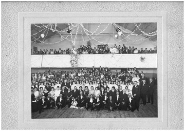 Chelsea & District Historical Society Inc
Photograph - Ball for opening of Mason's Theatre, Station Street, Chelsea, 1923
The theatre was built by Mr William James Mason in 1922/23.Black and white photo on a backing sheet. A large group of people, formally dressed, some standing on the floor of the theatre and others in the balcony area of the theatre.F. Cumming Studio, Frankston Road, Chelsea.theatre, chelsa picture theatre, mason's theatre, celebrations, chelsea, plaza theatre -
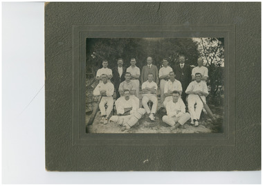 Chelsea & District Historical Society Inc
Photograph - Cricket team and officials, c 1910
Black and white photo on mounting board of a cricket team and the officials, with the names of the peopleF. Cummings Studio Frankston Road, Chelseacricket, sport, chelsea -
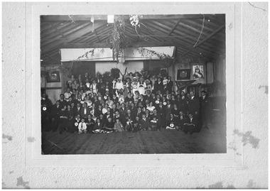 Chelsea & District Historical Society Inc
Photograph - Fancy Dress Ball, Edithvale Boat Club, c 1923
Fancy Dress Ball held at Edithvale Boat Club.A photograph of men, women and children attending a fancy dress bal at Edithvale Boat Club. On the rear of the photo ten people have been identified: 1 - Mr Case; 2 - Mr and Mrs Plain (owner of the Unity Theatre); 3 - Mr Rowe; 4 - Mrs Bert Smith; 5 - Alf Case; 6 - Sid Munro; 7 - Bert Richardson; 8 - Marg Upton; 9 - Nellie Cameron; 10 - Arthur Upton. F. Cumming Studio. Frankston Road, Chelseacarrum, chelsea, carrum mechanics hall, fancy dress ball, social function, clothing -
 Eltham District Historical Society Inc
Photograph, Thompson Crescent area, Research
Three colour photographs of roads in the Thompson Crescent area, Research 1. Norman Road/Keith Court 2. Reynolds Road/Thompson Crescent North and Nicholson Street 3. Thompson Crescent, Researchthompson crescent, norman road, keith court, reynolds road, nicholson street, research -
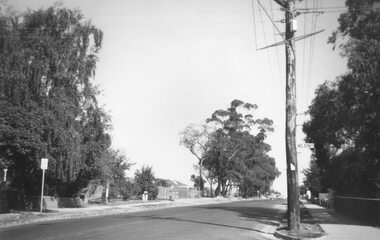 Ringwood and District Historical Society
Photograph, Ringwood Street at Nelson Street Ringwood, looking south, early 1960s prior to Eastland development
Black and white photograph showing made road. Telegraph pole on right of picture. Tall trees to left of photograph. Houses either side of road. Road sign on telegraph pole reads, "Nelson St."Typed below photograph, "Ringwood St. looking south. Ringwood Reserve to left of row of trees in centre." -
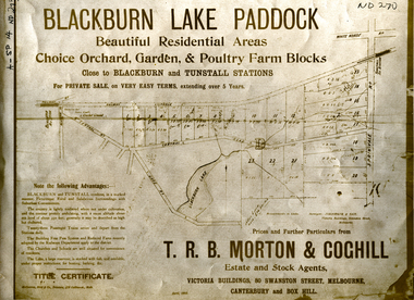 Whitehorse Historical Society Inc.
Document, Blackburn Lake Paddock
Brochure of Blackburn Lake Paddock consisting of 23 residential areas,Brochure of Blackburn Lake Paddock consisting of 23 residential areas, orchard, garden and poultry farm. Bounded by railway to Lilydale, Central Road, Lake Road, Springvale Road and close to Blackburn and Tunstall Stations.Brochure of Blackburn Lake Paddock consisting of 23 residential areas,t. r. b. morton & coghill, johnstone & tait, mccarron bird & co., blackburn lake paddock, central road, blackburn, lake road, springvale road, nunawading -
 Whitehorse Historical Society Inc.
Photograph, Narmara Primary School, 13/01/1994 12:00:00 AM
Coloured photo of Narmara Primary School looking North along East boundary. School on North side of Highbury Road between Middleborough Road and Blackburn Road. Since demolished and site developed for housing.narmara primary school, warner, philip -
 Whitehorse Historical Society Inc.
Photograph, Narmara Primary School, 13/01/1994 12:00:00 AM
Coloured photo of Narmara Primary School site looking West along Highbury Road. School on North side of Highbury Road between Middleborough and Blackburn Roads. Since demolished and site developed for housing.narmara primary school, warner, philip -
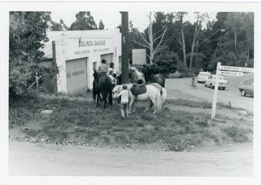 Mt Dandenong & District Historical Society Inc.
Photograph, Pony Club Outside Olinda Garage 1960s, c1960
Olinda garage on corner of Range Road and Mt Dandenong Tourist Road. Pony Club with 4 horses on grass. ralph Jones was garage owner at this time. Dragster bike on road indicates early 1960s.pony club, olinda garage, garage, olinda, range road, mt dandenong tourist road, ralph jones -
 Whitehorse Historical Society Inc.
Photograph - ColouredPhotograph, Narmara Primary School, 13/01/1994 12:00:00 AM
Coloured photo of Narmara Primary School, looking North from south boundary. School on North side of Highbury Road between Middleborough Road and Blackburn Road. Since demolished and site developed for housing.narmara primary school, warner, philip -
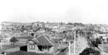 Surrey Hills Historical Society Collection
Photograph, Surrey Hills viewed from 'Quamby' at 293 Mont Albert Road, c 1915, 1915
Quamby was built in 1898. From 1900/1903-1924 it was the home of Andrew Sherar and family. From 1924-1960s it operated as Mosgiel Hospital under the direction of Matron Elizabeth Anderson. Until Box Hill Hospital opened most Surrey Hills children were born at Mosgiel or at Nethercourt Hospital in Wilson Street or later in Union Road when Matron Tank moved her hospital here. Mosgiel Hospital was demolished c 1975 after it was sold by Box Hill Hospital. It was replaced by units. Andrew Sherar was conductor of the Wyclif Church choir for many years and was a member of the Melbourne Liedertafel. Isie Sherar was organist at Wyclif Church and also taught piano in Union Road. Connie Sherar was in the Wyclif choir and married Ernest Swan, an elocutionist and orator. Dorothy Sherar was a pianist and accompanist. Elsie Sherar was also in the Wyclif choir and was a soloist; she later moved to Templestowe. Ken Sherar was a boy soprano at St Paul's Cathedral; he later moved to Queensland.Black and white photo looking south down Vincent Street from 'Quamby', located at 293 Mont Albert Road, Surrey Hills. In the centre foreground is a timber house with 2 chimneys and a tiled hip roof. It has a return veranda and is fenced on 2 sides by paling fences and picket fences on the other two. In the background are many more houses. A road lined with power poles runs from the right foreground to the middle distance.quamby, vincent street, edwardian style, topography, andrew sherar, isie sherar, connie sherar, dorothy sherar, ken sherar, elsie wappet -
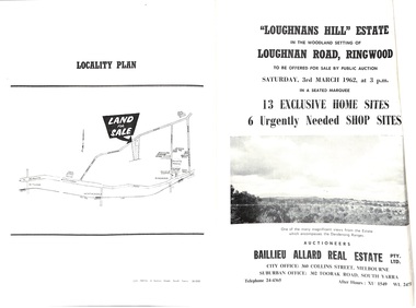 Ringwood and District Historical Society
Document - Folder, Subdivision Auction - Loughnans Hill Estate 1962, Ringwood, Victoria
Double-sided bifold page advertising auction on Saturday 3rd March, 1962 - 13 residential allotments in Hearthside Court and 6 shop sites in Loughnan Road, with map of subdivision, terms of sale, and summary of features and services. Adjoining service station shown on accompanying Plan of Subdivision - Part of Crown Allotment 28 Parish of Warrandyte, also showing location of property known as "Hearth", hence Hearthside Court.Auctioneers - Baillieu Allard Real Estate Pty Ltd., 360 Collins Street, Melbourne, and 302 Toorak Road, South Yarra. Telephone 24-4365, After hours XU1549, WL2471. -
 Whitehorse Historical Society Inc.
Photograph, Installation Underground Wiring, 1/06/1999 12:00:00 AM
Coloured photo of Installation of Underground Wiring Whitehorse Road, Mitcham, opposite East Doncaster Road. Photo taken from outside 602 Whitehorse Road, Mitcham. The works were being carried out in the median strip between the service road and the west bound section of the highway.|Flooring Giant is no longer a tenant, but were located on the north west corner of Whitehorse and Doncaster Roads, Mitcham.whitehorse road, underground wiring -
 Falls Creek Historical Society
Photograph - Upper Kiewa Valley Road, Falls Creek
MEYER COLLECTION - FALLS CREEK PHOTOS In 1947 a determined group of like-minded State Electricity Commission (SEC) staff including Ray Meyer, the chief surveyor of the Kiewa Hydro-Electric Scheme, had a common interest that revolved around the skiing potential of the snow-covered high plains which included what is now the resort of Falls Creek. The six SEC employees, Toni St Elmo, Ray Meyer, Jack Minogue, Lloyd Dunn, Adrian Ruffenacht and Dave Gibson (together with their families) banded together to secretly build a 'hut' that was the first ski lodge at Falls Creek. Using a road built in 1930s to gain access to Falls Creek, their hut project was carried out in secret as efforts by other skiers were blocked by H.H.C. Williams – the engineer in charge of the Hydro Scheme. In 1946 Ray Meyer made a trip to the Lands Office in Melbourne. He came away with a 99-year lease on three acres that was ideally suited for a hut designed by Lloyd Dunn. Adrian Ruffenacht (Design Engineer for the KHS) had suggested where the group should build because of easy access to a spring for water. Much of the building material required was scavenged from derelict huts on the high plains. Due to the need for secrecy, the determined group worked on the hut in the evenings and weekends to avoid detection. During the building period the group had met at Echidna Rock (now known as Eagle Rock) where Skippy St Elmo announced, "This is my favourite ‘Skyline’.” And so the first lodge in the area at Falls Creek Ski Resort came into existence. With the development of the International Poma in the 1970s, the Skyline Lodge, which was sited between the ski-lift’s pole one and pole two, was demolished. However, the legacy of Ray Meyer, Toni St Elmo, Jack Minogue, Lloyd Dunn, Adrian Ruffenacht and Dave Gibson and Skyline lives on in the vibrant atmosphere of Falls Creek Resort. The MEYER COLLECTION documents developments on the Kiewa Hydro Scheme and their life at Falls Creek from the mid 1930s to 1960s.This image is significant because it depicts aspects of the life of a pioneering family of Falls Creek and the founders of "Skyline", the first lodge at Falls Creek.A photo of the Upper Kiewa Valley Road, Falls Creek. Arrows have been marked on the photo to indicate key locations. L to R:- Tony's Old place; Windy Corner: Tony's Preb./ Road.falls creek, toni st elmo, toni beveridge hydrographer -
 Kew Historical Society Inc
Plan - Subdivision Plan, Balwyn Theatre and Shop Sites, circa 1927-28, c.1927-28
The Kew Historical Society's map collection includes a substantial number of real estate subdivision plans, mainly of Kew but also of surrounding suburbs in Melbourne. Most of the subdivision plans date from the 1920s and 1930s when the districts old homes and local farmland were being split up to accommodate residential growth in the postwar period. These early plans were assembled by a local firm, Jas R Mather & McMillan, which had an office in Cotham Road. Many of the plans, and sometimes photos, were annotated by the agents. The ‘new’ Balwyn Picture Theatre was built and owned by Balwyn Theatres Pty Ltd in ca. 1928. By 1930, this first Balwyn Theatre was destroyed by fire after a break-in. Following the fire, a new cinema was constructed. This plan for a Cinema and eleven shops presumably dates from 1927/28 when the Company announced that this location in Whitehorse Road ‘was the most central and best suited [area] for their Theatre and shops’.Subdivision plans are historically important documents used as evidence for the growth of suburbs in Australia. They frequently provide information about when the land was sold as well as evidence relating to surveyors and real estate and financial agents. The numerous subdivision plans in the Kew Historical Society's collection represent working documents, ranging from the initial sketches made in planning a subdivision to printed plans on which auctioneers or agents listed the prices for which individual lots were sold. In a number of cases, the reverse of a subdivision plan in the collection includes a photograph of a house that was also for sale by the agent. These photographs provide significant heritage information relating house design and decoration, fencing and household gardens.The photograph may also be aesthetically significant depending on the importance of the photographic atelier.Subdivision plan showing the Balwyn Theatre and its adjoining shop sites in Whitehorse Road Balwyn. The 11 shop sites were noted for their depth (133 ft - 145 ft. [Map.0041]balwyn theatre -- balwyn (vic.), subdivisions -- balwyn (vic), subdivision plans -
 Surrey Hills Historical Society Collection
Photograph, View from Goodwood Street, Surrey Hills in 1930, 1930
The Breeden family came to Surrey Hills in 1905, first to Guildford Road, then Middlesex Road where Horrie Breeden lived as a boy. He sometimes used to help with milking at the adjoining Kenneally's dairy in Highfield Road. Sometimes he and his brother drove the cows from there to Schneider's property near Florence Road on the way to Surrey Hills Primary School. The cows would graze here until the boys took them back after school. At other times he would deliver milk from the Croydon Road dairy (Isherwood's or Bovill's) to St Joseph's Boys Home before school. Horrie became an apprentice in woodwork / carpentry at Vine's timber yard before serving in World War 1. Horrie's father died in 1919 and in the same year he bought 3 cows and established his own dairy on his mother's property on the corner of Goodwood Street and Boisdale Road. In the 1920s Horrie built the first house in Goodwood Street. He went on to build others in the street including his own at No 7 Goodwood Street. He did all the joinery and internal fittings for this. [REF: Oral testimony: Horrie Breeden to Jocelyn Hall in 1979.] In the 1990s the owner of 7 Goodwood Street discovered a branding iron under the house; this is presumed to relate to Horrie Breeden's dairy. It was donated to SHNC's collection. Horrace Bruce Breeden (7 July 1898-24 January 1988) was son of Charles Henry Breeden and Lavinia Maria Darby, both born Warwickshire; buried in Box Hill Cemetery. He was one of a large family. He married Olive Mary Romey.Black and white photo taken from the east end of Goodwood Street, Surrey Hills in 1930, looking towards Elgar and Riversdale Roads. It shows an area which is rural in appearance. It is not built upon. The foreground is grassy and there is a post-and-wire fence to the right. There is a bank of eucalyptus trees behind which is hilly grassland.goodwood street, dairies, horace breeden, horrie breeden -
Whitehorse Historical Society Inc.
Article, Henry William Crouch, 11/12/1985 12:00:00 AM
Article in the Mirror by Joan Seppings Webster about Henry William Crouch.Article in the Mirror by Joan Seppings Webster about Henry William Crouch. Born in the U.K. and migrated to Australia aged 32. Married Sarah Lewis 6 years before leaving London. They lost their first 3 children and had 2 living sons. Henry, the eldest became a shire councillor. Henry William bought land in Church Road and started an orchard, prospered and later bought land in Williamson's Road on which 6 generations lived over 122 years. Sarah died and he married Harriet Tainton and they had 4 more children. Henry died by accident in 1913 aged 93.Article in the Mirror by Joan Seppings Webster about Henry William Crouch. crouch, henry william, lewis, sarah, crouch, henry, crouch, percival, church road, doncaster, williamson's road, doncaster, doncaster, doncaster church of christ, tainton, harriet lowan -
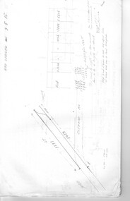
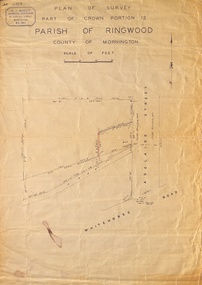 Ringwood and District Historical Society
Map, Plan of Survey, Part of CP12, Adelaide Street, Ringwood, Circa 1920s
Undated map of part of commercial area in Parish of Ringwood, County of Mornington showing Adelaide Street, Whitehorse Road, and un-named laneway behind Whitehorse Road shops marked as Road, and New Road Alignment. Made by H.J. Macey, Licensed Surveyor 36 Narissa Street Burwood BX1917. -
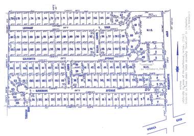 Ringwood and District Historical Society
Map, Subdivision Plan - Rosebank Avenue area, North Ringwood, Vic. - circa 1960s
Single page plan printed on green background showing allotments included in un-named subdivision layout surrounding "Rosebank" property, Warrandyte Road, Ringwood North. Subdivision includes Through Road, Rosebank Avenue, Macey Grove, Goldsmith Avenue, Dillon Grove, Lockhart Road, and Warrandyte Road.Typewritten notation against "Rosebank" property - "Mrs Godbehear, Snr.". "Goldsmith is maiden name of Mrs. Godbehear, Senior. (1960). Lockhart is town where their property "Rosebank" is situated. (In Riverina)". Additional Rosebank Avenue allotments blueprint clipping on light cardboard backing incldes handwritten title reference LP57659. -
 Melbourne Tram Museum
Document - Research Notes, H. S. McComb, development and timing of the "PMTT" part 3, 1950's
Set of papers, handwritten concerning the development and timing of the "PMTT", Prahran and Malvern - about 30 sheets. Prepared by H. S. McComb - gives layout of the PMTT system, of track layout, opening dates, sketches of various junctions, bridges, track miles, junctions: Kew Junction, Glen Huntly Road, Glenhuntly Road, Victoria St cable tram terminus, Barkers Road, Commercial Road, Malvern Road, Hawthorn Road, Balaclava Junction, Caulfield station loop, Glenferrie Road. Items 2041 to 2052 within box 72.3 in a brown folder marked "PMTT" in red pencil.trams, tramways, pmtt, malvern, routes, track, kew junction, victoria st, barkers rd, glenhuntly rd, malvern rd, caulfield, hawthorn rd, balaclava rd, balaclava junction, glenferrie rd -
 Ballan Shire Historical Society
Map - Map. Ballark, Department of Lands and Survey, Ballark. County of Grant, 31/08/1915
A map of the Ballark area within the County of Grant showing roads, waterways, property boundaries and property owners in 1915.Significant to people researching land usage and ownership. Also those researching families in the area at that time.A map of Ballark in the County of Grant. Black printing on buff coloured paper. Extra notations by hand and various coloured highlighting of certain features. Details roads, rivers, property boundaries and names of property owners and districts. The map is easily readable although there is some physical damage to the borders and some sellotape residue. Shows a scale in Chains and the number L.6030Various numbers and directional arrows added to map.bungal, borhoneyghurk, bungeeltap, ballark, beremboke, moreep, meredith, morrisons, moorarbool river -
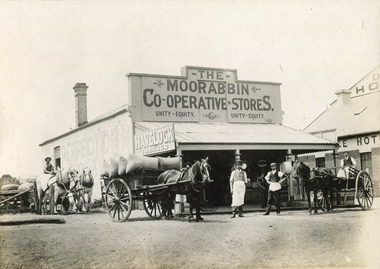 City of Moorabbin Historical Society (Operating the Box Cottage Museum)
Photograph - Photograph, 1906 The Moorabbin Co-Operative Stores, 1906 The Moorabbin Co-Operative Stores, 1906
1906: The Moorabbin Co-Operative Stores. Located on the Nepean Road, Cheltenham, (before 1st WW). . There are four men outside the Store and a 3 horse carriage. Two of the men are sitting on their carriages, one to the left and the other on the right of the photograph. The third horse and carriage is right beside the left of the store, carrying eight large sacks. Towards the side of the Moorabbin Stores there is a building located to right which is called The Exchange Hotel.1906: The Moorabbin Co-Operative Stores. Located on the Nepean Road, Cheltenham, (before 1st WW). The Leader Newspaper office occupied the site. The Exchange Hotel is to the right.Photograph is black and white. 1906: The Moorabbin Co-Operative Stores. Located on the Nepean Road, Cheltenham, (before 1st WW). The Leader Newspaper office occupied the site. The Exchange Hotel is to the right.Stamped on back :City of Moorabbin Historical Society Written on Front of mount : 1906moorabbin, stores, horses, men, ww1, world war 1, tobacco, nepean road, co-operative, cheltenham -
Glenelg Shire Council Cultural Collection
Photograph - Photograph - road construction, Portland, n.d
Port of Portland Authority ArchivesBack: 58% - centre in reen pencil. Pencil border 1cm wide. Reduce to 28cms wide top border in pencil.port of portland archives, road construction, madeira packet road, k s anderson wharf -
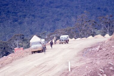 Stawell Historical Society Inc
Slide, Ian McCann, Looking at the valley, 1960's
Colour Slide, showin a dirt road with two vechiles, on truck and one Land Rover, also five males on the roadgrampians -
Whitehorse Historical Society Inc.
Article, Up and over to school
The Country Roads Board has released details of the overpass to be built over Whitehorse Road outside Blackburn Primary School.The Country Roads Board has released details of the overpass to be built over Whitehorse Road outside Blackburn Primary School.The Country Roads Board has released details of the overpass to be built over Whitehorse Road outside Blackburn Primary School.victoria. country roads board, whitehorse road, blackburn, blackburn primary school, no. 2923