Showing 2266 items
matching map collections
-
 Bendigo Military Museum
Photograph - 4th Field Survey Squadron – Operation ARIGHT 91, Queensland, 1991
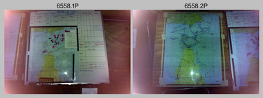
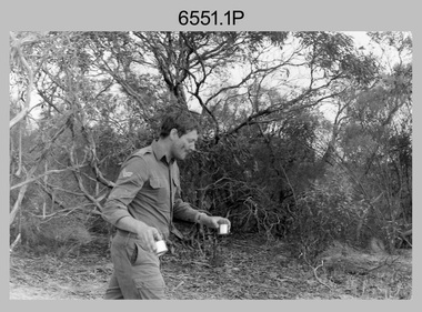
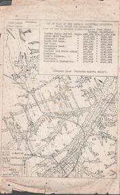
This is a set of 16 photographs taken during 4th Field Survey Squadron’s deployment on Operation ARIGHT 91 in Queensland from the 8th of July to the 5th of September 1991. The area of operations was the top end of the Cape York Peninsula, islands of the Torres Strait and the southern coast of PNG. Field parties utilised Texas Instruments TI4100 Global Positioning System receivers. Concurrent with GPS operations Doppler point positioning observations were carried out by field parties using Magnavox MX 1502 receivers on six of the control points. Two Bell UH-1H Iroquois helicopters from RAAF’s 171 COMD and Liaison Squadron were primarily used to deploy GPS field parties. Identification photography of control points was taken by air camera operators in AAAvn Pilatus Porter aircraft from 173 Gen Spt Sqn fitted with an RC10 aerial camera.This is a set of 16 photographs taken in 1991 during 4th Field Survey Squadron’s deployment on Operation ARIGHT in Queensland. The colour photographs are on 35mm negative film and are part of the Army Survey Regiment’s Collection. The photographs were scanned at 96 dpi. .1) to .3) - Photo, colour, 1991. Area of Operations (AO) coordination maps. .4) - Photo, colour, 1991. GPS acquisition post-processing. L to R: LT Simon Buckpitt, SSGT Steve Winner, WO2 Ken Talbot-Smith. .5) to .6) - Photo, colour, 1991. Base camp unidentified personnel. .7) - Photo, colour, 1991. L to R: OPS WO - WO2 Ken Talbot-Smith, DET SSM WO1 Stevo Hinic. .8) - Photo, colour, 1991. Base camp unidentified personnel. .9) - Photo, colour, 1991. Base camp L to R: unidentified (x2), OPS WO - WO2 Ken Talbot-Smith. .10) - Photo, colour, 1991. Base camp unidentified soldier. .11) - Photo, colour, 1991. Base camp L to R: CPL Andy Love, unidentified, SGT Steve McGuiness. .12) - Photo, colour, 1991. Base camp at Horn Island Army Compound. .13 to .16) - Photo, colour, 1991. Unknown locations in Area of Operations..1P to .16P – There are no personnel identified. ‘1991 OP ARIGHT’ annotated on negative sleeve.royal australian survey corps, rasvy, 4 fd svy sqn, op aright 91 -
 Bendigo Military Museum
Photograph - 4th Field Survey Squadron Regimental Training, Murray Bridge Training Area, SA, 1988
This is a set of eight photographs of 4th Field Survey Squadron personnel undergoing regimental training held at the Murray Bridge Training Area of South Australia in 1988. The aim of regimental training was typically to provide personnel a practical knowledge of infantry and minor tactics at the section level, navigation and map reading, RATEL and survival in the Field.This is a set of eight photographs of 4th Field Survey Squadron personnel undergoing regimental training held at the Murray Bridge Training Area of South Australia in 1988. The black and white photographs are on 35mm negative film and are part of the Army Survey Regiment’s Collection. The photographs were scanned at 96 dpi. .1) - Photo, black & white, 1988. CPL Steve McGuiness. .2) - Photo, black & white, 1988. L to R: Unidentified, SPR Charmian McKean. .3) - Photo, black & white, 1988. SPR Andrew Quin. .4) - Photo, black & white, 1988. L to R: Unidentified, LT Geoff ‘GT’ Ford. .5) & .6) - Photo, black & white, 1988. Unidentified personnel. .7) - Photo, black & white, 1988. L to R: Unidentified (x2), SPR Perry Langeberg, SGT Laurie Justin (3rd from right), remainder unidentified. .8) - Photo, black & white, 1988. L to R: Unidentified, SGT Laurie Justin, remainder unidentified..1P to .8P – There are no personnel identified. ‘1988 REGT ADV TRAINING MURRAY BRIDGE’ annotated on negatives sleeve.royal australian survey corps, rasvy, 4 fd svy sqn -
 Federation University Historical Collection
Map, Ballaarat Gold Field, 1861, 21/10/1861
... of the 1861 map reproduced from a copy in their collection. ballarat ...A party of surveyors camped by Yuille's Swamp (later Lake Wendouree) and surveyed the countryside for a map to be produced by the Geological Survey of Victoria. In November 2004 the Central Highlands Regional Library presented a special edition of 200 copies of the 1861 map reproduced from a copy in their collection. Original geological map of Ballarat showing property, waterways, mines, churches, schools, water races, and garden reserves. It was compiled and drawn from the surveys of Mining Surveyors Davidson, Fitzpatrick and Cowan.Compiled & Drawn from the Survey of Mining Surveyors Davidson, Fitzpatrick and Cowan & the Plans in the Surveyor General's Office by J. Brahe, 21st October 1861. R. Brough Smyth, Secretary for Mines. The Honourable J.B. Humffray, M.L.A. Commr of Mines.ballarat, map, davidson, robert brough-smyth, fitzpatrick, cowan, yuille's swamp, public garden reserve, manure depot, black hill, ballarat east, old post office hill, pennyweight hill, claytons hill, golden point, mining, railway, cricket ground, swamp creek, cemetery, sludge reserve, bakery hill, gaelic church, juvenile reformatory, orphanage, specimen hill, eureka lead, cattle yard hill, dalton's flat, chinese village, poverty hill, railway reserve, little bendigo diggings, pound reserve, allied armies, flour mill, agricultural reserve, marsh, survey reserve, survey corps, white flat, yarrowee, yarrowee creek, brache, j. brache, survey, ballaarat gold field 1861 -
 Bendigo Military Museum
Photograph - 4th Field Survey Squadron Regimental Training - Exercise ‘Fuggy Hollow’ in SA, 1994
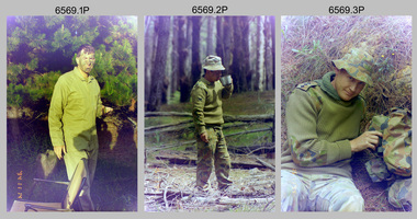
This is a set of 30 photographs of 4th Field Survey Squadron personnel undergoing regimental training in 1994, at Second Valley Conservation Park in South Australia. The aim of Exercise ‘Fuggy Hollow’ was typically to provide personnel a practical knowledge of infantry and minor tactics (IMT) at the section level, navigation and map reading, RATEL and survival in the Field.This is a set of 30 photographs of 4th Field Survey Squadron personnel undergoing regimental training in 1994, at Second Valley Conservation Park in South Australia. The colour photographs are on 35mm negative film and are part of the Army Survey Regiment’s Collection. The photographs were scanned at 96 dpi. .1) - Photo, colour, 1994. Unidentified soldier. .2) - Photo, colour, 1994. CPL Phuc ‘Charlie’ Tran. .3 to .5) - Photo, colour, 1994. CAPT Chris Topovsek. .6) & .7) - Photo, colour, 1994. Unidentified soldiers. .8) - Photo, colour, 1994. L to R: SPR Fran Calvert, unidentified (x2), SPR Mark Linford, unidentified. .9) to .17) - Photo, colour, 1994. Unidentified soldiers. .18) & .19) - Photo, colour, 1994. L to R: LT Andrew Caudle, SSGT Brian Collings, OC Maj Peter Demaine. .20) - Photo, colour, 1994. WO2 Peter Hammer. .21) - Photo, colour, 1994. L to R: CAPT Chris Topovsek, SSGT Brian Collings, WO2 Peter Hammer .22) - Photo, colour, 1994. SSGT Brian Collings. .23) - Photo, colour, 1994. L to R: unidentified, SPR Fran Calvert. .24) - Photo, colour, 1994. L to R: SPR Mark Sinderberry, SGT Steve McGuiness, unidentified. .25) - Photo, colour, 1994. SPR Mark Linford. .26) - Photo, colour, 1994. L to R: unidentified (x2), SPR Fran Calvert, unidentified. .27 & .28) - Photo, colour, 1994. L to R: SSGT Brian Collings, WO2 Peter Hammer. .29) - Photo, colour, 1994. WO2 Simon ‘Andy’ Capp. .30) - Photo, colour, 1994. SGT H. Evertz..1P to .30P – There are no personnel identified. ‘1994 EX FUGGY HOLLOW (IMTs) Second Valley Conservation Park’ annotated on negatives sleeve.royal australian survey corps, rasvy, 4 fd svy sqn -
 Bendigo Historical Society Inc.
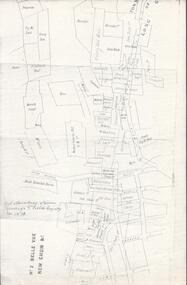
Map - BELLE VUE NO 2 - PLAN OF LEASES
... BHS Collection MAP Bendigo mining plan Belle Vue No 2 No 2 ...BHS CollectionPlan of Mining Leases from Rowan Street to Long Gully. Reference J. N. Macartney 2nd Edition Bendigo Goldfields Registry for 1872. Names of Leases are: Moore ?, Ellesmere Co, Bonati & Co, Dennis, Abe Lincoln Co, Lansell & Hunt, Black & White Lead Co, Koch & Hildebrand, Ballerstedt, Lazarus Co No 1, Lazarus Co, Watson, Lazarus Freehold, Lazarus Co No 2, Lazarus Tribute, South Extended Burra, Endeavor Co, Old Chum Co, Burrows and Sterry, New Chum & Victoria Trib, Jackson, North Old Wybrants Chum Co, Myra Co, McLenn, Geary & Co, Western Victoria Hill G. M. Co, Victoria Reef G.M.Co, South Adventure Co, South Try Me Well, W. Rae, Wells Midway, Extended Co, Handy Andy, Moonta Co, Humboldt Co, Adventure Co, Try Me Well, Sterry & Co, Midway, Tudor, Friedman's Reef, Rising Sun, Try Me Luck, Pomponia, Confidence Co, Alfred Co, Advance Co, Prince Alfred Co, Canterbury Co, Platus Co, S. Platus Co, Golden Fleece United, Alfred Co, Iron Duke Co, Victoria Gold Mines Co, Hercules Co and Iron Bark. Notes prepared by Albert Richardson.map, bendigo, mining plan, belle vue no 2, no 2 belle vue new chum & c, j n macartney bendigo goldfields registry 1872, moore ?, ellesmere co, bonati & co, dennis, abe lincoln co, lansell & hunt, black & white lead co, koch & hildebrand, ballerstedt, lazarus co no 1, lazarus co, watson, lazarus freehold, lazarus co no 2, lazarus tribute, south extended burra, endeavor co, old chum co, burrows and sterry, new chum & victoria trib, jackson, north old wybrants chum co, myra co, mclenn, geary & co, western victoria hill g. m. co, victoria reef g.m.co, south adventure co, south try me well, w. rae, wells midway, extended co, handy andy, moonta co, humboldt co, adventure co, try me well, sterry & co, midway, tudor, friedman's reef, rising sun, try me luck, pomponia, confidence co, alfred co, advance co, prince alfred co, canterbury co, platus co, s. platus co, golden fleece united, alfred co, iron duke co, victoria gold mines co, hercules co, iron bark -
 Bendigo Historical Society Inc.
Document - TYSON'S LINE - EASTERN LINES
... BHS Collection MINING Parish Map Tyson's Line Eastern Lines ...BHS CollectionTyped carbon copy and typed copy of General notes on the lines East of the Hustlers. Lines mentioned are: Hustler's, New Chum, Lightning Hill, Tysons, Slaughteryard, Isabella Mine, Ironstone Hill Reef, Nicholson Reef, on which a mine owned by a man named Stevenson mined a fair amount of gold. Ref. Anon; 1899. Spec. Ed. Aust. Min. Stand. June 1st 1899: p 61. Notes prepared by Albert Richardson.mining, parish map, tyson's line, eastern lines, hustler's, new chum, slaughteryard line, lightning hill, tyson's, isabella mine, ironstone hill reef, nicholson reef, mr stevenson, aust min stand 1 june 1899 -
 Bendigo Historical Society Inc.
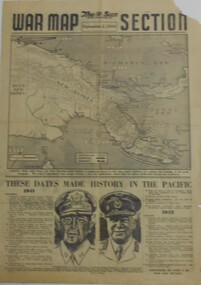
Newspaper - NEWSPAPER COLLECTION: THE SUN WAR MAP SECTION 1944
... NEWSPAPER COLLECTION: THE SUN WAR MAP SECTION 1944... in the Pacific) Newspaper NEWSPAPER COLLECTION: THE SUN WAR MAP SECTION ...The Sun - September 2, 1944 (War in the Pacific)newspaper, worl war ii -
 Wangaratta RSL Sub Branch
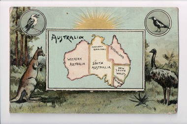
Postcard, 1917
From the album of WWI soldier William West (1268) of the 29 Infantry Battalion, 5th Pioneers Battalion. This collection of postcards, photographs and clippings were sent between William and his family and loved ones during the years he was on active service. See also 207 and 220. Colour postcard, blue / green colour scheme. Map of Australia in central frame surrounded by native Australian animals in a bush setting: kangaroo, emu, currawong / magpie, kookaburra. Above them is a rising sun. The central frame is actually a flap but whatever it may have concealed beneath is now lost. Handwritten message on back.album, photo album, newspaper clippings, postcard, wwi, magpie, currawong, kookaburra, emu, kangaroo, australia -
 Wangaratta RSL Sub Branch
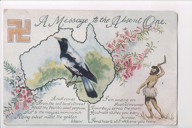
Postcard, 1917
From the album of WWI soldier William West (1268) of the 29 Infantry Battalion, 5th Pioneers Battalion. This collection of postcards, photographs and clippings were sent between William and his family and loved ones during the years he was on active service. See also 207 and 220. Colour postcard featuring a poem, a map of Australia, a currawong or magpie, a swastika, an aboriginal man holding a boomerang or throwing stick. Handwritten message on back.Front: "A message to the absent one"album, photo album, newspaper clippings, postcard, wwi, australian flag, boomerang, throwing stick, magpie, currawong, swastika -
 Bendigo Historical Society Inc.
Document - MINING REPORTS - MAP OF PART OF THE BENDIGO GOLDFIELD INCLUDING WHITE HILLS AND EAGLEHAWK
BHS CollectionMap of part of the Bendigo Goldfield including White Hills and Eaglehawk. Map shows reef lines, gullies, railway line, tram route, type of rock, name of mine, Calls and Dividends. Also Deepest Mine Victoria Quartz 4614 ft. Names of Mines are Garden Gully United, Great Ext'd Hustlers, Johnson's Reef, South New Moon, New Moon, Catherine Reef, Virginia, Central Red White & Blue, Ironbark, Kock's Pioneer, Carlisle and the Hercules & Energetic. Map is part of the Albert Richardson Collection of mining documents and research. document, gold, mining reports, mining reports, map of part of the bendigo goldfield including white hills and eaglehawk, pabst bendigo goldfield, garden gully united, great ext'd hustlers, johnson's reef, south new moon, new moon, catherine reef, virginia, central red white & blue, ironbark, kock's pioneer, carlisle, hercules & energetic. victoria quartz -
 Bendigo Military Museum
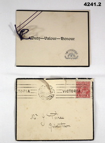
Card - SYMPATHY CARD and ENVELOPE, Atlas Press Marlborough series, printed in Australia, 1917
Items relate to George Frederick Pierce DCM. Refer Cat No 4136P for his service details, award and death. Part of the collection of William (Bill) Thomason, refer Cat No 4136P for more items..1) Four page folding card, front has an embossed map of Australia, central in gold a scroll, Rising Sun, crown and a wreath. Inside has a short poem headed by “Greater love hath no man than this”, next page a brief sympathy message, under in ink an entry by hand. A small string holds the pages together. .2) yellowish envelope with black edging, mail stamps and a 1 penny red stamp. Envelope dated 21 Nov ....... .1) On the front “ Duty - Valour - Honour”. Inside in ink from, ”Mr and Mrs F Stevens"sympathy, cards, military -
 Bendigo Historical Society Inc.
Map - STRUGNELL COLLECTION: HUSTLER'S Royal Reserve Shaft No. 2 Bendigo, September 1913
... shafts Map STRUGNELL COLLECTION: HUSTLER'S Royal Reserve Shaft ...Map, Hustler's Line of Reef, Hustler's Royal Reserves No. 2 Co, Longitudinal Section.Plate No.V111 (8). Bulletin No 33 Signed H.A.Whitelaw Underground survey Office Bendigo September 1913 Drawing shows mine shaft to over 1746 feet deep and appears to show samples of connecting horizontal shaftsUnderground Survey Office, Bendigo.map, bendigo, hustler's royal reserve no. 2 mine* -
 Kew Historical Society Inc
Photograph, J E & B L Rogers, Stables, 'Roseneath', Pakington Street, c.1959
This work forms part of the collection assembled by the historian Dorothy Rogers, that was donated to the Kew Historical Society by her son John Rogers in 2015. The manuscripts, photographs, maps, and documents were sourced by her from both family and local collections or produced as references for her print publications. Many were directly used by Rogers in writing ‘Lovely Old Homes of Kew’ (1961) and 'A History of Kew' (1973), or the numerous articles on local history that she produced for suburban newspapers. Most of the photographs in the collection include detailed annotations in her hand.The Rogers Collection provides a comprehensive insight into the working habits of a historian in the 1960s and 1970s. Together it forms the largest privately-donated collection within the archives of the Kew Historical Society.'Roseneath' was constructed in stages in the I850s by John Ambrose Kitchen, a soap-maker. In 1870 the brick house received an N.A.V. of £60 while in 1885 it was purchased by Edward John Dunn, a geologist. A new wing was built at the right side of the house and several rooms as well as the coach house, loft and groom's quarters were added. In 1903, during Dunn's ownership, the property was described as having eight roorns. The garden is recorded as having been designed by Baron von Mueller who was the Government Botanist from 1853. Source: City of Kew Urban Conservation Study, 1988"32"historic houses -- kew (vic.), roseneath -- pakington street -- kew (vic.) -
 Bendigo Military Museum
Journal - Desert Exploration - Extract from Northern Territory Lands and Survey Dept Annual Report 1960-61, Northern Territory Lands and Survey Branch, 1961
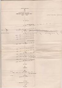
This Extract from Northern Territory Lands and Survey Dept Annual Report 1960-61 is about Desert Exploration between Wave Hill and Tennant Creek. The 2 x fold out maps are 1:1,000,000 scale with one showing a Levelling Traverse. The exploration took place during March and April 1960. This document has been included in the RASvy collection because it was valuable information that was needed by RASvy surveyors who were required to operate in the area in later years.5 x foolscap sized pages and 2 x map foldout pages held together with a slide clip. Pages and maps are two hole punchedroyal australian survey corps, rasvy, fortuna, army survey regiment, army svy regt, asr -
 Bendigo Military Museum
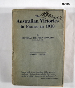
Book - FRANCE, ARMY WW1, Lieutenant General Sir John Monash, "THE AUSTRALIAN VICTORIES IN FRANCE IN 1918", First edition 1920, Second revised edition 1923. 1928
From the front cover; "Intense pride in the Australian Soldier glow in/ this book Sir John doubts whether there is any/ parallel in military history to their performance"/ Daily Graphic (London)." Part of the "William (Bill) THOMASON" Collection. Refer Cat. No. 4136P for more items.Soft cover book. Cover - cardboard, mid grey colour with dark blue colour print on front and back. Black colour print on spine. 336 pages - cut, plain, white colour paper. Illustrated - front end papers - black and red print map of a battle. Back end papers - black and red print map of a campaign. Handwritten signature - front cover and second page from front, price notation - top of page.Handwritten signature - black ink pens - illegible. Price notation - grey lead pencil - "$ 30c"publications, books, ww1, france, monash, william (bill) thomason -
 Bendigo Military Museum
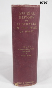
Book - PICTORIAL, WW1, C.E.W. BEAN and H.S. GULLET, "OFFICIAL HISTORY OF AUSTRALIA IN THE WAR OF 1914-18", 1937
From page before title page. "OFFICIAL/ ISTORY/ OF/ AUSTRALIA/ IN THE WAR/ OF 1914-18. VOL. X11/ PHOTOGRAPHI/ RECORD/ OF/ THE WAR". Part of the "William (Bill) THOMASON Collection." Refer Cat No. 4136P for more items.Hard cover book. Cover - cardboard, dark red colour buckram with gold print on spine. Pages are not numbered. White colour glossy paper, cut, plain. Pages 1 to X - Preface. Pages 1 to 753 - Illustrations, black and white photographs and maps at back - index.william (bill) thomason, publication, book, ww1, photographs -
 Bendigo Military Museum
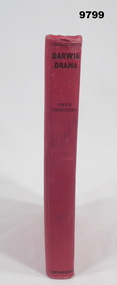
Book - DARWIN STORIES, WW2, Owen Griffiths, "DARWIN DRAMA", c.1942
"DARWIN DRAMA" FROM THE FOREWORD. Stories from " .... Australia, for the first time/ in her history suffered a blow upon her native soil from enemy action, ...." Part of the William (Bill) THOMASON Collection. Refer Cat No. 4136P for more items.Hardcover book, Cover - cardboard, red colour buckram, black colour print on spine. 218 pages - cut, plain, off white colour paper. Illustrated black and white photographs, maps and sketches.Handwritten information - grey lead pencil, "$20/ BAYx".william (bill) thomason, publications, books, ww2, darwin -
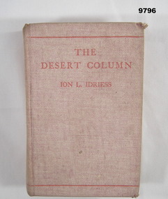 Bendigo Military Museum
Book - DIARY, WW1, Ion L Idriess (Late Trooper 5th Light Horse AIF), "THE DESERT COLUMN", 1932
From Title page, "THE DESERT COLUMN/ LEAVES FROM THE DIARY OF AN AUSTRALIAN/ TROOPER IN GALLIPOLI, SINAI AND / PALESTINE". Part of the William (Bill) THOMASON Collection. Refer Cat. No. 4136P for more items.Hardcover Book. Cover - cardboard with light red colour buckram, red colour print on front and spine. 338 plus 24 pages, cut, plain, off white colour paper. Illustrated - front end papers - black ink print diagram of Gallipoli and sketch map of Sinai desert. Back end papers - black ink, print, sketch map of Palestine fighting. publications, books, ww1, diary -
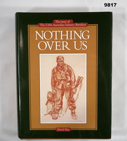 Bendigo Military Museum
Book - BATTALION HISTORY, WW2 - ARMY, David Hay, "NOTHING OVER US", 1984
From the title page - "NOTHING OVER US/ The story of/ The 2/6th Australian Infantry Battalion" Part of the "William (Bill) THOMASON" Collection. Refer Cat. No. 4136P for more items.Hardcover book with dust cover. Cover - cardboard, mid brown colour buckram, gold colour print on spine. Dust cover - paper, white and dark green colour print on front and spine on dark green, mid brown and cream colour background. Front illustration - brown colour crayon drawing of an Australian soldier. Flaps - white colour printed information. 604 pages, cut, plain white colour paper. Illustrated black and white and colour photographs, maps and drawings. End papers - front and back - sepia toned photograph of troops on Parade, background streetscape of trees and tram. publications, books, history 2/6th infantry battalion, william (bill) thomason collection -
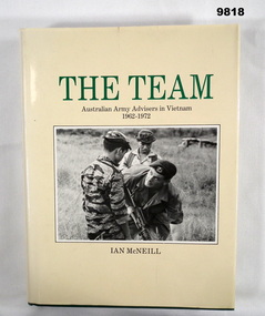 Bendigo Military Museum
Book - VIETNAM, Ian McNEILL, "THE TEAM", 1984
From the Title page - "THE TEAM/ AUSTRALIAN ARMY ADVISERS/ IN VIETNAM 1962-1972" Part of the "William (Bill) THOMASON" Collection. Refer Cat No. 4136P for more items.Hardcover book with dust cover. Cover - cardboard, green colour buckram, gold colour print on spine. Dustcover - paper, green and black colour print on front and spine on cream colour background. Front illustration - black and white photograph of three soldiers. Flaps with black print information. 534 pages - cut, plain, white colour paper. Illustrated black and white photographs and maps. End papers - front and back - brown beige colour map.publications, books, vietnam, army, william (bill) thomason collection -
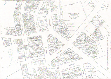 Bendigo Historical Society Inc.
Map - LONG GULLY HISTORY GROUP COLLECTION: LONG GULLY
Copy of a map of Long Gully area with some street names, size of allotments, number, measurements, date and names.bendigo, history, long gully history group, the long gully history group - long gully, housing commission, housing act 1958, gazette -
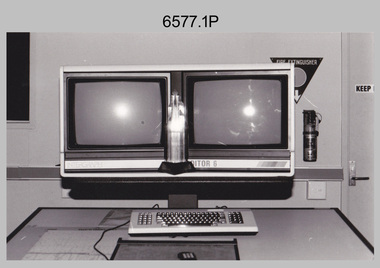 Bendigo Military Museum
Photograph - AITA Award - RA Svy’s AUTOMAP 2 Computer Based Map Production System, Army Survey Regiment, Fortuna, Bendigo, 1984
This collection of three photos of the Australian information Technology Award (AITA) won by the Royal Australian Survey Corps (RA Svy) AUTOMAP 2 computer-based map production system, was taken in 1984 at the Army Survey Regiment, Fortuna, Bendigo. The following article appeared in the ARMY Newspaper on Thursday 21st February 1985. ‘In computerised map production. Survey soldiers lead the world. BENDIGO: Army surveyors have been put on the map as world leaders in computerised map production following the Australian information Technology Awards. RA Svy won the Computer Assisted Draughting – Mapping section for its Automap II System which has created considerable interest among overseas defence experts. The award for the digital mapping system was accepted by OC Air Survey Sqn, MAJ Rob John, who said it was a great morale-booster for the soldiers of the Bonegilla (sic)* -based Army Survey Regiment. "Setting up a state-of-the-art system like Automap II. is an enormous task, " he said. "We started in August 1983 and it's only recently that we have achieved production results. "We were all very pleased to have our efforts recognised in this way. “Of course, credit must also go to the Intergraph Corporation for manufacturing the system and carrying out most of the development." RA Svy is responsible for producing all of Australia's maps used for defence purposes. Its topographical maps have a scale of 1:50,000 or 1:100,000 although Automap II has the capability of producing smaller scale maps - down to 1: 2,000,000. Automap II consists of three computers and three sub-systems: input, raster scanning, and graphic edit. The input sub-system has eight stereo plotters, two interactive graphic workstations and a system manager workstation. The stereo plotters use superimposition optics to digitise features from aerial photographs. It incorporates a voice recognition system so the operator can simply say "House", "Windmill", etc; and the relevant feature will be incorporated in the digital picture. Individual map separations are scanned and converted by the raster scanning sub-system to a digital raster image. This image is then converted to a graphics file in Intergraph format.’ *Note – the Army Survey Regiment was located in Bendigo, not Bonegilla as incorrectly stated in the article. The article appears on Page 137 of Valerie Lovejoy’s book 'Mapmakers of Fortuna – A history of the Army Survey Regiment’ ISBN: 0-646-42120-4. Additional history of the AUTOMAP 2 system with historic photographs is covered in pages 119, 137-143 and 157 of the 'Mapmakers of Fortuna’ book. See item 6223.23P for additional history and photographs of the AUTOMAP 2 system.This collection of three photos of the Australian information Technology Award (AITA) won by the Royal Australian Survey Corps (RA Svy)’s AUTOMAP 2 computer-based map production system, was taken in 1984 at the Army Survey Regiment, Fortuna, Bendigo. The photographs are printed on photographic paper and are part of the Army Survey Regiment’s Collection. The black and white photographs were scanned at 300 dpi. .1) - Photo, black & white, 1984, AITA Award sitting between the dual screens of an AUTOMAP 2 Graphic Edit Workstation. .2) - Photo, black & white, 1984, MAJ Job Johns (centre) and two of Intergraph Corporation IT engineers proudly hold the AITA Award next to an AUTOMAP 2 Graphic Edit Workstation. .3) - Photo, black & white, 1984, The AITA Award displayed on a pedestal in the Army Survey Regiment Officers Mess. .1P to .3P –No personnel are identified. ‘AITI Award to AUTOMAP II 1984’ annotated on cover sleeve. royal australian survey corps, rasvy, army survey regiment, army svy regt, fortuna -
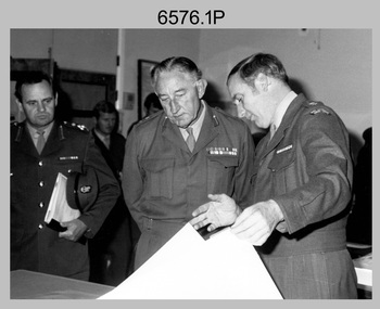 Bendigo Military Museum
Photograph - Visit by MAJGEN David Engel AO OBE, to the Army Survey Regiment, Fortuna, Bendigo, 1982
This set of three photographs was taken the 30th of August 1982 during a visit to the Army Survey Regiment, Bendigo by the Deputy Chief of the General Staff - Major General David Frederick Walter Engel AO, OBE. As there are no annotations on the photo, the name of the Brigadier is unknown. LTCOL Peter Eddy was the CO of the Army Survey Regiment from 1981 to 1992 and handed over to LTCOL Jorge Gruszka, who commanded the unit from 1982 to 1985.This is set of three photographs taken on the occasion of a visit to the Army Survey Regiment, Bendigo by the Deputy Chief of the General Staff - Major General David Frederick Walter Engel AO, OBE on the 30th of August 1982. The black and white photograph was printed on photographic paper and are part of the Army Survey Regiment’s Collection. The photographic print was scanned at 300 dpi. .1) - Photo, black & white, 1982. Map production brief - L to R: unidentified Brigadier, unidentified visitor in background, MAJGEN David Engel AO OBE, CO LTCOL Peter Eddy. .2) - Photo, black & white, 1982. MAJGEN David Engel AO OBE views stereo aerial photography on a Wild B8 stereo plotter. .3) - Photo, black & white, 1982. Aerial photography brief - L to R: MAJGEN David Engel AO OBE, CO LTCOL Peter Eddy..1P to .3P –No personnel are identified. ‘Visit to ASR by MAJGEN Engel 30 Aug 1982’ annotated on cover sleeve.royal australian survey corps, rasvy, army survey regiment, army svy regt, fortuna -
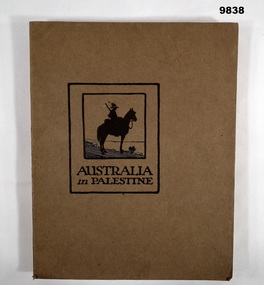 Bendigo Military Museum
Book - PALESTINE, WW1, Angus & Robertson Ltd, Military Publisher, "AUSTRALIA IN PALESTINE", 1919
Part of the William (Bill) THOMASON Collection. Refer Cat. No. 4136P for more items.Soft cover book. Cover - Brown colour cardboard, black colour print on front and back. Illustrated- front - silhouette sketch in black and blue colour ink, soldier on horseback. 153 pages - cut, plain, off white colour paper. Illustrated, black and white, sepia and colour plates of photographs, maps, diagrams and cartoons. End papers - front and back - illustrated silhouette sketch of soldiers mounted on camels in a line within a landscape of flat hills, two palm trees and a grave cross.publications, books, ww1, palestine campaign, william (bill) thomason collection -
 Bendigo Historical Society Inc.
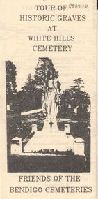
Document - BENDIGO CEMETERIES COLLECTION: SELF GUIDED TOUR HISTORIC GRAVES WHITE HILLS CEMETERY DOCUMENT
BHS CollectionLemon coloured trifold document : Tour of Historic Graves at White Hills Cemetery. Friends of the Bendigo Cemeteries. Map of White Hills Cemetery (1854 - 1993 ) showing marked grave sites with descriptions. E.g. Charles Merri Bux - 'Black Charlie' Indian hawker of Bendigo. History of White Cemetery on back page.Friends of Bendigo Cemeteriesbendigo, cemetery, white hills cemetery -
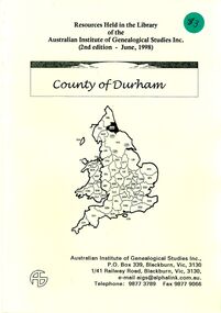 Bendigo Historical Society Inc.
Book - STRAUCH COLLECTION: COUNTY OF DURHAM
... , 20 pages with a map. Book STRAUCH COLLECTION: COUNTY ...BHS CollectionBooklet Resources Held in the Library of the Australian Institute of Genealogical Studies Inc. (2nd edition - June, 1998) County of Durham, 20 pages with a map.genealogy, family, durham, uk-durham-genealogy -
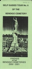 Bendigo Historical Society Inc.
Document - BENDIGO CEMETERIES COLLECTION: SELF GUIDED TOUR NO. 6 DOCUMENT
BHS CollectionGreen trifold document: Self Guided Tour No. 6 of the Bendigo Cemetery. Friends of the Bendigo Cemeteries 2000 - 2001. Theme : Federation: 100 years later, our Heritage. Map with 26 numbered graves, includes J.C.T. Ballerstedt, Christiana Atkinson ( Dr. Atkinson buried 4 wives in this cemetery ) John Dumphy miner of Hustler's reef, erected by Bendigo Miners Accident Society.Friends of the Bendigo Cemeteries Inc 2000bendigo, cemetery, bendigo cemetery tour -
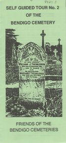 Bendigo Historical Society Inc.
Document - BENDIGO CEMETERIES COLLECTION: SELF GUIDED TOUR NO.2 DOCUMENT
BHS CollectionGreen trifold document: Self guided tour no 2 of the Bendigo Cemetery. Friends of the Bendigo Cemeteries. Front cover shows headstone of William J. Trebilcock. Map of cemetery with 28 graves numbered and described e.g. Joel Horwood, wealthy mine owner, Robert Haverfield, founder Bendigo Advertiser, Sir John Quick, Bishop Langley.Friends of Bendigo Cemeteriesbendigo, cemetery, bendigo cemetery tour -
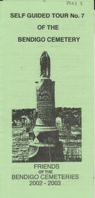 Bendigo Historical Society Inc.
Document - BENDIGO CEMETERIES COLLECTION: SELF GUIDED TOUR NO. 7 DOCUMENT
BHS CollectionGreen trifold document: Self Guided Tour No. 7 of the Bendigo Cemetery, friends of the Bendigo Cemeteries 2002 - 2003. Theme is tombstones erected not by family but by public subscriptions or through societies. Numbered map showing described grave sites.Friends of Bendigo Cemeteries 2002bendigo, cemetery, bendigo cemetery tour -
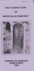 Bendigo Historical Society Inc.
Document - BENDIGO CEMETERIES COLLECTION: SELF GUIDED TOUR WHITE HILLS CEMETERY DOCUMENT
BHS CollectionLilac coloured trifold document: Self guided tour of White Hills Cemetery, Friends of Bendigo Cemeteries 1995. Map with numbered grave sites e.g. Large Jewish section with over 80 known burials. Graves of Afghan traders,Friends of Bendigo Cemeteries, 1995bendigo, cemetery, white hills cemetery tour