Showing 11020 items matching " land"
-
 Canterbury History Group
Document - Canterbury Bowling Club - Agreement, 1935
Agreement between The Mayor, Councillors and Citizens of the City of Camberwell and Messrs A.G. Greenham and A .McK. Hislop, trustees of the Canterbury Bowling Club, 1935. Includes map of land to be occupied.canterbury bowling club, kendall street, city of camberwell, scott street, canterbury gardens, greenham> arthur george, hislop> arthur mckenzie, maps, canterbury -
Lakes Entrance Historical Society
Book, Calder Stuart and Winty, East Cunninghame and Lake Tyers Beach. A case study Report, 1976
A case history of resort development in the Lake Tyers Beach Victoria coast area, considering the history of land use and future planning with regard to environmental impact and social requirements.natural history, land settlement -
 Lakes Entrance Historical Society
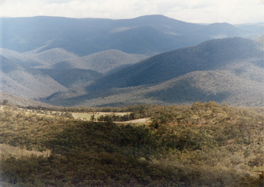
Photograph - Suggan Buggan, Tambo Shire, 1994 c
Also second identical copyColour photograph of the scenery in Suggan Buggan, showing very heavily forested mountainous country, a small area of cleared land centre left foreground. Suggan Buggan Victoriasettlement, agriculture, topography -
 Bacchus Marsh & District Historical Society
Map, Maddingley Township, Parish of Parwan, County of Grant, 1856
Maddingley is a locality or township within the broader township area of Bacchus Marsh. This map is dated 1856 but is based on an earlier survey in 1843. The main area of Maddingley shown on this map is an area bounded by Bacchus Street, Moore Street, Griffith Street and Franklin Street. Other streets visible are Inglis Street, Labilliere Street, McCrae Street. The area to the east of Franklin Street is not sub-divided and is described as an 'alluvial flat. A single page paper map showing land allotments, streets, and natural watercourses in the township of Maddingley. The map is pasted into a bound volume containing 76 maps or plans in total. Two inscriptions: 1. A.J. Skene Surveyor, 1843. ; 2. Surveyor-General's Office Melbourne, Sept 6, 1856. (Lithographed by R. Meikle)bacchus marsh victoria maps, maddingley victoria maps, land use, maddingley victoria history -
 Bendigo Historical Society Inc.
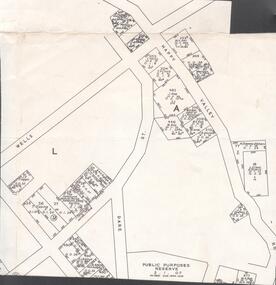
Map - VICTORIA HILL - MAP - HAPPY VALLEY RD - DARE ST
Small map showing some blocks of land in the Happy Valley Road, Dare Street and Wells Streets area. Three of the blocks are in the name of Rae. Notes by Albert Richardson.map, bendigo, victoria hill, victoria hill, victoria hill - map - happy valley road - dare street, w rae, j rae -
Lakes Entrance Historical Society
Book, Paul Kelly & Associates, East Gippsland Shire Code of Practice July 2003, 2003
Code of practice detailing minimum acceptable standards of work on land managed , works includes construction works regular maintenance contractors and provision of services East Gippland Victoriavegetation, fire brigade -
 Bendigo Historical Society Inc.
Document - MARKS COLLECTION: HISTORY OF FORTUNA
Four pages typewritten history of Fortuna Villa from Mr. Ballerstedt purchasing the mine and land from the Wittscheibe Brothers to the subsequent sale to George Lansell and the various developments.place, fortuna, fortuna villa -
 Ringwood and District Historical Society
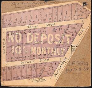
Map, The Ringwood Estate - Second Sub-Division, Ringwood, Victoria - 1919
Three cardboard-backed copies of map clipped from land sale auction brochure. Subdivision includes Warrandyte Road, Tamar Street, Mersey Street and Derwent Street.H.C. Crouch BCE, Licensed Surveyor, 443 LtCollins Street, Melbourne. Handwritten real estate notations in margins and on some allotments include sales information and reference LP7604 - Part of Crown Allotment 31B. Auction date June 14th, 1919. -
 Bendigo Historical Society Inc.
Photograph - The Wilkin Family of Sedgwick, 1800s-1900s
The Phil Wilkin Collection contains a series of 11 Items. The related items can be found by clicking on the reference link below. The following history of the Young family and their descendants who lived at the Springs is provided by Phil Wilkin. His Great Grandparents were Frances Young and August Wirth. Phil has also provided notes on the Wilkin Family and some history of the gold mining in Sedgwick. Frances Young's parents Joseph and Margaret Young owned the property called "The Old Place, Preston Vale or Wellington Flat" at Sedgwick near the Springs. Joseph Young owned and Managed the Standard Brewery which was located at Campbells Creek during the late 1800’s early 1900’s. Joseph and Margaret are buried in the Harcourt cemetery. In 1880 August Wirth lived at Mosquito Creek (Lake Eppalock, Victoria) when he married Frances Young. In 1902 they moved to part of Joseph Young's property. They milked cows and sold cattle for a living. One of their children Charles Wirth (Phil Wilkin's Grandfather) bought the land in 1935 after his parents had died. Charles Wirth was a councillor and also was president of the Shire of Strathfieldsaye. The "Old Place" was part of the property owned by members of the family. The old house at the Springs was burnt out by bushfire in January 1944 and much of the stonework was later vandalized by campers. The original Coliban Water Works were designed in 1863 by the Irish engineer Joseph Brady. The system included 70 kilometres of open water channels, aqueducts, syphons and tunnels to carry water (by gravity) from the Coliban River at Malmsbury, north to Castlemaine and Bendigo. Sedgwick is a locality in Central Victoria, Australia. It is located in the City of Greater Bendigo. Facilities include a public hall that opened in 1958 and CFA Rural fire station. It was named Upper Emu Creek until 1901 when it was renamed as Sedgwick after British geologist Adam Sedgwick.17 photos and historical document of the Wilkin Family associated with the Springs near Sedgwick. There are 182 photos in this series and can be found at 8683.1 to 8683.11. The series also includes photos of the surrounding farming land and the remains of an old house. There are also some notes on the pioneers of the district.history, bendigo, coliban water, joseph brady, irrigation, the springs, sedgwick, phil wilkin collection, standard brewery campbells creek, joeseph and margaret young, wilkin family -
 Kiewa Valley Historical Society
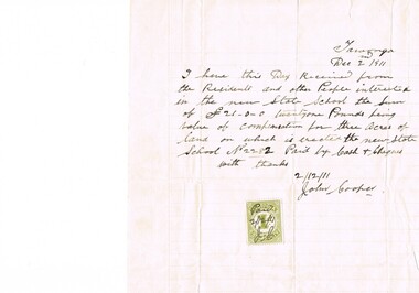
Letter Commerce, Confirmation of Payment, 02/12/1911
This document (dated 1911), is a receipt covering the compensation for the three acres of land required to establish the Tawonga School from its original site (since 1880) to a more central site (since 1911), within the township. This receipt clearly shows the era in which the community involvement and social commitment of landholders was at a higher level, in the early 20th century, than at the latter part. Matters involving community welfare in relatively isolated rural regions was of high priority to every person whether town folk or grazier/farmer or miner. The letter of acceptance of the amount of twenty one pounds for three acres was signed by John Cooper on behalf of Ada Ryder (parent at the school), did not require State Government Compulsory Acquisition process (as it may have, had it been in the latter part of the century and if it were in a city or large town. This social benevolency was part of the period (up to the late 1900's) of the rural Australian environment. This was well before international land investments changed the picture of the socio-economics of country towns.A4 letter of confirmation of payment on pre-lined paper and with a margin. Both margin and lines are coloured in light grey. The page has been folded four times and shows faintly, horizontal lines, of manufacture. The letter is framed with a glass front.This receipt for the compensation of money is hand written in ink and reads: "Tawonga Dec 2 1911, I have this Day Received from the Residents and other People interested in the new State School the Sum of (Pounds sign) 21-0-0 twentyone Pounds being value of compensation for three Acres of land on which is erected the new State School No.2282 Paid by Cash & Cheques with thanks 2/12/11 (Signed) John Cooper" Below this is affixed a Victoria 1 pence stamp duty stamp, on which is written(freehand) Paid 2/12/11 Initialed J Cfinancial letters, receipts, school acquisitons, stamp duty -
 Bendigo Historical Society Inc.
Document - H. A. & S. R. WILKINSON COLLECTION: CONTRACT OF SALE
Contract of sale of land dated 4th August, 1951 between Mr. R. J. Eddy (vendor) and Mrs. E. R. Tieman (purchaser). Property: land being part of Crown allotment 18 section 54C Parish of Sandhurst City of Bendigo, land comprised in certificate of title volume 7150 folio 1429983 and situate No. 30 Gratten Street, Bendigo, together with 5 roomed weatherboard dwelling, all sundry outbuildings, also all linen roller blinds, all linos on floors, gas bath-heather, gas copper, electric sink heather and all wire doors and windows screens. Price: 2,425 pounds.organization, business, h.a. & s.r wilkinson real estate -
 Bendigo Historical Society Inc.
Document - H. A. & S. R. WILKINSON COLLECTION: CONTRACT OF SALE
Conditions of sale by private contract dated 10th January, 1948 between Mrs. E. L. Gunn (vendor) and Mr. K. C. Turner (purchaser). Property: land situate No. 90 Ophir Street corner Rowan street, Bendigo, at present occupied by Mr. Sharp as tenant, being allotment 20 section 22S Parish of Sandhurst City of Bendigo land described in right to occupy residence area No. 4873, together with 6 roomed weatherboard dwelling, all sundry outbuildings on said land, except any of such outbuildings belonging to the tenant. Price: 450 pounds. Attached 3 hand written notes and 1 typed detailing repairs done to the property.organization, business, h.a. & s.r wilkinson real estate -
 Bendigo Historical Society Inc.
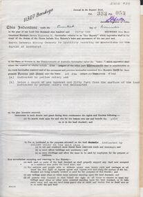
Document - MCCOLL, RANKIN AND STANISTREET COLLECTION: INDENTURE NORTH DEBORAH MINING COMPANY, 20th November, 1952
6 page document ' Gold Mining Lease Crown land Number 11307 Bendigo' plus map. Indenture document between Queen Elizabeth 11 and North Deborah Mining Company No Liability, Parish of Sandhurst, dated 20th November, 1952 re Vol 333, Folio 053. Land indicated by yellow on map and below ' a depth of one hundred and fifty feet from the surface of the land indicated by purple colour and delineated on the plan' Document signed by J. Stanistreet, Manager, North Deborah Mining Company No Liability. Map, fixed to document, heading ' Mining District of Bendigo, No. 11307, County of Bendigo, Parish of Sandhurst, Total area 13 acres 2 roods, 11 perches. Map shows large dam on Crown land, transmission line excised 150 ft., written on purple area. Underneath map ' provided that the dam indicated on the said plan is hereby reserved'.bendigo, mining, north deborah mining company -
Tatura Irrigation & Wartime Camps Museum
Painting - watercolour, No 2 Internment Camp, 1945
This painting is for the Museum. It was a gift to me by an ex prisoner, whom I met when he came to Melbourne with Vic, Nicky and others. His name is Luigi Poggioli and he was a most distinguished gentleman, so distinct and well educated that I still remember him clearly (and I do not have a good memory). Perhaps I remember so well because of his kind words in verse on the painting which read :(Translation) "Ungrateful land with handsome race of Italian blood who with their hard work enriched you". Yes I believe I remember so well because of this verse. Extract from a letter from Mrs Tolaini now living in London. She is the Wife of Vittorio Tolaini who was on the Dunera and wrote of his experiences in "Voyage of an Alien" June 1991. Framed watercolour painting - 11 trees in foreground, one small hut facing towards bottom right hand corner, 4 large huts centre of painting, black writing in Italian left and right foreground. Painting by L Poggioli.Front bottom left side: "To Noemi Vendramini for her 21st birthday, January 19,1945. L Poggioli, LP44 No. 2 Internment Camp, Tatura Front bottom right side: 4 lines of Italian writing translated "Ungrateful land with handsome race of Italian blood who with their hard work enriched you"camp 2, mrs tolaini, noemi vendramini, luigi poggioli, dunera boy -
Whitehorse Historical Society Inc.
Document, History of Tally Ho Boys Home, 1972
Three papers on History of Boys Training Farm, Highbury Road, Tally Ho3 papers on History of Boys Training Farm, Highbury Road, Tally Ho, commenced in 1903 by Rev. and Mrs George Cole. The story covers the period from 1903-1930. The farm was built on land bought from Abel Hoadley for 1,000 Pounds near the corner of Springvale Road in Boundary Road (now Highbury Road). 2 letters (16/7/1972 & 28/5/1972) to Nancy Leach from E. Hinneberg, Assistant Superintendent, Tally Ho, about his association with Tally Ho.Three papers on History of Boys Training Farm, Highbury Road, Tally Hoyouth services, tally ho boys home, cole, george, rev., cole, mrs, hoadley, abel, boundary road burwood east, highbury road, burwood east, springvale road, burwood east, leach, nancy, hinneberg, ernest. -
 Bayside Gallery - Bayside City Council Art & Heritage Collection
Map, Department of Crown Lands and Survey et al, Moorabbin, County of Bourke, Government Roads, 1920
The cadastral map of the Parish of Moorabbin in Victoria (L.6104) shows parish boundaries and land ownership 1920 when Sandringham was a Town. The government roads have been coloured in red pencil.moorabbin, county of bourke, map, plan, land subdivision, land titles, foreshores, hampton, beaumaris, highett, cheltenham, department of lands and survey, land owners, cartographic material, brighton, sandringham, town of sandringham, government roads -
 8th/13th Victorian Mounted Rifles Regimental Collection
Photograph
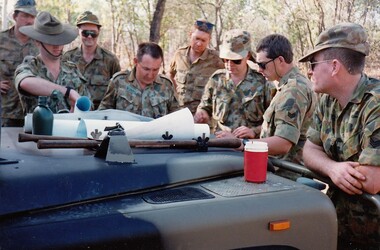
The Dibb Report into mainland defence of Australia,1986, among other things identified the requirement for protection of key assets in Northern Australia and the possibility of involving Army Reserve (Ares) units in this thus releasing regular forces for offensive operations. Dibb also pointed out that this defined role would result in a huge lift in Ares morale. In June 1988, the 3rd Division (3Div) conducted a Tactical Exercise without Troops (TEWT), Exercise ‘Distant Trumpet’ in the Katherine- Darwin area to study problems associated with defence against low level incursions against Tindal RAAF Base. Exercise ‘Northern Explorer’ followed in October of that year when units of the 3Div including A Squadron 8/13 Victorian Mounted Rifles sent patrol groups to get a first taste of environment and conditions. Post-Exercise reports had to include recommendations re: health, equipment and adaptation of Standing Operating Procedures (SOPs) in preparation for the new role deploying to Northern Australia. The first deployment by 8/13 Victorian Mounted Rifles was in 1988. Deployments continued in following years. In September 1993, 3 Troop (Wangaratta) VMR Squadron 4/19 PWLH commanded by Captain Kelvin Robertson deployed to NT. The training began with airfield defence at Tindal followed by a 1000km recon into Arnhem Land in four Landrovers. The troop reported on the conditions of the roads, airfields, bridges (mainly causeways) resources such as fuel supplies in the towns and infrastructure. Each troop taking different route. 3 Troop had the Northern route through Kakadu National park across the East Alligator River to Oenpelli then to Maningrida and Ramangining and south to the Central Arnhem Road and back to Tindal Air force Base. Colour photograph of group of soldiers of VMR Squadron 4/19Prince of Wales's Light Horse studying maps on bonnet of Land Rover during annual exercise in Northern Territory 1994.Major M. Annett wearing slouch hat, Sergeant Gary Wynn,without hat,,on his left. -
 Bendigo Historical Society Inc.
Document - H.A. & S.R. WILKINSON COLLECTION: CONTRACT OF SALE
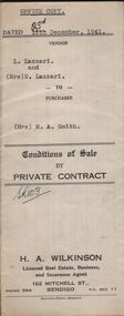
Conditions of sale by private contract dated 23rd December, 1941 between L. Lazzari and Mrs. E. Lazzari (sellers) and Mrs. M.A. Smith (buyer) for land situate No. 18 Burn Street, Golden Square being Crown allotment 8a section 46B land described in Crown grant volume 2325 folio 464944, together with 5-roomed weatherboard dwelling and all sundry. Price 340 poundsorganization, business, h.a. & s.r wilkinson real estate -
 Bendigo Historical Society Inc.
Document - H.A. & S.R. WILKINSON COLLECTION: CONTRACT OF SALE
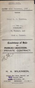
Conditions of sale by private contract dated 23rd December, 1937 between Mrs. E.O. Hosking (seller) and R. Turner & Mrs. A. Turner (buyers) for land situate No.75 Neale Street, Bendigo being Crown allotment 104 section H at Back Creek, being land described in certificate of title volume 4808 folio 961579, together with 5-roomed weatherboard dwelling and all sundry. Price 750 pounds.organization, business, h.a. & s.r wilkinson real estate -
 Bendigo Historical Society Inc.
Document - H.A. & S.R. WILKINSON COLLECTION; CONTRACT OF SALE
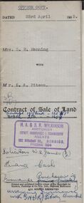
Contract of sale of land dated 23rd April, 1953 between Mrs. L.M. Manning (seller) and Mr. L.A. Pitson (buyer) for land situate 134 Bannister Street, Bendigo being north-east of and about 195 links from allotment 503 section K described in right to occupy residence area right No. 4612, together with 5-roomed weatherboard dwelling and all sundry. Price 1,350 pounds.organization, business, h.a. & s.r wilkinson real estate -
 Bendigo Historical Society Inc.
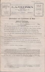
Document - H.A. & S.R. WILKINSON COLLECTION: CONDITION OF SALE
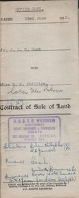
Contract of sale of land dated 23rd June, 1952 between Mr. J.L.C. Hunt (seller) and Miss D.A. Phillips for land being Lot 18 on plan of subdivision No. 14194, being part of Crown allotments 454A and 476 section H described in certificate of title volume 6110, folio 975 situate in Murray Street, Bendigo, together with 50roomed weatherboard dwelling and all sundry. Price 2,525 pounds.organization, business, h.a. & s.r wilkinson real estate -
 Bendigo Historical Society Inc.
Document - H.A. & S.R. WILKINSON COLLECTION: CONDITION OF SALE
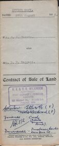
Contract of sale of land issued by H.A. Wilkinson dated 25th August 1953 between Mr. G. A. Harris (seller) and Mr. D.R. Raggatt for land being allotment 15Bsection 51B Parish of Sandhurst City and County of Bendigo described in right to occupy residence area No. 285 and situate No. 88 Old Violet Street Corner Lilac Street Bendigo, with weatherboard dwelling and all sundry. Price 3,800 poundsorganization, business, h.a. & s.r wilkinson real estate -
 Bendigo Historical Society Inc.
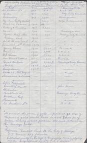
Document - ALBERT RICHARDSON COLLECTION: SHAFTS ALIENATED AND SITES RESERVED BY THE MINES DEPARTMENT
Handwritten one page table of information. On top of page ' Ref. derelict land in the City of Bendigo copied 17.4.62. Shafts alienated and sites reserved by the Mines Dept' List of mines, dates, depth of shaft, receiving body. For example: Londonderry, 1957, 2900 feet, Kindergarten. Reference: 'Derelict Land in the City of Bendigo' P.J. Rimmer and R.J. Johnston. Published jointly by the Dept of Geography, University of Sydney and The Geographical Society of NSW.Albert Richardsonbendigo, mining, derelict land reused -
 Bendigo Historical Society Inc.
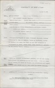
Document - H.A. & S.R. WILKINSON COLLECTION: CONTRACT OF SALE
This business was owned by father and son, Henry Archibald Wilkinson and Samuel Ronald "Ron" Wilkinson. Henry (1882-1954) was born in Shepparton and died in Bendigo. He was married to Grace Hovendon in 1908. Samuel Ronald "Ron" (1914-1995), Henry's son, was married to Florence Jean McKerlie in 1937.Contract of sale of land dated 24th October, 1956 between D.E. Thomas & G.L. Thomas (sellers) and K.P. Robertson (buyer) part of Crown allotment 228A and 228B section A being the whole land described in certificate of title volume 6230 folio 888 and situate at the corner of Creeth and Arms Streets, Long Gully, together with all improvements thereon and all lines, blinds and light fittings. Price 2,300 poundsorganization, business, h.a. & s.r wilkinson real estate -
 Bendigo Historical Society Inc.
Document - H.A. & S.R. WILKINSON COLLECTION: CONTRACT OF SALE
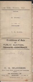
This business was owned by father and son, Henry Archibald Wilkinson and Samuel Ronald "Ron" Wilkinson. Henry (1882-1954) was born in Shepparton and died in Bendigo. He was married to Grace Hovendon in 1908. Samuel Ronald "Ron" (1914-1995), Henry's son, was married to Florence Jean McKerlie in 1937.Conditions of sale by public auction dated 25th January, 1930 between A. Mooney (seller) and T.C. Smith (buyer) for land situate Allingham Street, Golden Square, being described in certificate of registration as residence area No. 20503, together with all buildings on said land. Price 26 pounds. Also account from The Bendigo Advertiser to H.A. Wilkinson for advertising dated 28 January, 1930 for 1 pound 10 shillings.organization, business, h.a. & s.r wilkinson real estate -
 Bendigo Historical Society Inc.
Document - H.A. & S.R. WILKINSON COLLECTION: CONTRACT OF SALE
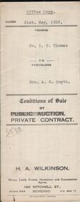
This business was owned by father and son, Henry Archibald Wilkinson and Samuel Ronald "Ron" Wilkinson. Henry (1882-1954) was born in Shepparton and died in Bendigo. He was married to Grace Hovendon in 1908. Samuel Ronald "Ron" (1914-1995), Henry's son, was married to Florence Jean McKerlie in 1937.Conditions of sale by private contract dated 31st May, 1935 between Mr. E.T. Thomas (seller) and Mrs. A.M. Smyth for land, as fenced, situate corner Hargreaves and Wattle Streets, Bendigo, being Crown allotment 25 section 97C described in certificate of title volume 1662 folio 332318. Also land adjoining the above, together with 6-roomed weatherboard dwelling and all sundry. Price 435 pounds.organization, business, h.a. & s.r wilkinson real estate -
 Bendigo Historical Society Inc.
Document - H.A & S.R. WILKINSON COLLECTION: CONTRACT OF SALE
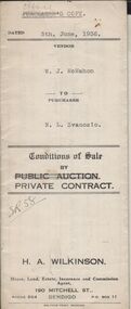
This business was owned by father and son, Henry Archibald Wilkinson and Samuel Ronald "Ron" Wilkinson. Henry (1882-1954) was born in Shepparton and died in Bendigo. He was married to Grace Hovendon in 1908. Samuel Ronald "Ron" (1914-1995), Henry's son, was married to Florence Jean McKerlie in 1937.Conditions of sale by private contract dated 5th June, 1936 between W.J. McMahon (seller) and N.L. Svanosio (buyer) for land situate No. 64 Neale Street, Bendigo being parts of Crown allotments 200 and 201A section H, being the whole of the land remaining untransferred in certificate of title volume 4300 folio 859955, together with 5-roomed weatherboard dwelling and all sundry. Price 400 pounds.organization, business, h.a. & s.r wilkinson real estate -
 Kew Historical Society Inc
Plan - Subdivision Plan, Jas R Mathers Son & McMillan, Clifton Estate, Kew, c. 1916
Pru Sanderson, in her groundbreaking ‘City of Kew Urban Conservation Study : Volume 2 - Development History’ (1988), summarised the periods of urban development and subdivisions of land in Kew. The periods that she identified included 1845-1880, 1880-1893, 1893-1921, 1921-1933, 1933-1943, and Post-War Development. These periods were selected as they represented periods of rapid growth or decline in urban development. An obvious starting point for Sanderson’s groupings involved population growth and the associated economic cycles. These cycles also highlighted urban expansion onto land that was predominantly rural, although in other cases it represented the decline and breakup of large estates. A number of the plans in the Kew Historical Society’s collection can also be found in other collections, such as those of the State Library of Victoria and the Boroondara Library Service. A number are however unique to the collection.The Kew Historical Society collection includes almost 100 subdivision plans pertaining to suburbs of the City of Melbourne. Most of these are of Kew, Kew East or Studley Park, although a smaller number are plans of Camberwell, Deepdene, Balwyn and Hawthorn. It is believed that the majority of the plans were gifted to the Society by persons connected with the real estate firm - J. R. Mathers and McMillan, 136 Cotham Road, Kew. The Plans in the collection are rarely in pristine form, being working plans on which the agent would write notes and record lots sold and the prices of these. The subdivision plans are historically significant examples of the growth of urban Melbourne from the beginning of the 20th Century up until the 1980s. A number of the plans are double-sided and often include a photograph on the reverse. A number of the latter are by noted photographers such as J.E. Barnes.The Clifton Estate was an ambitious subdivision. It included 61 allotments bordering Cotham and Park Hill Roads, and Florence and Adeney Avenues. It is difficult to ascertain the exact year when the ‘Clifton Estate’ was surveyed, subdivided and first auctioned. The uncertainty may be due to allotments being released during the First World War. The subdivision took its name from the house ‘Clifton’ (lot 5) on the corner of Adeney Avenue and Cotham Road. The outline of Clifton (since demolished) and the extent of its land following the subdivision are represented on the plan. The auctioneers have also shown ‘Maryfield’ and ‘Wimba’, the neighbouring properties in Cotham Road, on the plan."B"subdivision plans - kew, clifton estate, cotham road, adeney avenue, florence avenue, park hill road -
 Ballan Shire Historical Society
Map - Map. Korweinguboora, Department of Lands and Survey, Korweinguboora. Counties of Talbot and Grant
A map of the Korweinguboora area showing roads, forests, railway lines and properties with the owners names.The inclusion of the names of landowners is of significance and value to historians.A map of the Korweinguboora area showing land subdivisions and names of owners and other physical features. There is a scale in chains. No date is certain but it could be 1902. The map has been repaired with sellotape.There are various pencil annotations but the are difficult to read.talbot, moorarbool west, wombat, bullarto, korweinguboora, moorarbool east, dean, wombat state forest, barkstead -
Glenelg Shire Council Cultural Collection
Photograph - Photograph - aerial view of Portland, c. 1954
Black and white aerial photograph of coastline around Portland. Black border, scale all sides, 5 rows of 3 't' at regular intervals. Ocean on left, land on rightFront: '607 - 54 ' - handwritten, white, border 'RUN 7' 'PORTLAND', printed, white, borderaerial photography, central portland, portland harbour, south west coastline