Showing 22292 items
matching parks
-
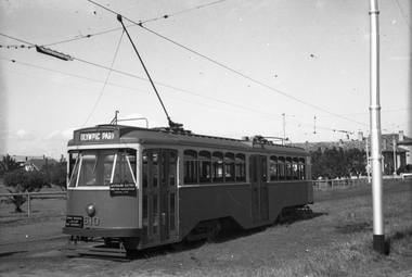 Melbourne Tram Museum
Negative, Wal Jack, mid 1950's
Black and white negative, by Wal Jack, Y1 610 of an AETA tour at Point Ormond, with destination of Olympic Park. Photo possibly mid 1950'strams, tramways, aeta tour, point ormond, y1 class, tram 610 -
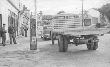 Stawell Historical Society Inc
Photograph, Nalder's garage 1950's
Nalders Garage 1950's at Corner of Patrick Street and Sloane Street Stawell. Showing truck and car parked in front of garage with Plume Petrol Bowserstreetscape, transport, vehicles -
 Port Melbourne Historical & Preservation Society
Document, Rob YOUL et al, Notes and other material on the coal gas industry and Gasworks Park, July 2024
The spiral bound copy of the notes and photographs and story of the coal/gas industry and Gasworks Park was assembled by Rob YOUL and Judy Solomon between 2020 and 2024. gasworks park, built environment - industrial, industry gas & coal -
 Lakes Entrance Historical Society
Photograph, Lakes Post Newspaper, Carpenters Tours Lakes Entrance Victoeia. c1990, 1990 c
Mike and Una Carpenter had a bus initially to take their campers to places of interest soon growing into the business Carpenters Out and About toursBlack and white photograph showing Una Carpenter with holiday makers standing beside small passenger bus at Carpenters Camp Park Lakes Entrance Victoriacaravan parks, tourism, vehicles, social history -
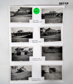 Bendigo Military Museum
Photograph - PHOTOGRAPHIC COLLAGE, c.1954
In 1954 National Services Trainees trained at Puckapunyal.Series of 8 small black and white photos of Tanks parked or in trainings at Army base Puckapunyal in 1954. All are labelled and attached to a piece of A.4 paper.All labelled Army Tanks or Centurion Tank, Puckapunyal 1954.photographs, puckapunyal, tanks -
 Sunbury Family History and Heritage Society Inc.
Photograph, Rosa McCall, Anderson Road, February 2014
The street in the photograph is Anderson Road in Sunbury, looking towards Darbyshire Road and the NW. The driveway with the hoarding on the LHS leads to the former Sunbury Storage Business. The photograph was taken in February 2014.A non-digital coloured photograph of a street with four cars parked along it and an advertising notice on the LHS of the image. Some housing and open areas are visible in the distance.anderson road, darbyshire road, sunbury -
 Buninyong & District Historical Society
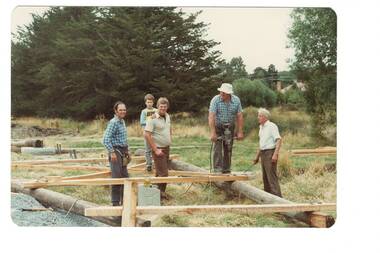
Photograph - Colour photo, Construction of poppet head in deSoza park, Jan. 1992, Construction of poppet head in deSoza park, Jan. 1992
EventsColour photo, Construction of poppet head in deSoza park, Jan. 1992,L to R Graham Gooding, Chris Nichols, Ron Nichols, Ivan Eamesgold king festival, de soza park, poppet head, graham gooding, chris nichols, ron nichols, ivan eames -
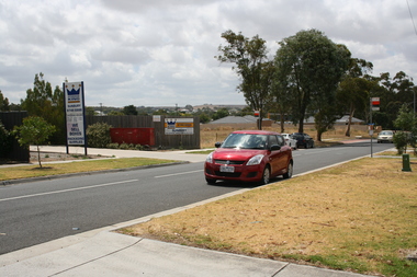
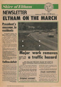 Eltham District Historical Society Inc
Journal - Newsletter, Shire of Eltham, Shire of Eltham newsletter, 1979
... parks ...Articles, some with photos. Subjects include President's message, Eltham-templestowe intersection, indoor recreational centre, Bridge over Watsons Creek, town square, list of councillors, forward planning, recreational faciliaites including Eltham town park, Hurstbridge hall, roads, community welfare services, eltham Community and reception centre opening, amenities for youth, concrete bridge at Arthurs creek and Mitton's Bridge at St Andrew's Newsprint, 4 pages harry gilham collection, intersection, round-about, recreation, recreational centre, watsons creek, town square, councilors, newsletter, planning, parks, hurstbridge hall, community welfare service, roads, eltham community and reception centre, youth, skateboard track, mitton's bridge, arthur's creek, fitzsimons lane, main road, road construction, rondabout -
 Glen Eira Historical Society
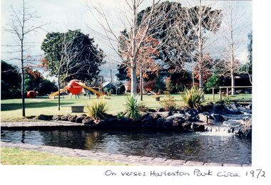
Article - HARLESTON PARK, ELSTERNWICK
This file contains 2 items, viz: 1/Press cutting from the Melbourne Herald (01/06/1974) regarding opposition by some Elsternwick residents to plans by Caulfield Council to install gas barbecues in Harleston Park. 2/Five coloured photographs of the park i.e three glossy prints: on verso of one ‘Harleston Park circa 1972’ and on the others ‘Harleston Park’; two matt prints, on verso of each, ‘Harleston Park, 1982’.harleston park, ross albert, ross mrs albert, brodie william, meldrum frank, wilson kerry, allison road, seymour road, parks and reserves, newspapers, barbecues -
 Greensborough Historical Society
Slide - Photograph, John Ramsdale, Plenty Gorge sign: Slide 50, 1990s
Photograph shows a sign accusing MMBW of taking land for mega park - Plenty Gorge ParkPart of the John Ramsdale collection of slides and audio visual material.Colour photograph scanned from slide.No maker's marks. No caption on slide.plenty gorge metropolitan park, plenty gorge, melbourne and metropolitan board of works -
 Greensborough Historical Society
Slide - Photograph, John Ramsdale, Sports fields at Whatmough Park: Slide 78, 1990s
Photograph shows a park with pole fence in foreground. Part of the sports fields at Whatmough Park Greensborough.Part of the John Ramsdale collection of slides and audio visual material.Colour photograph scanned from slide.No maker's marks. No caption on slide.whatmough park, sports fields -
 Ararat & District Historical Society (operating the Langi Morgala Museum)
Photograph
Photo taken at McDonald Park, Ararat. All three men were involved in the construction of the park.Black and white photograph of three men wearing three-piece suits and hats and standing outside in a bush setting.Written on the back of the photograph: Bob Forster, G. Gossip, Jessie Bail -
 Stawell Historical Society Inc
Photograph, Grampians Gate Caravan Park -- Contruction of the park entrance -- Coloured
Grampians Gate Caravan Park. Timber structure being lowered into place over park entrance.stawell -
 Greensborough Historical Society
Newsletter, Plenty Gorge Metropolitan Park Newsheet No. 1 August 1989, 1989_08
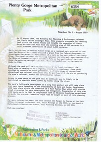
The Shire of Whittlesea obtained a grant from the federal government to investigate the potential development of a park to the west of the Plenty River in 1976. A regional tip site and the Shire of Diamond Valley's Yarrambat Park were handed over to the MMBW to form the existing Metropolitan Park in 1986. A long term project to develop the park further is to commence in 1990.2 p. text, map and col. illus."With compliments of Sherryl Garbutt M.P. Member for Greensborough" (rubber stamp)plenty gorge park -
 Greensborough Historical Society
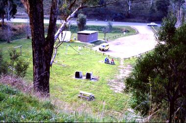
Slide - Photograph, John Ramsdale, Car park on Kurrak Road Yarrambat: Slide 45, 1990s
Photograph shows a park and carparking area with people sitting at picnic table, Middle Gorge Park, Yarrambat.Part of the John Ramsdale collection of slides and audio visual material.Colour photograph scanned from slide.No maker's marks. No caption on slide.middle gorge park, yarrambat, kurrak road yarrambat -
 Greensborough Historical Society
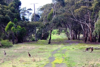
Photograph - Digital image, Marilyn Smith, Blue Lake: Kangaroos at Yellow Gum Park, 19/06/2015
Blue Lake is in Yellow Gum Park in the Plenty Gorge, north of Greensborough. These photos show kangaroos in the Park.Digital copy of colour photographsyellow gum park, blue lake, plenty gorge park -
 Stawell Historical Society Inc
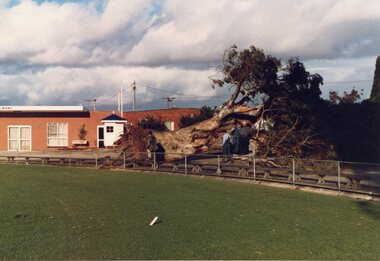
Photograph, Large Redgum Corroboree Tree --- Fallen down at Central Park with Athletic Clubrooms in the background -- 2 Photos -- 1 Coloured
Corroboree Tree – Central Park with Athletic Clubrooms at Central Park. Small white ticket box beside itstawell -
Glen Eira Historical Society
Article - Princes Park
This file contains four items. Princes Park information kit (misspelled princess park) compilation (clipped together) of photocopied material about aspects of the park, beginning with Princes Park North East Ground, official report for Glen Eira Council on condition of the park and recommendations for improvements, with blueprints and maps of proposed development. No date but most recent dated page (two letters from Douglas R Aylen, Chief Executive Officer, City of Caulfield, to residents about Princes Park playground is dated 20/05/1991. Includes photocopies of official materials on the purchase of land for the Park beginning in 1920. About sixty pages in all of which several relate to Caulfield Football Club and its campaign for a new pavilion 1967-70. Community News featuring Caulfields Parks and Gardens cutting from Caulfield Contact, 12/1991, on improvements to the park. Photocopy of letter from Rohan Storey Campaigns Coordinator, National Trust of Australia, Victoria to Manager, Planning Section, Glen Eira Council, dated 13/09/2002, headed National Trust Classification of Tree at Princes Park, South Caulfield Quercus suber (cork oak) at Regional level. Includes attached assessment form. Two black and white photocopies of photographs of Princes Park undated from Glen Eira Library Princes Park file, handwritten verso.princes park, parks and resources, glen eira city council, wilson k.d, harris mr, bricker d.c, caulfield football club, victorian football association, princes park trust, evans tim, ladson w.t, dixon r.c, caulfield church of christ, lewis mrs. i.e, caulfield south bowling club, hawkins a.w, briggs j.a, mcdonald s.l, renouf l.s, patience geoff, little ajax football club, gardenvale football club, south east suburban football club, southern metropolitan police football club, caulfield city soccer club, christian brother old boys, caulfield bears cricket club, national trust of australia (victoria), cork oak, tree, storey rohan -
 Kew Historical Society Inc
Photograph - Second Johnston Street Bridge in Flood, 1934
Original, small black and white print photograph of crowds lining the Johnston Street Bridge watching the flood waters below. The annotation on the reverse clarifies that Kew is in the distance.Annotated on reverse: "Gift of G.S. Beard / 2nd bridge / Johnston St. Studly Park Rd. Bridge looking towards Kew / 1st bridge 1858–1876, 2nd bridge built (bad bend), 1876–1958, 3rd bridge 1958, lined up Johnston St and Studley Park Rd."johnston street bridge, bridges - yarra river -- kew (vic.), flood -- 1934 -
 Ringwood and District Historical Society
Document - Subdivision Map, Part of Crown Sections 18, 19, 24 & 25, Parish of Warrandyte, County of Evelyn, Vol 5228 Fol 472 - 1926. (Park Orchards, Victoria)
A3 and A4 sized photocopies showing map section of land title showing streets, easements and allotment numbers, some with handwritten names and pricing notations circa mid 1950s.Map includes Valley Road, Granard Avenue, Park Road, Arundel Avenue, Hylton Avenue, Aviemore Avenue, Bowmore Avenue, Hopetoun Road, Colin Avenue, Daintree Avenue, Brucedale Crescent, Feversham Avenue, Ennismore Crescent, Iona Grove, Elgin Crescent and Gosford Crescent, Park Orchards, Victoria. -
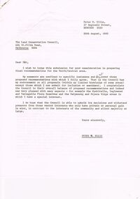 Bendigo Historical Society Inc.
Document - PETER ELLIS COLLECTION: LETTER, 20th August, 1980
Letter (11 Pages) from Peter N Ellis to the Land Conservation Council. Letter refers to proposed State parks - Kamarooka State Park and Whipstick State Park. other areas mentioned are the Wellsford Forest, Mandurang Forest, Lockwood Forest, Waanyaraa, Fryerstown, Whipstick Hill (Flagstaff Hill) and Black Rock. Other areas are Wellsford/Axedale Forest, Sugarloaf Range, Mandurang Forest, Main Coliban Channel, Lockwood Forest, Tarnagulla/Dunolly Forest, Fryerstown, Seven Sisters (between Huntly and Goornong). Plant and tree life in each area is mentioned including the cutting of eucalypt for the production of Eucalyptus oil.person, individual, peter ellis oam, peter ellis collection, land conservation council, kamarooka state park, whipstick state park, eucalyptus oil production, fncv victorian naturalist, d j paton, bendigo field naturalists club, wellsford forest, mandurang forest, main coliban channel, lockwood forest, waanyaras, fryerstown, whipstick hill (flagstaff hill), parish of neilborough, old underground water race, puddling machine, srwsc -
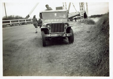 Phillip Island and District Historical Society Inc.
Photograph, Jim Nilsson & friends at Continental Guest House, Xmas 1946-47 and 1949, 1946,1947,1949
Photos taken on a trip or trips to Phillip Island in the 1940s by Jim Nilsson and friends. . There were other people called ? Taylor and Neil mentioned on rear of photos. A negative of the bridge was also donated.Historical4 small black & white photos . First shows a jeep parked at the San Remo side of the bridge, second is taken driving across the bridge towards the island. Third is the Continental guesthouse with 4 cars parked at the front and women walking along footpath.The last photo is a group of 4 young men, arms around their shoulders, standing in front of the Continental- one is Jim Nilsson.first phillip island bridge to san remo, continental guest house,, jim nilsson, bridges -
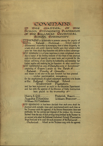 Federation University Historical Collection
Certificate, Ballarat Technical School Endowment Plantation, 1928, 1928
The School Endowment Plantation Scheme was established in 1922 as a joint venture between the Education Department and the FCV. It was administered by the Education Department with technical supervision by the Commission. While some plantations were established on private land donated or leased for the purpose, most were established on Crown Lands or Reserved Forest made available, without cost, by the State. (https://www.victoriasforestryheritage.org.au/community/schools.html, accessed 26 September 2020) Throughout the Nerrina district numerous areas of public land were set aside as school endowment plantations as part of various schools’ educational resources. The plantations were initially established to instil through community involvement a love of forests and an appreciation of their value, and in fact many of them are well suited for regular use as a teaching resource of this nature. It was expected that this use will increase as courses embracing various aspects of environmental science are developed. Many school plantations have been planted to radiata pine, and revenue from the sale of produce used to provide amenities required by the schools. In some cases, however, these plantations have not been very successful in providing revenue, as the sites are unsuitable for economic growth or the plantations are too small or the location too far from processing centres to allow economic harvesting. In some instances, radiata pine plantations have failed due to poor management. In 1982 the Land Conservation Council believed that all the existing plantations should be assessed in order to establish their value as a teaching resource. Those not needed or that are unsuitable for teaching purposes for some reason, such as their location, should be terminated. Those planted to radiata pine that have limited value as a teaching resource although satisfactory for wood production may continue to be used for such production, but should be reviewed when the pines are harvested. (http://www.veac.vic.gov.au/reports/354-Ballarat-Study-Area.pdf, acccessed 30/03/2017) Three A3 page covenant outlining the 35 acres of Crown Land in the Parish Of Ballarat, County of Grenville, to be granted under permissive occupancy for the establishment of a school plantation to be known as the Ballarat Technical School Endowment Plantation, and two letters relating to same, one on green paper. The Ballarat Technical School Endowment Plantation was at Vale Park, Ballarat. Vale Park is near Norman Street, Ballarat. pine plantation, ballarat junior technical school, alumni, ballarat technical school, ballarat technical school endowment plantation, harry s. gill, augustine f. hesiltine, william h. middleton, frederick brawn, william brazenor, a.w. steane, j.b. robinson, vale park, lindsay hillman, a.j. sutherland, oliver r. roberts, w.a. richardson, w.i. watson, j.g. hopwood, g.f. rumpff, e.j. dalker, john b. colbourn, jack r. collins -
 Bendigo Historical Society Inc.
Photograph - RED RIBBON COLLECTION: PHOTOGRAPHS RED RIBBON AGITATION RE-ENACTMENT
Sixteen colour photographs of Red Ribbon Re-enactment performed by members of the Bendigo Historical Society and students from Bendigo schools. Re-enactment started in Rosalind Park, near plaque commemorating the movement and proceeded through the Park to a point outside the Bendigo Art Gallery. Photos show various stages of the re-enactment and participants including Jim Evans, Norm Harris, Phyllis Harris.bendigo, history, red ribbon agitation -
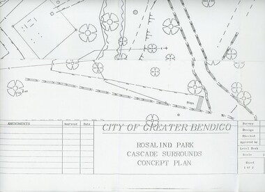 Bendigo Historical Society Inc.
Plan - MERLE HALL COLLECTION: ROSALIND PARK CREATIVE VILLAGE BENDIGO PROJECT CONCEPT PLAN, 1993
MERLE HALL COLLECTION: ROSALIND PARK CREATIVE VILLAGE BENDIGO PROJECT Concept Plan City of Greater Bendigo Rosalind Park Cascade Surrounds Concept Plan number GB095 Sheet 1 of 2 Level Book 365, Backup No Tape 01, Computer File No. ROS QEO. Large Sheet which shows the location of utilities, vegetation, drains, embankments etc. June 1993 -
Kew Historical Society Inc
Archive (Sub-series) - Subject File, Bowling Clubs, 1958
Various partiesReference, Research, InformationKHS OrderSubject file containing correspondence relating to the former Studley Park Bowling Club in Barry Street, Kew and its relocation to Yarra Bend Park. The file includes a photocopy of the letter by Nigel Lewis to the City of Kew, describing the historic importance of the Club (established c.1903) and the necessity of moving it before demolition. The file has information relating to the pavilion’s move and restoration as an art centre. [ KHS also holds the complete archives of the Auburn Heights Recreation Club (1904-98), the Kew Bowling Club (1880-1998) and the Kew Heights Sports Club (1998-2012). These are separate archives in Provenance Order].sports clubs - kew (vic.), studley park bowling club, urban conservation, heritage protectionsports clubs - kew (vic.), studley park bowling club, urban conservation, heritage protection -
 Kew Historical Society Inc
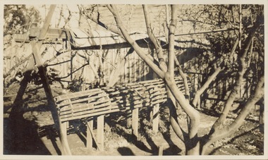
Photograph - Victorian Canoe Club, Mould for racer, 1920-30
Canoeing on the River Yarra at Melbourne was an important and widespread recreational pursuit for Melbournians, especially in the first half of the twentieth century. The Victorian Canoe Club was formed in 1912 at a meeting in Melbourne and its first committee elected in the same year. Records indicate that the Club continued into at least the 1950s .The album has historic and social significance as a record of recreational activities (as well as canoe making) in the early years of the twentieth century. It has local significance as the site of the headquarters of the Club was in Studley park. A number of photographs in the album provide vistas of Kew on the Yarra that are otherwise unavailable.One of 24 labelled photos in part album, originating from the Victorian Canoe Club, which had its headquarters in Studley Park, Kew. The album includes a photographic record of canoe construction and also locations in Studley Park and Kew where the canoes were used. The subject of this photograph is identified as 'Mould for racer' which was set up in a backyard to form the frame for manufacturing a racing canoe."Mould for racer"victorian canoe club, canoe making, canoe construction, canoe moulds -
 Kew Historical Society Inc
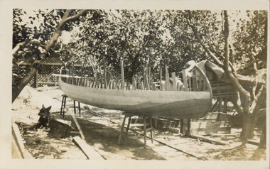
Photograph - Victorian Canoe Club, Off mould, 1920-30
Canoeing on the River Yarra at Melbourne was an important and widespread recreational pursuit for Melbournians, especially in the first half of the twentieth century. The Victorian Canoe Club was formed in 1912 at a meeting in Melbourne and its first committee elected in the same year. Records indicate that the Club continued into at least the 1950s .The album has historic and social significance as a record of recreational activities (as well as canoe making) in the early years of the twentieth century. It has local significance as the site of the headquarters of the Club was in Studley park. A number of photographs in the album provide vistas of Kew on the Yarra that are otherwise unavailable.One of 24 labelled photos in part album, originating from the Victorian Canoe Club, which had its headquarters in Studley Park, Kew. The album includes a photographic record of canoe construction and also locations in Studley Park and Kew where the canoes were used. The subject of this photograph is identified as 'Off mould' where, following the completion of the hull, the boat is 'righted' to allow for the finishing of the canoe.."Off mould"victorian canoe club, canoe making, river yarra, burke road, mornington, studley park, kew, steaming gear, canoe construction -
 Kew Historical Society Inc
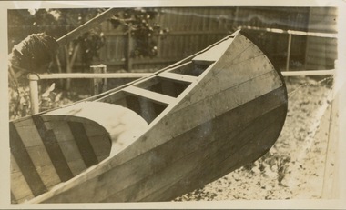
Photograph - Victorian Canoe Club, Built-up ends & deck frames, 1920-30
Canoeing on the River Yarra at Melbourne was an important and widespread recreational pursuit for Melbournians, especially in the first half of the twentieth century. The Victorian Canoe Club was formed in 1912 at a meeting in Melbourne and its first committee elected in the same year. Records indicate that the Club continued into at least the 1950s .The album has historic and social significance as a record of recreational activities (as well as canoe making) in the early years of the twentieth century. It has local significance as the site of the headquarters of the Club was in Studley park. A number of photographs in the album provide vistas of Kew on the Yarra that are otherwise unavailable.One of 24 labelled photos in part album, originating from the Victorian Canoe Club, which had its headquarters in Studley Park, Kew. The album includes a photographic record of canoe construction and also locations in Studley Park and Kew where the canoes were used. The subject of this photograph is identified as 'Built-up ends & deck frames' where the canoe its completed and ready for testing."Built-up ends & deck frames"victorian canoe club, canoe making, river yarra, burke road, mornington, studley park, kew, steaming gear, canoe construction -
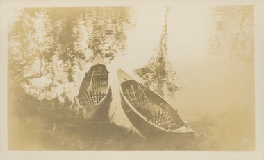 Kew Historical Society Inc
Photograph - Victorian Canoe Club, Nagha & Dunapna completed completed, 1920-30
Canoeing on the River Yarra at Melbourne was an important and widespread recreational pursuit for Melbournians, especially in the first half of the twentieth century. The Victorian Canoe Club was formed in 1912 at a meeting in Melbourne and its first committee elected in the same year. Records indicate that the Club continued into at least the 1950s .The album has historic and social significance as a record of recreational activities (as well as canoe making) in the early years of the twentieth century. It has local significance as the site of the headquarters of the Club was in Studley park. A number of photographs in the album provide vistas of Kew on the Yarra that are otherwise unavailable.One of 24 labelled photos in part album, originating from the Victorian Canoe Club, which had its headquarters in Studley Park, Kew. The album includes a photographic record of canoe construction and also locations in Studley Park and Kew where the canoes were used. The subject of this photograph is identified as 'Nagha & Dunapna completed' with an overhead view of two named canoes on the banks of the Yarra River."Nagha & Dunapna completed"victorian canoe club, canoe making, river yarra, burke road, mornington, studley park, kew, steaming gear, canoe construction