Showing 3442 items
matching agriculture.
-
 Phillip Island and District Historical Society Inc.
Photograph, 1960's
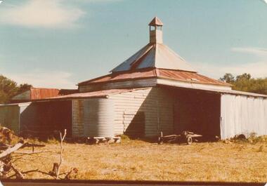
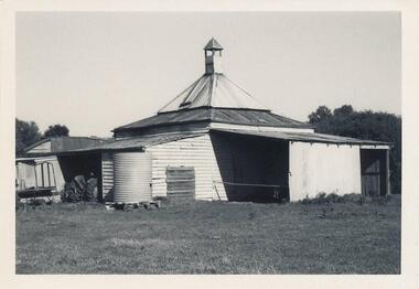
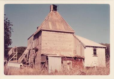
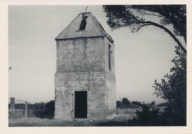
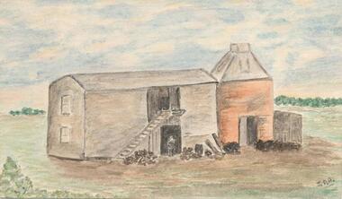
Donated by N. M. & J. D. Archibald. April, 1973Colour Photograph. Chicory Kiln. Cowes. Mr. E. C. Wood, Settlement Road, East. Built of mud 18" thick about 1880 by J. Jenner. Oldest Kiln in operation as at 1973. Chicory Kiln Albumlocal history, photography, photographs, agriculture buildings, historic, chicory kiln, cowes, phillip island, e c wood, j jenner, n & j archibald -
 Phillip Island and District Historical Society Inc.
Photograph, 1960's
Donated by N. M. & J. D. Archibald. April, 1973Black & White Photograph. Chicory Kiln. Cowes - Mr. E. C. Wood, Settlement Road East. Built of mud 18" thick about 1880, by J. Jenner. Oldest Kiln still in operation as at April 1973. Chicory Kiln Album.local history, photography, photographs, agriculture buildings, historic, chicory kiln, cowes, phillip island, e c wood, j jenner, n & j archibald -
 Phillip Island and District Historical Society Inc.
Photograph, 1960's
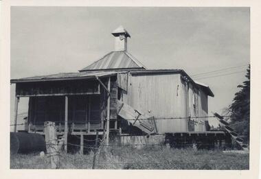
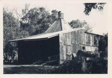
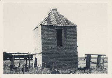
Donated by N. M. & J. D. Archibald. April, 1973Black & White Photograph. Chicory Kiln. Ventnor - Mr. J. Hobbs. Still in operation (1973) converted to oil. Built by Cyril Clarke about 1930. Iron & Wood structure. Chicory Kiln Album.local history, photography, photographs, agriculture buildings, historic, chicory kiln, ventnor, phillip island, j hobbs, cyril clarke, n & j archibald -
 Phillip Island and District Historical Society Inc.
Photograph, 1960's
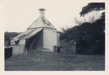
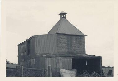
Donated by N. M. & J. D. Archibald in April 1973Black & White Photograph. Chicory Kiln. Ventnor - W. Guyatt. Built by T. Jones. Brick & Iron. Chicory Kiln Album.local history, photography, photographs, agriculture buildings, historic, chicory kiln, black & white photo print, ventnor, phillip island, w guyatt, t jones, n & j archibald -
 Phillip Island and District Historical Society Inc.
Photograph, 1960's
Donated by N. M. & J. D. Archibald. April 1973Colour Photograph. Chicory Kiln. Ventnor - Mr. K. McKindlay. Concrete with Iron & Fibro structure. Built approximately 1940. Chicory Kiln Album.local history, photography, photographs, agriculture buildings, historic, chicory kiln, colour print, ventnor, phillip island, k mckindlay, n & j archibald -
 Phillip Island and District Historical Society Inc.
Photograph, 1960's
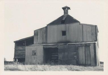
Donated by N. M. & J. D. Archibald. April 1973Black & White Photograph. Chicory Kiln. Rhyll - Mr. P. Forrest, Snr. Poured cement with wooden structure at front. Mr. Bob Jeffery & Mr. Alex Jenner helped in building in 1944. Operated up to about 1962. Elevator sold to Mr. John Neely and later to Mr. Bert Grayden. Chicory Kiln Album.local history, photography, photographs, agriculture buildings, historic, chicory kiln, rhyll, phillip island, p forrest snr, bob jeffery, alex jenner, john neely, bert grayden, n & j archibald -
 Phillip Island and District Historical Society Inc.
Photograph, 1960's
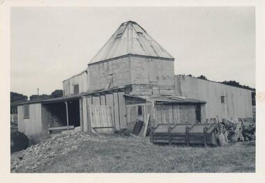
Donated by N. M. & J. D. Archibald. April 1973Black & White Photograph. Chicory Kiln. Cowes - Mr. P. Forrest, Jnr. Brick with Iron structure in parts. The Kiln was used for processing for other people. Built by Mr. H. Bennell about 1912. Chicory Kiln Album.local history, photography, photographs, agriculture buildings, historic, chicory kiln, cowes, phillip island, p forrest jnr, h bennell, n & j archibald -
 Phillip Island and District Historical Society Inc.
Photograph, 1960's
Donated by N. M. & J. D. Archibald. April 1973Black & White Photograph. Chicory Kiln. Cowes, Main Road - Mr. G. Stoppa. Cement blocks with Iron, Wood & Fibro. Built late 1940's or 50's. Chicory Kiln Album.local history, photography, photographs, agriculture buildings, historic, chicory kiln, cowes, phillip island, g stoppa, n & j archibald -
 Phillip Island and District Historical Society Inc.
Photograph, 1960's
Donated by N. M. & J. D. Archibald. April, 1973.Black & White Photograph. Chicory Kiln, Newhaven - Main Road. Remains of brick & concrete Kiln, with very old pear tree nearby. Built by Mr. Bern Denham as a young man in the 1920s (J. Box, personal communication). Chicory Kiln Album.local history, photography, photographs, agriculture buildings, historic, chicory kiln, newhaven, phillip island, n & j archibald, b denham -
 Phillip Island and District Historical Society Inc.
Photograph, 1960's
Donated by N. M. & J. D. Archibald, April 1973.Black & White Photograph. Chicory Kiln - Ventnor - Mr. Justice. Brick & Wooden remains. Chicory Kiln Album.local history, photography, photographs, agriculture buildings, historic, chicory kiln, ventnor, phillip island, mr justice, n & j archibald -
 Phillip Island and District Historical Society Inc.
Photograph, 1960's
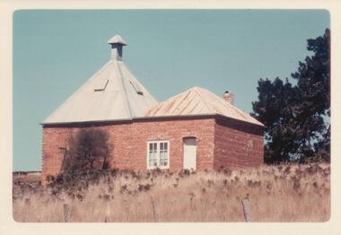
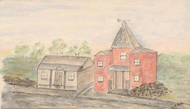
Donated by N. M. & J. D. Archibald, April 1973.Colour Photograph. Ventnor. Hurricane Hill (Richardson's Hill). Built about 1883. 18' x 18'. Brick double one story. Originally built for Mr. T. Richardson. Now being used as a holiday house (1973). Chicory Kiln Album.local history, photography, photographs, agriculture buildings, historic, chicory kiln, hurrican hill, home, richardson, ventnor, n & j archibald, richardson's hill ventnor phillip island -
 Phillip Island and District Historical Society Inc.
Photograph, 1960's
Donated by N. M. & J. D. Archibald. April, 1973Black & White Photograph. Cowes, Thompson Avenue. Mr. N. Cleeland. Mud with iron & wood outer structure.local history, photography, photographs, agriculture buildings, historic, chicory kiln, n cleeland, jimmy roberts, n & j archibald -
 Phillip Island and District Historical Society Inc.
Water Colour Sketch, 1960's
Donated by N. M. & J. D. Archibald. April, 1973.Colour 18.5 Sketch done from old photograph. Chicory Kiln - Jansson Family, approximately 1880's. It was built on the land next to the Caravan Park. The only remains of it now are a few bricks on the site. The sketch shows Mr Frank Jansson as a young boy in the doorway. Galvanized iron structure was sold to Mr N Cleeland.local history, illustrations, agriculture buildings, historic, chicory kiln, water colour sketch, jansson family, n & j archibald, jean archibald -
 Phillip Island and District Historical Society Inc.
Water colour Sketch, 1960's
The first kiln built on Phillip Island in the 1870's for Mr John West. It was situated in Thompson Avenue next to Wests General Store. When the kiln was demolished, the bricks were used to build the old Post Office on the corner of the Esplanade. Mr John West gave a Banquet at the Isle of Wight Hotel to celebrate the opening of his kiln.Water Colour Sketch. This picture was reconstructed by Jean Archibald from pencil sketches by S Serpell in 1905, and an artist who travelled to Phillip Island with the "Vagabond", a journalist for the "Leader", in 1889. Chicory Kiln built for John West situated in Main Street, Cowes. First Chicory Kiln built on Phillip Island in the 1870's.Signed J. D. A.local history, illustrations, agriculture buildings, historic, chicory kiln, water colour sketch, west family, post office cowes phillip island, jean archibald, s serpell, john west, n & j archibald -
 Phillip Island and District Historical Society Inc.
Photograph, 1960's
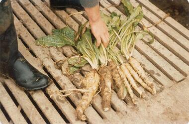
Donated by N. M. & J. D. Archibald. April, 1973.Photograph of Chicory roots. Part of boot and hand showing - on board floor.local history, photography, photographs, agriculture buildings, historic, chicory kiln, a. mcfee jnr, n & j archibald, chicory leaf, chicory root, chicory -
 Phillip Island and District Historical Society Inc.
Dried Chicory, 1973
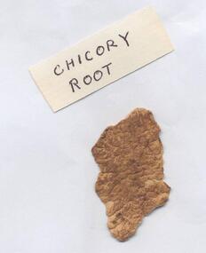
Dried Chicory Root dried in McFee's Kiln and grown on property.Dried Chicory Root grown on McFee's property, Rhyll, dried in McFee's Kiln.local history, rural industry, agriculture, chicory industry, chicory, phillip island, mcfee, n & j archibald, chicory root -
 Phillip Island and District Historical Society Inc.
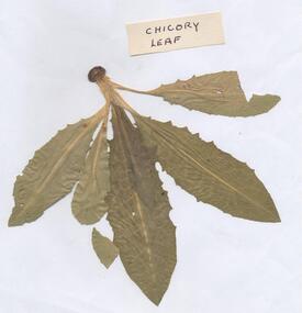
Dried Chicory Leaf, Unknown
Leaf of Chicory - from crop, only the root is used. Leaves are cut off with knife or twisted off by hand. Part of a collection of Chicory Kiln Photographs and Chicory Items compiled into an Album by N.m. & J. D. Archibald.Dried Chicory Leaf taken from McFee's crop of Chicory grown on property at Rhyll. Chicory Kiln Albumlocal history, rural industry, agriculture, chicory industry, chocory leaf, phillip island, n & j archibald, mcfee -
 Phillip Island and District Historical Society Inc.
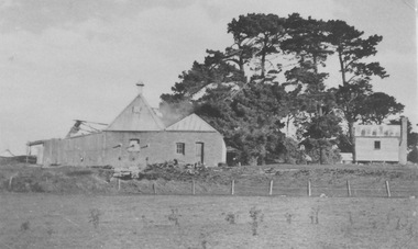
Photograph, Chickory kiln Ventnor
Part of a collection of 'Rose & Valentine' series of Post Cards. Copied by John Jansson 1984B&W postcard. View of chicory Kiln and small house - VentnorNone on Photograph. Underneath added Chicory Kiln - Ventnorlocal history, photography, photographs, postcards, agriculture, buildings, farming - agriculture, black & white postcard copy, chicory kiln, ventnor, phillip island -
 Greensborough Historical Society
Folder, Aerial Imaging - Plenty River: by Ian Bryant, 2011_11
Investigates early land use along the Plenty River from north of the main aqueduct crossing in Greensborough to south of the golf course in Lower PlentyHistorical features seen from aerial and satellite images of the modern landscape may indicate earlier agricultural land usage.9 x A4 pages of text and colour annotated maps downloaded from nearmap.com.plenty river, ian bryant, lower plenty, greensborough, yallambie park, aerial photography -
 Glenelg Shire Council Cultural Collection
Booklet, H. Hearne & Co. Paragon Printers. 208/210 Little Lonsdale St. Melbourne, Royal Agricultural Society of Victoria, 1905
Cream soft cardboard cover. Orange, black printing on cover. Black printing on spine. Catalogue of Exhibits.agriculture, show, society, advertising -
![Sculpture - Bas-relief, Untitled [Early Agricultural Industries], n.d](/media/collectors/4f729f5597f83e03086015b1/items/655a82f77f3f3810362edbc4/item-media/655a83c17f3f3810362ef7db/item-fit-380x285.jpg) Glenelg Shire Council Cultural Collection
Glenelg Shire Council Cultural CollectionSculpture - Bas-relief, Untitled [Early Agricultural Industries], n.d
Commissioned by State Bank to produce 5 copper bas-reliefs for 73 Percy Street, Portland. Spoke with Miss Betty Vivian (Member of the Portland Historical Society) re Portland's history. Commonwealth Bank stored objects in Melbourne (c.1991). Negotiations between Portland Historical Society and Commonwealth Bank of Australia led to gift of works to People of Portland. Stored at Council depot c.1998, retrieved for Maritime Discovery Centre display.Copper bas-relief depicting two horses pulling a plow, which a man is walking behind and guiding. Three birds are flying close to the ground in the foreground, and there is a stylized sunburst (a partial circular form with radiating lines) depicted in the background. More abbreviated bird forms are depicted against the sun and sky.sculpture, bas-relief, copper -
Glenelg Shire Council Cultural Collection
Photograph - Photograph - Heywood Show, n.d
Black and white photo of the Heywood Show at the Heywood Reserve.Back: 'Heywood Show' - handwritten in pencilheywood, glenelg shire, heywood show, rural show, agricultural show -
Glenelg Shire Council Cultural Collection
Photograph - Photograph - Heywood Show, n.d
Black and white photo of the Heywood Show at the Heywood ReserveFront: 'Heywood Show' - handwritten, pencilrural show, agricultural show, heywood -
Glenelg Shire Council Cultural Collection
Negative - Glass Plate Negative - Portland Show, 1890-1910
Glass plate negative. Crowd at Portland Show, watching horse events. Blur above the fence is a jumping horse.Front: 'Portland Show'glass plate negative, portland show, agriculture, recreation, show jumping, sport -
 Kiewa Valley Historical Society
Photograph of Kiewa Valley Panorama, Farming lands within the Kiewa Valley in1950s, Circa 1950
This photograph shows how (early to mid1900s), before the establishment of the Mount Beauty "gated" village, the Kiewa Valley was farmed and the scarce population was spread out over acres of productive land. This photograph catches a time before (what appeared to the local farmers as the invasion by a mass of construction workers) when this remote valley was part of a "lay back" rural landscape,occasionally visited by friends and some wayward tourists. The mountain ranges provided an adequate barrier against the way-would traveller. The immigration numbers coming into Australia was still quite small ( due to the "white" Australia policy) which was in force before World War II. After World War II a mass of displaced European refugees and migrants boosted the Australian population and provided for a greater degree of diverse professions and rural related work force.This photograph depicts the borderline in time between an exclusively rural based population and respective activities(early 1900s)to the present (2000 on wards) integrated village, tourist and retiree/holiday area. The time when land was exclusively used in agriculture is over and the impact of cheaper rural produce from Asian markets will see a shift of land useage and population activities. The Kiewa Valley is loosing its hiding place and is becoming more and more a source of untapped residential land. Black and white photograph of farming/grazing land useage, before the establishment of the Mount Beauty Village. Small pockets of residentual houses can be viewed. Road access (unsealed dirt) was typical of that provided in rural regions in the 1950s. The photo is on 200gms paper and not on photographic paper.kiewa valley in the early1900s, grazing in the kiewa valley, sec victoria -
 Kiewa Valley Historical Society
Photograph of Snow Covered Catchment Area Vic, Snow Covered Catchment Area Victorian Alps - 1950s, Circa 1950
This photograph details (early to mid1950s), the Victorian Alpine region when this remote area was part of a "lay back" rural landscape,occasionally visited by recreational adventurers and some wayward tourists. The mountain ranges had provided an adequate barrier against the way-would traveller, but with the opening up of this region by the provision of improved roadways and accommodation facilities, courtesy of the Kiewa Valley Hydro Electricity Scheme, changes such as tourism and its impact upon the "natural" state started to show its side effects (clearing of the land). The expansion of the European immigration numbers (1950s) coming into Australia was increasing after World War II which not only provided increased construction workers to the region but also immigrants who appreciated alpine regions. Some of these immigrants contributed to the expansion of the region and provided for a greater degree of diverse professions and rural related work force.This photograph depicts the borderline in time between an exclusively rural based population and respective activities(early 1900s)to the present (2000 on wards) integrated village, tourist and retiree/holiday area. The time when land was exclusively used in agriculture and Alpine grazing lands is over. The Kiewa Valley is loosing its hiding place and is becoming more and more a source of untapped residential land and winter time recreational adventure lands. The changes brought about by modern technologies involving recreational activities such as hang gliding, gliding (local airstrip), mountain bikes, car rallies and their associated clubs is providing for an increased short term population boost. These together with the attractions for retirees is changing not only the physical nature of the Kiewa valley but also its "soul".This item is a black and white photograph of a section of snow covered catchment area in the Victorian Alps in the mid 1900. It is on 200 gms paper but not on photographic paper and has a white boarder (3 mm).kiewa valley tourism, victorian alps, alternate energy supplies, alpine population growth -
 Kiewa Valley Historical Society
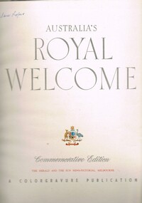
Book - Non Fiction History, Australia's Royal Welcome 1954, circa 1954
This publication covers the mid 1900s and relates to a period where the majority of the Australian population was engrossed with the Queen of Australia, even though her Highness did not reside on this continent. The period covered was before the great immigration insurgence from Europe.The Labour Party's "White Australian" policy was a hinderance and a barrier towards the Asian and African prospective immigrants. The motto Queen and Country was still very ingrained in the rural population. This period in Australian domestic self reliance, brought about the growing strength and very active trade union movement and their staunch support for the Tariff protection against a growing swell of imported goods. This self reliance psyche was essentially a by product of World War II, and the isolation felt by the Australian People. The Queen (royalty) was the binding force holding the British Empire together which was emphasised with her popularity when touring Australia Queen Elizabeth's visited the MCG twice in 1954 1. to attend an assembly of ex-servicemen and women's organisations 2. to attend a Children's Display. She also visited Government House and visited Country Victoria on the Royal train from 24th Feb - 9th March.The Kiewa Valley and all the rural areas in the region were still very much tied to the "mother land" and trade between Britain and Australia was very strong. Trade with Asian manufacturers was minimal and needed the late 1900s to see both the trade and immigration barriers fall. This book was produced during a time when the majority of Australians looked more to England for trade and companionship. The agricultural trade with England and Europe was very high and the motto of the time was "Australia grows on the sheep's back". Late 1900's saw the motto "Australia grows on the miner's back" The Queen was still very popular then which was emphasised by the large crowds which greeted her on tour. Residents of Mt Beauty including Cubs, Brownies, Scouts and Guides travelled to Benalla to see the Queen. Clare Roper was a founding member of the KVHS and attended a garden party at Buckingham Palace representing the local CWA. She has purchased this book and therefore giving this a close historical significance connection, it has good provenance and interpretive capacity. This hard(blue coloured) covered book contains thirty six double sided pages. Both the first and last pages (inside cover included) has the royal crest of Australia (kangaroo and emu) balancing the individual six states crests ,united under the royal crown. The first six double pages, each portraying a coloured free hand sketches of various Australian scenery enclosing the Queen's day by day and State by State itinerary. There are 115 black and white photographs and 25 coloured photographs contained in this book.Third page has free hand penned signature "Clare Roper"1954 royal tour, queen elizabeth ii monarchy, british empire in the 1900s, god save the queen. -
 Kiewa Valley Historical Society
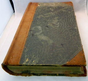
Book - Ledger Commercial, unknown, Circa 1920
Historically(1920 to 1927), this ledger not only details the legible hand writing of this era but also the day to day commercial activity in the Kiewa Valley region. The neatness and the diligence of those who were required to pen the information into this ledger was a requirement by all who were involved in commercial trade be it in the city or in the rural area. Emphasis on neatness was ingrained in students at a young age. This era was well before general commercial stock computer based inventories. Generally all students of commerce required an accuracy in writing and arithmetic. Neatness and order were a "selection criteria" requirementThis item clearly identifies the Kiewa Valley as having a substantial financial hub to accommodate the various commercial enterprises within a rural environment Circa 1880's. Although Kiewa Valley had mining, agriculture, cattle and sheep it was also composed of a mixed society, encompassing all levels of society at that period. It identifies some the commercial activities(newsagency) undertaken by specific families farming in the Kiewa Valley and relates their history in the period of 1920 to 1927This ledger has a very thick cover of strong compressed cardboard. It has a cloth covering (Glued on) and is a faded blue colour. The corners of the opening side of the cover are reinforced by suede cloth,in a triangular shape, and enclose both the front and inside portions of the the ledger. The spin is reinforced by a suede section to provide increased strength and protection. The inside cover (both front and back) has an orange and brown bubbles and specks pattern. The grammage of the lined sheets (blue) is approximately 120g/m. The first twelve pages are indented and alphabetically marked with alternating red and black letters (two letters per page except for the last page which has three letters). The remaining pages are numbered in black print at the top outside edge of each page. There are 742 page numbers. Each page has thirty two blue horizontal lines and one double red line (second from top) Each page has thirteen vertical lines starting from the top horizontal double red lines and ending at the bottom of the page. These lines segregate the page into blocks for the date, the transaction and financial input. There are three double vertical red lines which designate the amount of money of each transaction (in pounds shillings,and pence).Located on the top section of the spin (in gold print on red background) "LEDGER" This is framed within a golden printed pattern of straight and squiggly lines.ledger, book keeping, 1920s commercial transactions, local kiewa valley commercial history -
 Kiewa Valley Historical Society
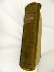
Book - Ledger Commercial, "Ledger No. 4", Circa 1895
Historically this ledger not only details the legible hand writing of this era but also the day to day commercial activity in this region(first entry in 1895).The neatness and the diligence of those who were required to pen the information was a requirement by all who were in commercial trade. Emphasis on neatness was ingrained in students at a young age. This era was well before general typewriters and computers. Generally all students of commerce required an accuracy in writing and arithmetic. Neatness and order were a selection requirement. This ledger belonged to a general store, which was a forerunner to supermarkets and specialty stores. The shop provided everything from food, postage stamps, nails, tobacco, boots and Epsom salts. The general store provided nearly every product required to exist in a remote rural area of Australia in the 1800's.This item clearly identifies the Kiewa Valley as having a substantial financial hub to accommodate the various commercial enterprises within a rural environment Circa 1880's. Although Kiewa Valley had mining, agriculture, cattle and sheep it was also composed of a mixed society, encompassing all levels of society at that period. It identifies some the commercial activities(newsagency/general store) undertaken by specific families farming in the Kiewa Valley and relates their history in the pioneer period of the late 1800's. Some of those pioneers still have descendants living on the same home sites provided by the 1847 Land Act.This ledger has a very thick cover of strong compressed cardboard. Originally it had a cloth covering both front and back(Glued on) but due to wear and tear it is only attached to the back cover) and is a faded blue colour. The corners of the opening side of the cover are reinforced by suede cloth,in a triangular shape, and enclose both the front and inside portions of the the ledger. The spine is reinforced by a suede section to provide increased strength and protection. The inside cover (both front and back) has an orange bubbles with red and blue sinuous lines forming shapes in a haphazardous pattern. The grammage of the lined sheets (blue) is approximately 120g/m. Originally the first seven of twelve pages were indented and alphabetically marked with black letters (one letter per page) however this ledger had been modified to cover only the initials of customers and the pages of unused letters were glued to the previous page. The remaining pages are numbered in black print at the top outside edge of each page. There are 890 page numbers. Each page has thirty seven blue horizontal lines and one double red line ( top). Each page has thirteen vertical lines starting from the top horizontal double red lines and ending at the bottom of the page. These lines segregate the page into blocks for the date, the transaction and financial input. There are three double vertical red lines which designate the amount of money of each transaction (in pounds, shillings,and pence).On the suede spine in gold lettering and on a red (port coloured) background "LEDGER"grocery shop, haberdashery, general store -
 Kiewa Valley Historical Society
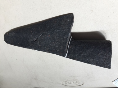
Ploughshare
The ploughshare cuts grass and soil loosening or turning the soil before sowing seed or planting. Ploughs were drawn by oxen and horses. Now drawn by tractors.Farmers in the Kiewa Valley used ploughs before tractors became available.Formerly KV 060. Made of steel and a component of a plough. It is the cutting or leading edge of a mouldboard which closely follows the coulter wen ploughing. Attached picture shows the ploughshare as part of a plough. Ref. Farmyard Relics by Ken Arnold Page 49ploughshare, agriculture, farming crops