Showing 4801 items
matching crown
-
 City of Moorabbin Historical Society (Operating the Box Cottage Museum)
Document, laminated List of Pioneers Moorabbin Parish, c1985
This list shows the names of the Pioneer settlers with the amount of Acres, the date purchased from The Crown and the Lot or Portion Number in the Land of the Henry Dendy Special Survey of Brighton 1841, in the County of Bourke , Victoria. The Squatters ,who arrived in the area first, used the land for grazing sheep and cattle. The Squatters had the right to graze unoccupied Crown land for ₤10 per year rental and a per capita payment for animals grazed. They could develop , improve and clear the land for the purpose of the tenancy but ownership was not permitted. When the land became useful The Crown put it on the market and the developers took over whilst the Squatters lost the improved land, dwellings and out buildings, there being no compensation paid. Squatters named John and Thomas Martin 1840-41; Richard and John King 1840- 1854 ; M.N.M.Moysey and M.J.Bickford 1841-1852 ; James McMahon 1846-1853 ; Daniel MacKinnon 1839- 1840. The 5120 Acres of the Henry Dendy Special Survey 1841were divided into approx. 83 Portions / Lots with varying acreage . Josiah Holloway, a speculator purchased 625 acres of the King Brothers run and re-sectioned the land into 2 acre Lots for Sale as market gardens. It was called The Two Acre Village later known as Cheltenham. A List of the names of The Pioneers in County of Burke Victoria c1841-1887 compiled by Lesley A. Schumer in 1985 A 3 Laminated display on wall in room 2 THE PIONEERS, Signed L.A. Schumer moorabbin, brighton, cheltenham, bentleigh, market gardeners, pioneers, early settlers, dendy henry, henry dendy's special survey 1841, squatters, king john, martin john, mcmahon james, two acre village, holloway josiah, were jonathan binn, grazing, cattle, sheep, market gardens, -
 Bendigo Military Museum
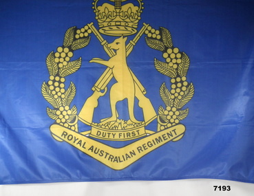
Banner - BANNER, 1RAR
1st Battalion RAR is a Motorised Battalion of the Australian Army, based out of Townsville. Banner donated by Shane Reynolds of 1 RAR A Coy. PT321635.Large banner, predominately dark blue, large gold and black emblem in centre. Emblem has standing Kangaroo in centre over two crossed rifles. A crown above the Kangaroo who is standing on a base with motto on the base. Below the base is a boomerang with Royal Australian Regiment inscribed. From the end of the boomerang, leaves and fruit of a plant curling up to the crown giving a rough circular configuration. In top left corner numeric of "1" in white. Top right corner a flag emblem in colours of green, blue and green. Left edge of banner has white reinforcement and small plastic hole at top and bottom.Inscribed on base " Duty First" as motto and " Royal Australian Regiment". 1 rar, banner -
 Bendigo Military Museum
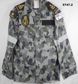
Uniform - UNIFORM, DISRUPTIVE PATTERN, NAVY, CTE Pty Ltd, 2010 - 2011
Naval Uniform - brand new. 1. Jacket - 75% cotton, 25% polyester fabric. Grey, dark grey and dark green disruptive pattern. Metal stud closures. Epaulettes - gold embroidered crown, crossed anchors and "AUSTRALIA" unit shoulder flashes - both embroidered with gold, white and red thread - R. three headed dog/ "HMAS CERBERUS" - ships badge. L. Australian Navy White Ensign. Chest patch - embroidered gold, red and white RAN Patch - Crown, Anchor and R.A.N. logo. 2. Trousers - 75% cotton, 25% polyester fabric, grey, dark grey and dark green disruptive pattern.Both - Maker's label - black print on white label "CTE PTY LTD/ JUNE 2010/2011" / "75% cotton 25% polyester/ FR treated". Then extensive information on laundering care of fabric. "MADE IN AUSTRALIA" .uniforms, dpnu, ran -
 Bendigo Military Museum
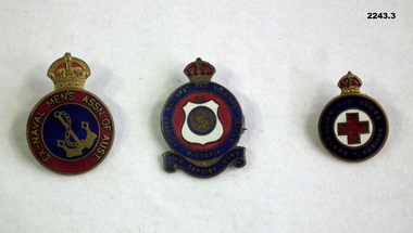
Accessory - BADGES, Post 1945 possible
.1) Badge, metal, round with crown on top centre in blue circle is a gold anchor and chain, around outside in red with gold lettering is "Ex Naval Mens Assn of Aust". rear has 2 lugs and is numbered stamped. .2) Badge, metal round with plaque on red back ground. Around outside on blue back ground and scroll "Returned Sailors and Soldiers League Victoria War Service Fund". Numbered badge. .3) Badge, metal round with crown at top. Red Cross in Centre surround by blue circle with "Australian Red Cross Society" Rear has pin clip..1) "10973" .2) "2166"badges, association, naval, red cross -
 Montmorency/Eltham RSL Sub Branch
Headwear - Cap, Peaked, US Army Dress Blue
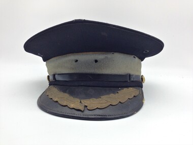
Believed to be US Army Infantry dress blue uniform cap introduced in 1954 Black peaked cap with patent leather peak. Peak is blue underside, and black upper with a row of gold oak leaves and thin leather edging. Black leather chip-strap is secured by two gilt buttons, 17 mm diameter, embossed with a hunting horn surrounded by a wreath of laurel. The sky blue hatband is edged with 2 mm wide gold embroidery. The inner headband is brown leather-like material and the lining is red fabric.Under the lining a metal tab supports the crown at the front of the cap and crown edge is reinforced by wire. The cap badge is missing (2 off 32 mm center holes) noneheadgear -
 Bendigo Historical Society Inc.
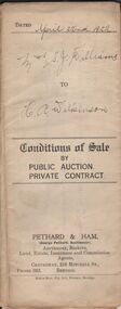
Document - H.A. & S.R. WILKINSON COLLECTION: CONDITION OF SALE
Conditions of sale by private contract dated 22nd April, 1922 issued by Pethard & Ham between Sarah Jane Williams (seller) and Henry Archibald Wilkinson (buyer) for land part of Crown allotment 54 section M Parish of Sandhurst, city and county of Bendigo described in certificate of title no. 2500 folio 499984. Also part of Crown allotments No. 53 and 54 certificate of title volume 2545 folio 508851, together with 7-roomed brick dwelling. Price 415 pounds Also for documents from Tatchell,Dunlop, Smalley & Palmer Solicitors to Mr. H.A. Wilkinson details the settlement of the Williams estateorganization, business, h.a. & s.r wilkinson real estate -
 Bendigo Historical Society Inc.
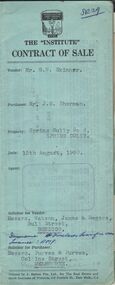
Document - H. A. & S. R. WILKINSON COLLECTION: CONTRACT OF SALE
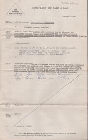
Contract of sale dated 13th August, 1960 between Mr. G. W. Skinner (vendor) and Mr. J. M. Sherman (purchaser). Solicitor for vendor: Messrs. Watson, James & Rogers, Bull Street, Bendigo. Solicitor for purchaser: Messrs. Purves & Purves, Collins Street, Melbourne. Property: Spring Gully Road, Spring Gully being thet part of Crown allotment 182 section H now comprised in Crown grant volume 8060 folio 430 together with all floor coverings, blinds, curtains, electric light fittings and shades, electric stove and electric fire in dining room. Price 5,000 pounds.organization, business, h.a. & s.r wilkinson real estate -
 Bendigo Historical Society Inc.
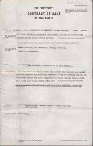
Document - H. A. & S. R. WILKINSON COLLECTION: CONTRACT OF SALE
Contract of sale of real estate dated 3rd December, 1964 between National Trustees Executors and Agency Company of Australasia as administrator of H. W. Bowden deceased (vendor) and Mr. C. Sartori (purchaser). Solicitor for vendor: Watson, James & Rogers, RACV Bldg. View Point, Bendigo. Solicitor for purchaser: Mr. H. E. Every, Dispensary Walk, Bendigo. Vacant land corner Grant & Priam Streets, Long Gully being Crown allotment 260 and 261 section A land comprised in Crown Grants volume 2195 folio 556 and volume 2190 folio 885. Price 225 pounds.organization, business, h.a. & s.r wilkinson real estate -
 Bendigo Historical Society Inc.
Document - H. A. & S. R. WILKINSON COLLECTION: CONTRACT OF SALE
Contract of sale of land dated 19th June, 1956 between Mrs. L. A. E. Ham & Sandhurst and Northern District Trustees Executors and Agency Company (vendor) and Mr. R. G. & Mrs. T. Perl. Solicitor for vendor: Hyett, Willis & Hyett, Bendigo. Solicitor for purchaser: Hyett, Willis & Hyett, Bendigo. Property: piece of land being Crown allotment3 and part of Crown allotment 1 section 130C land described in certificate of title volume 3525 folio 865, together with all improvements thereon including all blinds. Price: 4,600 pounds. Attached 3 hand written notes.organization, business, h.a. & s.r wilkinson real estate -
 Bendigo Historical Society Inc.
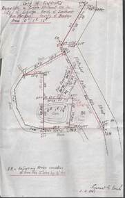
Plan - MCCOLL, RANKIN AND STANISTREET COLLECTION: PLAN OF SURVEY OF DAM SITE, 1941
McColl Rankin & Stanistreet, Plan of Survey of Dam site, Part of Crown Allotment 98 Section C, City of Bendigo, Parish of Sandhurst, County of Bendigo. Signed by Garnet G Birch 1 Feb 1941. 33.5 x 43. Attached is a Copy of Field notes, Dam Site in Crown Allotment 198 Sec. City of Bendigo, Parish of Sandhurst. True Meridian, County of Bendigo, Area 0A 1R 16P. Signed Garnet G Birch, 1/2/1941. Drawn in red and black pen. 20.8 x 33. Both maps are for Deborah Extended Gold Mining Co. No Liabilityorganization, mining, deborah extended gold mining co nl, mccoll rankin & stanistreet, plan of survey of dam site -
 Dandenong/Cranbourne RSL Sub Branch
Cap Badge, Black Watch, 1902-1935
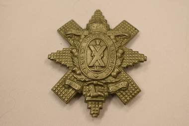
Cap Badge ,Black Watch, Royal Highlanders 1902-1935. Badge features a rayed and faceted star similar to the Star of the Order of Thistles. Upon the centre, within a wreath of thistles, an oval frosted circle bears the burnished motto: 'Nemo Me Impune Lacesset' ( Meaning no one attacks me with impunity) This is surmounted by a monarchial crown. Within the circlet the figure of St Andrew is depicted holding his cross on a frosted ground On either side of the crown bears ' The Royal Highlanders' . On the bottom of the badge a scroll with the words 'Black Watch". refer https://collection.nam.ac.uk/detail.php?acc=1963-12-74-1See "Description" -
 Flagstaff Hill Maritime Museum and Village
Domestic object - Desert Spoon, c.1878
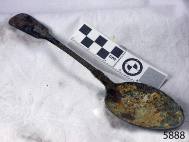
Context: This dessert spoon is from the wreck of the Loch Ard, which sailed from Gravesend, London 1878. The manifest listed an array of manufactured goods being exported to the Colony of Victoria. Included in the cargo manifest was a large number of hardware & cutlery items. The spoon is representative of similar items of silver electro-plated cutlery salvaged from the Loch Ard wreck site, comprising nickel silver electroplated spoons and forks of various sizes but all sharing the same general shape and design. Some of the pieces display their makers’ mark of William Page & Co Birmingham UK. Within the Flagstaff Hills cutlery collection donated from the Loch Ard, maker’s marks are often obscured by sedimentary accretion or verdigris after a century of submersion in the ocean. However sufficient detail has survived to indicate that the collection of samples of electroplated cutlery probably originated from the same cargo consignment from the Loch Ard and were made by William Page & Co. Of Birmingham England. William Page was born in 1811 and died in 1885. He was active as a manufacturer of cutlery from 1829 with premises at 74 Belmont Rd, Dales End as a "close plater" (someone who works sheet metal), and he began electroplating in 1855. William Page & Co was also active from 1880 at Cranemore St, Cattle’s Grove also 55 Albion St, Birmingham, and in 1936 the firm became an Ltd company. The firm used the trademarks "Asrista, Bolivian Silver, Silverite, Roman Silver, Romanian Silver, and Trevor Plate. In 1938 William Page was a supplier to the British Government, marking its products with the broad arrow symbol and was also present at Sheffield. (See additional notes note section this document for more information on Electro Plating and its makers marks.) History of the Loch Ard: The Loch Ard got its name from "Loch Ard" a loch that lies to the west of Aberfoyle, and the east of Loch Lomond. It means "high lake" in Scottish Gaelic. The vessel belonged to the famous Loch Line which sailed many vessels from England to Australia. The Loch Ard was built in Glasgow by Barclay, Curdle, and Co. in 1873, the vessel was a three-masted square-rigged iron sailing ship that measured 79.87 meters in length, 11.58 m in width, and 7 m in depth with a gross tonnage of 1693 tons with a mainmast that measured a massive 45.7 m in height. Loch Ard made three trips to Australia and one trip to Calcutta before its fateful voyage. Loch Ard left England on March 2, 1878, under the command of 29-year-old Captain Gibbs, who was newly married. The ship was bound for Melbourne with a crew of 37, plus 17 passengers. The general cargo reflected the affluence of Melbourne at the time. Onboard were straw hats, umbrellas, perfumes, clay pipes, pianos, clocks, confectionery, linen, and candles, as well as a heavier load of railway irons, cement, lead, and copper. There were other items included that were intended for display in the Melbourne International Exhibition of 1880. The voyage to Port Phillip was long but uneventful. Then at 3 am on June 1, 1878, Captain Gibbs was expecting to see land. But the Loch Ard was running into a fog which greatly reduced visibility. Captain Gibbs was becoming anxious as there was no sign of land or the Cape Otway lighthouse. At 4 am the fog lifted and a lookout aloft announced that he could see breakers. The sheer cliffs of Victoria's west coast came into view, and Captain Gibbs realised that the ship was much closer to them than expected. He ordered as much sail to be set as time would permit and then attempted to steer the vessel out to sea. On coming head-on into the wind, the ship lost momentum, the sails fell limp and Loch Ard's bow swung back towards land. Gibbs then ordered the anchors to be released in an attempt to hold their position. The anchors sank some 50 fathoms - but did not hold. By this time the ship was among the breakers and the tall cliffs of Mutton Bird Island rose behind. Just half a mile from the coast, the ship's bow was suddenly pulled around by the anchor. The captain tried to tack out to sea, but the ship struck a reef at the base of Mutton Bird Island, near Port Campbell. Waves subsequently broke over the ship and the top deck became loosened from the hull. The masts and rigging came crashing down knocking passengers and crew overboard. When a lifeboat was finally launched, it crashed into the side of Loch Ard and capsized. Tom Pearce, who had launched the boat, managed to cling to its overturned hull and shelter beneath it. He drifted out to sea and then on the flood tide came into what is now known as Loch Ard Gorge. He swam to shore, bruised and dazed, and found a cave in which to shelter. Some of the crew stayed below deck to shelter from the falling rigging but drowned when the ship slipped off the reef into deeper water. Eva Carmichael a passenger had raced onto the deck to find out what was happening only to be confronted by towering cliffs looming above the stricken ship. In all the chaos, Captain Gibbs grabbed Eva and said, "If you are saved Eva, let my dear wife know that I died like a sailor". That was the last Eva Carmichael saw of the captain. She was swept off the ship by a huge wave. Eva saw Tom Pearce on a small rocky beach and yelled to attract his attention. He dived in and swam to the exhausted woman and dragged her to shore. He took her to the cave and broke the open case of brandy that had washed up on the beach. He opened a bottle to revive the unconscious woman. A few hours later Tom scaled a cliff in search of help. He followed hoof prints and came by chance upon two men from nearby Glenample Station three and a half miles away. In a complete state of exhaustion, he told the men of the tragedy. Tom then returned to the gorge while the two men rode back to the station to get help. By the time they reached Loch Ard Gorge, it was cold and dark. The two shipwreck survivors were taken to Glenample Station to recover. Eva stayed at the station for six weeks before returning to Ireland by steamship. In Melbourne, Tom Pearce received a hero's welcome. He was presented with the first gold medal of the Royal Humane Society of Victoria and a £1000 cheque from the Victorian Government. Concerts were performed to honour the young man's bravery and to raise money for those who lost family in the disaster. Of the 54 crew members and passengers on board, only two survived: the apprentice, Tom Pearce, and the young woman passenger, Eva Carmichael, who lost her family in the tragedy. Ten days after the Loch Ard tragedy, salvage rights to the wreck were sold at auction for £2,120. Cargo valued at £3,000 was salvaged and placed on the beach, but most washed back into the sea when another storm developed. The wreck of Loch Ard still lies at the base of Mutton Bird Island. Much of the cargo has now been salvaged and some items were washed up into Loch Ard Gorge. Cargo and artifacts have also been illegally salvaged over many years before protective legislation was introduced in March 1982. One of the most unlikely pieces of cargo to have survived the shipwreck was a Minton majolica peacock- one of only nine in the world. The peacock was destined for the Melbourne 1880 International Exhibition. It had been well packed, which gave it adequate protection during the violent storm. Today the Minton peacock can be seen at the Flagstaff Hill Maritime Museum in Warrnambool. From Australia's most dramatic shipwreck it has now become Australia's most valuable shipwreck artifact and is one of very few 'objects' on the Victorian State Heritage Register. The shipwreck of the Loch Ard is of significance for Victoria and is registered on the Victorian Heritage Register ( S 417). Flagstaff Hill has a varied collection of artifact s from Loch Ard and its collection is significant for being one of the largest accumulation of artifact s from this notable Victorian shipwreck. The collection's object is to also give us a snapshot into history so we can interpret the story of this tragic event. The collection is also archaeologically significant as it represents aspects of Victoria's shipping history that allows us to interpret Victoria's social and historical themes of the time. The collection's historical significance is that it is associated unfortunately with the worst and best-known shipwreck in Victoria's history.Large Nickel Silver copper plated teaspoon, fiddle-back design handle, narrow stem with flared collar and elongated bowl.Makers’ mark “W” & “P” placed within a raised diamond outline, which is in turn contained within a sunken crown shape identifying the manufacturer as William Page & Co of Birmingham just visable.flagstaff hill maritime museum, shipwreck coast, great ocean road, loch line, loch ard, mutton bird island, loch ard gorge, electroplated cutlery, loch ard shipwreck, william page and co, birmingham brass plating, table spoons -
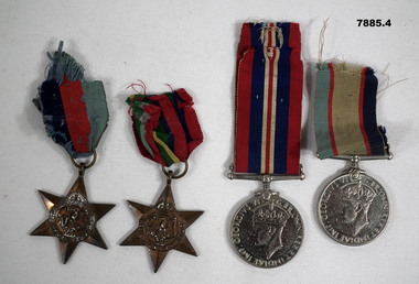 Bendigo Military Museum
Medal - SERVICE MEDALS, WW2
Relates to "Edmond (Tim) Grey Bates" RAAF 20841. Enlisted 30/5/41. Discharges 30/6/45. Cpl. 1 Wireless & Gunnery School. Pacific Star awarded for Service in WW2. War medal was for all who served in the armed services or Merchant Navy in WW2. Australian Service medal was specific to Australian Citizens.Four WW2 Service Medals. 1. 1939-45 Star. 6 pointed Star of yellow copper and zinc alloy with a dark blue, red and light blue ribbon. Attached to a ring at the top. 2. Pacific Star - 6 pointed star of copper and zinc alloy with a small ring at top and colours on ribbon of red, dark blue, green, yellow, cream, dark blue and red. 3. War Medal 1939-45. Round silver medal in copper nickel with fixed straight bar on top. Attached ribbon is a combination of red, dark blue and white. 4. Australian Service Medal - round silver color medal of nickel alloy with fixed star and bar on top and ribbon colours of light blue, red, white and dark blue. 1.& 2. A crown and "GRJ VI" on front. 3. King George VI one side and roaring lion on other. 4. King George VI on one side and Commonwealth Emblem on other.medals, raaf, edmond grey bates -
 Warrnambool and District Historical Society Inc.
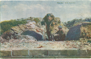
Postcard - A Gallant Rescue Under Fire, 1914-1918
This is number 16 of 27 items in the Daisy Vickers collection of World War One memorabilia. These items were sent or given to Daisy Ogier (nee Vickers) during World War One by Corporal Arthur Anderson who enlisted from Warrnambool in 1915 at the age of 21. He served in Egypt and France and returned to Australia in 1919. Daisy Ogier (1907-1987) was a student and then a teacher at Warrnambool Technical School with her early teaching years there from 1925 to 1936 and in 1949. She became the head mistress from 1950 to 1963 and in 1968. She officially retired in 1976. Daisy Vickers was one of the best loved and dedicated teachers that the school ever had. She married the Reverend Fred Ogier and continued her association with the school after her husband's death.This card is interesting because of its association with World War One and two local people Daisy Vickers and Arthur AndersonThis postcard shows a photograph of a soldier carrying another soldier under fire. A Gallant Rescue Under Fire. This man saved twenty lives like this. Office photograph Crown Copyright Reserved "Daily Mail" Miss Daisy Vickers Bushfield Post Office Victoria Aus.daisy vickers, arthur anderson, warrnambool technical school, world war 1 postcard -
 Learmonth and District Historical Society Inc.
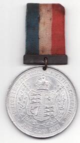
Medal - Coronation 1911, King George V & Queen Mary,Coronation 1911,medal, 00/00/1911
These medals were mass produced for the coronation of King George V & Queen Mary which took place on the 6th July 1911. George was the son of King Edward V11 & Princess Alexandra.Commemoration of the coronation of King George V & Queen Mary in 1911A round silver plated medal with KING GEORGE V & QUEEN MARY on the front, on the back is the British Monarchy "Coat of Arms", attached is also a red, white & blue, small ribbon. On the front is the heads of KING GEORGE V & QUEEN MARY along with their names, on the back is the British Monarchy "Coat of Arms", with a crown above it, surrounded by the words "TO COMMEMORATE THEIR MAJESTIES CORONATION. JUNE 22. 1911".medal, queen mary, 1911, king george v -
 Dandenong/Cranbourne RSL Sub Branch
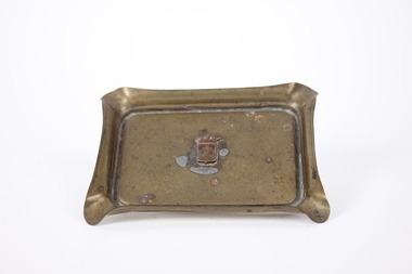
Souvenir - Ashtray, circa 1920
World War I ashtray made in Ypres, France'Trench Art' ashtray with coat of arms in centre. rectangular, made in brass with cigarette holder grooves at each corner Coat of arms, vertical rectangle with small point as base, surmounted by open crown. Top third of shield features Cross of Lorraine on burgundy background, lower two thirds contains textured cross. ashtray, trench art, wwi -
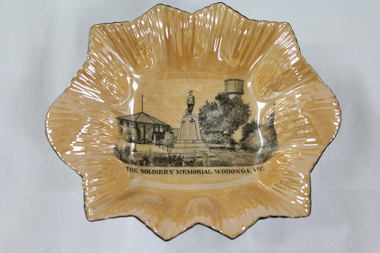 Wodonga & District Historical Society Inc
Memorabilia - Woodland Grove Souvenir dish made by RKG under licence for Royal Sydney China, Czechoslovakia, c. 1920, RKG, c. 1921 - 1938
A wide range of souvenirs have been produced to commemorate Wodonga and its landmarks over time. These items document key changes in Wodonga and its heritage. The producers mark on the plate was used by the company RKG Czechoslovakia between 1921 and 1938 This plate depicts three key landmarks in Wodonga. THE SOLDIERS' MEMORIAL in Wodonga was unveiled on Tuesday 18th November 1924. It was designed by Messrs. Hosken & Co., of Hawthorn, Victoria. The monument is all of Australian workmanship. The pedestal is made of Harcourt granite, 9ft x 9ft at the base, and rising in seven courses to a height of 10ft 2in. The emblems (rising sun and wreath) are of bronze, and the lettering of the inscription and names of fallen soldiers are in raised lead letters. Originally the Memorial was completed with a full life size, 6ft in height, sculpture of an Australian soldier in Sicilian marble. The memorial bore the inscriptions: ERECTED BY THE RESIDENTS OF WODONGA AND DISTRICT IN MEMORY of the Men of this Town and District who fell in the Great War, 1914-1919, Also in grateful recognition of the men who served and returned. “Lest We Forget.” In 1982, due to frequent vandalism and high cost of materials to repair, the soldier statue was removed and later installed at the RSL Rooms. THE WATER TOWER is a major landmark of High Street, Wodonga. It began operation from 1924 until it ceased operation in 1952. It stood unused for a decade until the lower section was modified and put to use as “ The Tower’s Cobbler’s Inn” in 1962. In 1972 Wodonga City Council proposed to demolish the Tower. Their suggestion received an unfavorable response from the city’s citizens, so the Tower still stands today. THE BAND ROTUNDA was officially opened on Sunday 5th September 1920 at the naming of the triangular reserve at the corner of High and Hovell Streets as Woodland Grove. The Wodonga Band gave a public performance on this occasion. The tri-coloured ribbon, which stretched across the entrance to the Rotunda was cut by Mrs R.H Murphy, daughter of Mr. John Woodland, secretary of the Wodonga Shire Council for 35 years, after whom the area was named. The rotunda has since been moved to Martin Park, Wodonga. Small china pieces carrying scenic views of holiday destinations were a popular kind of souvenir during much of the 20th century. These items have local and social significance as they reflect the landmarks or local features valued by the community over time. An apricot irregular shaped dish made from lustre ware with a drawing of the Wodonga Soldiers Memorial, Water Tower and Rotunda. The manufacturer's mark is imprinted on the base. Text under the image says 'THE SOLDIERS' MEMORIAL. WODONGA. VICManufacturer's trademark printed on base, in orange paint, in a circular formation 'ROYAL SYDNEY CHINA / MADE IN / CZECHOSLOVAKIA', within circular formation '(crown) / RK / G' ('RK / G' within circle with handles).porcelain, wodonga, royal sydney china, soldier memorial, wodonga souvenirs -
 St Kilda Historical Society
Photograph - Photo map, 28/01/1951
One of a series of photo-maps produced for the Department of Crown Lands and Survey (1857-1983). For correlation with a current map, and access to other historical photo maps of Victoria, see the Historic Photo-Maps Index published by the Department of Environment, Land, Water and Planning at https://services.land.vic.gov.au/DELWPmaps/historical-photomaps/Black and white aerial photograph1424-45 SECRET 534 Run 18 Lens 12" Melbourne Metropolitan 12150 28.1.51 M639albert park, st kilda junction, st kilda pier, catani gardens, st kilda, prahran, albert park lake, 1951, middle park, st kilda beach, windsor -
 St Kilda Historical Society
Photograph - Photo map, 17/01/1951
One of a series of photo-maps produced for the Department of Crown Lands and Survey (1857-1983). For correlation with a current map, and access to other historical photo maps of Victoria, see the Historic Photo-Maps Index published by the Department of Environment, Land, Water and Planning at https://services.land.vic.gov.au/DELWPmaps/historical-photomaps/Black and white aerial photograph1414-21 538 Run 19 Lens 12" Melbourne Metropolitan 12150 17.1.51 M586st kilda, st kilda botanical gardens, peanut farm, elwood, 1951, point ormond, elwood canal, st kilda beach -
 St Kilda Historical Society
Photograph - Photo map, 28/01/1951
One of a series of photo-maps produced for the Department of Crown Lands and Survey (1857-1983). For correlation with a current map, and access to other historical photo maps of Victoria, see the Historic Photo-Maps Index published by the Department of Environment, Land, Water and Planning at https://services.land.vic.gov.au/DELWPmaps/historical-photomaps/Black and white aerial photograph1424-118 534 Run 20 Lens 12" Melbourne Metropolitan 12150 18.1.51M639elwood, point ormond, elwood park, elsternwick park, elwood beach, 1951 -
 St Kilda Historical Society
Photograph - Photo map, 17/01/1951
One of a series of photo-maps produced for the Department of Crown Lands and Survey (1857-1983). For correlation with a current map, and access to other historical photo maps of Victoria, see the Historic Photo-Maps Index published by the Department of Environment, Land, Water and Planning at https://services.land.vic.gov.au/DELWPmaps/historical-photomaps/Black and white aerial photograph1414-20 538 Run 19 Lens 12" Melbourne Metropolitan 12150 17.1.51 M586elwood, elsternwick, st kilda east, balaclava, ripponlea, 1951 -
 St Kilda Historical Society
Photograph - Photo map, 28/01/1951
One of a series of photo-maps produced for the Department of Crown Lands and Survey (1857-1983). For correlation with a current map, and access to other historical photo maps of Victoria, see the Historic Photo-Maps Index published by the Department of Environment, Land, Water and Planning at https://services.land.vic.gov.au/DELWPmaps/historical-photomaps/Black and white aerial photograph1424-44 534 Run 18 Lens 12" Melbourne Metropolitan 12150 28.1.51 M639 -
 St Kilda Historical Society
Photograph - Photo map, 28/01/1951
One of a series of photo-maps produced for the Department of Crown Lands and Survey (1857-1983). For correlation with a current map, and access to other historical photo maps of Victoria, see the Historic Photo-Maps Index published by the Department of Environment, Land, Water and Planning at https://services.land.vic.gov.au/DELWPmaps/historical-photomaps/Black and white aerial photograph1424-43 534 Run 18 Lens 12" Melbourne Metropolitan 12150 28.1.51 M639armadale, malvern, st kilda cemetery, caulfield north, st kilda east, 1951 -
 St Kilda Historical Society
Photograph - Photo map, 30/01/1960
One of a series of photo-maps produced for the Department of Crown Lands and Survey (1857-1983). For correlation with a current map, and access to other historical photo maps of Victoria, see the Historic Photo-Maps Index published by the Department of Environment, Land, Water and Planning at https://services.land.vic.gov.au/DELWPmaps/historical-photomaps/Black and white aerial photographVic 1093-62 Melbourne & Metropolitan Project Run 21 30.1.60 Lens 10" 8.200middle park, albert park, catani gardens, st kilda west, 1960 -
 St Kilda Historical Society
Photograph - Photo map, 30/01/1960
One of a series of photo-maps produced for the Department of Crown Lands and Survey (1857-1983). For correlation with a current map, and access to other historical photo maps of Victoria, see the Historic Photo-Maps Index published by the Department of Environment, Land, Water and Planning at https://services.land.vic.gov.au/DELWPmaps/historical-photomaps/Black and white aerial photographVic 1093-60 Melbourne & Metropolitan Project Run 21 30.1.60 Lens 10" 8.200st kilda, albert park, prahran, windsor, south yarra, 1960 -
 St Kilda Historical Society
Photograph - Photo map, 30/01/1960
One of a series of photo-maps produced for the Department of Crown Lands and Survey (1857-1983). For correlation with a current map, and access to other historical photo maps of Victoria, see the Historic Photo-Maps Index published by the Department of Environment, Land, Water and Planning at https://services.land.vic.gov.au/DELWPmaps/historical-photomaps/Black and white aerial photographVic 1092-36 Melbourne & Metropolitan Project Run 22 30.1.60 Lens 10" 8.200st kilda, st kilda pier, st kilda beach, catani gardens, 1960 -
 St Kilda Historical Society
Photograph - Photo map, 30/01/1960
One of a series of photo-maps produced for the Department of Crown Lands and Survey (1857-1983). For correlation with a current map, and access to other historical photo maps of Victoria, see the Historic Photo-Maps Index published by the Department of Environment, Land, Water and Planning at https://services.land.vic.gov.au/DELWPmaps/historical-photomaps/Black and white aerial photographVic 1092-38 Melbourne & Metropolitan Project Run 22 30.1.60 Lens 10" 8.200st kilda, st kilda beach, st kilda pier, catani gardens, 1960, st kilda botanical gardens, peanut farm -
 St Kilda Historical Society
Photograph - Photo map, 30/01/1960
One of a series of photo-maps produced for the Department of Crown Lands and Survey (1857-1983). For correlation with a current map, and access to other historical photo maps of Victoria, see the Historic Photo-Maps Index published by the Department of Environment, Land, Water and Planning at https://services.land.vic.gov.au/DELWPmaps/historical-photomaps/Black and white aerial photographVic 1092-40 Melbourne & Metropolitan Project Run 22 30.1.60 Lens 10" 8.200st kilda east, balaclava, ripponlea, st kilda cemetery, 1960 -
 St Kilda Historical Society
Photograph - Photo map, 30/01/1960
One of a series of photo-maps produced for the Department of Crown Lands and Survey (1857-1983). For correlation with a current map, and access to other historical photo maps of Victoria, see the Historic Photo-Maps Index published by the Department of Environment, Land, Water and Planning at https://services.land.vic.gov.au/DELWPmaps/historical-photomaps/Black and white aerial photographVic 1092-42 Melbourne & Metropolitan Project Run 22 30.1.60 Lens 10" 8.200malvern, caulfield, caulfield park, 1960 -
 St Kilda Historical Society
Photograph - Photo map, 30/01/1960
One of a series of photo-maps produced for the Department of Crown Lands and Survey (1857-1983). For correlation with a current map, and access to other historical photo maps of Victoria, see the Historic Photo-Maps Index published by the Department of Environment, Land, Water and Planning at https://services.land.vic.gov.au/DELWPmaps/historical-photomaps/Black and white aerial photographVic 1091-112 Melbourne & Metropolitan Project Run 23East 30.1.1960 Lens 10" 8.200elwood, point ormond, elwood park, elwood canal, 1960