Showing 10388 items
matching plan
-
 Glenelg Shire Council Cultural Collection
Plan - Original boat line plans of army diesel tug boat, 'Vigorous' (later renamed 'Emily S'), 10/07/1959
Eden Killer Whale MuseumOriginal boat line plans of army diesel tug 'Vigorous' later owned by Geoff Collett of Eden and later renamed 'Emily S' by Tony Santic. -
 Ringwood and District Historical Society
Plan, Ringwood Station Estate, Subdivision, Ringwood, Victoria - circa 1925
ID 5224 note: Further information relating to squares marked H, F, G, J, and K included in ID 5225 - Ringwood Shop and Dwelling Estate.Hand drawn plan of Ringwood Station Estate showing allotments for sale, with two typed pages attached showing land title information and sale prices.Drawn by Edyth Greenwood, phone 988 Central. Subdivision includes Station Street, Pitt Street, Bedford Road, Wantirna Road, James Street, William Street (later Kendall Street), Greenwood Avenue, Ellison Street, and Haig Street. Circles denote blocks for sale. Squares denote house properties for sale. Other features marked include location of businesses along Main Street (Maroondah Highway), cool store, railway station, shop and police station on Bedford Road, church on Station Street, site of schoolmaster's residence and State School, and location of proposed public baths. Ryner & Langford, Solicitors -
Port Melbourne Historical & Preservation Society
Plan - Pickles Street, Town of Emerald Hill and Borough of Sandridge, Sep 1881
Town of Emerald Hill and Borough of Sandridge plan for Pickles Street, including transverse and longitudinal sections - Spring to Graham. NB "bridge" near Liardet Street.Signed by Charles Clayengineering - roads streets lanes and footpaths, charles clay -
Port Melbourne Historical & Preservation Society
Plan - Construction of Liardet Street, Port Melbourne, John Foly?, Draughtsperson, 1860 - 1884
Working drawing: longitudinal section, ground plan, transverse section for the construction of Liardet Street between Nott Street and Railway Place. Between 1860 and 1884."Borough of Sandridge":"Chas Clay":"John Foly"engineering - roads streets lanes and footpaths, engineering department - borough of sandridge, charles clay, john foly, liardet street -
Port Melbourne Historical & Preservation Society
Plan - Danks Street from Pickles Street to Esplanade East, Town of Port Melbourne, 28 Feb 1893
Plan of Danks Street, from Pickles Street to Esplanade East and bearing the seal of the Borough of Port Melbourne as well as agreement to contract to carry out works.A.V. Heath (Town Surveyor):Michael Minahan (?) (Contractor):J.J. Bartlett (Mayor):Prohasky (Councillor):E.C. Crockford (Town Clerk):W. Harrison (Witness)engineering - roads streets lanes and footpaths, engineering - fences, local government - borough of port melbourne, arthur victor heath, james john bartlett, william henry prohasky, edward c crockford, town clerks, w harrison, michael minahan -
Port Melbourne Historical & Preservation Society
Plan - Coal tramway, Town Pier to Gas Works via Esplanade West, 1880s
From set of three photocopies of two plans of coal tramway, Town Pier to Gas Works via Esplanade West: Reduced size version of 656.01transport - tramways, utilities - gas, sandridge lagoon, industry - manufacturing, piers and wharves - town pier, metropolitan gas company, australasia sugar refining company, robert harper & co ltd -
Whitehorse Historical Society Inc.
Plan - Illustration, Nunawading Historical Museum, 1978
Plan of proposed display cabinet for period costumes, Nunawading Historical Museum.Plan of proposed display cabinet for period costumes, Nunawading Historical Museum, completed 11 Dec 1981. 14' : 1'0', with notes on suppliers by Harold A. Bakes.Plan of proposed display cabinet for period costumes, Nunawading Historical Museum. nunawading historical society, cabibet -
 Kew Historical Society Inc
Plan - Subdivision Plan, J R Mathers & McMillan, Heart of Richmond Estate : Richmond, 1928
"In 1928 the land on the east side of Johnson Street was subdivided in 60 lots for the ‘Heart of Richmond Estate’. The houses in the subdivision, along the east side of Johnson Street, and in the newly created Hollick, Cole and Kennedy streets were constructed from 1928 to 1937." (Source: City of Yarra Heritage Gaps Review One 2013)Portion of subdivision plan pasted on to cardboard. Area includes Johnson Street, Victoria Street, Kennedy Street, Cole Street, Hollick Street, Bennett StreetTitle Certificate Vol.2381, Folio 476130 Phillips, Fox & Masel, 440 Little Collins Street, Melbourne (Local estate agent: Jas. R. Mathers & McMIllan, 136 Cotham Road, Kew)subdivision plans - richmond (vic.), heart of richmond estate -
University of Melbourne, Burnley Campus Archives
Plan - Photocopy, Burnley Gardens, 1957
Photocopy of Department of Agriculture - Victoria. Plan of Burnley Gardens dated 16.12.1957. UCB.2.129 16 Ref. No. For Public Records Office. Buildings marked in black.burnley gardens -
University of Melbourne, Burnley Campus Archives
Plan, Student Amenities Block 1:200, 1990-2000
Student Amenities Block - Ground Floor and First Floor plan and enlargement of SAB 3 Student Lounge (print and tracing). Refer to Fire Detection System.amenities, vcah, burnley -
University of Melbourne, Burnley Campus Archives
Plan, Burnley College Faculty of Agriculture Forestry and Horticulture
site plan -
 Kew Historical Society Inc
Plan - Subdivision Plan, Jas R Mathers Son & McMillan, Macartney Estate, East Kew, c. 1925
Pru Sanderson, in her groundbreaking ‘City of Kew Urban Conservation Study : Volume 2 - Development History’ (1988), summarised the periods of urban development and subdivisions of land in Kew. The periods that she identified included 1845-1880, 1880-1893, 1893-1921, 1921-1933, 1933-1943, and Post-War Development. These periods were selected as they represented periods of rapid growth or decline in urban development. An obvious starting point for Sanderson’s groupings involved population growth and the associated economic cycles. These cycles also highlighted urban expansion onto land that was predominantly rural, although in other cases it represented the decline and breakup of large estates. A number of the plans in the Kew Historical Society’s collection can also be found in other collections, such as those of the State Library of Victoria and the Boroondara Library Service. A number are however unique to the collection.Subdivision plans are historically important documents used as evidence of the growth of suburbs in Australia. They frequently provide information about when the land was sold on which a built structure was subsequently constructed as well as evidence relating to surveyors and real estate and financial agents. The numerous subdivision plans in the Kew Historical Society's collection represent working documents, ranging from the initial sketches made in planning a subdivision to printed plans on which auctioneers or agents listed the prices for which individual lots were sold. In a number of cases, the reverse of a subdivision plan in the collection includes a photograph of a house that was also for sale by the agent. These photographs provide significant heritage information relating house design and decoration, fencing and household gardens.The Macartney Estate subdivision advertised 21 lots for sale on either side of Macartney Street (now Macartney Avenue) and Evans Road in what was then designated as East Kew. Most of the houses shown on the south side of Macartney Street then, as now, have rear entrances on Mount Street, however a number of these blocks have since been further subdivided to allow for the building of new houses on the rear of a block. Brougham Place is marked on the plan but is now called Daniell Place."C"subdivision plans - east kew, macartney estate, macartney street, mount street, evans road, brougham place -
 Bendigo Historical Society Inc.
Legal record - Land Register
Land register for duration 1924 to 1951 (!!). Register contains plans of Land sales for a broad area of Central Victorian Parish / Counties. Register has a stiff blue card cover originally bound with light brown leather spine and corners, presently in a dire condition with cover damaged and loose; plans also folded and damaged. Plans inserted as drawn plans within the register, later plans are included on tracing, paper and linen - in various degrees of condition / damage.land register, central victoria -
Bendigo Historical Society Inc.
Document - MARKS COLLECTION: NEW CHUM LINE OF REEF MAP
Plan (copy) of New Chum Line of Reef . Plan has been copied in two sections. On top of plan 'Underground survey of mines Sandhurst, New Chum Line of Reef' , plan shows longitudinal and cross section views of the workings on the reef. Shaft No. 76 marked. Datum line on top indicates 750' above sea level, on bottom of plan, bottom of shaft 2022.24 below sill. Drawn by Arthur Everett, Mining Department, Melbourne, 1884.bendigo, mining, new chum line of reef -
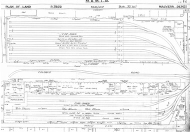 Melbourne Tram Museum
Drawing, Melbourne & Metropolitan Tramways Board (MMTB), "Malvern Depot", c1938
Set of three photocopied plans or drawings on A3 sheets of "Malvern Depot" - 15-3-1937 .1 - P7873 - Plan showing details of car sheds .2 - P7894 - Plan of Land showing overall site plan .3 - P8342 - showing details of buildings, including offices, Club Rooms in Stanhope St, No. 28 Stanhope St and sub-station.trams, tramways, drawings, depots, property, substation, malvern depot -
 Bayside Gallery - Bayside City Council Art & Heritage Collection
Map - print, Melbourne and Metropolitan Board of Works, Interim development order: Brighton, Moorabbin and Sandringham, 1959
The Melbourne and Metropolitan Board of Works (now Melbourne Water) was established in 1891. From that time, as part of their work laying water and sewerage connections, they created detailed plans of houses and other buildings in the Melbourne metropolitan area. In 1956 it acquired powers to construct and maintain highways and bridges, protect and improve the foreshores and create and maintain parks within the metropolitan region. This Interim development order comprises part of the municipalities of Brighton, Moorabbin and Sandringham and was made on 20 October 1959.brighton, moorabbin, sandringham, melbourne and metropolitan board of works, map, town planning, cartographic material, interim development order, bayside -
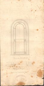 Bendigo Historical Society Inc.
Document - MARKS COLLECTION: GROUND PLAN SHOWING WINDOW OF FORTUNA
Heavy parchment plan showing line drawing of arched window. Under window 'inside elevation', ground plan, scale one inch to the foot written in black pen. On bottom of plan: purple ink stamp 'Vahland & Getzschmann, Architects, Sandhurst'.Vahland & Getzschmann, Architects, Sandhurst.bendigo, house, fortuna villa -
Port Melbourne Historical & Preservation Society
Document - Specification, Metalling and chanelling, unnamed street from Esplanade East to Esplanade West, Engineering Department, Town of Port Melbourne, Mar 1893
Specification for metalling and channelling unnamed street from Esplanade West to Esplanade East Loan Works 1893 plan 19; relates to plan 100.2Signed by JJ Bartlett (Mayor) 14.3.1893engineering - roads streets lanes and footpaths, town planning, town clerks, mayors, arthur victor heath, james john bartlett -
Port Melbourne Historical & Preservation Society
Document - Submission, C5 amendment to the Port Phillip Scheme, 1999
Submission by Meredith J Withers for Port Phillip Planning Advisory Committee, to the Panel reviewing the C5 amendment to the Port Phillip Planning Scheme, 1999town planning, built environment, meredith withers -
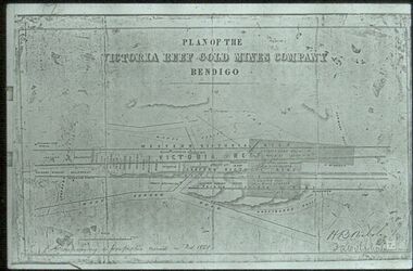 Bendigo Historical Society Inc.
Slide - ALBERT RICHARDSON COLLECTION: PLAN OF LEASES VICTORIA HILL
Slide. . Victoria Reef Gold Mines Company Mining Plan. Mount Korong Road on bottom of plan, Victoria Reef running through centre.mine, gold, victoria reef gold mines plan., bendigo mines-jack hattam collection -
Whitehorse Historical Society Inc.
Pamphlet, Nunawading 1999
Nunawading Council has produced a far reaching structure plan which plans to guide the community to the beginnings of the 21st century.Nunawading Council has produced a far reaching structure plan which plans to guide the community to the beginnings of the 21st century. This pamphlet seeks comments. Nunawading Council has produced a far reaching structure plan which plans to guide the community to the beginnings of the 21st century. local government, city of nunawading -
 Bendigo Historical Society Inc.
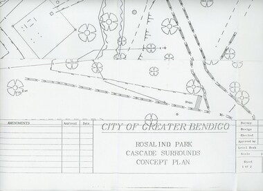
Plan - MERLE HALL COLLECTION: ROSALIND PARK CREATIVE VILLAGE BENDIGO PROJECT CONCEPT PLAN, 1993
MERLE HALL COLLECTION: ROSALIND PARK CREATIVE VILLAGE BENDIGO PROJECT Concept Plan City of Greater Bendigo Rosalind Park Cascade Surrounds Concept Plan number GB095 Sheet 1 of 2 Level Book 365, Backup No Tape 01, Computer File No. ROS QEO. Large Sheet which shows the location of utilities, vegetation, drains, embankments etc. June 1993 -
Bendigo Historical Society Inc.
Plan - MARKS COLLECTION: PLAN NEW BOILER LANSELL'S LITTLE 180 MINE
Plan drawn on buff coloured waxed paper. Written on bottom: 'No. 1 Arrangement New Boiler for Lansells Proprietary Little 180 Mine Bendigo. Scale 1/4 inch = 1 foot. Hargraves & Daggar, Consulting Engineers, Victoria Chambers Bendigo' Plan shows entry of tramway, fuel store, boiler room, stack ( 75ft ), driving platform, winding engine, view to shaft.mining, lansell's little 180 mine, george lansell, gold mining, bendigo -
 Kew Historical Society Inc
Plan - Subdivision Plan, Warne Estate, Undated
Pru Sanderson, in her groundbreaking ‘City of Kew Urban Conservation Study : Volume 2 - Development History’ (1988), summarised the periods of urban development and subdivisions of land in Kew. The periods that she identified included 1845-1880, 1880-1893, 1893-1921, 1921-1933, 1933-1943, and Post-War Development. These periods were selected as they represented periods of rapid growth or decline in urban development. An obvious starting point for Sanderson’s groupings involved population growth and the associated economic cycles. These cycles also highlighted urban expansion onto land that was predominantly rural, although in other cases it represented the decline and breakup of large estates. A number of the plans in the Kew Historical Society’s collection can also be found in other collections, such as those of the State Library of Victoria and the Boroondara Library Service. A number are however unique to the collection.The Kew Historical Society collection includes almost 100 subdivision plans pertaining to suburbs of the City of Melbourne. Most of these are of Kew, Kew East or Studley Park, although a smaller number are plans of Camberwell, Deepdene, Balwyn and Hawthorn. It is believed that the majority of the plans were gifted to the Society by persons connected with the real estate firm - J. R. Mathers and McMillan, 136 Cotham Road, Kew. The Plans in the collection are rarely in pristine form, being working plans on which the agent would write notes and record lots sold and the prices of these. The subdivision plans are historically significant examples of the growth of urban Melbourne from the beginning of the 20th Century up until the 1980s. A number of the plans are double-sided and often include a photograph on the reverse. A number of the latter are by noted photographers such as J.E. Barnes.The Warne Estate included four lots in Argyle Street, Kew. It represents a typical small-scale subdivision in this area. The lots for sale must have been further divided as there are now more houses in the street than there were blocks advertised in the subdivision. The agent left the proximity of the Outer Circle Railway off the plan. The Railway would have run along the triangular shaped lot 4. Lot 4 was offered for the sum of £600 plus the costs of footpath construction.subdivision plans - kew, warne estate -
Clunes Museum
Drawing - Plans, J BARTRAM, CIRCA 1894
PLANS FOR THE ESTABLISHMENT OF CLUNES BUTTER FACTORY.1 2 PAGE LETTER, TYPED IN PURPLE INK .2 4 PAGES OF PAPER STAPLED TOGETHER WITH HAND HANDWRITTEN MATHEMATICAL CALCULATIONS OF THE QUANTITY OF SAWDUST OR CHARCOAL REQUIRED FOR REFRIGERATION CHAMBER .3 1 PAGE DRAWING OF THE MACHINERY ROOM AT CLUNES DISTRICT BUTTER FACTORY CO. LIMITED USING RED AND BLACK INK AND BLUE PENCIL .4 1 PAGE DRAWING OF SECTION THROUG A.B .5 1 PAGE OF WAX PAPER WITH HAND DRAWN PLAN OF BRICKWORK .6 4 PAGES OF BUFF COLOURED PAPER HANDWRITTENWITH MATHEMATICAL CALCULATIONS .7 1 PAGE OF DRAWING SECTION THROUGH A.C .8 1 PAGE OF BLUE COLOURED PAPER HANDWRITTEN WITH BLACK INK AND BLUE AND ORAGE PENCIL NOTATIONS.1 LETTERHEAD J. BARTRAM & SON 18 QUEEN STREET MELBOURN .3 MACHINERY ROOM AT CLUNES DISTRICT BUTTER FACTORY CO .LIMITED .5 SCALE: 1/1/2 INCH TO THE FOOT WRITTEN IN LEAD PENCIL .7 SCALE: 2FT TO 1 INCHj bartram & son, clunes & district butter factory co. limited, lordclyde creamery -
 Federation University Historical Collection
Photograph - Colour photograph, Greg Eames, University of Ballarat Libary and Information Technology Services Planning Day, 2007
A number of photographs of activities during Planning Daylibrary planning day, its planning day, greg eames, nancy lange, library, jill nicholls, carmel grant, gaida stevens, john dixon, ash pinder, trevor day, julie lasinger, treacey wilson, aaron quarrell, andrew matheson, kim redfern, sam pitman, emily eames, ann jardine, pam goodfellow -
 Federation University Historical Collection
Photograph - Colour photograph, Greg Eames, University of Ballarat Library and Information Technology Services Planning Day, 2006
A number of photographs of activities during Planning Daylibrary planning day, its planning day, greg eames, nancy lange, library, jill nicholls, carmel grant, gaida stevens, trevor day, treacey wilson, andrew matheson, sam pitman, emily eames, pam goodfellow, frank russell, leeanne pitman, bill casey, arno besso -
 Greensborough Historical Society
Document - Folder, Peter Simmenauer, Hobson land, edited by Peter Simmenauer, 2018_07
Robert Hobson purchased 148 acres of land in Crown Portion 17 from the Crown Grantee John Brown in 1877, which was sold to George Knowles Parker and John Howard Aylwin in 1887. A major purchaser of this land east of the Greensborough Road was Mary Baird in 1929. Although Baird died in 1944, sales from her estate continued until 1956. The folder Includes relevant Old Law documents and Certificates of Title, as well as a list of sales of LP11599 allotments.Loose-leaf folder of documents - lists and plansrobert hobson, mary baird, hobson street greensborough -
 Greensborough Historical Society
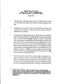
Document, Miles Lewis, Happy Hollow farm: File note, by Miles Lewis, 1994_
This is a File note written by Professor Miles Lewis, of Faculty of Architecture, University of Melbourne on Happy Hollow Farm, reputed to be the home of Emmett Whatmough and his family and subsequently by Charles Partington and his family and at time of compilation (1994) home of Dr. Christopher Bell. His examination was intended to assist in determining the age of the building, with a view to seeing whether it be nominated for inclusion on the Historic Buildings Register5 page photocopy of typescript, with house plan.happy hollow farm, christopher bell, whatmough, partington, betty bell