Showing 10480 items
matching lander
-
 The Beechworth Burke Museum Research Collection
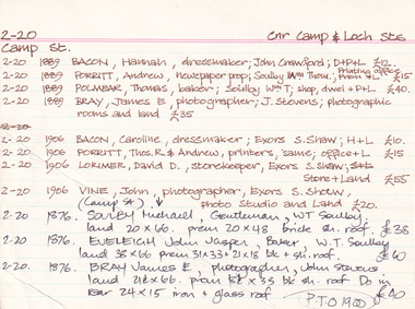
Card (Series) - Index Card, George Tibbits, Camp Street, Beechworth, 1976
George Tibbits, University of Melbourne. Faculty of Architecture, Building and Town & Regional PlanningIndex system that support the research for Beechworth : historical reconstruction / [by] George Tibbits ... [et al]Arranged by street names of BeechworthEach index card includes: street name and number of property, image of property, allotment and section number, property owners and dates of ownership, description of the property according to rate records, property floor plan with dimensions.beechworth, george tibbitsbeechworth, george tibbits -
 City of Moorabbin Historical Society (Operating the Box Cottage Museum)
Newsletter, City of Moorabbin Historical Society June 2009, June 2009
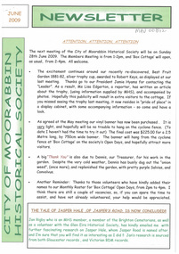
The City of Moorabbin Historical Society was formed c 1960 by a group of Moorabbin residents who were concerned that the history of the area should be preserved. A good response to a call for items related to the historical area of Moorabbin Shire brought donations of a wide variety of artefacts which are now preserved by the current members of CMHS at Box Cottage Museum . Helen Stanley, Secretary of CMHS, began producing a Newsletter for members in April 2007 to provide current information and well researched items of historical interest.Helen Stanley has produced a bi-monthly Newsletter, 2007 - 2013, for the members of the City of Moorabbin Historical Society that contains well researched interesting historical items, notification of upcoming events, current advice from Royal Australian Historical Society , Museums Australia Victoria and activities of Local Historical Societies. The Newsletter is an important record of the activities of the CMHS. Jasper Hale , transported for theft, earned his ‘Ticket of Leave, and purchased land in Dendy’s Special Survey of 1841 later known as East Bentleigh. 2 x A4 paper printed on 3 sides Issue 12 of the bi-monthly, City of Moorabbin Historical Society Newsletter produced by Society member and Secretary, Mrs Helen Stanley in June 2009. Notices of the meeting June 28th , an article in ‘The Leader’ newspaper about the Robert Keys ‘Best Fruit Garden 1881 - 82’ Trophy Cup , a large vinyl banner purchased with Grant money, and while acknowledging the Cottage garden volunteer a request for more helpers at Open Days is made. Jan Rigby, CMHS member, has provided research information about Jasper Hale b 1805 in Gloucester, England, transported to NSW 1830, ‘freed man ‘ 1839, purchased land in Dendy’s Special Survey 1844, sold this land 1846 and died 1884 in Parkes NSW. On arrival as a convict in 1830 his occupation is bricklayer and he can ‘ read and write’. CITY of MOORABBIN HISTORICAL SOCIETY / JUNE 2009 NEWSLETTERcity of moorabbin historical society, stanley helen, rigby jan, melbourne, moorabbin, brighton, cheltenham, ormond, bentleigh, market gardeners, pioneers, early settlers, moorabbin shire, box cottage museum, jasper road ormond, dendy’s special survey 1851, north road brighton, county of bourke, box h., box william, parish of moorabbin, were jonathan, hales jasper, port jackson penal colony, burgess s. william, kemble wiltshire england, stonemason, bricklayer, ‘york’ sailing ship, brummell mary, st. mary’s catholic church sydney, nelson mary ann, ‘george hibbert’ sailing ship, hale james, hale eliza, parkes new south wales gold rush, ballarat gold rush, clunes gold rush, forbes nsw gold rush, parkes historical society -
 Bendigo Historical Society Inc.
Document - LONG GULLY HISTORY GROUP COLLECTION: POSTAL HISTORY OF LONG GULLY
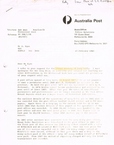
Letter to Mr D Egan from C Duggan for Manager - Public Relations - Australia Post, dated 23 February 1983. Letter mentions the history of the Long Gully Post Office. There are many gaps in the history. Mentioned are the number of letters, newspapers, Money Orders, telegrams, mail articles, postal notes and expenditure. Values of money orders, telegrams and postal notes are mentioned. Postmasters/mistresses were P Pentreath, A Pentreath, Amelia Daniel, Mrs S A Wilcock, Mark H Webb, William J H Read, Mrs Elsie Anderson, Sydney Gordon Dawson, John Henry Bennett, Miss Margaret Mulvey, John Henry Bennett, Henry William Purchase, Mr R F Warren, Mrs Margaret Cecily Kennedy, Edward Charles Landers, Mrs Margaret Landers, Shirley Egan, Brian Matthew Egan and Shirley and Max Volk.bendigo, history, long gully history group, the long gully history group - postal history of long gully, australia post, mr d egan, p pentreath, a pentreath, amelia daniel, mrs s a wilcock, mark h webb, william j h read, mrs elsie anderson, sydney gordon dawson, john henry bennett, miss margaret mulvey, henry william purchase, mr r f warren, mrs margaret cecily kennedy, edward charles landers, mrs margaret landers, shirley egan, brian matthew egan, shirley and max volk, c duggan -
 Bendigo Historical Society Inc.
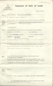
Document - H.A. & S.R. WILKINSON COLLECTION: CONTRACT OF SALE
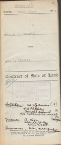
Contract of sale of land dated 24th March 1954 between Mr. E.T. Fennell (seller) and Mr. L. Riddell (buyer) for that land situate Jackass Flat being described in right to occupy residence area right No. 0251, together with weatherboard dwelling and all sundry. Price 525 pounds. Also attached receipt no.81247, dated 13 April, 1954 from the department of Crown Lands and Survey, also a letter to Messrs T.M. Williams , Watson, James, Solicitors, Bull Street Bendigo dated 26 March, 1954 signed by Mr.. Fennell instructing to pay from the proceeds of sale of property, Grassy Flat, the sum of 400 pounds to Messrs H.A. & S.R. Wilkinson of 182 Mitchell Street, Bendigo as deposit on purchase of Mr. A.L. Stuckenschmidt's property Raglan Street, White Hills.organization, business, h.a. & s.r wilkinson real estate -
 Bendigo Historical Society Inc.
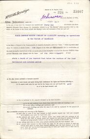
Document - H. A. & S. R. WILKINSON COLLECTION: CONTRACT OF SALE
Contract of sale of land dated 7th August, 1963 between Sandhurst and Northern District Trustees on behalf of the estate of W. H. Beecroft - Deceased (vendor) and Mr. A. L. Scinetti & Mr. J. Carriddi (purchaser). Solicitor for vendor: E. M. Monotti LL. B., View Street, Bendigo. Solicitor for purchaser: Manobo, Taylor & Taylor, Hargreaves Street, Bendigo. Property: 9 Short Street, Bendigo being parts of allotment 22A and 23 section 97C having a frontage of 65 feet 4 inches to Short Street and a depth of 82 feet 6 inches, being the land now comprised in certificate of title volume 2933 folio 421 and volume 4900 folio 928, together with all floor coverings, blinds, curtains and electric light fittings and shades. Price: 1,910 pounds.organization, business, h.a. & s.r wilkinson real estate -
 Bendigo Historical Society Inc.
Document - MCCOLL, RANKIN AND STANISTREET COLLECTION: GOLD MINING LEASE NORTH DEBORAH MINING COMPANY, 6th May, 1941
6 page indenture document plus plan, between King George VI and North Deborah Mining company, no liability, Parish of Sandhurst, dated 6th May 1941. Lease number 11146 Bendigo. ' all that piece of land above a depth of one hundred feet below the surface of the land delineated and coloured yellow' Signed by J. Stanistreet, manager. Plan shows excised area in pink. Excised below 100ft shown in yellow ( lease 11146 ) On top of plan ' Mining district of Bendigo, County of Bendigo, Parish of Sandhurst. Area section has been amended to show 1 rood, 14 perches. Leases on plan : No. 9988, 11013, 11062, 11033, 11146, 10753, 11020. Streets: Sullivan Street, Hargreaves Street, Violet Street, Queen Street, King Street. Railway line shown. Scale 8 chains to 1 inch.bendigo, mining, north deborah mining company, north deborah mine, j stanistreet, sullivan heargreaves, queen, king streets. -
 Kew Historical Society Inc
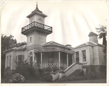
Photograph, J E & B L Rogers, 'Swinton', Swinton Avenue, c.1960
This work forms part of the collection assembled by the historian Dorothy Rogers, that was donated to the Kew Historical Society by her son John Rogers in 2015. The manuscripts, photographs, maps, and documents were sourced by her from both family and local collections or produced as references for her print publications. Many were directly used by Rogers in writing ‘Lovely Old Homes of Kew’ (1961) and 'A History of Kew' (1973), or the numerous articles on local history that she produced for suburban newspapers. Most of the photographs in the collection include detailed annotations in her hand. The Rogers Collection provides a comprehensive insight into the working habits of a historian in the 1960s and 1970s. Together it forms the largest privately-donated collection within the archives of the Kew Historical Society."The land on which Swinton was later built was first purchased by John Bakewell in 1851 and later sold to Edmund Laskey Splatt in 1858. Splatt was a member of the first provisional committee of the National Bank of Australia in Melbourne and built the first house on the land naming it Laskey Villa. By 1863 the house was occupied by Herbert Henty. The Johnson family connection with the property began with the marriage in 1858 of Annabella Johnson to David Sym - owner of The Age newspaper and owner of the adjacent property Blytheswood. Annabella's brother, Francis Johnson, bought the villa in 1876 and renamed it Swinton after his birthplace in Yorkshire. The property was later owned by the artistic Colquhoun family. The house is one of the earliest examples of the Italianate style in Victoria - the outstanding element being the tower with its cantilevered walkway and heavily bracketed pyramidal tower. (Source: Victorian Heritage Database)"Swinton. Built about 1959-60. Chap.20 Swinton. Johnson - Col"swinton, swinton avenue (kew) -
 Kew Historical Society Inc
Plan, Melbourne & Metropolitan Board of Works : Borough of Kew : Detail Plan No.1575, 1905
The Melbourne and Metropolitan Board of Works (MMBW) plans were produced from the 1890s to the 1950s. They were crucial to the design and development of Melbourne's sewerage and drainage system. The plans, at a scale of 40 feet to 1 inch (1:480), provide a detailed historical record of Melbourne streetscapes and environmental features. Each plan covers one or two street blocks (roughly six streets), showing details of buildings, including garden layouts and ownership boundaries, and features such as laneways, drains, bridges, parks, municipal boundaries and other prominent landmarks as they existed at the time each plan was produced. (Source: State Library of Victoria)This plan forms part of a large group of MMBW plans and maps that was donated to the Society by the Mr Poulter, City Engineer of the City of Kew in 1989. Within this collection, thirty-five hand-coloured plans, backed with linen, are of statewide significance as they include annotations that provide details of construction materials used in buildings in the first decade of the 20th century as well as additional information about land ownership and usage. The copies in the Public Record Office Victoria and the State Library of Victoria are monochrome versions which do not denote building materials so that the maps in this collection are invaluable and unique tools for researchers and heritage consultants. A number of the plans are not held in the collection of the State Library of Victoria so they have the additional attribute of rarity.Original survey plan, issued by the MMBW to a contractor with responsibility for constructing sewers in the area identified on the plan within the Borough of Kew. The plan was at some stage hand-coloured, possibly by the contractor, but more likely by officers working in the Engineering Department of the Borough and later Town, then City of Kew. The hand-coloured sections of buildings on the plan were used to denote masonry or brick constructions (pink), weatherboard constructions (yellow), and public buildings (grey). Plan No.1575 shows that in the area bounded by Wellington Street, Edgevale Road, Glenferrie Road, and Cotham Road, there had already been significant subdivision of land and houses constructed. As one of the highest points in Kew, as expected, there were already some significant mansions built on large allotments of land. Many of these mansions are identified by name on the plan such as ‘Kelso’, ‘Abbotsford’, ‘Clarendon’ and ‘Ashlyn’ in Cotham Road. Other houses of equal size are unnamed on the plan.melbourne and metropolitan board of works, detail plans, maps - borough of kew, mmbw 1575, cartography -
 Ringwood and District Historical Society
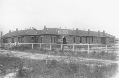
Photograph, Ringwood State School, Greenwood Avenue, Ringwood, on completion - 1922. Site was 3 1/2 acres of Count von Hariss' orchard. Land bought from A. Greenwood MLA"
Typed below photograph, "Ringwood State School - Greenwood Avenue on completion - 1922". Written on back of photograph, "1922 - Site was 3 1/2 acres of Count von Hariss(?) orchard. Land bought from A. Greenwood MLA". Identical framed photograph located in bookshelves -NWD 01-02-03 -
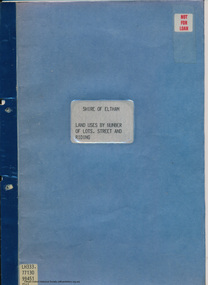 Eltham District Historical Society Inc
Document - Folder, Shire of Eltham, Land uses by number of lots, street and riding, 1984
In work undertaken by the Shire of Eltham in revising its residential multi-unit development policy, information was collated by street and number of units. The exercise was expanded to include other land uses. At the end of each Riding is given a summary of the number of the various major land uses and index to abbreviations used on the last page11 pages inside blue coverharry gilham collection, land use, streets, ridings, dwellings, units -
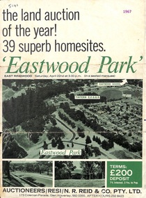 Ringwood and District Historical Society
Flyer, Land Auction Sale Advertisement, Eastwood Park, East Ringwood, Vic. - 1967
Subdivision is advertised as including homesites on former Eastwood Golf Course fairways and land contours.Double-sided advertisement for auction sale on Saturday, April 22nd, 1967, for Eastwood Park residential homesites with summary of local features and services.Subdivision includes Croydon South streets, Andrew Crescent and Banksia Court. Agents - N.R. Reid & Co Pty Ltd, 173 Coleman Parade, Glen Waverley, Tel. 560 0355 A.H. 232 8423. -
 Phillip Island and District Historical Society Inc.
Photograph
Land for the cemetery was granted in 1870, but was not surveyed until 1903. Garden of Remembrance was created in 1984.Photograph of Garden of Remembrance in Phillip Island Cemeterylocal history, photography, photographs, slides, film, phillip island cemetery, coloured photograph -
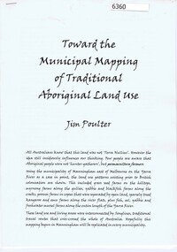 Greensborough Historical Society
Booklet, Toward the municipal mapping of traditional aboriginal land use, by Jim Poulter, 2017c
Using Manningham as an example, aboriginal land use patterns are shown, together with interconnecting songlines.10 p., typescriptmanningham, songlines, aborigines -
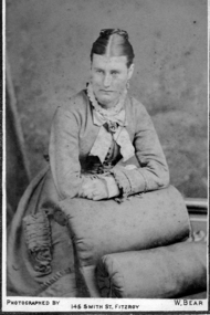 Greensborough Historical Society
Photograph - Digital image, Mrs Mitchell, 1882c
Photograph of Mrs Mitchell. The Mitchell house was situated in Hailes Street on land that went to the river. Digital copy of black and white photograph.mitchell family -
 Ringwood and District Historical Society
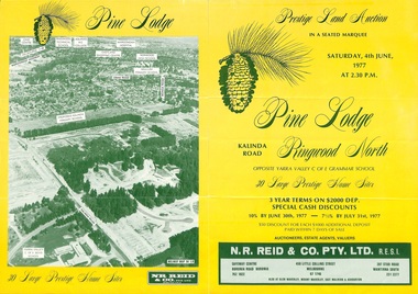
Flyer, Land Auction Sale Brochure, Pine Lodge, Ringwood North, Victoria - 1977
Refer also to Reg. No. 5172 for Pine Lodge Land Auction 3rd release, 1978.Yellow double-sided real estate auction notice with green print showing aerial photograph and map of subdivision layout and summary of local features and services for Pine Lodge, Kalinda Road, Ringwood North. Auction date, Saturday, 4th June, 1977, at 2:30pm.Subdivision plan includes Parkgate Drive, Wood-Church Close, and Pensby Court. (Agent) N.R. Reid & Co. Pty. Ltd., Safeway Centre, Boronia Road, Boronia (Phone) 762 1022, 450 Little Collins Street, Melbourne (Phone) 67 1746, and 207 Stud Road, Wantirna South (Phone) 231 2277. -
 Ringwood and District Historical Society
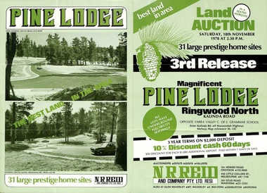
Flyer, Land Auction Sale Brochure, Pine Lodge, Ringwood North, Victoria - 3rd Release 1978
Refer also to Reg. No. 5171 for Pine Lodge Land Auction previous release, 1977.Green tri-fold advertisement for auction of home sites, with map of subdivision, photographs, and summary of local features and services for Pine Lodge, Kalinda Road, Ringwood North - 3rd release - Auction date, Saturday, 18th November, 1978, at 2:30pm.Subdivision plan includes Mundara Drive, Bidston Court, Parkgate Drive, Frodsham Road, and Bebington Close. (Agent) N.R. Reid & Co. Pty. Ltd., 10A Hewish Road, Croydon (Phone) 725 0999, 450 Little Collins Street, Melbourne (Phone) 67 1746, and 207 Stud Road, Wantirna South (Phone) 221 2222. -
 Federation University Historical Collection
Photograph - Colour, Chatham-Holmes Collection: On the road to Burrumbeat, 1987
Philip Chatham was responsible for the sub-division located on the road to Burrumbeat. Preparations for land sales.chatham-holmes collection, philip chatham, burrumbeat, land sales -
Tatura Irrigation & Wartime Camps Museum
Book, Warwick Finlay, The Doctor, The Captain, The Poet and Others, 2004
This book was printed to commemorate the 150th Anniversary of the survey, naming of the town and sale of land at Murchison.Black and white cover featuring the Goulburn River and portraits of Doctor McMillan, Captain John Murchison and Orion Horne over and early plan of Murchison Townshipmurchison -
Tatura Irrigation & Wartime Camps Museum
Booklet, Making A Crust In The Depression and Entertaining Ourselves When Young, 1991
Stories of life on the land, early 1900's and how the young people entertained themselves,White booklet, black lettering, stories of early farming and fruit growing. Kyabram and Lancaster area.farming in the 1900's, life on the land -
Clunes Museum
Book, ROBERT BELL AND ASSOCIATES P/L BALLARAT, LIST OF THOSE WHO PURCHASED LAND AT AUCTION IN BUNINGYONG 1851-1856, 2001
HISTORICAL TRANSCRIPTION AND COMPLATION OF LAND PURCHASED AT BUNINYONG MID 1800'SORANGE COVERED BOOKLET WITH THE TITLE PRINTED ON THE FRONT COVERnon-fictionHISTORICAL TRANSCRIPTION AND COMPLATION OF LAND PURCHASED AT BUNINYONG MID 1800'Slocal history, book, buninyong -
 National Wool Museum
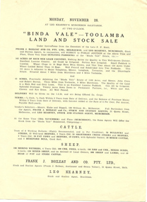
Brochure, "Binda Vale" Toolamba land and stock sale
"Binda Vale" Toolamba land and stock sale Monday November 28" Leo Kearneypastoral industry - history, binda vale, toolamba -
 Whitehorse Historical Society Inc.
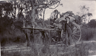
Photograph, Mr. Isaac Scott
Mr. Isaac Scott owned land in Mitcham. Scott Street named after him.Mr. Isaac Scott on Jinker with male friend.scott, isaac, scott street, mitcham -
 Ballarat Heritage Services
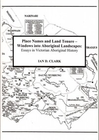
Book, Place Names and Land Tenure: Windows into Aboriginal Landscapes: Essays in Victorian Aboriginal History
Place Names and Land Tenure was published by BHS Publishing and written by Ian D. Clark. -
 Greensborough Historical Society
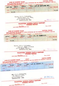
Financial record - Account, Shire of Diamond Valley, Shire of Diamond Valley rates notices 1969-1970, 26/03/1958
3 Shire of Diamond Valley Rates assessments issued jointly to Trevor and Gary Partington and their sisters, Mrs Elinor Rowe and Mrs Faye Fort. The locations of the land are Lot 41 Church Street and Lot 67 Scotland Avenue Greensborough. It is possible that this land was purchased by Alan Partington in his adult children's names.Part of the property owned by the Partington family in the original Greensborough farmland. 3 Rates notices, printed in red text with black typed details.Date stamped with rubber stampalan partington, william alan partington, partington family, land deals greensborough, church street greensborough, scotland avenue greensborough -
 Hume City Civic Collection
Photograph, c1970s
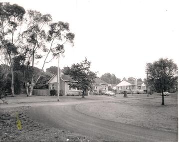
A number of houses were built within the Sunbury Asylum grounds to house administrators and staff, and their families, who worked at the asylum. After the asylum was closed down and the main asylum buildings were taken over by Victoria University, the surrounding land was developed for housing by the Urban Land Authority, the administrators houses were demolished.A black and white photograph of two bungalow style houses built along a formed but unsurfaced road. A Mini-minor car is parked on the grass outside the first house and a Holden sedan is parked by the curb outside the other house. There are trees growing along the nature-strip and in the background.Written on the back in penci: 1139-8lsunbury asylum, wishart, chas. h., george evans collection -
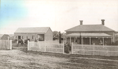 City of Moorabbin Historical Society (Operating the Box Cottage Museum)
Photograph - 115 Jasper Road, Bentleigh, Allan / Grewer Estate, c. 1890's
115 Jasper Road, Bentleigh East was a market garden owned by James Allan. In 1880 the property was transferred to David Grewar (Gruar) who had married James' niece Mary Allan. In 1926 part of the land was subdivided and sold as residential blocks. The block with the house pictured remained in the family until 1969. The land now forms part of Our Lady of Sacred Heart College. The description of the land owned by David Kidd Grewer (also spelt Gruar) in 1885: Fourteen acres or thereabouts at the corner of Jasper Road and Patterson’s Road East Brighton being part of Crown Block of 5720 acres Parish of Moorabbin County of Bourke being land comprised in Certificate of Title Volume 1344 Folio 268692 on which is erected a 4 roomed brick house with 2 rooms of wood at the rear and stable and a 2 roomed weatherboard cottage valued as under: 14 acres of land less crops £629.0.0 4 roomed brick house £250.0.0 Other buildings £50.0.0 2 roomed weatherboard cottage £35.0.0 Early pioneer family of the City of Moorabbin.Black and White photo in picture framegrewar, market garden, moorabbin, bentleigh, jasper road, housing, pioneer, james allan, orchard -
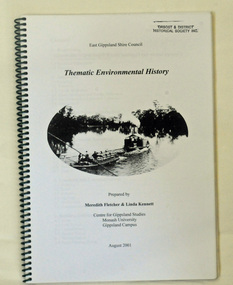 Orbost & District Historical Society
book, Thematic Environmental History, 2001
This booklet was prepared for the East Gippsland Shire Council in August 2001.A Thematic Environmental History identifies how key patterns of development have influenced the culture of the area and the natural and built environment. The document is not a social history but usually provides the context for future heritage studies and assessments and would provide input to the preparation of a Heritage Action Plan. This booklet prepared for the East Gippsland Shire councilA spiral bound book of 75 pp, titled Thematic Environmental History, prepared by Meredith Fletcher and Linda Kennett for the Centre for Gippsland Studies, Monash University, Gippsland Campus. On the front cover is a black and white drawing of a paddle steamer towing a barge along a river. It contains information on the discovery, settlement and land usage of East Gippsland as well as the development of transport, communication and cultural institutions. Copywright held by East Gippsland Shire Council and Department of Infrastructureenvironmental-study-east-gippsland -
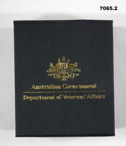 Bendigo Military Museum
Medal - MEDAL, SERVICE to AUSTRALIA & BOX, Royal Australian Mint
Medallion was produced by the Royal Australian Mint and given to members who served with Australian Forces or her Allies between 1939 - 1945. This was on the 60th Anniversary of the end of WW2. Given to Tony Cork who was in the Merchant Navy, England 1939-45.1. Gold coloured coin medallion produced by Royal Mint. On one side of the coin is the Commonwealth Coat of Arms with the reverse side symbolising the Navy, Army and AirForce through the depiction of sea, land and air over a stylized map of Australia. 2. Contained in a hard cardboard black box inscribed with gold writing and Commonwealth emblem and medal lays in a felt recess within the box. 1. One side inscribed "World War 2", "60 years""1945 - 2005". and stylized map of Australia. Other side inscribed around Rim "World War 2"and "Service to Australia" with Commonwealth of Australia emblem in centre. 2. Box on top has Commonwealth Emblem and "Australian Govt", "Dept of Veteran Affairs". Inside "60th Ann of WW2".medal, 60th anniversary ww2 -
Glenelg Shire Council Cultural Collection
Leisure object - Board Game, Strategy, n.d
a)'Strategy' war board game. heavy card board, folds in half, red and blue outside with black and white photo of 3 servicemen (army, navy, airforce) playing strategy. Inside, land, sea, air depicted by different colours, leaflet of rules b) Rothman's cigarette packet containing coloured metal counters for use with Strategy. 12 army, 8 navy, 4 airforcestrategy, game, board game, recreation, leisure -
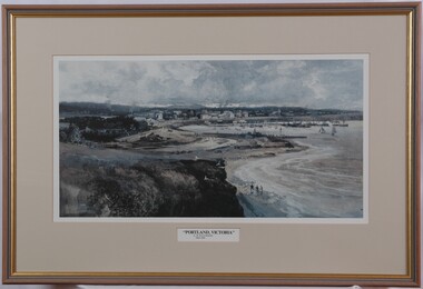 Glenelg Shire Council Cultural Collection
Print, Albert Henry Fullwood, Portland Victoria, c. 1886
Scene of Portland Harbour. View includes people walking on beaches, jetties, morred boats (some with sails, some without). Upper centre of image shows a town, with a church to the right. To the left centre is a planned garden with people promenading. In foreground is empty land with a few seagulls. A train track enters the image on bottom centre. Print is predominantly in shades of blue, grey and brown. Framed, no glass.Front: A. H. Fullwood Back: (no insciptions)print, portland harbour