Showing 2471 items matching " township"
-
 Queenscliffe Maritime Museum
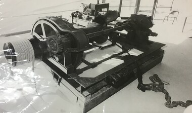
Photograph - Motor Winch
The winch was relocated to the Queenscliff Maritime Museum when the shed was moved from Fishermen's Pier [when demolished] and relocated to its present location at the end of the Queenscliff Pier. The Lifeboat shed is an iconic building for the township of Queenscliff. It once was located on the now demolished Fishermen's Pier and relocated to the current Queenscliff Pier. However, the motor winch that used to be housed there is now in pride of place adjacent to the Queenscliffe lifeboat which it served for many years. Photograph of a motor winch from the 'Queenscliffe' Lifeboat Shed.queenscliffe lifeboat service, lifeboat shed, fishermen's pier, queenscliff pier -
 Otway Districts Historical Society
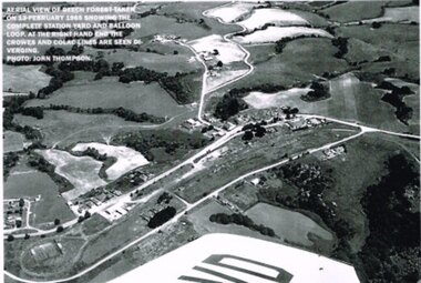
Photograph, R. Preston, Aerial view: Beech Forest, 1965, 13 February 1965
B/W. Aerial view of Beech Forest showing the complete station yard including the balloon loop (incorporating the two tennis courts), two ex-departmental residences, the station building and where the Colac and Crowes lines diverged. As well Beech Forest Hall, council offices and Shire Secretary's house, Denherts Track, and Main Road are shown.beech forest; railways; township; aerial; -
 Heytesbury District Historical Society Inc.
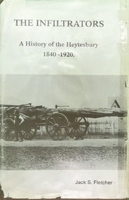
Book, The Shire of Heytesbury, The Infiltrators :A History of the Heytesbury 1840-1920 by Jack S. Fletcher, First Edition 1985
The book relates to the triumphs & the achievements, the hardships & the tribulations, of the pioneers & settlers of the district.This book gives a detailed history of the Heytesbury district, including the settlerment of the townships of Port Campbell, Timboon, Princetown. This incorporates the development and establishment of industry, commerce, agriculture, education and social and religious events. Reference to families from the area are listed in index. This book is one of 2 by the author. The other accompanying book is titled "And We Who Followed: A History of the Heytesbury, 1921-1987", and follows "The Infiltrators".A tan hard cover book with title in gold lettering & a dust cover with a photo of a bullock team & wagon carting a large log, with two bullockies driving. The book has a locality map.contents,index,ledger entries & black & white photographschurches, education, agriculture, history, port campbell, pioneers, timboon, cobden, heytesbury, princetown, sports -
 Buninyong & District Historical Society
Photograph - Black and white photograph, Former Free Library Warrenheip Street Buninyong, 9 April 1994
Built in 1861 on land made available by Mr. Robert Allen. Grant received through municipal council and State Government. Building functioned as a library until 1926. Taken over by Buninyong Cemetery Trust and eventually fell into serious disrepair. Restored in the 1980s after great community effort, dedication and financial contributions.An important early building in the township noted for its unusual and individual classical facade of Oregon pine. Placed on Historical Buildings Register.Black and white photograph of Former Free Library built in1861. Warrenheip streetscape of former free library, currently Buninyong Information Centre, Eastern facade fully visible and Southern weatherboard side. Mature pine trees visible to the side and rear of building. Reading room on left of entrance door and former shop and residence on right.free library, information centre, mr. robert allen, buninyong cemetery trust, mechanics institutes -
 Sunbury Family History and Heritage Society Inc.
Photograph, Rupertswood Hotel
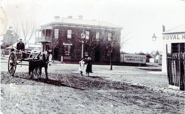
The photograph was taken at the intersection of Brook and Evans Streets in Sunbury. The two storey bluestone building was the Rupertswood Hotel, which was on the NE corner of the intersection and the single storey Royal Hotel building in the foreground was on the opposite corner. The Millett family originally owned both hotels. The Rupertswood Hotel was demolished in December 1974 to make way for a modern retail store. In 1939 the old Royal Hotel building was damaged by fire and replaced with a two storey red brick building.The Rupertswood and Royal Hotels were two of the earliest hotels to be erected in the Sunbury township.A non-digital black and white photograph of a street photograph featuring an intersection with a two storey bluestone building on one corner and a partial view of a single storey rendered building on the opposite corner. Two children are standing on the side of the road and a man is in a horse-drawn jinker. george millett, royal hotel, rupertswood hotel, evans street, brook street, hotels -
 Sunbury Family History and Heritage Society Inc.
Photograph, River studies
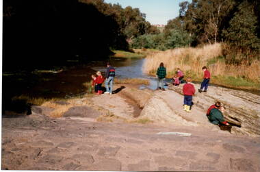
Students from Bulla Primary school were taken to the nearby Deep Creek to study some of the river life inn the local water course.Bulla township is situated in the Deep Creek valley and was an ideal place to take students to study river life close to their school.A coloured photograph of eight children with two adults standing on a rocky outcrop beside a river and looking at the riverlife in the water.rivers, deep creek, river studies, bulla, bulla primary school -
 Tarnagulla History Archive
Photocopy of historic map - Township of Llanelly, varied
David Gordon Collection. One photocopy in clear sleeve. -
Tarnagulla History Archive
Photocopies of historic maps - Township of Newbridge, varied
David Gordon Collection. Three photocopies in clear sleeve. -
Canterbury History Group
Map - Township of Canterbury and Township of Balwyn, 1900
Copies of the maps of Canterbuy and Balwyn copied and enlarged from Sands and Mcdougall Directory 1900canterbury, balwyn, sands and mcdougall directories -
 Bacchus Marsh & District Historical Society
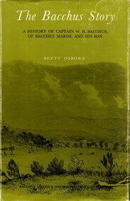
Book, The Bacchus Story: A History of Captain W. H. Bacchus of Bacchus Marsh and His Son, 1973
William Bacchus was one of the first European colonists to live in the township which was later named after him. He arrived in land occupied by the Wurundjeri and Wadawurrung peoples in 1838 and established a large sheep farm. He died in 1849 and his son Henry Bacchus continued his farming interests in the district until his death in 1887. This work is a biographical portrait of William and Henry Bacchus and of the early European occupation in the Bacchus Marsh district. PUBLICATION DETAILS: Bacchus Marsh, Vic., Bacchus Marsh and District Historical Society Inc., 1973:118 pages, 23 cm.non-fictionWilliam Bacchus was one of the first European colonists to live in the township which was later named after him. He arrived in land occupied by the Wurundjeri and Wadawurrung peoples in 1838 and established a large sheep farm. He died in 1849 and his son Henry Bacchus continued his farming interests in the district until his death in 1887. This work is a biographical portrait of William and Henry Bacchus and of the early European occupation in the Bacchus Marsh district. PUBLICATION DETAILS: Bacchus Marsh, Vic., Bacchus Marsh and District Historical Society Inc., 1973: william bacchus, bacchus family, henry bacchus, bacchus marsh, bmdhs publication -
 Bacchus Marsh & District Historical Society
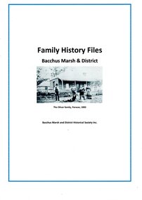
Document, Family History Files, Bacchus Marsh & District
Family History files relating to families and individuals from the township of Bacchus Marsh and its surrounding district. Files may contain family trees, replies to research inquiries, obituaries, biographical material, photocopies of published and unpublished material from books, newspapers, magazines, pamphlets, maps, archival sources and personal papers. Material may also include copies data from births, marriages, deaths, funeral, cemeteries and other genealogical registers and indexes. of Other material includes printouts of website pages, and photocopies or printouts of images. Arranged in A-Z sequence by family surname.Paper documents in ring and lever arch foldersFamily History files relating to families and individuals from the township of Bacchus Marsh and its surrounding district. Files may contain family trees, replies to research inquiries, obituaries, biographical material, photocopies of published and unpublished material from books, newspapers, magazines, pamphlets, maps, archival sources and personal papers. Material may also include copies data from births, marriages, deaths, funeral, cemeteries and other genealogical registers and indexes. of Other material includes printouts of website pages, and photocopies or printouts of images. Arranged in A-Z sequence by family surname.obituaries, funeral notices, death notices, births, marriages, cemetery records -
 Bacchus Marsh & District Historical Society
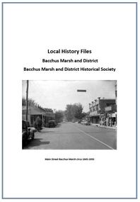
Local History Files Bacchus Marsh and District, 1969- to present
Local history subject files relating to the township of Bacchus Marsh and its surrounding district. Files may contain replies to research inquiries, photocopies of published and unpublished material from books, newspapers, magazines, pamphlets, maps, archival sources and personal papers.. Other material includes printouts of website pages, and photocopies or printouts of images. Material compiled by members of Bacchus Marsh and District Historical Society.Paper files in ring folders and lever arch folders. Arranged in A-Z sequence of topics.non-fictionLocal history subject files relating to the township of Bacchus Marsh and its surrounding district. Files may contain replies to research inquiries, photocopies of published and unpublished material from books, newspapers, magazines, pamphlets, maps, archival sources and personal papers.. Other material includes printouts of website pages, and photocopies or printouts of images. Material compiled by members of Bacchus Marsh and District Historical Society.local history, bacchus marsh -
 Phillip Island Conservation Society Inc.
Work on paper - Photocopy of newspaper cutting, "PHILLIP ISLAND/A place to fall in love"
This article was written by an English visitor named Elsa Christian who was touring Australia and New Zealand with her husband Frank in their own small van. The article was published in the Australian Women’s Weekly, magazine, March 1966. Elsa writes she wanted to visit four Australian locations before she died: Ayers Rock (actually Uluru), the Snowy River project, dolphins at Coolangatta and the Penguin Parade at Phillip Island. These destinations were all very popular in the 1960s for both Australian residents and overseas visitors. Because the roads were becoming better too many locations, self guided tours in small vans for cars towing bond would caravans were becoming more popular means of seeing AustraliaThe article is significant in many ways. 1. Indicates the places English visitors commonly wish to see in Australia. 2. Describes the growing trend to self- drive van/camping holidays. 3. Gives the route taken from Melbourne to Phillip Island during the 1960s. 4. Describes the appearance of the roadsides and locations visited. 5. It is written in a descriptive and lyrical style designed to appeal to Women’s Weekly magazine readers, who were probably wondering how they could visit Phillip Island with their husbands or families themselves, and what there was to see there. 6. Gives the visitors’ view of how the Penguin Parade operated at the time. 7. Includes a description of potter and artist Eric Juckert’s renowned garden at Grossard Point, Ventnor. 8. Indicates how introduced plants such as Hawthorn pushes and Kate weed were common in the area. 9. Describes Phillip Island as “a place to fall in love” because of its natural beauty, fauna and coastal seascapes. 10. As a visitor Elsa describes the housing estates as a blot on the landscape, but also sees the value as a way of their owners escaping from the hustle and bustle of Melbourne. 11. Gives the visitors’ interpretation of the behaviour of wildlife the RC in the wild, as well as Elsa’s knowledge about some of the species she encounters.Photocopy of full page article with 5 columns of text, a map and 2 photographs. Black ink on white paper. Photographs blackened in photocopying processphillip island, cape woolamai, penguin parade, seal rocks, nobbies, township of rhyll phillip island, princes highway, dandenong, pakenham, kooweerup, carinya creek, officer, san remo, gippsland highway, holiday homes, fort dumaresq, kitty miller's beach, wreck of the speke, hereford cattle, fleetwood manor, koalas, ventnor, eric juckert, little penguin behaviour -
 Wodonga & District Historical Society Inc
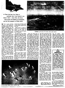
Booklet - The Vanished Village - Ebden Weir / Mitta Junction, Lyn Larkin, 2004
This publication tells the story of the village of Mitta Junction which was established in about 1920 on the Victorian side of the Hume Dam construction site. The town was built to house workers and their families during the construction of the Hume Weir. It included houses, a shop, hall and school as well as tennis courts. After the completion of the weir the village and all its contents was sold at auction in June 1936 for £7000. The Mitta Junction school continued to operate until the mid 1980s. The book also documents aspects of the history of the Clark family of Bonegilla.A small publication by a local author. A4 size including photographs and a map.This publication tells the story of the village of Mitta Junction which was established in about 1920 on the Victorian side of the Hume Dam construction site. The town was built to house workers and their families during the construction of the Hume Weir. It included houses, a shop, hall and school as well as tennis courts. After the completion of the weir the village and all its contents was sold at auction in June 1936 for £7000. The Mitta Junction school continued to operate until the mid 1980s. The book also documents aspects of the history of the Clark family of Bonegilla.mitta junction township, hume weir construction, clark family bonegilla -
 Wodonga & District Historical Society Inc
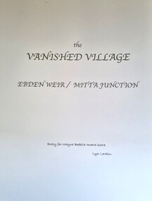
Functional object - Beehive Smoker c. early 1900s
Beehive smokers douse bees with smoke to calm them and make them less likely to sting while honey is extracted from beehives. They were invented in the mid nineteenth century, prior to which bees were killed in order to extract their honey. The invention of the bee smoker was an important innovation in the history of apiary. The Wodonga Historical Society beehive smoker appears to be of the same design as the patented Woodman’s Bingham Bee Smoker, produced from 1878 by T. F. Binghan of Albronia, Michigan. The Wodonga Historical Society beehive smoker is an important artefact connected to local history, and the history of apiary in Wodonga. Beekeeping was a popular pastime in the late nineteenth and early twentieth century, and apiaries were subject to regulation by the Wodonga Shire Council. At a 1914 meeting of the council, for instance, a by-law governing beekeeping in Wodonga was enacted after Mrs Smyth complained that Mr Bassett’s bees were swarming the watering holes in her paddocks and preventing livestock from drinking. There were areas within the Wodonga township where apiaries were prohibited, and Mr Bassett’s bees had fallen foul of the law. A canvas, wood and metal beesmoker from the early twentieth century. apiary, bees, beekeeping, honey, apiarists, wodonga, council, wodonga council, wodonga shire council, rural, livestock -
 Wodonga & District Historical Society Inc
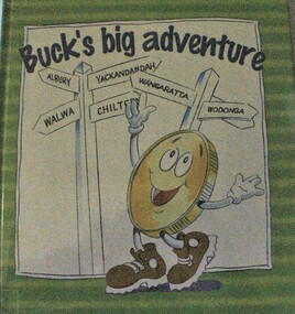
Book - Buck's Big Adventure, Ian Trevaskis & Emma Ashton, 2003
This book was produced by the WAW Credit Union with the aim of educating children about money and how it can take different forms as it is used throughout the community. It gives a message about how banking with a Credit Union impacts on the entire community. WAW Credit Union has been operating in various forms since 1956. The WAW stands for Wangaratta, Albury, Wodonga, reflecting its area and names of former credit unions from which it merged.A children's story book with large font text and colourful illustrations telling the story of a new dollar coin. It consists of 30 pages.fictionThis book was produced by the WAW Credit Union with the aim of educating children about money and how it can take different forms as it is used throughout the community. It gives a message about how banking with a Credit Union impacts on the entire community. WAW Credit Union has been operating in various forms since 1956. The WAW stands for Wangaratta, Albury, Wodonga, reflecting its area and names of former credit unions from which it merged.banks and banking - juvenile literature, waw credit union, credit union wodonga -
 Wodonga & District Historical Society Inc
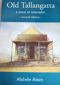
Book - Old Tallangatta : A town to remember 1850 - 1950, Malcolm Ronan, 2003
A history of the township of Tallangatta, Victoria which was moved in the 1950s due to the expansion of the Hume Damnon-fictionA history of the township of Tallangatta, Victoria which was moved in the 1950s due to the expansion of the Hume Damold tallangatta, tallangatta, hume dam, "the town that moved" -
 Wodonga & District Historical Society Inc
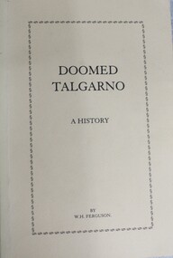
Book - Doomed Talgarno - A History, W. H. Ferguson, C. 1920 - 1929
A detailed study of the township of Talgarno in North Eastern Victoria, its geography and pioneering families. In the mid-1930s Talgarno’s river flats were inundated by the development of Lake Hume.non-fictionA detailed study of the township of Talgarno in North Eastern Victoria, its geography and pioneering families. In the mid-1930s Talgarno’s river flats were inundated by the development of Lake Hume.talgarno, pioneers north east victoria, lake hume -
 Wodonga & District Historical Society Inc
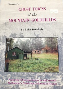
Book - Secrets of Ghost Towns of the Mountain Goldfields, Luke Steenhuis, 1999
Stories from 50 former towns in and around Melbourne's North-east mountain region. These old towns include: Aberfeldy, Aberfeldy Crossing, BB Township, Blue Jacket, Clarke's Flat, Concord Gully, Edwards Reef, Fultons Creek, Jericho, Loch Fyne, Red Jacket, Store Point, The Springs, Toombon, Toombon Upper, Tullamore, Upper Thomson, Victors Quartz, Violet Town & White Star.non-fictionStories from 50 former towns in and around Melbourne's North-east mountain region. These old towns include: Aberfeldy, Aberfeldy Crossing, BB Township, Blue Jacket, Clarke's Flat, Concord Gully, Edwards Reef, Fultons Creek, Jericho, Loch Fyne, Red Jacket, Store Point, The Springs, Toombon, Toombon Upper, Tullamore, Upper Thomson, Victors Quartz, Violet Town & White Star.ghost towns victoria, gold mining victoria -
 Buninyong & District Historical Society
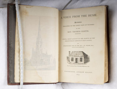
Book, Andrew Elliot, publisher, "A Voice from the Bush", Sermons by Rev. T. Hastie, Buninyong,1877, 1877
Book of sermons with an historical introduction to life in 1840s Port Phillip.Hardcover book of sermons preached in the early days of Victoria by the Rev. Thomas Hastie with a short account of the growth of the Presbyterian Church in that colony. Published by Andrew Elliot, Edinburgh, 1877, 386 pages.Book of sermons with an historical introduction to life in 1840s Port Phillip.thomas hastie, presbyterian church, buninyong -
 Sunbury Family History and Heritage Society Inc.
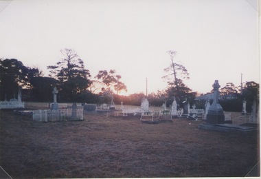
Photograph, Lydia Keyworth, Sunbury Cemetery, March 2001
The photograph of Sunbury Cemetery at sunset was entered into the Photograph Competition organised by the former Sunbury & District Heritage Association in March 2001.In 1862, land set aside in Cemetery Road for the Sunbury Cemetery was laid out in the following Christian denominational groups, Church of England, Roman Catholic, Baptist, Methodist, Presbyterian and Lutheran. Other non-denominational sites were set aside for paupers, heathens, Asians and pagans. Rebecca Jenkinson was the first person to be buried there in 1862. Over the years the size of the cemetery has expanded but it still occupies the original site off Shields Street in Sunbury and the names of the denominational divisions have changed over the years reflect a more inclusive outlook.Sunbury Cemetery replaced other smaller graveyards that were situated in some of the local church grounds and the earlier cemetery that was at The Gap township.A non-digital coloured photograph of a cemetery landscape with a number of old graves scattered across the open space. Some have small fences around them, while others simply display the headstones. There are trees in the background. sunbury cemetery, shields street, cemetery road, sunbury, cemeteries -
 Clunes Museum
Photograph
'PANORAMA' PHOTOGRAPH TAKEN FROM SMITH STREET, SHOWING LUFF'S HOUSE AND PART OF HILL STREET, ALSO VIEW OF CLUNES FROM HILL STREET SHOWING METHODIST CHURCH AND POST OFFICE.CLUNES FROM HILL STREET. ABOUT 1938 TO 1942photography, photographs, clunes township -
Clunes Museum
Book, GEOFF ARNOTT, REMEMBERING WEDDERBURN & NEIGHBOURING TOWNS
HISTORICAL RECOLLECTION OF WEDDERBURN AND SOUNDING TOWNSSOFT COVER BOOK, VARIOUSLY STREETSCAPE, RAILWAY STATION AND PUB IMAGES ON FRONT COVER, TOWN IN FOOD IMAGE ON BACK COVERnon-fictionHISTORICAL RECOLLECTION OF WEDDERBURN AND SOUNDING TOWNSwedderburn history, wedderburn townships -
 Lakes Entrance Historical Society
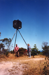
Photograph - Lakes Entrance Grid location, 1999
Lakes Entrance Grid reference, Cunninghame 8522.3.4 896.082, on ten acre site with trig point, it is from this point that all the survey for the surrounding areas was undertaken. Part of the Vic Geodetic Survey initiated in 1860 by Ellery Survey started from triangulation base in Werribee. (Grid ref B'dale 8422)Colour photograph of the Victoria Geodetic Survey Triangulation Station, Trig Station, situated off Ocean View Parade, Merrangbaur Hill. Location is indicated by ground point and standing structure, situated on an elevated bush block. Lakes Entrance Victoriasurveying, township planning -
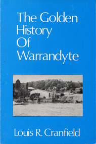 Surrey Hills Historical Society Collection
Book - The Golden History of Warrandyte, Louis R. Cranfield, 1982
This edition covers Warrandyte from the earliest days of the discovery of gold and the setting up of a mining camp - through its transition to become a thriving township attracting thousands of holiday visitors - is a factual survey of more than a hundred years of community life in Warrandyte, Victoria, Australia.an 18 cm book, 128p, includes 4 pics.non-fictionThis edition covers Warrandyte from the earliest days of the discovery of gold and the setting up of a mining camp - through its transition to become a thriving township attracting thousands of holiday visitors - is a factual survey of more than a hundred years of community life in Warrandyte, Victoria, Australia.gold mines and mining -- victoria -- warrandyte -- history, warrandyte -
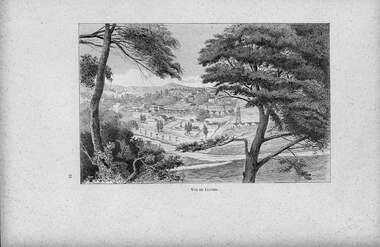 Clunes Museum
Artwork, other - ETCHING
BOUGHT ON EBAY FROM CATHERINE DUPRE, 8 RUE DE JUE D'ARC, 02300, GUIVRYCOPY OF ETCHING OF CLUNES - VUE DE CLUNESVUE DE CLUNESlocal history, illustration, etchings, clunes township, etching -
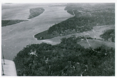 Lakes Entrance Historical Society
Photograph - Kalimna, Bulmer H D, 1940c
Black and white photograph of view over Kalimna, Maringa Creek, Saw Mill Flat, Fraser Island, Flannagan Island, aireal view. Lakes Entrance, Victoria.waterways, topography, townships -
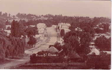 Clunes Museum
Photograph
SEPIA PHOTOGRAPH LOOKING DOWN TO FRASER STREET, CLUNESlocal history, photography, photographs, clunes township, fraser street. -
 Bacchus Marsh & District Historical Society
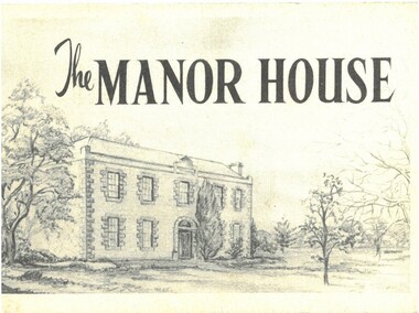
Pamphlet, The Manor House
This pamphlet outlines the early history of the house constructed for William Bacchus in 1846-1847 and briefly describes its condition as it was in 1957. William Bacchus was one of the first European colonists to live in the area in which a township (Bacchus Marsh) was later named after him. He arrived on land occupied by the Wurundjeri and Wadawurrung peoples in 1838 and established a large sheep farm. Between 1846 and 1847 he contracted builders and other skilled workers to construct a large brick and stone two storey house. William Bacchus died in 1849. His son Henry Bacchus sold the house in 1851. For many years it was owned by the Crook family. When this pamphlet was published in 1957 the house was owned by the Lifeguard Milk Company of Bacchus Marsh. By this time the property had become derelict and was almost demolished. Around this time the Young Mens Christian Association Club in Bacchus Marsh became involved in efforts to help preserve this historic property. This pamphlet was part of those efforts. PUBLICATION DETAILS: Y's Mens Club Bacchus Marsh, Bacchus Marsh, Vic., 1957. Text written by Ronald G. Westood.Small pamphlet. Stapled softcover. 23 unnumbered pages. 11cm x 16cm. Contains photographs and cover illustration. BMDHS Location: AR/SU5 Pamphlets Box 4.non-fictionThis pamphlet outlines the early history of the house constructed for William Bacchus in 1846-1847 and briefly describes its condition as it was in 1957. William Bacchus was one of the first European colonists to live in the area in which a township (Bacchus Marsh) was later named after him. He arrived on land occupied by the Wurundjeri and Wadawurrung peoples in 1838 and established a large sheep farm. Between 1846 and 1847 he contracted builders and other skilled workers to construct a large brick and stone two storey house. William Bacchus died in 1849. His son Henry Bacchus sold the house in 1851. For many years it was owned by the Crook family. When this pamphlet was published in 1957 the house was owned by the Lifeguard Milk Company of Bacchus Marsh. By this time the property had become derelict and was almost demolished. Around this time the Young Mens Christian Association Club in Bacchus Marsh became involved in efforts to help preserve this historic property. This pamphlet was part of those efforts. PUBLICATION DETAILS: Y's Mens Club Bacchus Marsh, Bacchus Marsh, Vic., 1957. Text written by Ronald G. Westood. william bacchus, bacchus family, henry bacchus, bacchus marsh, manor house bacchus marsh, houses bacchus marsh, historic buildings bacchus marsh -
 Clunes Museum
Photograph
BLOWN UP PHOTO OF VIEW OVER LOOKING FRASER ST. FROM "THE ROCKS". NOTE 2 CHURCHES - ONE C OF E, LATER MOVED TO PRESENT SITE, NEXT TO BLUE STONE ST. PAUL'S. CLUB HOTEL ON LEFT. "METHODIST CHURCH WITHOUT SPIRE AND MARKET NEXT ON PRESENT POLICE STATION PADDOCK OPPOSITE THE METHODIST CHURCH (THEN WESLEYAN) IS THE OLD CEMETERY AND THERE ARE WHITE FORMS LIKE TOMBSTONES SHOWING.BLACK AND WHITE PHOTOGRAPH OF VERY EARLY CLUNES - BUILDINGS, CHURCHES, HOUSESPRIMITIVE METHODIST CHURCH IN HILL ST.local history, photography, photographs, clunes township