Showing 13591 items
matching wye-river-bridge
-
 Phillip Island and District Historical Society Inc.
Photograph - Post Card, 1940's
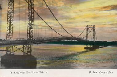
One of 11 photographs left in the museum for the Society by an anonymous donor.Colour postcard of the old Suspension Bridge from San Remo to Newhaven at sunset.Sunset over San Remo Bridge (Bulmer copyright)phillip island suspension bridge, sunset at san remo -
 Port Melbourne Historical & Preservation Society
Photograph - Station Hotel, corner Bridge and Station Streets, Port Melbourne, c. 1950
Black & white photograph of the Station Hotel with Railway reserve & Bridge Street in the foreground.On reverse ' Station Hotel Cnr Bridge & Station Streets'business and traders - hotels, built environment - commercial, built environment - domestic, station hotel -
 Federation University Historical Collection
Photograph, Two black and white photographs at Wentworth
Jack (John R) Watson and Herb (Ernest Herbert) Smith at Wentworth..1 Bridge at Wentworth .2 Loch at Wentworth.1 verso - Bridge at Wentworth .2 verso - Loch at Wentworth Herb and Jackwentworth, bridge - wentworth, loch - wentworth -
 Phillip Island and District Historical Society Inc.
Photograph, 1940's - 1950's
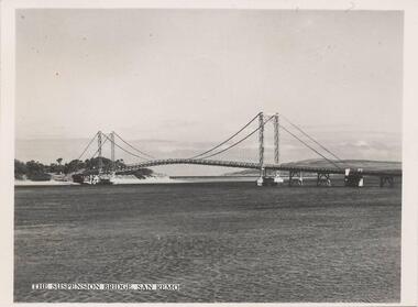
One of a collection of 9 photographs donated by the former Shire of Phillip Island. This photo was part of a pack of postcards sold to the tourists/visitors to Phillip Island.Black & White photograph of view eastward from Cleeland Bight of the Phillip Island/San Remo Suspension Bridge. The photo is part of a set."The Suspension Bridge San Remo"suspension bridge san remo/phillip island, phillip island suspension bridge, bridges, shire of phillip island -
 Tatura Irrigation & Wartime Camps Museum
Photograph, Clark D, 1989
Waranga Basin commenced in 1902Black and white photograph of Waranga - Mallee channel, flowing under bridge on Tatura - Rushworth road.on back - Bridge over Waranga - Mallee channelwaranga basin -
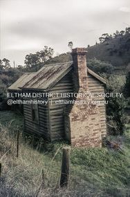 Eltham District Historical Society Inc
Slide, Pills Cottage, Heidelberg-Kinglake Road, Cottles Bridge, Vic, c.1970
Pills Cottage about halfway from Cottles Bridge to St Andrews near 1575 Heidelberg-Kinglake Road, St Andrews. William John "Bill" Pill was born on 19th June 1894 at Diamond Creek He was brutally murdered on 21st December 1958 age 64, in his cottage. His father was John Henry Pill, born 24 November 1856, Lalone, Perranzabuloe, Cornwall, England, He died 21 December 1930 at Cottles Bridge, His mother was Jessie Ann Whatmough, born 6th June 1870. She died 21 August 1921. William John "Bill '' Pill, grew tomatoes on his rich two and a half acres. In 2024 his second cousin Steve Whatmough recalled visiting Bill in 1957 with his parents (Eric and Nancy Whatmough) and Bill showing them his tomatoes. He had a very large aeroplane propeller set up at one end on his tomato crop. He would run the propeller on frosty mornings to keep away the frost damage. His tomatoes would ripen early and would receive a premium price for them. The cottage consisted of two buildings. The one closest in the right side of the photo was the kitchen. The second building that also has a chimney was his bedroom and living room.35 mm colour positive transparency Mount - Agfacolor Service (Blue)heidelberg-kinglake road, pills cottage, st andrews, william john pill, bill pill, john henry pill, jessie ann pill (nee whatmough), market gardener, murder, cottles bridge (vic.), tomato farm, mount - agfacolor service (blue), scan - 35mm positive -
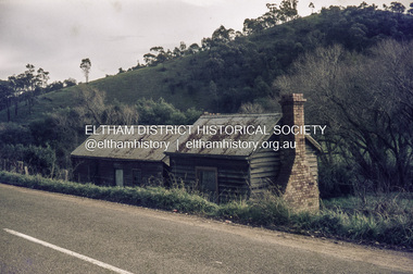 Eltham District Historical Society Inc
Slide, Pills Cottage, Heidelberg-Kinglake Road, Cottles Bridge, Vic, c.1970
Pills Cottage about halfway from Cottles Bridge to St Andrews near 1575 Heidelberg-Kinglake Road, St Andrews. William John "Bill" Pill was born on 19th June 1894 at Diamond Creek He was brutally murdered on 21st December 1958 age 64, in his cottage. His father was John Henry Pill, born 24 November 1856, Lalone, Perranzabuloe, Cornwall, England, He died 21 December 1930 at Cottles Bridge, His mother was Jessie Ann Whatmough, born 6th June 1870. She died 21 August 1921. William John "Bill '' Pill, grew tomatoes on his rich two and a half acres. In 2024 his second cousin Steve Whatmough recalled visiting Bill in 1957 with his parents (Eric and Nancy Whatmough) and Bill showing them his tomatoes. He had a very large aeroplane propeller set up at one end on his tomato crop. He would run the propeller on frosty mornings to keep away the frost damage. His tomatoes would ripen early and would receive a premium price for them. The cottage consisted of two buildings. The one closest in the right side of the photo was the kitchen. The second building that also has a chimney was his bedroom and living room.35 mm colour positive transparency Mount - Agfacolor Service (Blue)bill pill, cottles bridge (vic.), heidelberg-kinglake road, jessie ann pill (nee whatmough), john henry pill, market gardener, mount - agfacolor service (blue), murder, pills cottage, scan - 35mm positive, st andrews, tomato farm, william john pill -
 Eltham District Historical Society Inc
Negative - Photograph, The Bridge, Hurstbridge, Vic, c.1925
Copied from brochure "Wattle Valley Estate" 7 minutes from the bridge. The new bridge designed by Sir John Monash over the Diamond Creek near Hurst's home of 'Mia Mia' at Hurstbridge. The Wattle Valley Estate was first advertised in August 1925 as weekend building allotments by the Greater Melbourne Land and Development Company. Advertised from £28.10.0 or £60 per block. In August 1926, 30 picked allotments of 60x150 feet were put up for auction Saturday August 14, 1926 with frontages to Valley View Road and Fawkner Crescent advertised in the “Heart of the Glorious Wattle Country” and “Within 15 Minutes of the Newly Electrified Railway Station”. The Advertiser on August 13, 1926 in an article promoting the auction stated “the estate is regarded as one of the best in the district, and will be sold practically without reserve.” It is noted that an advertisement running in The Argus February 22, 1951 offered the remaining 16 blocks for sale at £12.10.0 or £200 the lot. By March 7, the remaining blocks were advertised at £17.10.0 The Wattle Valley Estate took over 20 years to sell and then people could not build on them This image was also used in a brochure advertising the "Wattle Valley Estate", which forms part of the Shire of Eltham Pioneers Photograph Collection (Cross Reference Photo No.(s): 1056, 1057)This photo forms part of a collection of photographs gathered by the Shire of Eltham for their centenary project book,"Pioneers and Painters: 100 years of the Shire of Eltham" by Alan Marshall (1971). The collection of over 500 images is held in partnership between Eltham District Historical Society and Yarra Plenty Regional Library (Eltham Library) and is now formally known as the 'The Shire of Eltham Pioneers Photograph Collection.' It is significant in being the first community sourced collection representing the places and people of the Shire's first one hundred years.Digital image 4 x 5 inch B&W Negshire of eltham pioneers photograph collection, hurstbridge, bridge, diamond creek (creek), monash bridge, wattle valley estate -
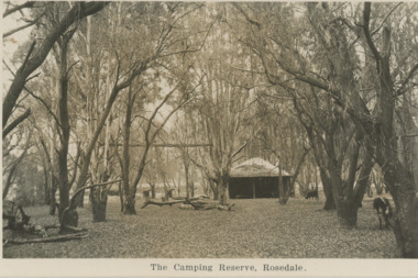 Lakes Entrance Historical Society
Postcard, Camping Reserve Rosedale, 1940 c
Also a black and white postcard of highway bridge over the Latrobe River Rosedale 05412.1 9 x 14 cmBlack and white postcard of camping reserve showing picnic shelter and two fire places set in timbered area and glimpses of highway bridge through trees Rosedale VictoriaThe Camping Reserve Rosedalecamping, bridges -
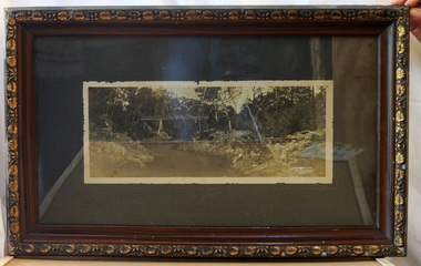 Orbost & District Historical Society
framed black and white photograph, C1920
Boggy Creek Bridge was built in 1916 as part of the Bairnsdale to Orbost extension to the main Gippsland Railway, and is situated in the middle of the township of Nowa Nowa, crossing a steep-sided and well-timbered creek-valley. This section of the line closed in 1987. This item is a pictorial record of the Boggy Creek railway bridge on the East Gippsland line. This bridge plays a major part in the identity and history of the town of Nowa Nowa, since Boggy Creek’s steep sided valley divides the township into two components.A black / white photograph of a bridge across a river in the bush. It is under glass in a brown wooden frame which has gold decorated edges. There appears to be a man sitting on rocks in the right front foreground.on front of photograph - "Nowa Nowa Creek, Gippsland, Victoria, Sears, Copyright"boggy-creek-nowa-nowa east-gippsland-railway bridge-rail -
 Eltham District Historical Society Inc
Negative - Photograph, Tom Prior, Railway Trestle Bridge over the Diamond Creek, Eltham, Vic, c.1910
Railway Trestle Bridge over the Diamond Creek, Eltham, c.1910 - looking towards Main Road (left to right) and Henry Street (centre). Built in 1901, the railway line was electrified in 1923. Photo was taken prior to 1912 and the relocation of the new St Mary’s Catholic Church on Henry Street near Main Road (or Maria Street). The church site was relocated c.1912 from further south along Main Road (near Wingrove Cottage) to be more central to the congregation following the shifting of the township away from Little Eltham and closer to the railway station. It was subsequently destroyed by fire in 1961.This photo forms part of a collection of photographs gathered by the Shire of Eltham for their centenary project book,"Pioneers and Painters: 100 years of the Shire of Eltham" by Alan Marshall (1971). The collection of over 500 images is held in partnership between Eltham District Historical Society and Yarra Plenty Regional Library (Eltham Library) and is now formally known as the 'The Shire of Eltham Pioneers Photograph Collection.' It is significant in being the first community sourced collection representing the places and people of the Shire's first one hundred years. The Reynolds family were early settlers in Research. The Reynolds/ Prior collection of photographs were taken by Tom Prior, the maternal uncle of Ivy Reynolds, around 1900 and the 60 photos in the album give a fine overview of many of the landmarks of Research and Eltham over 100 years ago. lvy lived in the family home for many years at 106 Thompson Cres Research. Ivy's father, Ernst Richard Reynolds and grandfather, Richard Reynolds, lived at the same address. Ivy's father Richard worked for Mr. Trail on his property in Research. Reynolds Road is named after the family. Mr Tom Prior (wife Eva) worked at the Melbourne zoo. He was very innovative and made his own camera, using the black cloth hood to exclude the light. The photographs are a reminder of the rural nature of Research and Eltham and its rich heritage.Digital image 4 x 5 inch B&W Negshire of eltham pioneers photograph collection, bridge, diamond creek (creek), eltham, eltham railway trestle bridge, henry street, main road, reynolds prior collection, trestle bridge -
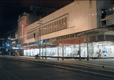 City of Ballarat Libraries
35mm Slide, Morshead's Department Store, Bridge Street Ballarat, circa 1950s
Morshead's was a popular department store in the 1950s and 1960s. In this night exposure the famous window displays can be clearly seen. Also at the extreme right of the photograph the verandah over 'the bridge' can be seen - the creek is covered over making an arcade. Also the verandah posts which were all removed in the 1960s and cantilevered verandahs installed throughout Ballarat. Mrs Bon Strange and her husband Bert were well known Ballarat residents. When Mrs Strange died some years ago, her extensive slide collection was sorted through and those relevant to Ballarat were gifted to the Ballarat Library. bridge street, department store, trams, illuminations, shop windows, advertising -
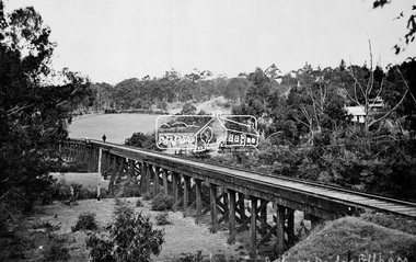
 Phillip Island and District Historical Society Inc.
Photograph, Phillip Island Bridges, 1968/9
Shows first Bridge carrying traffic with 1969 Bridge just being constructed. From the Jack Jenner CollectionOld suspension Bridge with New Bridge appearing in background. Speed Boat middle foreground. local history, photographs, civil engineering, bridges, phillip island bridge, black & white photograph, jack jenner collection, phillip island bridges, public construction -
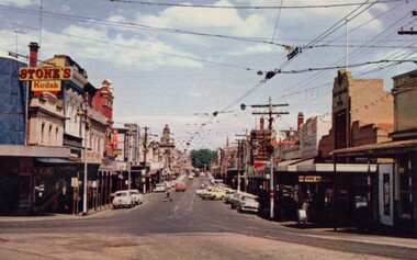 Ballarat Tramway Museum
Photograph - Digital Image, Bridge Street
Yields information about the appearance of Bridge St early 1960's and the buildings on either side. Shows the festoon lighting.Digital Copy of a photograph sourced by Roger Greenwood as part of his work on the production of a Video Tape on Ballarat's trams. Photographer and source details not provided by Roger. See btm6304doc.pdf Image looking west along Bridge St Ballarat with the festoon lighting in position. See Reg Item 6303i. This image appears to be early 1960's, possibly a bogie tram with yellow stripping at the Grenville St end, but not the large white stripe. Has the Stones Corner and The State Bank buildings in the view. Photo from a postcard, published c1967 as advised in the e-mail of 20/7/15. Print in box 13 trams, tramways, bridge st, stones corner, main road -
![Photograph - Construction of the F19 [Eastern Freeway], Ron Setford, ca. 1973](/media/collectors/550653872162f11fb04854aa/items/6804bf9ce716c23079f56c8e/item-media/6804bfc2e716c23079f56eab/item-fit-380x285.jpg) Kew Historical Society Inc
Kew Historical Society IncPhotograph - Construction of the F19 [Eastern Freeway], Ron Setford, ca. 1973
Ron Setford and his wife Grace Setford lived in Tanner Avenue, East Kew, from c.1946 to c.1995. A keen photographer, he recorded the changing face of Kew over a 20 year period. Apart from 30 photographs of built structures and places in Kew dating from 1960 and 1961, 145 of his 35mm colour slides chronicle the development of the F19 (later renamed Eastern) Freeway through the Yarra Valley in Kew over a five year period from c.1972 to c.1977. This important collection was donated to the Society by his granddaughter in 2025.This collection of 175 35mm slides is of local and statewide significance, owing to its subject matter, particularly the major development of road transport infrastructure during the 1970s with the construction of the Eastern Freeway. The photographer also took care to annotate and date most of his slides which enable the researcher to pinpoint temporal and spatial locations."Eastern Freeway / Bridge over river Fairfield - Kew / Hornibrook contractor"ron setford, eastern freeway, f19 freeway -
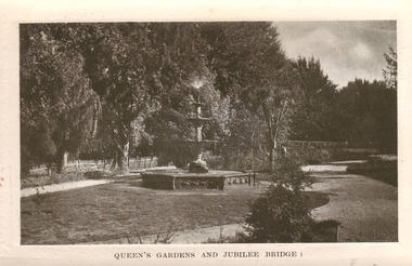 Clunes Museum
Photograph
CLUNES QUEEN'S PARK GARDEN'S.1 ORIGINAL POSTCARD OF CLUNES QUEEN'S GARDEN. FOUNTAIN IN THE FOREGROUND. JUBILEE BRIDGE IN THE BACKGROUND .2 PHOTOCOPY OF POSTCARD .3 ENLARGED PHOTOCOPY OF POSTCARDQUEEN'S GARDENS AND JUBILEE BRIDGE.postcard, queen's park garden -
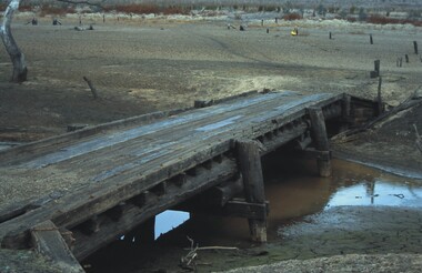 Bendigo Historical Society Inc.
Slide - VAL DENSWORTH COLLECTION: DRY LAKE EPPALOCK, May 2004
Slide. Dry Lake Eppalock. A Small wooden bridge over the river in the Lake.slide, bendigo, dry lake eppalock., dry lake eppalock. -
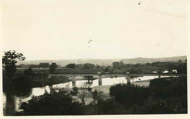 Lakes Entrance Historical Society
Photograph - Bridges, 1924
February 1924 date made.Black and white photograph of the railway bridge over the Tambo River at Bruthen, Victoria.bridges, waterways -
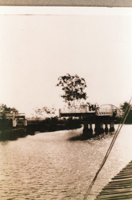 Lakes Entrance Historical Society
Photograph, 1925
Sepia photograph showing swing bridge open, on Latrobe River, at Longford, Victoriabridges, waterways -
 The Beechworth Burke Museum Research Collection
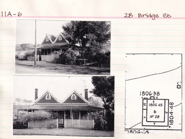
Card (Series) - Index Card, George Tibbits, 28 Bridge Street, Beechworth, 1976
George Tibbits, University of Melbourne. Faculty of Architecture, Building and Town & Regional PlanningIndex system that support the research for Beechworth : historical reconstruction / [by] George Tibbits ... [et al]Arranged by street names of BeechworthEach index card includes: street name and number of property, image of property, allotment and section number, property owners and dates of ownership, description of the property according to rate records, property floor plan with dimensions.beechworth, george tibbitsbeechworth, george tibbits -
 Orbost & District Historical Society
black and white photograph, June 1897
This photograph was taken at what is now the Young’s Creek picnic area which is located on the site of an old sawmill, once owned and operated by L.E. & H. Williams, dating back to the early 1920’s. The mill was eventually sold, dismantled, and the machinery transferred to a sawmill at Cabbage Tree Creek. there are still some items of old sawmill debris. The old steam engine at the edge of the car park is the remains of the mill’s former power plant. This portable steam engine was constructed in Leiston, Suffolk, in England.This is a pictorial record of a popular recreational area in the Orbost district in the late 19th century.A black / white photograph of a wooden bridge over a creek in forest setting. There is a second copy.on back - handwritten "the Young's Creek Bridge June 1897"young's-creek-orbost bridge-young's-creek -
 Phillip Island and District Historical Society Inc.
Photograph - Post Card, A. J. Murray, c 1950
Postcard donated by Brenda HumphreysBlack & White postcard of the Phillip Island Suspension Bridge main span taken from San RemoPhoto Shop Series Phillip Island Bridge.suspention bridge, phillip island suspention bridge, brenda humphreys -
Lakes Entrance Historical Society
Photograph - Buchan River, M D Fish, 1/09/1933 12:00:00 AM
Permission required from LERHS for copyingBlack and white photopgraph of Buchan River below the bridge. Young Rex Fish on bank of river with small white building Buchan Victoriawaterways -
 Kew Historical Society Inc
Postcard - Fishing, Yarra River, Henry Beater Christian, 1920s
Henry Christian (c.1809-91), the grandfather of the photographer, was one of the first settlers in Kew. He arrived in Victoria with his wife Agnes and son Orlando in 1855 on the Gypsy Queen. He established a rope-making business in Bulleen Road by 1858 but was declared insolvent two years later. In his final years, he was celebrated as one of the oldest living settlers of the district. His son, Orlando Henry Beater Christian (c.1853-1930) became a member of the Hawthorn Band and a foundation member of the Willsmere Swimming Club. Orlando and his wife Elizabeth had four children of which Henry Beater Christian (1886-1962) was the eldest.A photograph by Henry Beater Christian (1886-1962) of Pakington Street, Kew. Henry Beater Christian, was a keen explorer, not just of his immediate environment but also of the Victorian wilderness. His major opus is contained in two albums in which he records, sometimes in majestic detail and on other occasions the intimate features of the natural world. His photographic travels during the 1920s, often in solitary ramblings but on other occasions with companions, recall the heroic landscape photography of an earlier era, pioneered by Nicholas Caire. In addition to their aesthetic value, the albums are historically significant records within the State of Victoria, of what is now a distant point in time, and of places that have become radically altered through human intervention.Sepia 'real photo' postcard of Orlando Henry Beater Christian, fishing in the Yarra River. There appear to be cattle in paddocks on the other side of the river. Fairfield (sic) is on the horizon."Henry Beater's photograph of his father Orlando Henry Beater Christian whilst fishing in the River Yarra, Kew"yarra river -- kew (vic.), orlando beater christian, christian-washfold collection -
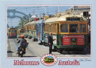 Melbourne Tram Museum
Postcard, Steve Parish Paddington Qld, Prince's Bridge, late 1980's
Colour postcard grey border, divided back - Steve Parish postcard of 7 trams on Prince's Bridge, with a blue arch in the background. The lead tram - W5 or SW5 793 showing route 3, followed by many trams. On the other track appears to be SW5 872, route 15. Both have Medibank Private adverts on the front. May have been at the time of an event, given that a Officer in a suit is talking to the driver. Back has space for name and address, stamp and a message and details of the postcard. Produced by Steve Parish Postcards. Card No. PC3029 and a historical note regarding trams on the back. Has "Melbourne Australia" along the bottom edge.trams, tramways, princes bridge, sw5 class, route 3, route 15, tram 793, tram 872? -
 Kew Historical Society Inc
Photograph - Zig-zag Bridge, Kew, Henry Beater Christian, 1920s
An item from an outstanding and diverse photographic collection, assembled by members of the Christian family of Pakington Street, Kew, comprising professional and amateur photography, depicting individuals, natural and settled environments and the interactions between these worlds. Many of the photographs vividly capture the worlds of three generations of men - Henry Christian, his son Orlando Henry Beater Christian, and his grandson of Henry Beater Christian. The most important photographer was the youngest, Henry Christian, who was a keen explorer, not just of his immediate environment but also of the Victorian wilderness. His major opus is contained in two albums in which he records, sometimes in majestic detail and on other occasions the intimate features of the natural world. His photographic travels during the 1920s, often in solitary ramblings but on other occasions with companions, recall the heroic landscape photography of an earlier era, pioneered by Nicholas Caire. In addition to their aesthetic value, the albums are historically significant records within the State of Victoria, of what is now a distant point in time, and of places that have become radically altered through human intervention.Sepia photograph of the wooden trestle Zig-Zag Bridge across the River Yarra. The bridge was built in the 1870s to transport stone from the west side of the Yarra to the east side. The stone was used in the construction of the Kew Asylum. The bridge continued to link the two asylums on each side of the river. yarra river -- kew (vic), zig-zag bridge -- kew (vic.), henry beater christian, christian-washfold collection -
 Hume City Civic Collection
Photograph, late 1970s
The photograph was taken before the wooden Holden Bridge which spans an arm of the Deep Creek at Bulla was replaced by a more sunstantial concrete structure. As well as building a new bridge, the sharp bend and approach to the old bridge was also removed.A black and white photograph of a wooden road bridge with eucalypt trees growing on either side of the bridge.bridges, holden bridge, shire of bulla, george evans collection -
 Eltham District Historical Society Inc
Negative - Photograph, Tom Prior, Langlands Bridge, Eltham, c.1900
It is noted in the Reynolds Prior collection (Ivy Reynolds) as the first bridge in Eltham however given the current state of knowledge, this is considered unlikely and there is no other supporting source. John Hunter Langlands, owner of the farm known as ‘Ihurst’ on the west side of Diamond Creek to the south of John Wright Murray’s land, died in 1907. In 1909 his land was subdivided into 100 lots to become the ‘Glen Park Estate’. It is possible that the bidge may have crossed the Diamond Creek to Langland's land along the original alignment of Glen Park Road which used to run between present day Progress Road and Coleman Crescent. SEPP Source (c.1970): Mrs. E.R. Reynolds, Thompson Crescent, Research The Reynolds family were early settlers in Research. The Reynolds/ Prior collection of photographs were taken by Tom Prior, the maternal uncle of Ivy Reynolds, around 1900 and the 60 photos in the album give a fine overview of many of the landmarks of Research and Eltham over 100 years ago. lvy lived in the family home for many years at 106 Thompson Cres Research. Ivy's father, Ernst Richard Reynolds and grandfather, Richard Reynolds, lived at the same address. Ivy's father Richard worked for Mr. Trail on his property in Research. Reynolds Road is named after the family. Mr Tom Prior (wife Eva) worked at the Melbourne zoo. He was very innovative and made his own camera, using the black cloth hood to exclude the light. The photographs are a reminder of the rural nature of Research and Eltham and its rich heritage. This photo forms part of a collection of photographs gathered by the Shire of Eltham for their centenary project book,"Pioneers and Painters: 100 years of the Shire of Eltham" by Alan Marshall (1971). The collection of over 500 images is held in partnership between Eltham District Historical Society and Yarra Plenty Regional Library (Eltham Library) and is now formally known as the 'The Shire of Eltham Pioneers Photograph Collection.' It is significant in being the first community sourced collection representing the places and people of the Shire's first one hundred years.Digital image 4 x 5 inch B&W Neg B&W printsepp, shire of eltham pioneers photograph collection, eltham, langlands bridge, reynolds prior collection, bridge, john hunter langlands -
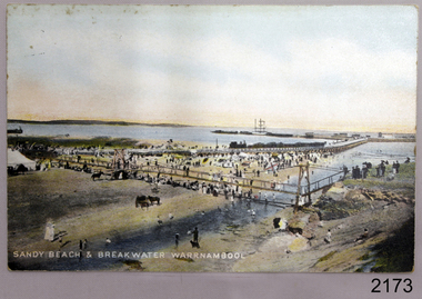 Flagstaff Hill Maritime Museum and Village
Postcard - Coastal Scene, Joseph Jordan, Sandy beach & breakwater Warrnambool, 1910
The coloured postcard depicts the Port of Warrnambool in the early 1900s. It shows the Breakwater, completed in 1890, the Viaduct, and the Merri River footbridge. There are many people on the sandy river banks, beach and bridge, and some are on the rocks of Middle Island. The printed postcard was made in England and is one of the Jordan Series produced by Joseph Jordan, a renowned photographer in Victoria's Western District.The postcard is locally significant as a record of the early footbridge over the Merri River, and the Viaduct before the space between the pylons was filled it. It shows the use of horses as a means of transportation. The photograph is also associated with Joseph Jordan, a renowned Victoria's Western District photographer.Postcard, coloured, showing the Port of Warrnambool. People are gathered on the sandy beach beside the river and near the river mouth. They are on and below the footbridge, along with several horses. Some are on the rocky Middle Island. There is a white ship in port. There is a jetty on the left, and buildings at the start of the breakwater. An inscription is printed at the bottom of the picture. The picture is one of the Jordan Series. It was printed in England in 1910."SANDY BEACH & BREAKWATER AT WARRNAMBOOL" "JORDAN SERIES" "PRINTED IN ENGLAND" "1910"warrnambool, shipwreck coast, flagstaff hill, flagstaff hill maritime museum, flagstaff hill maritime village, postcard, merri river, footbridge, warrnambool breakwater, breakwater, viaduct, middle island, port of warrnambool, jordan series, printed in england, 1910, joseph jordan, jordan photography -
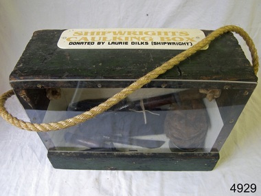 Flagstaff Hill Maritime Museum and Village
Equipment - Toolbox, Laurie Dilks, shipwright, Mid-to-late 20th century
Caulking is a process used by shipwrights and other tradespeople to seal the gaps and cracks in boats and ships, buildings and plumbing fittings. It prevents water, air and pests from entering the through the gaps. The shipwright’s caulking box and a display of shipwright's tools are connected to the maritime history of Victoria through their past owner, user and donor, Laurie Dilks. Laurie began his career as a shipwright in the mid-1900s, following in the wake of the skilled carpenters who have over many centuries used their craft to build and maintain marine vessels and their fittings. Laurie worked for Ports and Harbours, Melbourne, for over 50 years, beginning in the early 1960s. He and a fellow shipwright inscribed their names on a wheelhouse they built in 1965; the inscription was discovered many decades later during a repair of the plumbing. Many decades later Laurie worked on the Yarra River moving barges up and down the river and was fondly given the title ‘Riverboat Man’ His interest in maritime history led him to volunteer with the Maritime Trust of Australia’s project to restore and preserve the historic WWII 1942 Corvette, the minesweeper HMAS Castlemaine, which is a sister ship to the HMAS Warrnambool J202.The shipwright’s caulking box containing caulking tools is an example of the equipment used by shipwrights in the early to mid-20th centuries. This box is connected to the maritime history of Victoria through its past owner, user and donor, Laurie Dilks. Laurie began his career as a shipwright at Ports and Harbours in Melbourne in the mid-1900s, following in the wake of the skilled carpenters who have over many centuries used their craft to build and maintain marine vessels and their fittings.Shipwright's caulking box, green wooden exterior with green and cream interior. Box has a Perspex face. A rope handle, knotted on each end, extends from one side to the other. A white rectangular plaque with rounded corners is screwed to the top and has yellow and black printed text. The donor was shipwright Laurie Dilks.Printed on plaque "SHIPWRIGHTS / CAULKING BOX / DONATED BY LAURIE DILKS [SHIPWRIGHT]'"flagstaff hill, flagstaff hill maritime museum and village, warrnambool, maritime museum, maritime village, great ocean road, shipwreck coast, caulking tools, caulking equipment, caulking box, shipwright's tools, laurie kilks, ports and harbours