Showing 515 items matching " big hill."
-
 Bendigo Historical Society Inc.
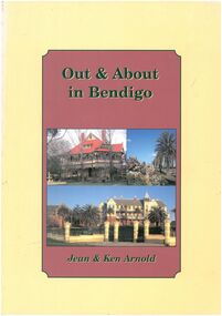
Book - Out & About in Bendigo
... , Mandurang , Big Hill, Maiden Gully and around Eaglehawk... , Big Hill, Maiden Gully and around Eaglehawk Black and White ...Historical markers plaques stones tabulets and photos from an area covering Huntly across to Junortoun to Strathfieldsaye , Mandurang , Big Hill, Maiden Gully and around EaglehawkOut & About in Bendigo - Jean & Ken Arnold Cream outer edge with plum coloured insert with black writing. Front cover Photo Langley Hall Botanical gardens and former Orphanage building Back cover various photos. Pages 80. black and white photos, maps -
 Bendigo Historical Society Inc.
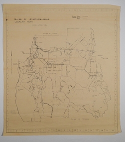
Map - CAMPBELL COLLECTION: BENDIGO AND DISTRICT MAPS, 21-8-1972
... Railway Line, Big Hill Tunnel, Mt.Herbert 1596.Axedale Township... roads. Melbourne to Bendigo Railway Line, Big Hill Tunnel ...Map. Shire of Strathfieldsaye, Locality Plan. Scale I inch=1 mile. Shire of Huntly, Shire of McIvor, City of Bendigo, Shire of Marong, Shire of Maldon, Shire of Metcalfe. Lake Eppalock. Mileage markers on some roads. Melbourne to Bendigo Railway Line, Big Hill Tunnel, Mt.Herbert 1596.Axedale Township, Strathfieldsaye Township.M.Higgs 21-8-1972map, bendigo, locality plan -
 Stawell Historical Society Inc
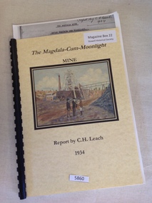
Book, C.H. Leach, The Magdala-Cum-Moonlight Mine, 1934
... portion, underlying the southern extremity of the big Hill. Report... portion, underlying the southern extremity of the big Hill. Report ...The Report is intended to summarise and place on record the information recently collected regarding the Magdal Lode, with the object of correlating the Northern, or more extensive developed portion, underlying the southern extremity of the big Hill. Report by C.H. LeachYellow card front and rear cover. front cover has a Picture by Ian Hollwell of three men standing in front of a Poppet head and chimneyThe Magadala-Cum-Moonlight Report by C.H. Leachstawell gold mining -
 Bendigo Historical Society Inc.
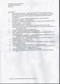
Document - MCCOLL, RANKIN AND STANISTREET COLLECTION: GOLDEN CARSHALTON NO LIABILITY, 1934-1960
... , Lease Agreement, Name change from Big Hill North N.L., Lease... deposit for PMG charges, Lease Agreement, Name change from Big ...Documents; Bundle of documents tied with string, Cert of Inspection for Boiler, Electricity Agreement, Scrip Certificates, Commonwealth Bank Pass Book for (pounds)10 deposit for PMG charges, Lease Agreement, Name change from Big Hill North N.L., Lease agreement Tennant Creek, Insurance documents, Rules. Legal Opinion Document. Golden Carshalton N.L.MCCOLL RANKIN & STANISTREETorganization, business, golden carshalton nl, mccoll rankin & stanistreet -
 Bendigo Historical Society Inc.
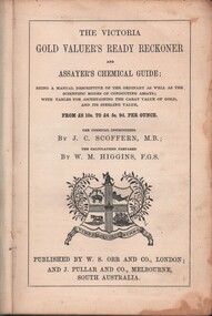
Book - MCCOLL, RANKIN AND STANISTREET COLLECTION: THE VICTORIA GOLD VALUERS READY RECKONER, 1853
... ) Spine missing. Inside front cover stamped Big Hill Mining... stamped Big Hill Mining Company. Book MCCOLL, RANKIN ...Book; Cloth bound hard cover book - 'The Victoria Gold Valuer's Ready Reckoner and Assayers chemical guide'. Being a manual descriptive of the ordinary as well as the scientific modes of conducting assays; with tables for ascertaining the carat value of gold audits sterling value (Scoffern & Higgins) Spine missing. Inside front cover stamped Big Hill Mining Company.MCCOLL RANKIN & STANISTREETgold mining, miners' safety cage, gold valuers ready rreckoner, mccoll rankin & stanistreet -
 Tarnagulla History Archive
Photographs: The Newbridge Rifle Club (The Bendigonian), The Newbridge Rifle Club (The Bendigonian), October 22, 1901 (original)
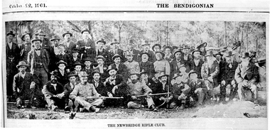
... The Newbridge Rifle Club Butts were behind a big hill north... were behind a big hill north of road to Llanelly. Formed ...The Newbridge Rifle Club Butts were behind a big hill north of road to Llanelly. Formed in 1900 for rifle practice during the Boer War. Range of 500 yards. Brigade Captain Bob Douglas. Murray Comrie Collection. Two copies of a monochrome photograph, image depicting a large group of men assembled in an outdoor setting, some holding firearms. Printed caption reads: 'The Newbridge Rifle Club' Title printed on top of page reads 'The Bendigonian' and 'October (?) 22 1901'. This is a poor quality copy of an older original, possibly a news clipping. Copy probably made by Murray Comrie in the 1960s.Accompanying note identifies some subjects: Standing: 1. Will Hart (?) 2. _________ 3. John Brown 4. Donald Joyner 5. Geo. Daws 6. _______ 7. Nat Ramsay 8._______ 9.__________ 10. Alf Michael 11. Bod Hamilton 12. Jack Bruce 13. Vince Pola 14. Frank Bruce 15. Eli Summers 16. ____ 17. ____ 18. ______ 19. Bob Chamberlain 20. P. Rayner 21. Ted Skinner 22. Geo. Martin 23. Bill Michael. Sitting: 1. ______ 2.______ 3. ______ 4. Will Ramsay 5. Nat Hart 6. Bob Douglas (in uniform) 7. Jim Joyner 8. Steve Hatt 9. Bob McKenzie 10. Charlie Summers (in uniform) 11. William Bridge (in uniform) 12. Tom Michael (in uniform). (Not sure if this matches the photo very well. Note filed in M. Comrie research notes (general).)newbridge, sports, recreation, shooting, clubs, rifle club, military, boer war -
 Bendigo Historical Society Inc.
Map - BIG 180 SHAFT POSITION, No date visible
... Bendigo mining plan Mining Gold Mines. Victoria Hill Big 180 Map ...Map: Plan showing the location of various shafts in the Victoria Hill area, hand draughted in pencil. Scale 2 Chains to 1 inchmap, bendigo, mining plan, mining , gold mines. victoria hill, big 180 -
 Stawell Historical Society Inc
Drawing, Grampians Scenes -- Sketches
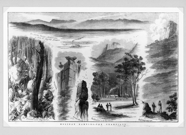
... - Grampians from the Big Hill Stawell. The Descent to the Gap Valley... - Grampians from the Big Hill Stawell. The Descent to the Gap Valley ...Very detailed drawings of scenes of the Grampians. Artist S. Calvert.Black and white detail drawings of series of mountain scenes. Holiday Rambles - The Grampians The Sierra Range - Grampians from the Big Hill Stawell. The Descent to the Gap Valley. The Anvil Rock. Barneys Chimney. The "Selection" in the Gap Valley. Only half way up. Reproduction Rights Reserved Copied by State Library of Victoria on the back stawell -
 Stawell Historical Society Inc
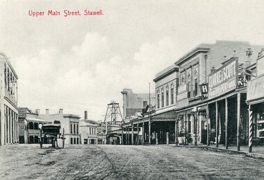
Postcard, Upper Main Street Stawell looking East with on left the 2 story Allingham building & behind the cart is the Commercial Hotel c1910
... Upper Main Street Stawell looking towards Big Hill... grampians Upper Main Street Stawell looking towards Big Hill ...Upper Main Street Stawell looking towards Big Hill. Sloane's Scotchman's Poppet Head in background. 1906. Victoria House, Commercial Hotel, Oriental Bank, Weekly Times Office, Clarke & Sons Drapery. Same as 1423 & 2785Steet scene looking East down Upper Main Street from Victoria Street. Crown Cross Poppet Head at end of main street and side of Mechanics Institute at centre of image.Post Cardstreetscape, mining -
 Kiewa Valley Historical Society
Photograph - Folder of Photographs – Photocopied set of black and white photographs (pages 39 - 48) from the display folder put together by KVHS to document life on the Kiewa Valley Hydro-electric Scheme
... and their families. 1-Breakdown in Circuit Breaker (Isolating Contacts) 2-Big... 39 2-Big Hill Bench – Site of No. 5 Development (abandoned... Kiewa Scheme Page number 39 2-Big Hill Bench – Site of No. 5 ...Although the Kiewa Hydro-Electric Scheme was first proposed in 1911, construction did not commence until 1938. As part of the push to cut electricity costs and diversify supply, the Victorian Government (circa 1930) initiated the conversion from primarily brown coal supply to hydro – electricity. Field investigations during the 1940’s resulted in a new proposal for a scheme that had more than double the capacity of the 1938 scheme. The Kiewa Hydroelectric Scheme became the largest scheme of its kind in the State Of Victoria and the second largest scheme in Australia. The number of personnel involved in the planning and construction of the scheme increased dramatically. During the late 1940’s, most activity centered around the construction of the West Kiewa Power Station, Rocky Valley Reservoir, McKay Creek Power Station and the Bogong Creek Aqueduct.A common thread across all the larger hydro scheme constructions was the need for workers, both qualified and unqualified who came from around the world seeking a new life for themselves and their families. New accommodation and facilities were required for the army of workers engaged in construction in often remote and wild areas. The SEC had a high demand for timber, and set up the first of a number of sawmills at Bogong Creek in 1939 and set up the first hardwood logging in the headwaters of the Kiewa River. These new ‘towns’ such as Mt Beauty and Bogong, survived, serving the needs of operational personnel and their families, and expanding with growth of new industries. Mount Beauty, and to a lesser extent Bogong, are among these places. Large A3 size spiral bound display folder containing photocopied black and white photographs of various aspects of the early days of the Kiewa Valley Hydro-electric scheme including equipment, various work sites and photographs of workers and their families. 1-Breakdown in Circuit Breaker (Isolating Contacts) 2-Big Hill Bench- Site of No 5 Devlopment 3-No 1 Power Station 4-No 1 Pipeline, Anchor No 8 5-Push Dozing-RD8 Tractor 6- Tractor and driver at work 7- Workmen in unnamed tunnel 8- Front page of Journal of SECV Vol 15. Photograph of No 1 pipeline viewed from McKay Portal 9-Rocky Valley Dam Core Wall 10-Workmen working inside tunnel loading rocks into a rail truck. 1-Breakdown in (generator) Circuit Breaker (Isolating Contacts) Handwritten underneath (This is not a picture of any part of a generator. It is a circuit breaker Signed Ron White Ron was the Principal Hydro Engineer of the SEC Kiewa Scheme Page number 39 2-Big Hill Bench – Site of No. 5 Development (abandoned) Page number 40 3-No 1 Power Station Page number 41 4-No. 1 Pipeline, Anchor No. 8 Page number 42 5-Push Dozing – RD8 Tractor, 12 cubic yard Carryall and FD Cletrac Tractor Page number 43 6-No marking Page number 44 7-No marking Page number 45 8-Journal of State Electricity Commission of Victoria SEC Vol 15 No… April-May, 19… No 1 Pipeline-A view from McKay Portal G Hempenstall and D Sutton stiffening pipe section for transport during construction (….indicates missing text) Page Number 46 9-Rocky Valley Dam Core Wall Page number 47 10-No markings Page number 48 secv; kiewa hydro electric scheme; construction area; power stations; reservoirs; aqueduct; mt beauty; bogong -
 Stawell Historical Society Inc
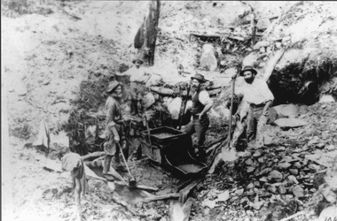
Photograph, Mining Scene at Quartz Reefs, St Georges Lead. Three miners with a gold rocking cradle
... Miners around Big Hill area at work St Georges Lead c 1860... grampians Miners around Big Hill area at work St Georges Lead c 1860 ...Miners around Big Hill area at work St Georges Lead c 1860's. Note gold rocking cradle. This photo was amongst several mining photos, all of which were identified and catalogued under their correct mine name in 2010-2011.Three men with shovels around a gold mine cradle on a rocky hill side.stawell -
Bendigo Historical Society Inc.
Map - CAMPBELL COLLECTION: BENDIGO AND DISTRICT MAPS, 21-8-1972
... , Melbourne to Bendigo Railway Line, Big Hill Tunnel, Mt.Herbert 1596... Railway Line, Big Hill Tunnel, Mt.Herbert 1596. (number 398 in map ...Map. Shire of Strathfieldsaye Locality Plan. Scale 1 inch=1 mile. Drawn by M.Higgs 21-8-1972, Shire of Huntly, Shire of McIvor, City of Bendigo, Shire of Marong, Shire of Maldon, Shire of Metcalfe, Lake Eppalock, Axedale Township, Strathfieldsaye Township, Melbourne to Bendigo Railway Line, Big Hill Tunnel, Mt.Herbert 1596. (number 398 in map cupboard 1)M.Higgs 21-8-1972map, bendigo, locality plan -
 Stawell Historical Society Inc
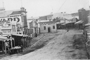
Photograph, Enlargement of Catalogue number 0541 of Main Street looking East featuring the Star Hotel, 1890's
... of Main St. looking East towards Big Hill. From left Herbert... of Main St. looking East towards Big Hill. From left Herbert ...Enlargement of right hand side of photo 0541. Top end of Main St. looking East towards Big Hill. From left Herbert Photographic, T Brown, Star Hotel on bend jutting out into middle of road. Mechanics Institute in background. Two Horse wagon in street on left.stawell businesses streetscape -
 Stawell Historical Society Inc
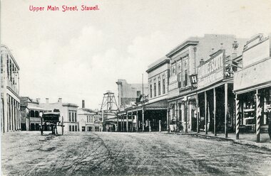
Photograph, Upper Main Street Stawell looking East with on left the 2 story Allingham building & behind the cart is the Commercial Hotel c1910
... visible on Big Hill. The side of the Mechanics Institute visible... on Big Hill. The side of the Mechanics Institute visible near ...Upper Main Street Stawell. Looking East c1910. On left two story Allingham building behind cart is Commercial Hotel. Oriental Bank. Punchard Furniture. Crown Cross Poppet head visible on Big Hill. The side of the Mechanics Institute visible near centre. H S Dawson Chemist. Clarke & Scott Drapery on right. Same as 6730-1 & 1423Streetscape of upper main street looking east, Crown Cross poppet head at end of street in middle of streetUpper Main Street Stawell.mining, streetscape, businesses -
 Stawell Historical Society Inc
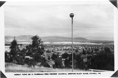
Photograph, Panorama of Stawell from Pioneer's Memorial, towards the Black Range. Murray Views No.13
... in background, grassland on Big Hill at front of Photo. St Patrick's... in background, grassland on Big Hill at front of Photo. St Patrick's ...Murray Views No. 13. Panorama over Stawell, looking South West. Spotlight on Pioneer's Memorial (29,5). Black Range in background, grassland on Big Hill at front of Photo. St Patrick's Church visible, Kinsella House. The larger photo 29.5a is a slightly closer view of same scene and shows the "new" school (corner Patrick & Holt Street) opened in 1934.Two similar views of Stawell. One Murray views looing south west (29.5) and the other a larger photo showing school building beside church (29.5a).Murray Views No.13. Panorama from Pioneer's Memorial, showing Black Range, Stawell, Vic. (on 29.5)stawell, panorama -
 Kiewa Valley Historical Society
Photograph - Folder of Photographs – Photocopied set of black and white photographs (pages 9 - 18) from the display folder put together by KVHS to document life on the Kiewa Valley Hydro-electric Scheme
... 4- Diamond Drilling Plant – Big Hill 5-Rocky Valley Camp... Drilling Plant – Big Hill Page number 12 5- STATE ELECTRICITY... Plant – Big Hill Page number 12 5- STATE ELECTRICITY COMMISSION ...Although the Kiewa Hydro-Electric Scheme was first proposed in 1911, construction did not commence until 1938. As part of the push to cut electricity costs and diversify supply, the Victorian Government (circa 1930) initiated the conversion from primarily brown coal supply to hydro – electricity. Field investigations during the 1940’s resulted in a new proposal for a scheme that had more than double the capacity of the 1938 scheme. The Kiewa Hydroelectric Scheme became the largest scheme of its kind in the State Of Victoria and the second largest scheme in Australia. The number of personnel involved in the planning and construction of the scheme increased dramatically. During the late 1940’s, most activity centred around the construction of the West Kiewa Power Station, Rocky Valley Reservoir, McKay Creek Power Station and the Bogong Creek Aqueduct.A common thread across all the larger hydro scheme constructions was the need for workers, both qualified and unqualified who came from around the world seeking a new life for themselves and their families. New accommodation and facilities were required for the army of workers engaged in construction in often remote and wild areas. The SEC had a high demand for timber, and set up the first of a number of sawmills at Bogong Creek in 1939 and set up the first hardwood logging in the headwaters of the Kiewa River. These new ‘towns’ such as Mt Beauty and Bogong, survived, serving the needs of operational personnel and their families, and expanding with growth of new industries. Mount Beauty, and to a lesser extent Bogong, are among these places. PHYSICAL: Large A3 size spiral bound display folder containing 21 pages of photocopied black and white photographs of various aspects of the early days of the Kiewa Valley Hydro-electric scheme including equipment, various work sites and photographs of workers and their families. 1-Bridge across Tailrace Channel 1946 2-New Mess building, Mt Beauty 3-Homan’s Gap Saw Mill 4- Diamond Drilling Plant – Big Hill 5-Rocky Valley Camp-Mess Building 6-Parlimentary Party at Rocky Valley 7-No.4 Headrace Tunnel 8- Allis-Chalmers Tractor School 9- SECV Heavy Machinery lined up by road 10- No. 5 Raceline – Balasting Track with improvised truck 1-1946 – Bridge across tailrace channel Page number 9 2-New mess building, Mt Beauty 6.4.46 Page number 10 3- STATE ELECTRICITY COMMISSION OF VICTORIA Date: 10.1.47 Time: 11.40am No K2271 Kiewa Hydro Electric Works Homan’s Gap Saw Mill – Rip Saw Page number 11 4- STATE ELECTRICITY COMMISSION OF VICTORIA Date: 5.10.47 Time: 11am No K4111 Kiewa Hydro Electric Works Diamond Drilling Plant – Big Hill Page number 12 5- STATE ELECTRICITY COMMISSION OF VICTORIA Date: 11.2.48 Time: 3pm No K4277 Kiewa Hydro Electric Works Rocky Valley Camp-Mess Building Page number 13 6- STATE ELECTRICITY COMMISSION OF VICTORIA Date: 15.4.48 Time: 4.30pm No K4397 Kiewa Hydro Electric Works Parlimentary Party at Rocky Valley Page number 14 7- STATE ELECTRICITY COMMISSION OF VICTORIA Date: 22.8.48 Time: 9am No K4668 Kiewa Hydro Electric Works General view of No.4 Headrace Tunnel Page number 15 8-STATE ELECTRICITY COMMISSION OF VICTORIA Date: 5.9.49 Time: 10am No K5180 Kiewa Hydro Electric Works Allis-Chalmers Tractor School – HD 19, Mr I Crossthwaite at Controls Page number 16 9- No markings Page number 17 10- STATE ELECTRICITY COMMISSION OF VICTORIA Date: 7,12.49 Time: 4pm No K5423 Kiewa Hydro Electric Works No. 5 Raceline – Balasting Track with improvised truck. Page number 18 secv; kiewa hydro electric scheme; mt beauty; bogong; construction area -
 Bendigo Historical Society Inc.
Slide - Peter Ellis Collection, Kaweka Wildflower Reserve, Castlemaine, Lightning Hill Lookout Bendigo, One Tree Hill Lookout Tower Bendigo, Kamarooka Forest Area, c1970-1972
... bee clearing along a pipeline at Big Hill. Peter...; and a working bee clearing along a pipeline at Big Hill. Peter ...Kaweka Reserve is a a small reserve of approximately 8ha. The land was donated to the Castlemaine City to be a wildflower Reserve. A management committee was formed in 1966. The committee is still managing the park. Vicroads Edition 6: Map 59E2, 628 H4 Location. Turner St, Castlemaine. From the Castlemaine Post Office, drive north (towards Bendigo) and turn right along Turner Street to the park entrance. What to do: walk along some of the tracks through the park follow the nature trail bird watch have a picnic at the picnic tables. RUSH Dam is a basic free camping area sits alongside Rush Dam in the Greater Bendigo National Park, featuring a single picnic table and wood fire barbecue.Peter Ellis Collection: Seventeen slides of Kaweka Wildflower Reserve, Castlemaine, Lightning Hill Lookout Bendigo, One Tree Hill Lookout Tower Bendigo. Also the Rush Dam free camping area at Kamarooka. Also a slide of an unknown group having a meal or day out; perhaps also a working bee. In addition there are two slides of a house - location not specified; and a working bee clearing along a pipeline at Big Hill. Peter was a chemistry lecturer at the Bendigo Institute of technology.history, bendigo, peter ellis collection, whipstick bendigo, bendigo state forests, kaweka wildflower reserve castlemaine, one tree hill lookout bendigo, lightning hill lookout bendigo, kamarooka, rush dam kamarooka, greater bendigo national park -
 Stawell Historical Society Inc
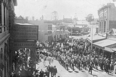
Photograph, Upper Main Street Stawell procession with the band & a police constable on Horseback visible c1901
... . Poppet Head in background on Big Hill on left is Crown Cross.... Poppet Head in background on Big Hill on left is Crown Cross ...Main Street Procession East End Circa 1901. Stawell Brass Band plus Constable on Horseback visible. J Chadwick Importer of General Drapery with Boys Clothing on sign on left. Millinery on side of verandah. Commercial Hotel just visible on left. Sloane's & Scotchmans Poppet head Visible in background on right. Poppet Head in background on Big Hill on left is Crown Cross shaft.Croud of people lead by band in upper main street. Chadwick drapers on left. Mounted policeman on horseback in front of Commercial Hotel.stawell businesses streetscape -
 Bendigo Historical Society Inc.
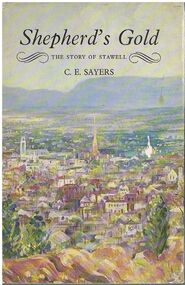
Book - ALEC H CHISHOLM COLLECTION: BOOK ''SHEPHERD'S GOLD'' BY C.E.SAYERS
... a picture of Stawell from Big Hill from the painting by John Glover... jacket has a picture of Stawell from Big Hill from the painting ...Book. ALEC H CHISHOLM COLLECTION. 194 page hardcover book by C. E. Sayers, Shepherd's Gold, the story of Stawell, Victoria. Includes 36 B & W photographs and the dust jacket has a picture of Stawell from Big Hill from the painting by John Glover. Published in 1966 by F. W. Cheshire Pty Ltd. And printed by Griffen Press. Catalogue sticker ''2190 SAY'' on spine. Handwritten in ink on flyleaf ''For Alec Chisholm Sincerely C. E. Sayers 10, October 1966.''C. E. Sayersbooks, collections, history, alec h chisholm collection, c.e.sayers, stawell, history -
 Bendigo Historical Society Inc.
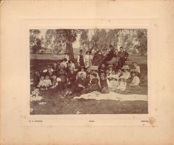
Photograph - GROUP PORTRAIT - PICNICKING IN BUSH
... ? Potentially picnic is at Ravenswood. Appears to have Big Hill range.... Appears to have Big Hill range in background, road with white ...Black and white image mounted on cream board : image shows large group of men, women and children, sitting, standing and reclining on grass. Eucalyptus trees in background, horse grazing. Man at rear of group is seated on a horse. Man behind horse's head is pouring a bottle into a glass. Circa late 1800's ? Potentially picnic is at Ravenswood. Appears to have Big Hill range in background, road with white posts running across background. On bottom of image on board ' W.H. Robinson, photo, Bendigo'W.H. Robinson, Bendigocottage, miners, bendigo, picnic, family, ravenswood. photographer w. h. robinson, bendigo. -
 Kiewa Valley Historical Society
Photograph of Kiewa Valley Panorama, Kiewa Valley from No. 5 Road, Before 1945
... to West Kiewa Power Station and Big Hill Scenic Lookout.... Power Station and Big Hill Scenic Lookout. Is an excellent view ...In 1943 a camp for workmen was erected and a commencement made with the erection of plant storage and workshop buildings in the new township of Mt. Beauty. The photograph was probably taken after the completion of these buildings. There is no sign of construction of the town itself. In the latter part of 1945 work was commenced on the Mt. Beauty township area with a medical centre, general trading store and some houses under construction. The No. 5 Road, from where the photograph was taken, is the road to West Kiewa Power Station and Big Hill Scenic Lookout.Is an excellent view of the Kiewa Valley before there was little work undertaken to establish the town of Mt. Beauty. Farming was well established with the evidence of huge areas of cleared land. The junction of the East and West Kiewa Rivers can be clearly seen. The first Workmen's camp is near the river and some workshop buildings can also be seen. Black and white photograph of the Kiewa Valley, looking North.Handwritten on the back of photograph "Kiewa Valley from No. 5 Road".kiewa valley, camp, buildings, mt. beauty -
 Bendigo Historical Society Inc.
Document - EXTRACT FROM THE BENDIGO INDEPENDENT APRIL 16 1887: MYERS FAMILY/MYERS CREEK, 16th April, 1887
... ) M'Intyre (squatter of Kangaroo Flat and Big Hill) ; Buzza's Paddock... Flat and Big Hill) ; Buzza's Paddock (Myers' Flat). Mention ...Extract from the Bendigo Independent April 16 1887 re Myers Family/Myers Creek. Titled The local dawn of civilization - A Pre-auriferous pioneer. Settlement by William and Thomas Myers. Story of settlement of area told by first wife of William Myers (Mrs Hayward). Recollection of Mrs Hayward's re the naming of Bendigo ( ('bendy-go'). Reference to Mr Campbell, Bullock Creek Hotel and Station; Mr John Catto (Loddon homestead); Mouat Bros (Yarraberb Station) M'Intyre (squatter of Kangaroo Flat and Big Hill) ; Buzza's Paddock (Myers' Flat). Mention of Superintendent Gilbert and Dr Backhaus.Bendigo Independentperson, individual, myers family, myers flat police station, buzz's paddock, bullock creek hotel and station, port phillip, myers creek. -
 Stawell Historical Society Inc
Photograph, Patrick Street and the Corner of Sloane Street with Stawell Court House in the background & St Patricks Church on the Horizon 1878
... (Herbert Photo) On Big Hill side of Patrick Street is Matthew... (Herbert Photo) On Big Hill side of Patrick Street is Matthew ...Patrick Street Sloane Street intersection in the 1880’s (Herbert Photo) On Big Hill side of Patrick Street is Matthew Cairns Plumber & Gasfitter, R. Greenwood Tailor, Mrs. Goodwin Cafe & Restaurant, Mack's Hotel, Grocer, Boot and Shoemaker, J. Farleys Auction Room, J.B. Wallis Royal Exchange Hotel, Stawell Court House and St Patricks Church in Distance On corner of Patrick and Sloane Streets, Melbourne Cash Store Wine Spirits & Provisions. In background mining poppet head behind livery stable. St Patrick Church in distance on right. 1878Patrick St, Sloane St intersection looking south . The Stawell Library now occupies this corner.Victorian Views. C. Herbert, Photo. Stawell 1878stawell business streetscape -
Bendigo Historical Society Inc.
Document - MINING WARDEN COLLECTION: BENDIGO HISTORICAL MINING RECORDS
... Myers Flat Birds Hit or Miss Break of Day Crusoe Big Hill line... Crusoe Big Hill line Sample entry: Brilliant Co., BEN# 3757 ...Historical records originally from the Mining Warden's Office, Mines Department, Bendigo. Information collated from 1870's to 1980's. A summary document lists the BEN# from 3754 to 4080 and describes the mine name; the BEN#, the line of reef located on, the start and end year. Individual mine data is enclosed in a manilla folder within the box. Reef lines listed are: Derby Christmas Garden Gully Gravel Hill Thistle Carshalton Myers Flat Birds Hit or Miss Break of Day Crusoe Big Hill line Sample entry: Brilliant Co., BEN# 3757, Garden Gully line of reef, 1870 - 1880.bendigo, mining, mining warden records -
 Kiewa Valley Historical Society
Photograph - Mt Beauty Camp, Estimated 1950-1951
... to Big Hill beyond that.... with Mt. Beauty behind the township rising to Big Hill beyond ...This photo is of the very newly constructed State Electricity Commission town of Mt. Beauty. The houses up to Nelse street were erected from 1946 onward and then the township was extended beyond Nelse Street in 1950 which places this photograph about 1950/51. There is no evidence of work being commenced on the regulating pondage but the tail race canal can be seen on the centre right of photo. The workmen's camp was enlarged in 1950 to the extent of providing accommodation for a total of 1,200. There are a number of dwellings on Simmonds Creek and the road to Falls Creek can clearly be seen. Snow capped Mt. Bogong is in the upper left of the photo with Mt. Beauty behind the township rising to Big Hill beyond that.Shows the newly constructed town of Mt. Beauty surrounded by farmland and before the regulating pondage was built to discharge water from the power stations via the West Kiewa tail race tunnel into the Kiewa River. Copy of black and white photograph of Mt Beauty CampWritten on the back in black ink - A Campenmt beauty camp, secv, construction town -
 Kiewa Valley Historical Society
Photograph of Mt. Beauty, Mt. Beauty from transmission line, Approx 1950/51
... to Big Hill beyond that.... with Mt. Beauty behind the township rising to Big Hill beyond ...This photo is of the very newly constructed State Electricity Commission town of Mt. Beauty. The houses up to Nelse street were erected from 1946 onward and then the township was extended beyond Nelse Street in 1950 which places this photograph about 1950/51. There is no evidence of work being commenced on the regulating pondage but the tail race canal can be seen on the centre right of photo. The workmen's camp was enlarged in 1950 to the extent of providing accommodation for a total of 1,200. There are a number of dwellings on Simmonds Creek and the road to Falls Creek can clearly be seen. Snow capped Mt. Bogong is in the upper left of the photo with Mt. Beauty behind the township rising to Big Hill beyond that.Shows the newly constructed town of Mt. Beauty surrounded by farmland and before the regulating pondage was built to discharge water from the power stations via the West Kiewa tail race tunnel into the Kiewa River. Black and white photographHand written on back of photograph "Mt. Beauty from Transmission Line"mt. beauty, construction, pondage, state electricity commission -
 Stawell Historical Society Inc
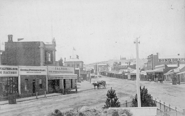
Photograph, Main Street Stawell looking East from the Present War Memorial site 1878
... Main St. looking East towards Big Hill from Coffee Palace... grampians Main St. looking East towards Big Hill from Coffee Palace ...Main St. looking East towards Big Hill from Coffee Palace Verandah over Present War Memorial area. 1878 Businesses from left Walters and Son Factory, General Furnishing Mart, Stawell Town Hall, J. & A. Price Wine Spirits & Provision Merchants, Stawell Post Office. On right south side of Main Street, two-storey wooden Bull & Mouth Hotel, Whiteside Taylors, Carters Boot shop, Lecky Draper, C. Mulcahy Post Office Hotel, G.J. Hewlett Baker & Confectionery, Iron Monger, Victoria House Bond Draper, Town Hall Hotel, J. Richards Fancy Repository. Victorian Views. C. Herbert, Photo. Stawell 1878stawell business streetscape -
 Stawell Historical Society Inc
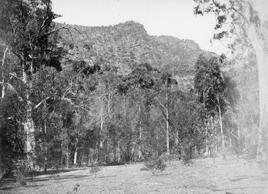
Photograph, Grampians at Halls Gap 1866
... the mountain in a tunnel, before being piped to a reservoir on Big Hill... the mountain in a tunnel, before being piped to a reservoir on Big Hill ...Grampians Halls Gap. Part of a collection of Photographs by Mr. O.G. Armstrong as commissioned by the Shire of Stawell for the Inter-colonial and Paris Exhibition in Melbourne in 1866. From about 1860 there was agitation for a water supply, not only for Stawell but for the Wimmer Mallee as well. In 1887 Wartook was adopted as the first reservoir for the Wimmer. Stawells water supply was designed by Mr. John D’Alton. The scheme came from Fyan’s Creek via Wooden Fluming and a Syphon and finally through the mountain in a tunnel, before being piped to a reservoir on Big Hill. The system was completed in December 1881 and although there have been modifications, basically it has not been changed to this day. The Wimmera Mallee stock and domestic system from the Grampians is the largest system of its kind in the world, the latest edition being like Belfield and piping of Wimmera channels. stawell -
 Bendigo Historical Society Inc.
Photograph - VIEWS OF BENDIGO: COPIES OF 52 PHOTOS, 1850 - 1900
... looking west No 39 Tunnel Big Hill. No 40 From St Paul's tower... No 38 From St Paul's tower looking west No 39 Tunnel Big Hill ...Copies of Photographs from - Views of Bendigo by Nicholas Caire Originals in Box 13 No.1 Sandhurst east/ City Reserve x 2 No 2 New Chum Line of Reef No 3 Sandhurst to North from top of Masonic Hall No.4 Hustler's Line of Reef No.5 Battery of stampers for crushing quartz x 2 No.6 View Sandhurst from top of Masonic Hall x 2 No.7 Excavation Quartz Reef, Ironbark Hill. No 8 St. Paul's Church. No.9 View Camp Reserve from Court House. No.10 View of Nth. Old Chum. No.11 View Camp Hill near the Lodge x 2 No.12 Garden Gully. No.13 Shamrock Hotel, Sandhurst. No.14 View from Court House, east end Pall Mall. No.15 Wesleyan Church, Golden Square x 2 No.16 Savings Bank, Sandhurst No.17 Bendigo District Hospital. No.18 Interior Wesleyan Church x 2 No.19 View Golden Square township. No.20 The Town Hall, Sandhurst. No 21 The City Hotel,Sandhurst. No 22 Pall Mall Sandhurst, No 23 Sandhurst City Market No 24 Pall Mall looking west x 2 No 25 Camp Hill x 2 No 26 Charing Cross No 27 View Sandhurst. x 2 No 28 Long Gully. No 29 Railway station and sheds No 30 Cemetery Back Ck. No 31 Kock's Pioneer Quartz Crushing Plant Long Gully. No 32 Masonic Hall. No 33 Bendigo Benevolent Asylum. No 34 Bendigo Flat. No 35 Old Chum Hill x 2 No 36 New Chum Gully No 37 Township of Eaglehawk No 38 From St Paul's tower looking west No 39 Tunnel Big Hill. No 40 From St Paul's tower looking south x 2 No 41 From St Paul's tower looking eastward x 2 No 42 From St Paul's tower looking north west x 2 No 43 Great Extended Hustlers Quartz Mining Claim No 44 Big Hill Rail line x 2 No 45 From St Paul's tower looking westward x 2 No 46 From St Paul's tower looking north west No 47 Big Hill Ranges Buick. x 2 No 48 St.Paul's Tower x 2 No 49 Eaglehawk township. No 50 Mitchell Street No 51 Botanical gardens, White Hills x 2 No 52 View Point, Sandhurst. .N.J. Caire.place, bendigo, bendigo area., views of bendigo. -
 Bendigo Historical Society Inc.
Document - VARIOUS DRAFT ARTICLES FOR RHSV (BENDIGO) NEWSLETTER FEB 1972
... 1972. 1 Big Hill Tunnel: description of memories by Lydia... for RHSV (Bendigo) Newsletter Feb 1972. 1 Big Hill Tunnel ...Various draft articles for RHSV (Bendigo) Newsletter Feb 1972. 1 Big Hill Tunnel: description of memories by Lydia Chancellor of outings to area (Picnic Day); 2. Article by A W (Lew) Llewellyn re (fist fighting) Champions of England in 1700s and 1800s (incl details of ‘‘Thompson (w.) Bendigo'' - source ''Fistiana, pub. 1857); 3. ''Phenomenal Hail Storm'' by Edith Checcucci(?) description of hail-storm of March 27th, 1914 - hail 18'' thick in Hargreaves Street - describes damage from personal recollection as a child and Annals of Bendigo from March 1914; 4. Note from Neil Murray, President entitled ''Vale - Albert Richardson; obituary and condolences to family; 5. article by ''Jock'' re Chinese Masonic Hall, Bridge Street, and the future of this building describing the nature of the building, uses, owners/occupiers; 6. Handwritten original of #5 - named author; J O'C Hattam (''Jock'')document, newspaper, bendigo advertiser