Showing 14801 items
matching corner
-
 Ringwood and District Historical Society
Photograph, Corner Adelaide St. and Civic Place, Ringwood 1966. Later parking area for Eastland
Typed below photograph, "Corner Adelaide St. and Civic Place. Now parking area for Eastland - 1966". -
 Ringwood and District Historical Society
Photograph, South east corner of Mines Road and Maroondah Highway, Ringwood. 1981
Written on back of photograph, "24/7/81. South east corner of Mines Road and Maroondah Highway." -
 Ringwood and District Historical Society
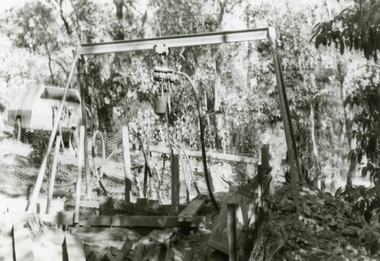
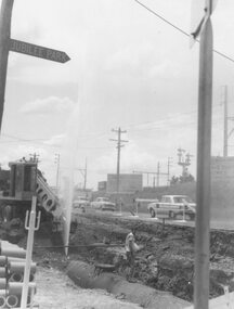
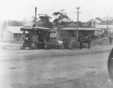
Photographs, 1979-80 MMBW pipe line project at Hubbard Reserve, North Ringwood � Air winch over the hole in the corner of Chalkley's
Part of a 43-photo record of the MMBW�s engineering feat in drilling a 12 inch pipe line up to 40 feet deep through rock hardened by volcanic action associated with geological fault that occurs along the line. The work took place from October 1979 to May 1980 on the southern boundary of Hubbard Reserve, North Ringwood. The collection was presented to the Ringwood Historical Research Group by J Clarke on 9th June 1980.E561 N1 Feb 1980 A43 Air winch over the hole in the corner of Chalkley's (lot 8) -
 Ringwood and District Historical Society
Photograph, Maroondah Highway East, Ringwood- 1964. Water main repair work on the north-east corner of Maroondah Hwy and Warrandyte Road
Black and white photographWritten on back of photograph: "Corner Maroondah Highway and Warrandyte Rd. Water main repair work,1964". -
 Ringwood and District Historical Society
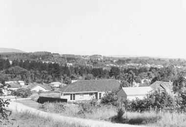
Photograph, Ringwood East looking from corner Warrandyte Road and Wonga Road, 1960
Written on back of photograph, "Ringwood East looking from corner Warrandyte Road and Wonga Road, 1960". -
 Ringwood and District Historical Society
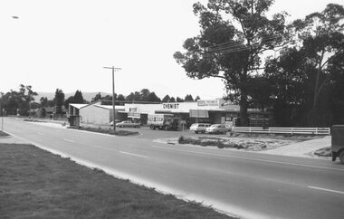
Photograph, Canterbury Road shops, corner Armstrong Road, Heathmont, looking east - 1973
Catalogue card reads, "Canterbury Road shops, corner Armstrong Road, Heathmont, looking east - 1973". -
 Whitehorse Historical Society Inc.
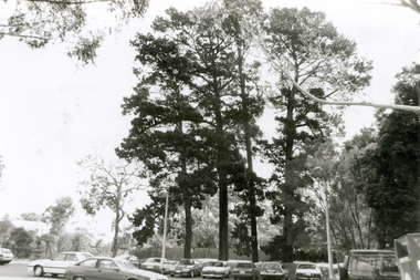
Photograph, Corner Doncaster East & Mitcham Roads, 2000
Produced as one of a series of 24 prints commissioned by Nunawading & District Historical Society -|Theme: Intersections of Mitcham and Nunawading 2000/2001.|See also Series by P. Simmenauer on the same theme.Black and white photograph - print and negative of Corner of Doncaster East Road and Mitcham Road, looking North. Four tall pine trees and parked sedan cars backing on to Mitcham Private Hospital.doncaster east road, mitcham, mitcham road, mitcham & district private hospital -
 Surrey Hills Historical Society Collection
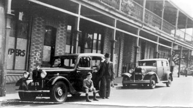
Photograph, Sunbury Crescent, Surrey Hills looking towards the corner of Union Road, 1930s, 1930
Date is approximate. This is one of a series of photos donated by Arthur Lyons. Lyons family history: Arthur's father, Fred Lyons initially worked for George Rea's cab service until he set up his own business. He started with a horse and hansom cab but in time he changed over to a motor vehicle and continued his service until 1960. Frederick Adolphus Lyons (1891-1980) was born in Surrey Hills, son of Thomas and Catherine Lyons. He married Elizabeth Ruby Hall in 1918. They lived at 55 Sunbury Crescent. The Lyons’ home in Sunbury Crescent was called ‘Knopshambury’ - this was probably a misspelling of Knockshanbally in Co Kilkenny, the birth place of Fred’s father, Thomas Edmund Josias Lyons (1846-1915). Arthur Lyons was born in Surrey Hills on 12 Jun 1920. He became a motor mechanic / welder and lived his whole life at 55 Sunbury Crescent. The donation was made while he was in hospital. He died shortly afterwards (23 Sep 1990). Donation was finalised by a neighbour, Mrs Florence Ann Armitstead, wife of Glen Victor Armitstead. Glen was a local hairdresser. They moved to 11 Sunbury Crescent after their marriage in 1939. Arthur had no relatives to distribute the material to. The buildings date from circa 1887 and extended some way down Sunbury Crescent. The address was 63 Sunbury Crescent on the corner of Union Road. Built by Albert Mills for the Premier Land Agency; taken over by Timothy Leigh in 1893. The building housed a variety of shops – initially the land agency, but later shops included at various times a fruiterer, florist, carpenter, fishmonger, upholsterer, plumber. However, by the time this photo was taken in the 1930s it was occupied by Triumph Press. The printing industry continued to have a lasting presence. Triumph Press was followed by Surrey Press and in 1970 New Life Publications moved to the site from Abbotsford. It was about this time that this original building was demolished to make way for a modern print works. Gradually the needs of the printing business absorbed other properties along the Union Road frontage. The boy in the photo is Arthur (Tiger) Lyons and beside him is Alf Johnson, the local printer. The Lyons family lived adjacent to these buildings at 55 Sunbury Crescent.Black and white photo of a section of double-storey terrace buildings in Sunbury Crescent Surrey Hills, taken looking towards the corner of Union Road. The bricks are two-toned and laid in herringbone pattern. The verandah on the 2nd story is filled in with cast-iron lacework panels. There are 2 vintage cars in front of the terrace. A young boy sits on the running board beside a man dressed in suit and hat. printers, vintage cars, sunbury crescent, victorian style, union road shops, arthur lyons, arthur frederick lyons, alf johnson, triumph press, surrey press, new life publications, timothy leigh,, albert mills -
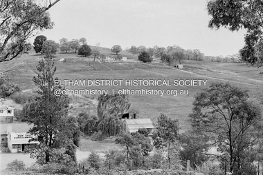 Eltham District Historical Society Inc
Photograph, Barry Philp, Second Hand store at the southeast corner of Reynolds Road and Main Road, Eltham, c.1969
Corner of Reynolds Road. The store is on the left, the house on the right was the home of the Dodkins family (Phographer Barry Philp's uncle and aunty). The house on the hill was Philbrick's home which burnt out in the bush fires.bushfires, dodkins family home, fire damage - buildings, main road, philbrick family home, research (vic.), reynolds road, second hand dealer, victorian bushfires - 1969, eltham, eltham-yarra glen road -
 Stawell Historical Society Inc
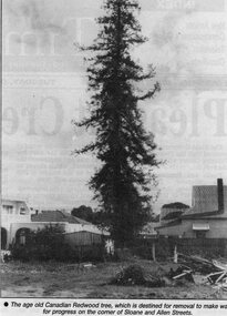
Newspaper, Canadian Redwood tree at 17 Sloan Street and corner of Allen Street 1996
Tree. Canadian Redwood. 17 Sloan Street and corner of Allen Street. 1996. House called "Bedale" demolished in 1996 was built in 1903 probably the home of George Kay of Wayman and Kay Foundry. stawell entertainment -
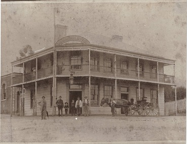
 Stawell Historical Society Inc
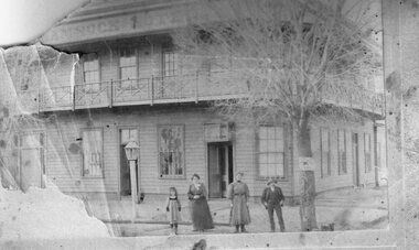
Photograph, Shamrock Hotel on the corner of Seaby & Longfield Streets Stawell West with Mary Jenkins and Agnes Jenkins nee Keegan 1905. Plus a series of related people
Two story weatherboard Shamrock Hotel in 1905 corner of Seaby Street and Longfield Streets Stawell West. Standing in Front from left are Mary Jenkins and Agnes Jenkins. Note street light.Large two Story Hotel with verandah and railings. Two women man and young girl standing at front. Light pole prominent centre left of photo.Shamrock Hotelstawell business -
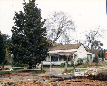
 Ringwood and District Historical Society
Photograph, Ringwood Reserve. Looking to SE Corner and Dickins Store, mid 1960's
3 copies of same photo. Written on backing sheet of one, "Ringwood Reserve. SE corner, 1962". On another "Ringwood Reserve Looking South 1966". On Another: "NBE Corner Rwd Reserve. Building on Right is "Dickins" Facing Melb St. " 1962 -
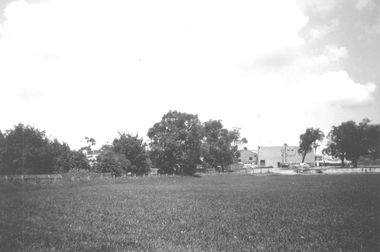
 Eltham District Historical Society Inc
Photograph, Cottage, corner Main and Reynolds roads, Research, Vic, 1986
Wal and Bernie Dodkins, rented the house from Miss Reynolds probably from around 1938 until they left in the 1970s to become caretakers at the Kangaroo Ground Tower. Lyn Dodkins was born here and lived in this house for her first 19 years.Six colour photographs of old cottage corner Main and Reynolds roads at Research in 1986. The cottage was built by/for Grandfather Reynolds and was demolished 2 Mar 1987. Three views show widening of Main Road.houses, main road, reynolds road, research (vic.), lyn dodkins, wal dodkins, bernie dodkins, miss reynolds -
 Buninyong & District Historical Society
Photograph - Photograph of Original Photograph, Derek Leather, Buninyong Hotel around 1890's, corner Warrenheip and Learmonth Streets, Copy of original photograph made 1970-80
Historic Buildings, demolished 1930'sB/W Photo of original photograph, Buninyong Hotel around 1890's, corner Warrenheip and Learmonth Streets, men and boys and horse and cart in front, small section of Masonic Hall visible on left.buninyong, corner warrenheip and learmonth, buninyong hotel, jamieson, masonic lodge -
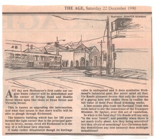 Melbourne Tram Museum
Newspaper, The Age, demolition of the cable tram winding house on the corner of Hoddle and Bridge Road, 22/12/1990 12:00:00 AM
Newspaper clipping from The Age, 22/12/1990, about the demolition of the cable tram winding house on the corner of Hoddle and Bridge Road by VicRoads, to open the areas to traffic, despite National Trust pleas.trams, tramways, cable trams, bridge road, hoddle st, winding houses, power house, demolition, national trust -
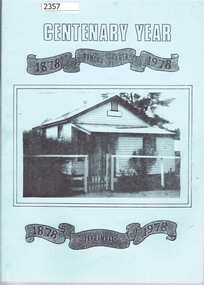 Greensborough Historical Society
Book, Tanck's Corner Yarrambat; Centenary Year 1878-1978, 1878-1978
A history of the primary school at Yarrambat, formerly called Tanck's Corner (until 1929), produced for the school centenary 1878-1978. Written and compiled by Eileen Hooper, design and technical advice from Alan White.A full history of the school including reasons for its establishment and a roll call of students from 1878 to 1978, Third reprint (1995) published with assistance of Yarrambat Historical Society100 pages plus addendum to 3rd reprint. Black and white photographs. Pale blue soft cover with photograph of original school building. 2015 copy has addendum with pupil enrolments to 2015.Inscribed inside front cover : "Noel, sincere thanks for your support, YHS members. 9.6.09" Addendum to 2015:item 2359.yarrambat primary school, tancks corner -
 Ringwood and District Historical Society
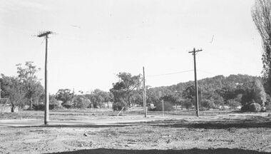
Photograph, Looking East along Oban Road from roundabout at corner of Wonga Rd 1981
Written on back of photograph, "29.6.81. Looking East along Oban Road from roundabout at corner of Wonga Rd." -
 Ringwood and District Historical Society
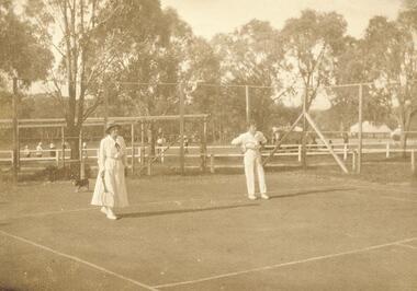
Photograph, Ringwood Tennis Courts, south-west corner of Ringwood Oval, 1920
Catalogue card reads, "Ringwood Tennis Courts, south-west corner of Ringwood Oval, 1920". (3 copies) -
 Ringwood and District Historical Society
Photograph, S.W. corner Bond and Ringwood Street. No.21 Ringwood St. Ringwood 1981
Written on back of photograph, "18/5/81. S.W. corner Bond and Ringwood Street. No.21 Ringwood St." -
 Ringwood and District Historical Society
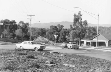
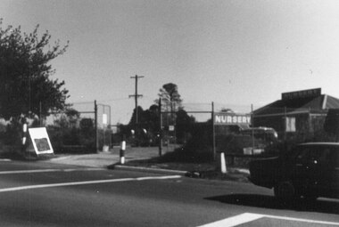
Photograph, Nursery on north-west corner of intersection of Warrandyte and Oban Roads. North Ringwood 1981
Written on back of photograph, "18/4/81. Nursery on north-west corner of intersection of Warrandyte and Oban Roads". -
 Ringwood and District Historical Society
Photograph, Maroondah nHighway East, Ringwood- c.1920's. Roadworks at corner of Whitehorse and Warrandyte Roads
Black and white photograph (2 copies)Typed below photograph: "Roadworks at corner of Maroondah Highway and Warrandyte Roads. Buildings far right still there (1979)." -
 Ringwood and District Historical Society
Photograph, View from Colemans Estate Heathmont, 1923. Near corner of Bedford and Canterbury Roads
Typed below photograph, "View from Colemans Estate Heathmont, 1923. Near corner of Bedford and Canterbury Roads". -
 Ringwood and District Historical Society
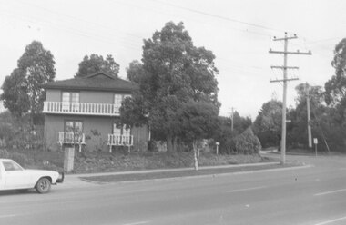
Photograph, Laid house in Miles Avenue. On the east corner of Melbourne Street. Ringwood 1987
Written on back of photograph, "9 Jan. 1987. Laid house in Miles Avenue. On the east corner of Melbourne Street". -
 Surrey Hills Historical Society Collection
Photograph, 316 Canterbury Road, corner of Essex Road
Mr Walter Sessford Cornhill was born in c1886 in Orsett, Essex; died 2 September 1940 and buried in Box Hill Cemetery (B-069-0028). He was a carpenter. He married Rhoda Fraser (1882-1947). A son John Edmund was a plumber. Daughter Lillian married Charles Frederick Barrow. Walter Cornhill moved from 3 Essex Road to 316 Canterbury Road some tome after 1937. The house passed to Charles Frederick Barrow and wife Lillian and subsequently to Leonard Clement Gangell and his wife Pamela Gangell, nee Barrow.A black and white photograph of an early modern style house built on a corner block. It is built of brick. The upper portion of the house is rendered with occasional brickwork patterning. A low brick fence borders both street frontages.canterbury road, essex road, 1940, early modern style, mr walter sessford cornhill, mrs rhoda cornhill, miss rhoda fraser, mr john edmund cornhill, miss lillian cornhill, mr charles frederick barrow, mrs lillian barrow -
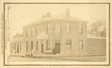 Bacchus Marsh & District Historical Society
Photograph, Royal Hotel corner of Main and Young Streets Bacchus Marsh 1883
This image is one of a series of photographs taken by Melbourne based photographers Stevenson and McNicoll who visited Bacchus Marsh nearby districts between September and November 1883. The Royal Hotel was built in 1861 and is located on the corner of Main and Young Streets in Bacchus Marsh. The first owner was James Murray and the hotel was first known as the Murray Family Hotel. James Murray died in an accident in 1863 and sometime after this the ownership passed to Richard Manning. From around 1869 it became known as the Royal Hotel. Richard Manning's son Frederick Manning inherited the hotel in 1896. The Manning family owned the hotel until sometime after 1945. In more recent decades it has been owned and operated by a number of different people. The hotel continues to operate as of 2024. This image shows the building in its original structure. In 1888, five years after this image was taken, a second storey was added to the section on Young Street. In this image this section is the single storey section of wall without windows to the right of the picture. Small sepia 'carte de viste' style unframed photograph on card with gold border framing photograph. Housed in the album, 'Photographs of Bacchus Marsh and District in 1883 by Stevenson and McNicoll'. The image shows the Royal Hotel seen from the intersection of Main and Young Streets. The diagonal view shows both the Main Street and Young Street sides of the building. It is a two storey brick building with a single storey brick extension on the Young Street frontage. Standing at the corner of the building is a woman and five girls. A deep gutter runs along the Main Street, with a pedestrian crossing ramp. Over this crossing point, there is a large metal frame bearing an ornate lantern. Next to it is a water trough for horses. Several hitching posts can be seen along the footpaths.Printed On the front: Stevenson & McNicoll. Photo. 108 Elizabeth St. Melbourne. COPIES CAN BE OBTAINED AT ANY TIME. On the back: LIGHT & TRUTH inscribed on a banner surmounted by a representation of the rising sun. Copies of this Portrait can be had at any time by sending the Name and Post Office Money Order or Stamps for the amount of order to STEVENSON & McNICOLL LATE BENSON & STEVENSON, Photographers. 108 Elizabeth Street, MELBOURNE. stevenson and mcnicoll 1883 photographs of bacchus marsh and district, hotels bacchus marsh, royal hotel bacchus marsh, manning family bacchus marsh, murray family hotel bacchus marsh -
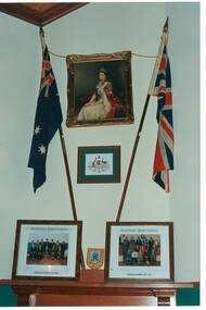 Buninyong & District Historical Society
Photograph - Original Photograph, Mr. C.J. Brooks, Corner wall and mantel piece of 1886 Buninyong Courthouse. portrait of QEII framed by Australian flag and Union Jack, November 1995
Social/ political, legalColour photo, Corner wall and mantel piece of 1886 Buninyong Courthouse. portrait of QEII framed by Australian flag and Union Jack, Victorian State Crest of Arms below portrait, group portaits of Buninyong Councillors on mantel.buninyong, courthouse, buninyong council chamber -
 Whitehorse Historical Society Inc.
Photograph, The Railway Crossing from Corner of Springvale Road & Station, 1/06/2009
One of a collection of photographs taken of the Nunawading Railway Station prior to the lowering of the railway line and building of the new railway station on the western side of Springvale Road so that the Springvale Road Rail Crossing can be eliminated.Black & white photograph of he precinct surrounding the Nunawading Station and the Springvale Road Railway crossing. This photograph is of the Railway Crossing from corner of Springvale Road & Station. See NP 3545 to NP3567for the complete set of photographsnunawading railway station, springvale road, nunawading, redevelopment of railway line/springvale road., station street nunawading -
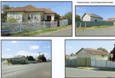 Stawell Historical Society Inc
Photograph, Mr W. J. Chapman -- Stawell Photographer's home on the corner of Maud and Grant Streets 2016
Home of W. J. Chapman Photographer of Stawell corner of Maud and Grant Streets. 8 Maud Street which later was renumbered 29 Grant Street. Photographic Studio back onto Grant Street. Photos Taken 2016.stawell business -
 Ballarat Tramway Museum
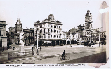
Photograph - Digital image, Rose Stereograph Co, "Corner of Lydiard and Sturt Streets, Ballarat", c1929
Digital image titled "The Corner of Lydiard and Sturt Streets Ballarat Vic", photo looks south west from the Post Office steps towards the south west corner - has Craigs Hotel, National Mutual Life, town hall shops including Anderson Printer and the Town Hall in the picture along with Robbie Burns statue. The Rose Series Postcard No. P 1783. An ESCo tram is parked at the tram stop - No. 5? A number of horse drawn and motor vehicles are in the photograph. Wal has dated the photo about 1930 on the rear of the postcard and about 1929 in his album notes. See item 9193 for a copy print.Yields information the buildings, buildings and scene at the intersection of Sturt and Lydiard St with a number of vehicles in the view.Digital image from the Wal Jack Ballarat Album of a postcard .trams, tramways, esco, lydiard st, sturt st, town hall, tram 5 ? -
 Ballarat Tramway Museum
Postcard, Rose Stereograph Co, "Corner of Lydiard and Sturt Streets, Ballarat", c1929
postcard - titled "The Corner of Lydiard and Sturt Streets Ballarat Vic", photo looks southwest from the Post Office steps towards the southwest corner - has Craigs Hotel, National Mutual Life, town hall shops including Anderson Printer and the Town Hall in the picture along with Robbie Burns statue. The Rose Series Postcard No. P 1783. An ESCo tram is parked at the tram stop - No. 5? Several horse-drawn and motor vehicles are in the photograph. Wal Jack has dated the photo about 1930 on the rear of the postcard and about 1929 in his album notes - see item 5126 for the digital image. Yields information the buildings, buildings and scene at the intersection of Sturt and Lydiard St with a number of vehicles in the view.Postcard or copy photograph of Rose Stereograph Co. postcard, No P 1783ballarat, trams, tramways, esco, lydiard st, sturt st, town hall, tram 5 ?