Showing 399 items
matching east st kilda
-
 Glen Eira Historical Society
Article - Packer Park
This file contains two items. An article from the Caulfield Port Phillip Leader on the reopening of Packer Park Cricket Oval, dated 11/01/2011. An article from the Caulfield Contact regarding the facilities and uses of Packer Park dated March 1992.packer park, parks, reserves, murrumbeena, caulfield, caulfield east, leila road, carnegie, packer john thomas, caulfield council, mayor of the city, velodromes, sportsgrounds, sports, recreations, entertainment, leisure, clubs, associations, sporting clubs, cultural structures, cultural establishments, sportspeople, football oval, cricket pitch, tennis wall, playgrounds, barbecues, spencer david, evans doug, d’zilva rod, football clubs, cricket clubs, community news, caulfield port phillip leader, st. kilda south caulfield amateur football club, washington park cricket club, st. patrick’s college old boys cricket club, st. peter’s college old boys cricket club, carnegie/caulfield cycle club, caulfield district horse and pony club, murrumbeena primary school, murrumbeena park, cricket oval, washington park cricket club, washington park sharks, dellora graeme, glen eira council, carnegie, tucker ward, magee tim, caulfield east ward -
 Glen Eira Historical Society
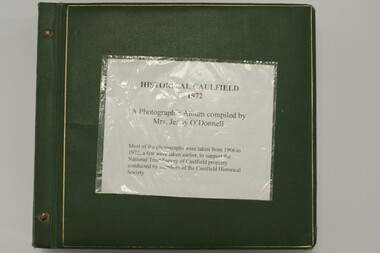
Album, Caulfield Historical Society Photograph Album 1972, 1972
... st kilda east... east caulfield north caulfield south elsternwick murrumbeena st ...This album was created in approximately 1972 as part of a project by the Caulfield Historical Society to assist in identifying buildings worthy of preservation. The album is related to a Survey the Caulfield Historical Society developed in collaboration with the National Trust of Australia (Victoria) and Caulfield City Council to identify historic buildings within the City of Caulfield that warranted the protection of a National Trust Classification. Principal photographer thought to be Trevor Hart, member of Caulfield Historical Society. Most photographs were taken between 1966-1972 with a small number of photographs being older and from unknown sources. All photographs are black and white except where stated.Photo album of buildings in Caulfield circa 1972 compiled alongside a project to assist National Trust Australia (Victoria) in identifying buildings worthy of preservation. All photos are black and white except where stated, with 386 photographs over 198 pages. Label on front is longstanding but not original or confirmed.caulfield, photographs, photo album, trevor hart, jenny o'donnell, jenny odonnell, caulfield historical society, glen eira historical society, carnegie, caulfield east, caulfield north, caulfield south, elsternwick, murrumbeena, st kilda east, houses, mansions, churches, schools, halls, shops, post offices, cinemas, town halls, hotels, banks, vicarages, bridges, gates, convents, bowling clubs, fire stations, roads and streets, caulfield historical album, 1970's, national trust of australia, city of caulfield, glen eira city council, national trust of australia (victoria) -
 Glen Eira Historical Society
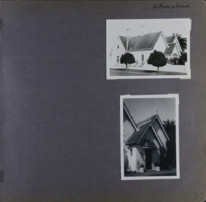
Album - Album page, Avoca Grove, 12, Circa 1972
... from its association with J. W. Stephens, MLA, for East St ...This photograph is part of the Caulfield Historical Album 1972. This album was created in approximately 1972 as part of a project by the Caulfield Historical Society to assist in identifying buildings worthy of preservation. The album is related to a Survey the Caulfield Historical Society developed in collaboration with the National Trust of Australia (Victoria) and Caulfield City Council to identify historic buildings within the City of Caulfield that warranted the protection of a National Trust Classification. Principal photographer thought to be Trevor Hart, member of Caulfield Historical Society. Most photographs were taken between 1966-1972 with a small number of photographs being older and from unknown sources. All photographs are black and white except where stated, with 386 photographs over 198 pages.From Glen Eira Heritage Management Plan (1996) by Andrew Ward and Associates: The house at 12 Avoca Grove, part of "Merton", now demolished, is understood to have been built for and occupied by James Wilberforce Stephens from c.1865. It has aesthetic and historical significance. The building's aesthetic value is derived from the manner in which it demonstrates aspects of the Cottage Orne style, popular among Melboume's gentry during the mid Victorian period. Its historical value is derived from its association with J. W. Stephens, MLA, for East St Kilda and a prominent Caulfield resident.Page 20 of Photograph Album - two black and white exterior photographs of a house with both photographs on the right hand side of the page, the top in landscape mode and the bottom portrait. Hand written: 12 Avoca Grove [top right of page] / 20 [bottom right]trevor hart, avoca grove, church, caulfield north, merton, james wilberforce stephens, cottage orne style, j w stephens (mla) -
 Glen Eira Historical Society
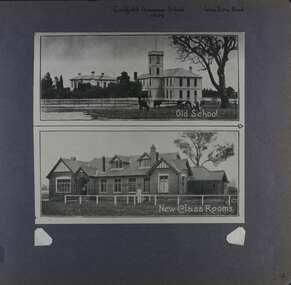
Album - Album page, Caulfield Grammar School, Glen Eira Road, Circa 1972
... st kilda east...217 Glen Eira Road, St Kilda East, Melbourne, Victoria... reverend j h davies education glen eira road st kilda east church ...This photograph is part of the Caulfield Historical Album 1972. This album was created in approximately 1972 as part of a project by the Caulfield Historical Society to assist in identifying buildings worthy of preservation. The album is related to a Survey the Caulfield Historical Society developed in collaboration with the National Trust of Australia (Victoria) and Caulfield City Council to identify historic buildings within the City of Caulfield that warranted the protection of a National Trust Classification. Principal photographer thought to be Trevor Hart, member of Caulfield Historical Society. Most photographs were taken between 1966-1972 with a small number of photographs being older and from unknown sources. All photographs are black and white except where stated, with 386 photographs over 198 pages. In 1881, Reverend J H Davies founded Caulfield Grammar School in Elsternwick, Victoria with just nine students.Page 54 of Photograph Album with one photograph of two images of Caulfield Grammar School. The images are vertically arranged and joining.Hand written: Caulfield Grammar School / 1909 [middle top] / Glen Eira Road [top right ]/ 54 [bottom right]. Top image includes a printed title "Old School" and the bottom image "New Class Rooms".trevor hart, 1880's, 1890's, elsternwick, caulfield grammar school, reverend j h davies, education, glen eira road, st kilda east, church of england, double storey school buildings -
 Glen Eira Historical Society
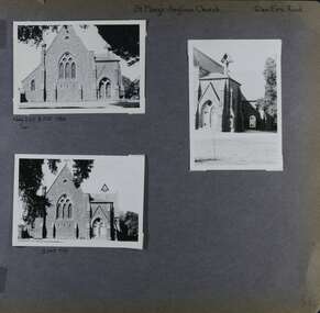
Album - Album page, St Mary's Anglican Church, Glen Eira Road, Circa 1972
... st kilda east.... trevor hart 1880's elsternwick glen eira road st kilda east ...This photograph is part of the Caulfield Historical Album 1972. This album was created in approximately 1972 as part of a project by the Caulfield Historical Society to assist in identifying buildings worthy of preservation. The album is related to a Survey the Caulfield Historical Society developed in collaboration with the National Trust of Australia (Victoria) and Caulfield City Council to identify historic buildings within the City of Caulfield that warranted the protection of a National Trust Classification. Principal photographer thought to be Trevor Hart, member of Caulfield Historical Society. Most photographs were taken between 1966-1972 with a small number of photographs being older and from unknown sources. All photographs are black and white except where stated, with 386 photographs over 198 pages.From the Victorian Heritage Register Database - Citation for St Mary's Anglican Church https://vhd.heritagecouncil.vic.gov.au/places/43715 (as at 14/10/2020) St Mary's has architectural significance as a representative example of French influenced Low and Mixed Gothic (see stylistic Typology in National Trust's Historic Churches Study) and is further distinguished by its use of bluestone, entirely without relief. French influence is demonstrated by the high nave, apsidal sanctuary, spirelet and trumeau. The building is locally important as a historic focus for Anglican worship and early mission activity whilst its architectural grandeur is expressive of mid Victorian Caulfield's status as a suburban location for the Metropolis gentry.Page 56 of Photograph Album with three exterior photographs (two portrait and one landscape) of St Mary's Anglican Church.Hand written: St Mary's Anglican Church Eira Road [top right] / Neg 235 8 Oct 1966 [under top left photo] / 3 Sep 1972 [under bottom left photo] / 56 [bottom right] trevor hart, 1880's, elsternwick, glen eira road, st kilda east, church of england, gothic, st mary's, bluestone, apsidal sanctuary, spirelet, trumeau, anglican, 1870's, caulfield north, french-influenced low and mixed gothic style -
 Glen Eira Historical Society
Album - Album page, St Mary's Church Hall, Glen Eira Road, Circa 1972
... st kilda east.... trevor hart 1880's elsternwick glen eira road st kilda east ...This photograph is part of the Caulfield Historical Album 1972. This album was created in approximately 1972 as part of a project by the Caulfield Historical Society to assist in identifying buildings worthy of preservation. The album is related to a Survey the Caulfield Historical Society developed in collaboration with the National Trust of Australia (Victoria) and Caulfield City Council to identify historic buildings within the City of Caulfield that warranted the protection of a National Trust Classification. Principal photographer thought to be Trevor Hart, member of Caulfield Historical Society. Most photographs were taken between 1966-1972 with a small number of photographs being older and from unknown sources. All photographs are black and white except where stated, with 386 photographs over 198 pages. The Jubilee School on the corner of Hood Crescent and Glen Eira Road was built in 1887 AD to commemorate Queen Victoria’s Jubilee.Victorian Heritage Database https://vhd.heritagecouncil.vic.gov.au/places/43705 The former St Mary's Jubilee School is locally significant as an early purpose built church school, associated with St Mary's Church. Its use of polychrome brick is locally conspicuous whilst the adoption of the Gothic Style not only underlines its Christian foundations but relates to the comparable schools of the Public Works Department of the same period.Page 57 of Photograph Album with four exterior photographs (2 portrait and 2 landscape) of St Mary's Church Hall. Bottom right photograph is a photo of a photo.Hand written: St Mary's Church Hall - Glen Eira Road [top left] / Neg 233 8 Oct 1966 [under top left photo] / 3 Sept 1972 [under bottom left photo] / bottom right photo titled "St Mary's Sunday School" / 57 [bottom left] trevor hart, 1880's, elsternwick, glen eira road, st kilda east, church of england, st mary's, caulfield north, st mary's anglican church hall, hood crescent, jubilee school, polychrome brickwork, curved windows, church hall, queen victoria’s jubilee, victorian, sunday schools, st mary's jubilee school, gothic style -
 City of Moorabbin Historical Society (Operating the Box Cottage Museum)
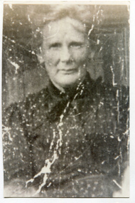
Photograph, B&W, Anna Box 1849 - 1919, c1912
Anna Box 1849- 1919 was born in Withyham, Sussex England had her 7th birthday en route from Liverpool to Australia. George Box 1808-1867 of Sussex England, married Mary Cripps in 1831 and with 3 three of their 4 four sons and 3 three of their 4 four daughters left Liverpool in the Sailing Ship 'Atlanta' in March 1856 to begin a new life in Melbourne, Victoria , Australia. Their baby daughter Cecilia Lydia died a few days later. Caroline Box, the eldest daughter, remained in England working as a cook until she joined the family in Australia in 1863. William Box 1834-1902, the eldest son of George Box, married Elizabeth Avis 1833- 1914 and they resided in Box Cottage 1865 -1914 where they established a market garden and raised 13 children. William and Elizabeth had emigrated in 1854 so George worked on their market garden before setting up in Patterson Road. Sadly Mary drowned in a water hole only 4 months after their arrival in Brighton. It is supposed that Elizabeth helped George raise the children while he established his market garden. George died from Tetanus following an infected broken leg caused by falling from his dray in 1867. Anna was a dressmaker and in 1881 she married Henry Pay , a painter, from London and they had 3 children . In 1907 the family lived on a 30acre property in Ringwood. which Anna bequeathed to her children. – Beatrice, Norman and Laura. In 1911 they moved to Surrey Hills where Anna died in 1919. Henry died in 1935 in Montrose where he was living with his son Norman Henry Pay, a farmer . Box Cottage Museum, a reconstruction of an early settler hut, is named after the Box family who resided there 1865 -1913 . William Box who, with his wife Elizabeth Avis Box and 13 children, lived and farmed on the block of land in Jasper Road, East Brighton ( now McKinnon / Ormond) that was part of the Henry Dendy Special Survey 1841. George Box 1808-1867 migrated in 1856 and worked with his son William Box until he established a market garden in Patterson Rd . East Brighton ( now Bentleigh). Anna Box –Pay was the 3rd daughter of George and Mary Box. A black and white photograph of Anna Box 1849-1919nilbox anna, pay henry, pay norman, box william, box elizabeth avis, box george, box mary, moorabbin, bentleigh, brighton, ormond, market gardeners, pioneers, early settlers, withyham sussex england, ringwood melbourne, pay beatrice, pay laura, st kilda, melbourne, -
 City of Moorabbin Historical Society (Operating the Box Cottage Museum)
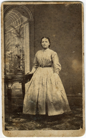
Photograph - Photographs x2, B&W, possibly Anna Box and Henry Pay, c1881
Anna Box 1849- 1919 was born in Withyham, Sussex England had her 7th birthday en route from Liverpool to Australia. George Box 1808-1867 of Sussex England, married Mary Cripps in 1831 and with 3 three of their 4 four sons and 3 three of their 4 four daughters left Liverpool in the Sailing Ship 'Atlanta' in March 1856 to begin a new life in Melbourne, Victoria , Australia. Their baby daughter Cecilia Lydia died a few days later. Caroline Box, the eldest daughter, remained in England working as a cook until she joined the family in Australia in 1863. William Box 1834-1902, the eldest son of George Box, married Elizabeth Avis 1833- 1914 and they resided in Box Cottage 1865 -1914 where they established a market garden and raised 13 children. William and Elizabeth had emigrated in 1854 so George worked on their market garden before setting up in Patterson Road. Sadly Mary drowned in a water hole only 4 months after their arrival in Brighton. It is supposed that Elizabeth helped George raise the children while he established his market garden. George died from Tetanus following an infected broken leg caused by falling from his dray in 1867. Anna was a dressmaker and in 1881 she married Henry Pay , a painter, from London and they had 3 children . In 1907 the family lived on a 30acre property in Ringwood which Anna bequeathed to her children. – Beatrice, Norman and Laura. In 1911 they moved to Surrey Hills where Anna died in 1919. Henry died in 1935 in Montrose where he was living with his son Norman Henry Pay, a farmer . Box Cottage Museum, a reconstruction of an early settler hut, is named after the Box family who resided there 1865 -1913 . William Box who, with his wife Elizabeth Avis Box and 13 children, lived and farmed on the block of land in Jasper Road, East Brighton ( now McKinnon / Ormond) that was part of the Henry Dendy Special Survey 1841. George Box 1808-1867 migrated in 1856 and worked with his son William Box until he established a market garden in Patterson Rd . East Brighton ( now Bentleigh). Anna Box –Pay was the 3rd daughter of George and Mary Box. 2 black and white photographs that may be of A ) Anna Box and B) her husband Henry Pay A) nil B) J P LIND Photo 82 Swanston St.box anna, pay henry, pay norman, box william, box elizabeth avis, box george, box mary, moorabbin, bentleigh, brighton, ormond, market gardeners, pioneers, early settlers, withyham sussex england, ringwood melbourne, pay beatrice, pay laura, st kilda, melbourne -
 City of Moorabbin Historical Society (Operating the Box Cottage Museum)
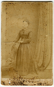
Photographs, 2 x B&W, possibly Anna Box 1849 - 1919, c1880
Anna Box 1849- 1919 was born in Withyham, Sussex England had her 7th birthday en route from Liverpool to Australia. George Box 1808-1867 of Sussex England, married Mary Cripps in 1831 and with 3 three of their 4 four sons and 3 three of their 4 four daughters left Liverpool in the Sailing Ship 'Atlanta' in March 1856 to begin a new life in Melbourne, Victoria , Australia. Their baby daughter Cecilia Lydia died a few days later. Caroline Box, the eldest daughter, remained in England working as a cook until she joined the family in Australia in 1863. William Box 1834-1902, the eldest son of George Box, married Elizabeth Avis 1833- 1914 and they resided in Box Cottage 1865 -1914 where they established a market garden and raised 13 children. William and Elizabeth had emigrated in 1854 so George worked on their market garden before setting up in Patterson Road. Sadly Mary drowned in a water hole only 4 months after their arrival in Brighton. It is supposed that Elizabeth helped George raise the children while he established his market garden. George died from Tetanus following an infected broken leg caused by falling from his dray in 1867. Anna was a dressmaker and in 1881 she married Henry Pay , a painter, from London and they had 3 children . In 1907 the family lived on a 30acre property in Ringwood. which Anna bequeathed to her children. – Beatrice, Norman and Laura. In 1911 they moved to Surrey Hills where Anna died in 1919. Henry died in 1935 in Montrose where he was living with his son Norman Henry Pay, a farmer . Box Cottage Museum, a reconstruction of an early settler hut, is named after the Box family who resided there 1865 -1913 . William Box who, with his wife Elizabeth Avis Box and 13 children, lived and farmed on the block of land in Jasper Road, East Brighton ( now McKinnon / Ormond) that was part of the Henry Dendy Special Survey 1841. George Box 1808-1867 migrated in 1856 and worked with his son William Box until he established a market garden in Patterson Rd . East Brighton ( now Bentleigh). Anna Box –Pay was the 3rd daughter of George and Mary Box. 2 black and white photographs that Avis Box Leigh thinks may be Anna Box c1880A unreadable B Ferry 49 Elizabeth St . Melbournebox anna, pay henry, pay norman, box william, box elizabeth avis, box george, box mary, moorabbin, bentleigh, brighton, ormond, market gardeners, pioneers, early settlers, withyham sussex england, ringwood melbourne, pay beatrice, pay laura, st kilda, melbourne -
 Bendigo Historical Society Inc.
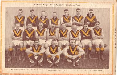
Newspaper - WEEKLY TIMES SPORT, 1928
Brown paper folder containing cuttings from Weekly Times showing football teams and cricket teams. Football teams include North Melbourne, East Albury, Horsham, Dimboola, Echuca, Nhill, Preston, Port Melbourne, Essendon, Wangaratta, Preston, Benalla, Hamilton, Kyabram, Echuca, Shepparton, Castlemaine, Sandhurst, Albury, St. Patrick's, Maryborough, Brunswick, Wimmera, Gippsland, St. Kilda, Melbourne Grammar, South Melbourne and Hawthorn. Cricket teams include the English Cricket Team and the Australian Team (1928).newspaper, football -
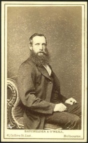 Deaf Children Australia
Photograph, Portrait of a man, 1857-1864?
A sepia coloured portrait of a man on card. On back 'BATCHELDER & O'NEILL/ARTIST PHOTOGRAPHERS/41 COLLINS ST. EAST,/MELBOURNE/Est 1854' deaf children australia, victorian deaf & dumb institution, vddi, portrait -
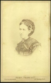 Deaf Children Australia
Photograph, Portrait of a woman, 1873-1875
A sepia coloured portrait of a woman on card. On back 'KEMP, PERRY & CO/Artists and Photographers./81 BOURKE ST. EAST./2 doors East of/THEATRE ROYAL/MELBOURNE' / 'PHOTOGRAPHIC COPIES & PORTRAITS IN OILS & WATER COLORS/CAN BE HAD FROM THIS CARD.' deaf children australia, victorian deaf & dumb institution -
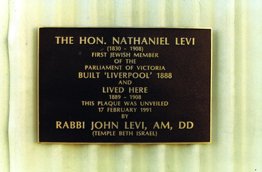 St Kilda Historical Society
Photograph
The Hon. Nathaniel Levi (1830-1908) was the first Jewish Member of the Parliament of Victoria. He served in the Legislative Assembly from 1861-1867, representing the electorates of Maryborough (1 Jan 1861 - 1 Dec 1865) and East Melbourne (1 Feb 1866 - 1 Dec 1867). He later served in the Legislative Council for the North Yarra electorate (1 Sep 1872 - 1 Jan 1904). Born in Liverpool on 20 Jan 1830, he arrived in Melbourne in April 1854 on the Matilda Wattenbach, opened a store and established a career as a businessman. In 1858 he joined the firm of John Levey & Son, Melbourne and Maryborough. He pioneered the coal and sugar beet industries; established the firm of Nathaniel Levi & Company c1867; commenced auctioneering and agency business c1870; obtained contract for railway advertising c1875; with his two sons (Joseph and John) as partners, the firm became Nathaniel Levi & Sons c1884. He commenced a short-lived newspaper, the Daily News, in Oct 1885. He was a founder and trustee of the Chamber of Manufactures, and its President 1893-1895. He married Sarah Levy in 1855. Nathaniel Levi was prominent in the Jewish community and was President of the Melbourne Hebrew Congregation in 1880–82 and 1904–05. He is a forebear of Rabbi John Levi.colour photograph unmountedThe Hon. Nathaniel Levi (1830-1908) first Jewish member of the Parliament of Victoria. Built "Liverpool" 1888 and lived here 1889-1908. This plaque was unveiled 17 February 1991 by Rabbi John Levi AM DD (Temple Beth Israel)plaques, st kilda, nathaniel levi, hon nathaniel levi, member of parliament, liverpool, princes street -
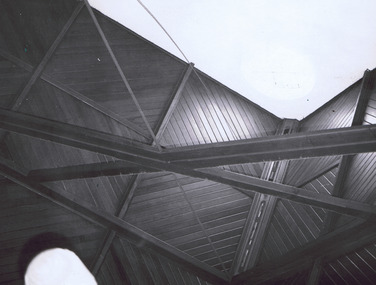 St Kilda Historical Society
Photograph
... to its sister church, East St Kilda Congregational Church ...St John’s Congregational Church was established in 1888 on the corner of Barkly and Mitford Streets, near the Village Belle Hotel in South St Kilda. The building has now been demolished. The photograph was taken at the final service. The church closed in 1974 and gave its hymn books, carpets and curtains to its sister church, East St Kilda Congregational Church at the corner of Hotham and Inkerman Streets (later East St Kilda Uniting Church and now Trinity-St Nicholas Church).black and white photographPortion of ceiling of St John Cong. Church South S Kilda. Closing Service 31 Dec 1973st kilda, churches, st john's congregational church, congregational churches -
 St Kilda Historical Society
Photograph - Photo map, 17/01/1951
... St Kilda East...St Kilda Historical Society St Kilda Branch Library 150 ...One of a series of photo-maps produced for the Department of Crown Lands and Survey (1857-1983). For correlation with a current map, and access to other historical photo maps of Victoria, see the Historic Photo-Maps Index published by the Department of Environment, Land, Water and Planning at https://services.land.vic.gov.au/DELWPmaps/historical-photomaps/Black and white aerial photograph1414-20 538 Run 19 Lens 12" Melbourne Metropolitan 12150 17.1.51 M586elwood, elsternwick, st kilda east, balaclava, ripponlea, 1951 -
 St Kilda Historical Society
Photograph - Photo map, 28/01/1951
... St Kilda East... cemetery Caulfield North St Kilda East 1951 1424-43 534 Run 18 Lens ...One of a series of photo-maps produced for the Department of Crown Lands and Survey (1857-1983). For correlation with a current map, and access to other historical photo maps of Victoria, see the Historic Photo-Maps Index published by the Department of Environment, Land, Water and Planning at https://services.land.vic.gov.au/DELWPmaps/historical-photomaps/Black and white aerial photograph1424-43 534 Run 18 Lens 12" Melbourne Metropolitan 12150 28.1.51 M639armadale, malvern, st kilda cemetery, caulfield north, st kilda east, 1951 -
 St Kilda Historical Society
Photograph - Photo map, 30/01/1960
... St Kilda East... Elsternwick Park Ripponlea St Kilda East Caulfield Balaclava 1960 Vic ...One of a series of photo-maps produced for the Department of Crown Lands and Survey (1857-1983). For correlation with a current map, and access to other historical photo maps of Victoria, see the Historic Photo-Maps Index published by the Department of Environment, Land, Water and Planning at https://services.land.vic.gov.au/DELWPmaps/historical-photomaps/Black and white aerial photographVic 1091-110 Melbourne & Metropolitan Project Run 23East 30.1.60 Lens 10" 8.200elwood, elsternwick, elsternwick park, ripponlea, st kilda east, caulfield, balaclava, 1960 -
 St Kilda Historical Society
Photograph - Photo map, 14/12/1963
... St Kilda East... Park St Kilda East Balaclava 1963 Vic 1807 Melbourne 1963 ...One of a series of photo-maps produced for the Department of Crown Lands and Survey (1857-1983). For correlation with a current map, and access to other historical photo maps of Victoria, see the Historic Photo-Maps Index published by the Department of Environment, Land, Water and Planning at https://services.land.vic.gov.au/DELWPmaps/historical-photomaps/Black and white aerial photographVic 1807 Melbourne 1963 Project Run 16 14.12.63 Lens 205 152.70 M/M 5.150 179st kilda, prahran, albert park, st kilda east, balaclava, 1963 -
 St Kilda Historical Society
Photograph - Photo map, 14/12/1963
... St Kilda East... Caulfield North St Kilda East Armadale Malvern 1963 Vic 1807 ...One of a series of photo-maps produced for the Department of Crown Lands and Survey (1857-1983). For correlation with a current map, and access to other historical photo maps of Victoria, see the Historic Photo-Maps Index published by the Department of Environment, Land, Water and Planning at https://services.land.vic.gov.au/DELWPmaps/historical-photomaps/Black and white aerial photographVic 1807 Melbourne 1963 Project Run 16 14.12.63 Lens 205 152.70 M/M 5.150 181st kilda cemetery, caulfield north, st kilda east, armadale, malvern, 1963 -
 St Kilda Historical Society
Photograph - Photo map, 12/04/1966
... St Kilda East...://services.land.vic.gov.au/DELWPmaps/historical-photomaps/ St Kilda St Kilda East ...One of a series of photo-maps produced for the Department of Crown Lands and Survey (1857-1983). For correlation with a current map, and access to other historical photo maps of Victoria, see the Historic Photo-Maps Index published by the Department of Environment, Land, Water and Planning at https://services.land.vic.gov.au/DELWPmaps/historical-photomaps/Black and white aerial photographVic 1933 Melbourne 1966 Project Run 12 12.4.66 Lens 122 151.75MM 9.800 154st kilda, st kilda east, balaclava, toorak, amadale, caulfield, south yarra, st kilda botanical gardens, peanut farm, 1966 -
 St Kilda Historical Society
Photograph - Photo map, 08/02/1966
... St Kilda East... Caulfield Caulfield North St Kilda East Elsternwick Elsterwick Park ...One of a series of photo-maps produced for the Department of Crown Lands and Survey (1857-1983). For correlation with a current map, and access to other historical photo maps of Victoria, see the Historic Photo-Maps Index published by the Department of Environment, Land, Water and Planning at https://services.land.vic.gov.au/DELWPmaps/historical-photomaps/Black and white aerial photographVic 1916 Melbourne 1966 Project Run 13 E 8.2.66 Lens 122 151.75MM 9.800 111st kilda, balaclava, caulfield, caulfield north, st kilda east, elsternwick, elsterwick park, elwood park, elwood canal, elwood beach, ripponlea, 1966 -
 St Kilda Historical Society
Photograph - Photo map, 11/01/1968
... St Kilda East... Kilda East Ripponlea Elwood Elsternwick Caulfield St Kilda ...One of a series of photo-maps produced for the Department of Crown Lands and Survey (1857-1983). For correlation with a current map, and access to other historical photo maps of Victoria, see the Historic Photo-Maps Index published by the Department of Environment, Land, Water and Planning at https://services.land.vic.gov.au/DELWPmaps/historical-photomaps/Black and white aerial photographVic 2132 State Aerial Survey Melbourne 1968 Proj. Run 28E 11.1.68 5100 ASL 81st kilda, balaclava, st kilda east, ripponlea, elwood, elsternwick, caulfield, st kilda botanical gardens, 1968 -
 St Kilda Historical Society
Photograph - Photo map, Department of Crown Lands and Survey (1857-1983), 22/01/1970
... St Kilda EAst... St Kilda EAst Armadale 1970 Vic 2358 Department of Crown ...One of a series of photo-maps produced for the Department of Crown Lands and Survey (1857-1983). For correlation with a current map, and access to other historical photo maps of Victoria, see the Historic Photo-Maps Index published by the Department of Environment, Land, Water and Planning at https://services.land.vic.gov.au/DELWPmaps/historical-photomaps/Black and white aerial photographVic 2358 Department of Crown Lands and Survey Victoria,.© Melbourne 1970 Project Run 41E 22.1.70 5,100 ASL 62caulfield, caulfield north, st kilda east, armadale, 1970 -
 St Kilda Historical Society
Photograph - Photo map, 14/12/1963
... St Kilda East... Botanical Gardens Balaclava St Kilda East Elwood Canal Ripponlea ...One of a series of photo-maps produced for the Department of Crown Lands and Survey (1857-1983). For correlation with a current map, and access to other historical photo maps of Victoria, see the Historic Photo-Maps Index published by the Department of Environment, Land, Water and Planning at https://services.land.vic.gov.au/DELWPmaps/historical-photomaps/Black and white aerial photographVic 1807 Melbourne 1963 Project Run 17 14.12.63 Lens 205 152.70 M/M 5.150 36st kilda, st kilda botanical gardens, balaclava, st kilda east, elwood canal, ripponlea, caulfield north, elwood, caulfield, 1963 -
 St Kilda Historical Society
Photograph - Photo map, Department of Crown Lands and Survey, 22/01/1970
... St Kilda East... Balaclava St Kilda East Windsor Caulfield North Alma Park 1970 Vic ...One of a series of photo-maps produced for the Department of Crown Lands and Survey (1857-1983). For correlation with a current map, and access to other historical photo maps of Victoria, see the Historic Photo-Maps Index published by the Department of Environment, Land, Water and Planning at https://services.land.vic.gov.au/DELWPmaps/historical-photomaps/Black and white aerial photographVic 2358 Department of Crown Lands and Survey Victoria,.© Melbourne 1970 Project Run 41E 22.1.70 5,100 ASL 64st kilda, st kilda cemetery, balaclava, st kilda east, windsor, caulfield north, alma park, 1970 -
 St Kilda Historical Society
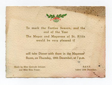
Ephemera - Invitation - mayoral dinner, To mark the Festive Season and the end of the Year, 1918 or 1929
Although the name of the Mayor and Mayoress, and the year of the invitation are not stated, the fact that music was provided by 'Miss Gertrude Emily Johnson' provides a possible clue as to the date. Gertrude Emily Johnson (1894-1973), coloratura soprano and theatre administrator, was born on 13 September 1894 at Prahran, Melbourne. She was a student of (Dame) Nellie Melba at the women's singing school that Melba founded at the Albert Street Conservatorium, East Melbourne (later the Melba Memorial Conservatorium). The date specified in the invitation, Thursday 19th December, indicates that the event was either in 1918 or 1929. As Gertrude Johnson moved to London in February 1921 and returned to Australia in 1935, when she retired from her singing career, it appears likely that the invitation to the mayoral dinner was for 19 December 1918. Elsie Fraser would have accompanied her on the piano.Cream coloured card printed in gold and with Christmas bells and holly in green and red, being an invitation for dinner with the Mayor and Mayoress of St KildaTo mark the Festive Season, and the end of the Year, the Mayor and Mayoress of St Kilda would be very pleased if ... will take Dinner with them in the Mayoress' Room, on Thursday, 19th December, at 7pm. Music by Miss Gertrude Johnson and Miss Elsie Fraser. RSVP before 12th December.gertrude johnson, elsie fraser, st kilda council, st kilda mayoral function -
 St Kilda Historical Society
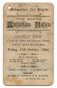
Ephemera - Dance card, Metropolitan Fire Brigade The Ninth Annual Ball, 1901
From 1845, separate and competing volunteer fire brigades were established in Melbourne and grew in number. Following the passage of the Fire Brigades Act 1890 and the creation of the Metropolitan Fire Brigade (MFB) on 1 May 1891, the 56 volunteer brigades that then existed were disbanded and the firefighters were invited to join the MFB. The MFB was abolished in 2020 and the firefighters absorbed into the newly established Fire Rescue Victoria.White coloured rectangular shaped card printed in black on both sides. Hole in top left hand corner.Front Metropolitan Fire Brigade. The Ninth Annual Ball. Orderly Room (Corner of Albert and Gisborne Streets) EAST MELBOURNE, Friday, 11th October, 1901. MFB QUADRILLE. 1st Fig. 1st Set; 3rd Fig, 1st Set; 3rd Fig. Lancers; Spanish Waltz; Circassian Figure. JARRETT'S BAND. J. C. PRICE, M. C. Stewards: MESSRS. H. HARRISON 7 R. GLENNON W. CAVE, Hon. Sec. Back: List of dances, against which some names and initials have been written by handmetropolitan fire brigade, orderly room - east melbourne, jarrett's band, 20th century, melbourne - history -
 St Kilda Historical Society
Ephemera - Ticket, Picnic to Park Orchards, 1936
Ticket to picnic at Park Orchards on 21 December 1936, organised by the St Kilda Unemployed Organisation with the support of the St Kilda City Council, Mayor (Cr Alfred Levy), Archie Michaelis MLA, and 'other well-known gentlemen'. The ticket appears to have been perforated to allow vouchers, printed on the back (for bus, dinner, toys, stockings, ice cream and tea) to be separated and used. Park Orchards is a residential suburb 23km north east of Melbourne that was created in 1925 on land used for orchards when timber merchants Australis Sharp and John Taylor launched the Park Orchards Country Club estate. Buyers were not attracted to the estate, and for many years all that existed were a clubhouse and various sporting facilities. It gained popularity when demand for housing surged in the 1950s.Grey/green coloured card, printed in blue on both sides and with 5 evenly spaced lines of perforations across the width.st kilda unemployed organisation, st kilda council -
 St Kilda Historical Society
Postcard - Photograph Streetscape, Fitzroy St, St Kilda
view from south west end of Fitzroy St looking north eastblack and white photograph -
 St Kilda Historical Society
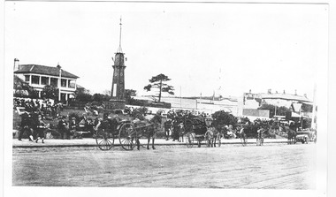
Postcard, Boer War Memorial, Alfred Square, Esplanade East, c. 1890
black and white photograph, unmounted copy, good conditionMelbourne -Suburbs St Kilda Alfred Square and Soldiers Memorial from the Esplanade. St Kilda by the Sea Annual Season 1915/16 p.107 F600:65 c1890